
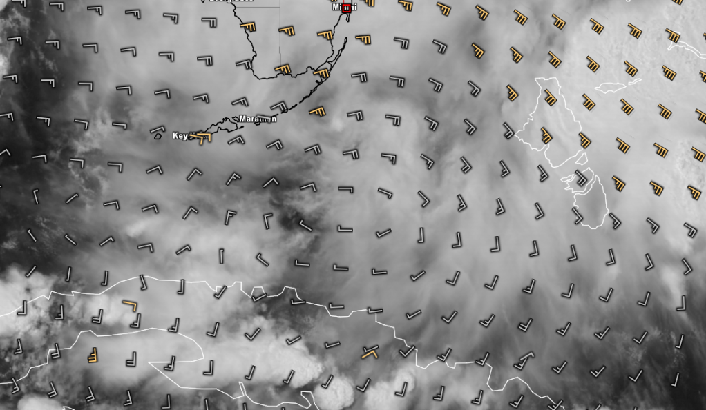
Upper level winds are in good shape and slight rotation on radar...likely mid-level
Strong squall line coming into S FL 47mph
http://www.wunderground.com/MAR/buoy/FWYF1.html
Complex in Northeast GOM
Moderator: S2k Moderators
Forum rules

The posts in this forum are NOT official forecasts and should not be used as such. They are just the opinion of the poster and may or may not be backed by sound meteorological data. They are NOT endorsed by any professional institution or STORM2K. For official information, please refer to products from the National Hurricane Center and National Weather Service.
Complex in Northeast GOM
Last edited by drezee on Sun Jul 22, 2012 9:19 am, edited 1 time in total.
0 likes

This tropical wave blew up out of no where during the night, thanks to UL divergence. It has brought back the Saharan dust to central FL this morning.
It has a vorticity but mostly in the mid levels, it also has a little bit of surface convergence.
What seems to be interesting is how a majority of the tropical waves during the past month have reached FL and into the GOM, unlike the last couple of years.
It has a vorticity but mostly in the mid levels, it also has a little bit of surface convergence.
What seems to be interesting is how a majority of the tropical waves during the past month have reached FL and into the GOM, unlike the last couple of years.
0 likes
-
AdamFirst

- S2K Supporter

- Posts: 2490
- Age: 36
- Joined: Thu Aug 14, 2008 10:54 am
- Location: Port Saint Lucie, FL
Re: Complex near S FL
10%

SPECIAL TROPICAL WEATHER OUTLOOK
NWS NATIONAL HURRICANE CENTER MIAMI FL
1040 AM EDT SUN JUL 22 2012
FOR THE NORTH ATLANTIC...CARIBBEAN SEA AND THE GULF OF MEXICO...
1. A VIGOROUS TROPICAL WAVE LOCATED OVER THE NORTHWESTERN BAHAMAS AND
THE FLORIDA STRAITS IS PRODUCING NUMEROUS SHOWERS AND A FEW STRONG
THUNDERSTORMS. A WIND GUST TO 53 MPH WAS RECENTLY REPORTED AT FOWEY
ROCKS FLORIDA...AND DOPPLER WEATHER DATA INDICATE STRONGER
THUNDERSTORMS ARE LOCATED OFFSHORE THE SOUTHEAST FLORIDA COAST.
SURFACE PRESSURES ARE HIGH AND UPPER-LEVEL WINDS ARE ONLY
MARGINALLY CONDUCIVE FOR DEVELOPMENT...SO ANY ADDITIONAL
ORGANIZATION OF THIS SYSTEM SHOULD BE SLOW TO OCCUR. REGARDLESS OF
DEVELOPMENT...THIS DISTURBANCE WILL BRING PERIODS OF STRONG GUSTY
WINDS AND LOCALLY HEAVY RAINFALL TO PORTIONS OF THE NORTHWESTERN
BAHAMAS...CENTRAL AND SOUTHERN FLORIDA...AND THE FLORIDA KEYS OVER
THE NEXT DAY OR SO. THIS SYSTEM HAS A LOW CHANCE...10 PERCENT...OF
BECOMING A TROPICAL CYCLONE DURING THE NEXT 48 HOURS AS IT MOVES
NORTHWESTWARD AT AROUND 15 MPH.
ELSEWHERE...TROPICAL CYCLONE FORMATION IS NOT EXPECTED DURING THE
NEXT 48 HOURS.
$$
FORECASTER STEWART
NNNN
0 likes
Dolphins Marlins Canes Golden Panthers HEAT
Andrew 1992 - Irene 1999 - Frances 2004 - Jeanne 2004 - Wilma 2005 - Fay 2008 - Isaac 2012 - Matthew 2016 - Irma 2017 - Dorian 2019 - Ian 2022 - Nicole 2022 - Milton 2024
Andrew 1992 - Irene 1999 - Frances 2004 - Jeanne 2004 - Wilma 2005 - Fay 2008 - Isaac 2012 - Matthew 2016 - Irma 2017 - Dorian 2019 - Ian 2022 - Nicole 2022 - Milton 2024
-
Dean4Storms
- S2K Supporter
- Posts: 6358
- Age: 63
- Joined: Sun Aug 31, 2003 1:01 pm
- Location: Miramar Bch. FL
-
cycloneye

- Admin

- Posts: 149751
- Age: 69
- Joined: Thu Oct 10, 2002 10:54 am
- Location: San Juan, Puerto Rico
Re: Complex near S FL- 10%
0 likes
Visit the Caribbean-Central America Weather Thread where you can find at first post web cams,radars
and observations from Caribbean basin members Click Here
and observations from Caribbean basin members Click Here
48 mph wind gust just reported at Ft Lauderdale Int'l airport.
Conditions at: KFXE observed 22 July 2012 16:24 UTC
Temperature: 25.0°C (77°F)
Dewpoint: 22.0°C (72°F) [RH = 83%]
Pressure (altimeter): 30.14 inches Hg (1020.7 mb)
Winds: from the S (170 degrees) at 24 MPH (21 knots; 10.9 m/s)
gusting to 48 MPH (42 knots; 21.8 m/s)
Visibility: 2.50 miles (4.02 km)
Ceiling: 1700 feet AGL
Clouds: broken clouds at 1700 feet AGL
broken clouds at 2600 feet AGL
overcast cloud deck at 3800 feet AGL
Present Weather: +TSRA (heavy rain associated with thunderstorm(s))
0 likes
-
floridasun78
- Category 5

- Posts: 3755
- Joined: Sun May 17, 2009 10:16 pm
- Location: miami fl
Re: Complex near S FL- 10%
this came out no were from weak wave on sat it coming good here by airport
0 likes

-
northjaxpro

- S2K Supporter
- Posts: 8900
- Joined: Mon Sep 27, 2010 11:21 am
- Location: Jacksonville, FL
Yeah, this system blew up very quickly this morning. I think once this emerges into the SE GOM, it may have better chance to possibly develop. We just have to monitor it.
0 likes
NEVER, EVER SAY NEVER in the tropics and weather in general, and most importantly, with life itself!!
________________________________________________________________________________________
Fay 2008 Beryl 2012 Debby 2012 Colin 2016 Hermine 2016 Julia 2016 Matthew 2016 Irma 2017 Dorian 2019
________________________________________________________________________________________
Fay 2008 Beryl 2012 Debby 2012 Colin 2016 Hermine 2016 Julia 2016 Matthew 2016 Irma 2017 Dorian 2019
-
AdamFirst
- S2K Supporter
- Posts: 2490
- Age: 36
- Joined: Thu Aug 14, 2008 10:54 am
- Location: Port Saint Lucie, FL
Re: Complex near S FL- 10%
Heavy tropical downpours seem to be on tap for south-central Florida as this complex moves toward the west-northwest
Daytime heating was occuring up until about 12:30 PM, it got into the upper 80s here.
Daytime heating was occuring up until about 12:30 PM, it got into the upper 80s here.
0 likes
Dolphins Marlins Canes Golden Panthers HEAT
Andrew 1992 - Irene 1999 - Frances 2004 - Jeanne 2004 - Wilma 2005 - Fay 2008 - Isaac 2012 - Matthew 2016 - Irma 2017 - Dorian 2019 - Ian 2022 - Nicole 2022 - Milton 2024
Andrew 1992 - Irene 1999 - Frances 2004 - Jeanne 2004 - Wilma 2005 - Fay 2008 - Isaac 2012 - Matthew 2016 - Irma 2017 - Dorian 2019 - Ian 2022 - Nicole 2022 - Milton 2024
-
AdamFirst
- S2K Supporter
- Posts: 2490
- Age: 36
- Joined: Thu Aug 14, 2008 10:54 am
- Location: Port Saint Lucie, FL
Re: Complex near S FL- 10%
TROPICAL WEATHER OUTLOOK
NWS NATIONAL HURRICANE CENTER MIAMI FL
200 PM EDT SUN JUL 22 2012
FOR THE NORTH ATLANTIC...CARIBBEAN SEA AND THE GULF OF MEXICO...
1. AN AREA OF DISTURBED WEATHER CONTAINING NUMEROUS SHOWERS AND A FEW
STRONG THUNDERSTORMS IS LOCATED OVER THE NORTHWESTERN BAHAMAS...
SOUTH FLORIDA...THE FLORIDA KEYS...AND ADJACENT ATLANTIC WATERS...
INCLUDING THE FLORIDA STRAITS. A WIND GUST TO 62 MPH WAS REPORTED
AT FOWEY ROCKS FLORIDA EARLIER TODAY...AND WIND GUSTS TO 40 MPH
HAVE BEEN REPORTED AT SEVERAL LOCATIONS ALONG THE SOUTHEAST FLORIDA
COAST AND IN THE FLORIDA KEYS. ALTHOUGH THUNDERSTORM ACTIVITY HAS
CONTINUED TO INCREASE TODAY...SURFACE PRESSURES ARE UNUSUALLY HIGH
AND UPPER-LEVEL WINDS ARE ONLY MARGINALLY CONDUCIVE FOR ANY
ADDITIONAL ORGANIZATION OF THIS SYSTEM TO OCCUR. REGARDLESS OF
DEVELOPMENT...THIS VIGOROUS DISTURBANCE WILL PRODUCE STRONG GUSTY
WINDS IN BRIEF SQUALLS ALONG WITH LOCALLY HEAVY RAINFALL ACROSS
PORTIONS OF THE NORTHWESTERN BAHAMAS...CENTRAL AND SOUTHERN
FLORIDA...AND THE FLORIDA KEYS OVER THE NEXT DAY OR SO...AND
GRADUALLY SPREAD INTO THE NORTHEASTERN GULF OF MEXICO AND NORTH
FLORIDA BY TUESDAY. THIS SYSTEM HAS A LOW CHANCE...10 PERCENT...OF
BECOMING A TROPICAL CYCLONE DURING THE NEXT 48 HOURS AS IT MOVES
NORTHWESTWARD AT AROUND 15 MPH. ADDITIONAL INFORMATION ON THIS
SYSTEM CAN BE FOUND IN FORECASTS AND STATEMENTS ISSUED BY YOUR
LOCAL WEATHER OFFICE.
ELSEWHERE...TROPICAL CYCLONE FORMATION IS NOT EXPECTED DURING THE
NEXT 48 HOURS.
0 likes
Dolphins Marlins Canes Golden Panthers HEAT
Andrew 1992 - Irene 1999 - Frances 2004 - Jeanne 2004 - Wilma 2005 - Fay 2008 - Isaac 2012 - Matthew 2016 - Irma 2017 - Dorian 2019 - Ian 2022 - Nicole 2022 - Milton 2024
Andrew 1992 - Irene 1999 - Frances 2004 - Jeanne 2004 - Wilma 2005 - Fay 2008 - Isaac 2012 - Matthew 2016 - Irma 2017 - Dorian 2019 - Ian 2022 - Nicole 2022 - Milton 2024

I say Invest by Monday
The posts in this forum are NOT official forecast and should not be used as such. They are just the opinion of the poster and may or may not be backed by sound meteorological data. They are NOT endorsed by any professional institution or storm2k.org. For official information, please refer to the NHC and NWS products.
The posts in this forum are NOT official forecast and should not be used as such. They are just the opinion of the poster and may or may not be backed by sound meteorological data. They are NOT endorsed by any professional institution or storm2k.org. For official information, please refer to the NHC and NWS products.
0 likes
-
northjaxpro
- S2K Supporter
- Posts: 8900
- Joined: Mon Sep 27, 2010 11:21 am
- Location: Jacksonville, FL
According to the NHC, the main tropical wave axis is moving northwestward. That header woud keep most of the activity inland over the peninsula, which will of course severely put a lid on its chances of development. Also, surface pressures remain rather high currently across the southern peninsula and the Keys. If this was more west-northwest movement, the system would get into the GOM with improved conditions if shear relaxes.
Well. at the very least, we have at least something to monitor after a long lull in activity.

Well. at the very least, we have at least something to monitor after a long lull in activity.
0 likes
NEVER, EVER SAY NEVER in the tropics and weather in general, and most importantly, with life itself!!
________________________________________________________________________________________
Fay 2008 Beryl 2012 Debby 2012 Colin 2016 Hermine 2016 Julia 2016 Matthew 2016 Irma 2017 Dorian 2019
________________________________________________________________________________________
Fay 2008 Beryl 2012 Debby 2012 Colin 2016 Hermine 2016 Julia 2016 Matthew 2016 Irma 2017 Dorian 2019
-
cycloneye
- Admin
- Posts: 149751
- Age: 69
- Joined: Thu Oct 10, 2002 10:54 am
- Location: San Juan, Puerto Rico
Re: Complex near S FL- 10%
A weak low due South of Miami.
0 likes
Visit the Caribbean-Central America Weather Thread where you can find at first post web cams,radars
and observations from Caribbean basin members Click Here
and observations from Caribbean basin members Click Here
Re: Complex near S FL- 10%
Checking the visible loop, it looks like that weak swirl south of Miami is going to scrape the southern tip of the Florida Peninsula and move NW into the SE Gomex
0 likes
Amazing how fast the convection has moved across FL this afternoon, I was not expecting this much rain coverage across Orlando this afternoon.
The problem that this tropical wave has is not the shear so much but how fast is moving with a strong surface ridge in control from the Atlantic into the GOM, most of the energy with this tropical wave is in the mid levels.
0 likes
-
cycloneye
- Admin
- Posts: 149751
- Age: 69
- Joined: Thu Oct 10, 2002 10:54 am
- Location: San Juan, Puerto Rico
Re: Complex near S FL- 10%
No new low is added at 18z Surface Analysis.

0 likes
Visit the Caribbean-Central America Weather Thread where you can find at first post web cams,radars
and observations from Caribbean basin members Click Here
and observations from Caribbean basin members Click Here
-
northjaxpro
- S2K Supporter
- Posts: 8900
- Joined: Mon Sep 27, 2010 11:21 am
- Location: Jacksonville, FL
Looks like our disturbed area has split in two on satelitte imagery. One big area of covection rotating through central and W central FL peninsula, and another blob located in the Bahamas. The Bahamas blob looks more intriguing to me. Just an observation. I am still not anticipating quick development from this system at this time.

0 likes
NEVER, EVER SAY NEVER in the tropics and weather in general, and most importantly, with life itself!!
________________________________________________________________________________________
Fay 2008 Beryl 2012 Debby 2012 Colin 2016 Hermine 2016 Julia 2016 Matthew 2016 Irma 2017 Dorian 2019
________________________________________________________________________________________
Fay 2008 Beryl 2012 Debby 2012 Colin 2016 Hermine 2016 Julia 2016 Matthew 2016 Irma 2017 Dorian 2019
-
cycloneye
- Admin
- Posts: 149751
- Age: 69
- Joined: Thu Oct 10, 2002 10:54 am
- Location: San Juan, Puerto Rico
Re: Complex near S FL- 10%
Stays at 10%.
TROPICAL WEATHER OUTLOOK
NWS NATIONAL HURRICANE CENTER MIAMI FL
800 PM EDT SUN JUL 22 2012
FOR THE NORTH ATLANTIC...CARIBBEAN SEA AND THE GULF OF MEXICO...
A WEAK LOW PRESSURE TROUGH OVER THE FLORIDA PENINSULA IS PRODUCING
DISORGANIZED CLOUDINESS...SHOWERS...AND THUNDERSTORMS OVER PORTIONS
OF THE NORTHWEST BAHAMAS...CENTRAL AND SOUTH FLORIDA...AND THE
NORTHEASTERN GULF OF MEXICO. ALTHOUGH CONDITIONS ARE NOT FAVORABLE
FOR SIGNIFICANT DEVELOPMENT...THIS DISTURBANCE COULD PRODUCE
LOCALLY HEAVY RAINS OVER PORTIONS OF FLORIDA DURING THE DAY OR SO
AS IT MOVES NORTHWESTWARD AT AROUND 15 MPH. THIS SYSTEM HAS A LOW
CHANCE...10 PERCENT...OF BECOMING A TROPICAL CYCLONE DURING THE
NEXT 48 HOURS.
ELSEWHERE...TROPICAL CYCLONE FORMATION IS NOT EXPECTED DURING THE
NEXT 48 HOURS.
$$
FORECASTER PASCH/BLAKE
0 likes
Visit the Caribbean-Central America Weather Thread where you can find at first post web cams,radars
and observations from Caribbean basin members Click Here
and observations from Caribbean basin members Click Here
Who is online
Users browsing this forum: No registered users and 97 guests