I'm going to go ahead and make a thread for specified discussion.
Over the past 24 hours, many global models have come into agreement in hinting at tropical development off the southeastern coast of the United States during the first and second week of May.
This solution has credence when one looks at the 500mb pattern. Big, banana-shaped ridge of high pressure over southern Canada with lower heights across the eastern Gulf of Mexico. A blocking high north of the tropics is especially favorable for development because it focuses convergence -- the piling of air -- to the southwestern Atlantic. The ridge also "pinches off" the southern part of any troughs, which can easily spin-up in a marginally conducive environment.
Pattern is very similar to the one that spawned tropical storms Alberto and Beryl.
Long range development possible (ATL)
Moderator: S2k Moderators
Forum rules

The posts in this forum are NOT official forecasts and should not be used as such. They are just the opinion of the poster and may or may not be backed by sound meteorological data. They are NOT endorsed by any professional institution or STORM2K. For official information, please refer to products from the National Hurricane Center and National Weather Service.
-
TropicalAnalystwx13

- Category 5

- Posts: 2109
- Age: 28
- Joined: Tue Jul 19, 2011 8:20 pm
- Location: Wilmington, NC
- Contact:
-
cycloneye

- Admin

- Posts: 149746
- Age: 69
- Joined: Thu Oct 10, 2002 10:54 am
- Location: San Juan, Puerto Rico
Re: Long range development possible (ATL)
The 00z GEM at 500mb has that low in the Western Atlantic. (216 hours) I prefer to wait until the models get below 120 hours to then be more enthusiastic but for now this is for entertainment.

0 likes
Visit the Caribbean-Central America Weather Thread where you can find at first post web cams,radars
and observations from Caribbean basin members Click Here
and observations from Caribbean basin members Click Here
-
wxman57

- Moderator-Pro Met

- Posts: 23175
- Age: 68
- Joined: Sat Jun 21, 2003 8:06 pm
- Location: Houston, TX (southwest)
Re: Long range development possible (ATL)
00Z Euro has what looks like a frontal low there. Winds aloft out of the WSW-W at 50-60 kts. It's an area to watch for early-season development, but development of a TC in the region next week isn't looking too likely.
0 likes

Re: Long range development possible (ATL)
TropicalAnalystwx13, I don't know about calling it "tropical development" but more likely a hybrid/subtropical type of development, IMO. If the models are right.
Last night's ECMWF is back to showing some sort of elongated low pressure developing in the SE GOM/FL Straights area.
Last night's ECMWF is back to showing some sort of elongated low pressure developing in the SE GOM/FL Straights area.
0 likes
-
george_r_1961

- S2K Supporter

- Posts: 3171
- Age: 64
- Joined: Sat Oct 12, 2002 9:14 pm
- Location: Carbondale, Pennsylvania
Re: Long range development possible (ATL)
Yea I usually start to watch the tropics in late April and have noticed the model runs. The setup looks favorable if it pans out.
0 likes
-
cycloneye
- Admin
- Posts: 149746
- Age: 69
- Joined: Thu Oct 10, 2002 10:54 am
- Location: San Juan, Puerto Rico
Re: Long range development possible (ATL)
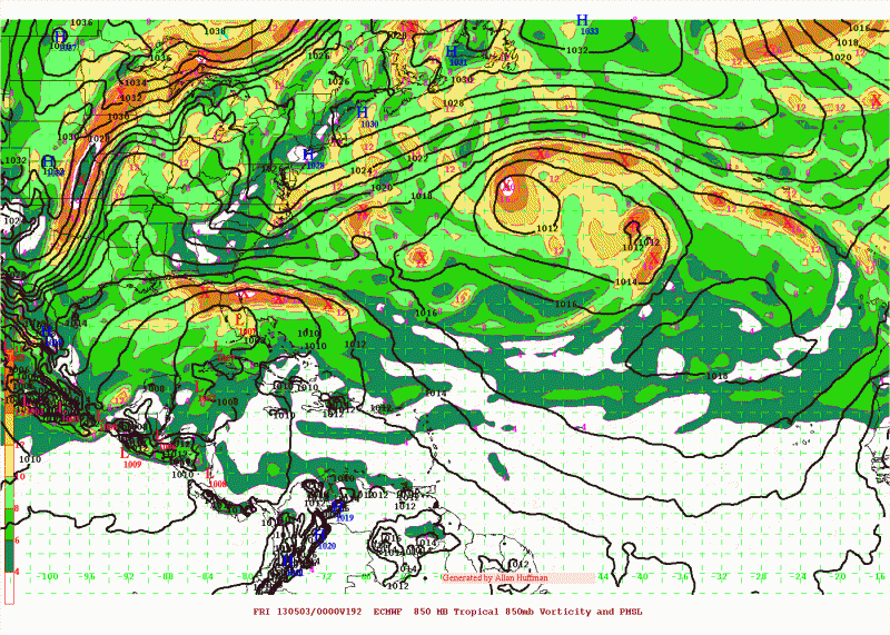
This is at hour 192 from the ECMWF. If it gets to 120 hours showing the same,then this will turn very interesting. But we have to see if the upper pattern will allow for a warm core low to form.

0 likes
Visit the Caribbean-Central America Weather Thread where you can find at first post web cams,radars
and observations from Caribbean basin members Click Here
and observations from Caribbean basin members Click Here
-
cycloneye
- Admin
- Posts: 149746
- Age: 69
- Joined: Thu Oct 10, 2002 10:54 am
- Location: San Juan, Puerto Rico
Re: Long range development possible (ATL)
http://forecast.weather.gov/product.php ... glossary=0
TUE-FRI...MIDDLE TO LATTER PART OF NEXT LOOKING INCREASINGLY WET AND
PERHAPS UNSETTLED. AMPLIFYING NORTHERN STREAM H50 TROUGH WILL KICK
ITS POS TILT PREDECESSOR SEWD ACROSS THE ERN GOMEX AND FL. SOME BIG
DIFFERENCES IN THE RESPONSE AT THE SURFACE AS THE RESULTANT PRESSURE
FALLS WILL BE DEPENDENT ON THE EXTENT AND ORGANIZATION OF THE MID
LEVEL TROUGH (CUTOFF LOW?) THAT MOVES OVERHEAD. THE 26/00Z GFS IS
WEAKER AND MORE PROGRESSIVE WITH THE SURFACE AND MID LEVEL FEATURES
COMPARED TO THE NEW ECM. THE LATTER`S SOLUTION IS OBVIOUSLY MUCH
MORE OMINOUS FOR THE FL EAST COAST...AS IT SHOWS A H50 CUTOFF OVHD
ABOUT 60M DEEPER...ALONG WITH A MUCH STRONGER (SUB-1000MB) SURFACE
LOW CENTER WHICH DROPS SSE RIGHT ALONG THE FL EAST COAST. THIS SOLN
WOULD BATTER THE NE FL COAST AND EVENTUALLY THE ENTIRETY OF THE FL
ATLC COAST WITH VERY STRONG N-NE FLOW FRI THROUGH SAT.
ESPECIALLY WORRISOME IS THE FACT THAT THE ECM HAS SHOWN A GENERAL
SOLUTION OF STRONGER SRN STREAM ENERGY (ALBEIT NOT QUITE TO THIS
EXTENT) FOR SEVERAL RUNS IN A ROW...AND IT USUALLY PERFORMS QUITE
WELL OVER THE CONUS. SUFFICE IT TO SAY...WE`LL BE KEEPING A CLOSE
EYE ON HOW THE MODEL GUIDANCE TRENDS OVER THE NEXT SEVERAL DAYS.
FOR NOW...HAVE SIDED WITH A MORE CONSERVATIVE SOLUTION WHICH SHOWS
CONTINUED INCREASE IN RAIN CHANCES THROUGH THU.
0 likes
Visit the Caribbean-Central America Weather Thread where you can find at first post web cams,radars
and observations from Caribbean basin members Click Here
and observations from Caribbean basin members Click Here
-
cycloneye
- Admin
- Posts: 149746
- Age: 69
- Joined: Thu Oct 10, 2002 10:54 am
- Location: San Juan, Puerto Rico
Re: Long range development possible (ATL)
Our friend Rob of Crownweather Services jumps in the discussion about this and says Subtropical possible.
http://www.crownweather.com/?p=7331
The various forecast guidance that I look at continues to show the very real possibility of a subtropical type storm to form near Florida’s East Coast by Thursday and Friday of next week bringing heavy rain and gusty winds to much of the Florida Peninsula late next week into possibly next weekend.
Looking at the particulars of each model: The European model forecasts that this system will develop near the eastern Gulf of Mexico very near Tampa on Thursday and then strengthen by Friday as it tracks eastward to a position just offshore of Cape Canaveral. The European model then forecasts this subtropical storm to track eastward across the northernmost Bahamas during next weekend.
The Canadian model guidance forecasts this subtropical system to develop near Great Abaco Island in the northernmost Bahamas on Thursday and then slowly track northeastward into the open Atlantic next weekend.
The NOGAPS model has this system developing near eastern North Carolina on Thursday and then slowly tracking north-northeastward along the Mid-Atlantic shoreline through next weekend. This scenario would lead to this system being non-tropical, but would still bring very heavy rainfall & gusty winds to much of the Mid-Atlantic states late next week into next weekend.
Here are my thoughts: The overall weather pattern from Wednesday of next week through next weekend will be one of strong high pressure building over New England which is actually a pattern that is favorable to look for some sort of tropical or subtropical development to the south of this high pressure system just off of the southeastern United States coast and this is what the guidance seems to be picking up on. With that said, it is not completely clear yet where exactly this storm system will form as there seems to be a range of possibilities from a development near Florida’s east coast to near eastern North Carolina. This large difference in possibilities will have a big impact on the possible effects from this storm as a development near Florida’s east coast would mean heavy rain and gusty winds for much of the Florida Peninsula and the northern Bahamas late next week into next weekend while development near eastern North Carolina would mean a heavy dousing of rain with gusty winds for much of the Mid-Atlantic states late next week into next weekend and Florida and the Bahamas would be spared.
At this point, I am leaning towards the idea of the development near Florida’s east coast as the overall pattern would support low pressure development here rather than further north up the coast. This is something that I will be keeping close tabs on over the next week and I will have additional posts as conditions warrant. For all our Crown Weather friends across the Florida Peninsula and the northern Bahamas, be aware that heavy rainfall with amounts of 2 to 3 inches and gusty east winds gusting to 40 mph are a possibility from Thursday through at least Saturday of next week.
0 likes
Visit the Caribbean-Central America Weather Thread where you can find at first post web cams,radars
and observations from Caribbean basin members Click Here
and observations from Caribbean basin members Click Here
-
northjaxpro

- S2K Supporter
- Posts: 8900
- Joined: Mon Sep 27, 2010 11:21 am
- Location: Jacksonville, FL
Re: Long range development possible (ATL)
0 likes
NEVER, EVER SAY NEVER in the tropics and weather in general, and most importantly, with life itself!!
________________________________________________________________________________________
Fay 2008 Beryl 2012 Debby 2012 Colin 2016 Hermine 2016 Julia 2016 Matthew 2016 Irma 2017 Dorian 2019
________________________________________________________________________________________
Fay 2008 Beryl 2012 Debby 2012 Colin 2016 Hermine 2016 Julia 2016 Matthew 2016 Irma 2017 Dorian 2019
Re: Long range development possible (ATL)
The Euro has been performing very well over the last few months when compared to the GFS.
It is forecasting for some sort of a hybrid broad low pressure to form in the eastern GOM within 144 hrs and start deepening within 168 hrs. Something to keep an eye on when it has been doing so well in its mid range forecast, I will be surprised if it does not verify.
I also think that it has a shot to acquired subtropical characteristics off the east coast of FL, where SSTs are above average.
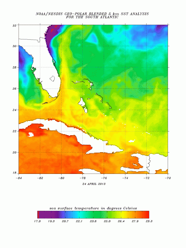
Is true that the water temps on coastal waters near Jacksonville are in the upper 60s but SSTs from central FL into the gulf stream on eastward the SSTs are in the mid to upper 70s, plenty warm for subtropical systems, IMO.
It is forecasting for some sort of a hybrid broad low pressure to form in the eastern GOM within 144 hrs and start deepening within 168 hrs. Something to keep an eye on when it has been doing so well in its mid range forecast, I will be surprised if it does not verify.
I also think that it has a shot to acquired subtropical characteristics off the east coast of FL, where SSTs are above average.
Is true that the water temps on coastal waters near Jacksonville are in the upper 60s but SSTs from central FL into the gulf stream on eastward the SSTs are in the mid to upper 70s, plenty warm for subtropical systems, IMO.
0 likes
-
northjaxpro
- S2K Supporter
- Posts: 8900
- Joined: Mon Sep 27, 2010 11:21 am
- Location: Jacksonville, FL
I agree NDG that SST's farther off shore would support a hybrid/STS development, no doubt about that.
0 likes
NEVER, EVER SAY NEVER in the tropics and weather in general, and most importantly, with life itself!!
________________________________________________________________________________________
Fay 2008 Beryl 2012 Debby 2012 Colin 2016 Hermine 2016 Julia 2016 Matthew 2016 Irma 2017 Dorian 2019
________________________________________________________________________________________
Fay 2008 Beryl 2012 Debby 2012 Colin 2016 Hermine 2016 Julia 2016 Matthew 2016 Irma 2017 Dorian 2019
-
cycloneye
- Admin
- Posts: 149746
- Age: 69
- Joined: Thu Oct 10, 2002 10:54 am
- Location: San Juan, Puerto Rico
Re: Long range development possible (ATL)
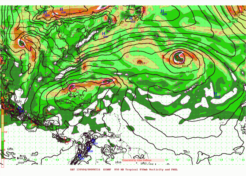
Hmmm, looks like a warm core on the 12z ECMWF?

0 likes
Visit the Caribbean-Central America Weather Thread where you can find at first post web cams,radars
and observations from Caribbean basin members Click Here
and observations from Caribbean basin members Click Here
-
wxman57
- Moderator-Pro Met
- Posts: 23175
- Age: 68
- Joined: Sat Jun 21, 2003 8:06 pm
- Location: Houston, TX (southwest)
Re: Long range development possible (ATL)
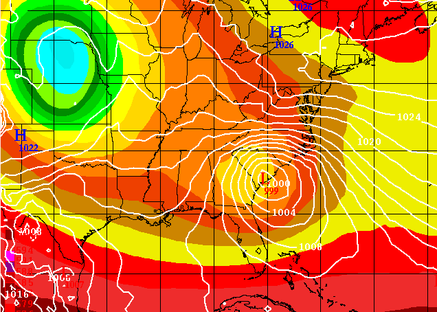
The low on the 12Z Euro appears to be frontal and beneath an upper low. Not much time over the water. I'd say chances of a named STS are low.
0 likes
-
MGC

- S2K Supporter
- Posts: 5941
- Joined: Sun Mar 23, 2003 9:05 pm
- Location: Pass Christian MS, or what is left.
Re: Long range development possible (ATL)
Seems like last year all over again, two frontal lows becoming tropical. We will have to see if this happens again this year. Hope not because I'm forecasting no early season activity this year....MGC
0 likes
-
floridasun78
- Category 5
- Posts: 3755
- Joined: Sun May 17, 2009 10:16 pm
- Location: miami fl
i here back a bit early i mostly post doing hurr season that almost here but i read crown post he talking maybe subtropical system by fl on thur nws office miami have back down a bit rain chance late next week but early friday it was in 40s now 30s so i think their waiting see if weather pan out but some thing i be watching because affect my job when rain my hour get cut i work lowes let see what run show by tue
0 likes
Re: Long range development possible (ATL)
Houston we have a problem, the Euro might be letting me down, lol.
The last couple of runs of the Euro has been retrograding to a solution of barely or no subtropical system developing, with last night's run not even showing it any more. The Euro's ensemble mean is closer to the GFS and the GFS's ensemble mean.
Last nigth's GFS shows a low pressure developing over FL and heading north towards the Carolinas but is frontal extratropical low pressure.
Which by the way the GFS shows lows in the upper 30s across northern FL next weekend.
0 likes
-
floridasun78
- Category 5
- Posts: 3755
- Joined: Sun May 17, 2009 10:16 pm
- Location: miami fl
Re: Long range development possible (ATL)
this time of year model do alot ghost storms so i not supprise it not on it any more i bet their put new data show no system
0 likes


I've been following the models on this feature. Too much cold air around, if the trough pinches off there's a slight chance of a brief hybrid reflection but even that doesn't look too good. Most likely a winter-like coastal storm at best as Alyono mentioned.
0 likes
The above post and any post by Ntxw is NOT an official forecast and should not be used as such. It is just the opinion of the poster and may or may not be backed by sound meteorological data. It is NOT endorsed by any professional institution including Storm2k. For official information, please refer to NWS products.
Help support Storm2K!

Re: Long range development possible (ATL)
NDG wrote:Which by the way the GFS shows lows in the upper 30s across northern FL next weekend.
0 likes
Who is online
Users browsing this forum: No registered users and 254 guests