Early June Development in WCarib or BOC? (Is Invest 91L)

This is the general tropical discussion area. Anyone can take their shot at predicting a storms path.

Moderator: S2k Moderators

Forum rules

The posts in this forum are NOT official forecasts and should not be used as such. They are just the opinion of the poster and may or may not be backed by sound meteorological data. They are NOT endorsed by any professional institution or STORM2K. For official information, please refer to products from the National Hurricane Center and National Weather Service.

Help Support Storm2K
Message
Author
User avatar
TropicalAnalystwx13
Category 5
Category 5
Posts: 2109
Age: 28
Joined: Tue Jul 19, 2011 8:20 pm
Location: Wilmington, NC
Contact:

Early June Development in WCarib or BOC? (Is Invest 91L)

#1 Postby TropicalAnalystwx13 » Thu May 09, 2013 5:27 pm

The strong MJO pulse responsible for the [soon-to-be] twin cyclones in the Indian Ocean (one in the northern hemisphere, one in the southern hemisphere) is forecast to steadily work its way through the Maritime Continent, West Pacific, and eventually reach Octants 8/1 (West Hemisphere, Atlantic/East Pacific) by the end of the month. Many of the global computer models—especially the GFS—are hinting at lowering pressures across the eastern Pacific and western Caribbean. The CMC shows "Alvin" developing in a little over a week's time now, while the GFS ensembles have a low-pressure center in the western Caribbean by the end of their runs. While specifics -- intensity, track, etc -- are obviously unknown, MJO pulses in the early season make up over three-quarters of the cyclone development method. One of this magnitude means it's likely we see "Alvin" and "Andrea" by the end of the first week of June, if not sooner.

Image
Image
Image
Last edited by cycloneye on Sun Jun 02, 2013 9:29 pm, edited 5 times in total.
Reason: Edited title to modify it
0 likes   

User avatar
Ntxw
Storm2k Moderator
Storm2k Moderator
Posts: 22786
Joined: Wed Oct 21, 2009 6:34 pm
Location: DFW, Texas

#2 Postby Ntxw » Thu May 09, 2013 8:42 pm

I concur with everything TropicalAnalystwx13 said. This is a very strong MJO well supported by the recent mountain torque event and suspect the models are not handling well yet the progression of it beyond the western Pacific. Monsoon-like areas of convection will likely awaken on either side of Central America later this month. The last of the Canadian highs will settle over the eastern US and set up nice return/moist flow into the carib-southern gulf regions likely reducing shear and various other factors that so far have prevented formation of early season systems.
0 likes   
The above post and any post by Ntxw is NOT an official forecast and should not be used as such. It is just the opinion of the poster and may or may not be backed by sound meteorological data. It is NOT endorsed by any professional institution including Storm2k. For official information, please refer to NWS products.

  Help support Storm2K!
Help Support Storm2K

JonathanBelles
Professional-Met
Professional-Met
Posts: 11430
Age: 35
Joined: Sat Dec 24, 2005 9:00 pm
Location: School: Florida State University (Tallahassee, FL) Home: St. Petersburg, Florida
Contact:

Re:

#3 Postby JonathanBelles » Thu May 09, 2013 9:47 pm

Ntxw wrote:I concur with everything TropicalAnalystwx13 said. This is a very strong MJO well supported by the recent mountain torque event and suspect the models are not handling well yet the progression of it beyond the western Pacific. Monsoon-like areas of convection will likely awaken on either side of Central America later this month. The last of the Canadian highs will settle over the eastern US and set up nice return/moist flow into the carib-southern gulf regions likely reducing shear and various other factors that so far have prevented formation of early season systems.


What do you mean by the highlighted portion above?
0 likes   

User avatar
crownweather
S2K Supporter
S2K Supporter
Posts: 595
Age: 50
Joined: Sat Aug 12, 2006 9:21 am
Location: Sturbridge, Massachusetts
Contact:

Re: Late May development likely

#4 Postby crownweather » Fri May 10, 2013 4:08 am

Latest GFS now gets our low pressure system going at about 300 hours. My opinion is that it may be about a week too fast & think that any tropical development may hold off until just after Memorial Day instead of the time period just before Memorial Day.
0 likes   
Rob Lightbown
Crown Weather Services
https://crownweather.com

kunosoura
S2K Supporter
S2K Supporter
Posts: 29
Joined: Thu Sep 08, 2011 11:23 am
Location: Jupiter

Re: Late May development likely

#5 Postby kunosoura » Fri May 10, 2013 8:06 am

00z GFS still supporting Caribbean action starting May 22ish.

Image

Uploaded with ImageShack.us
0 likes   

User avatar
cycloneye
Admin
Admin
Posts: 145364
Age: 68
Joined: Thu Oct 10, 2002 10:54 am
Location: San Juan, Puerto Rico

Re: Late May development likely

#6 Postby cycloneye » Fri May 10, 2013 10:45 am

This is from Dr Jeff Masters:

It's worth mentioning that the active pulse of the Madden Julian Oscillation is expected to reach the Western Caribbean sometime May 22 - 26, and there will be a heightened chance of an early-season tropical storm forming in the Eastern Pacific and Western Caribbean during that time period.
0 likes   
Visit the Caribbean-Central America Weather Thread where you can find at first post web cams,radars
and observations from Caribbean basin members Click Here

User avatar
cycloneye
Admin
Admin
Posts: 145364
Age: 68
Joined: Thu Oct 10, 2002 10:54 am
Location: San Juan, Puerto Rico

Re: Late May development likely

#7 Postby cycloneye » Fri May 10, 2013 1:12 pm

I would use a blend of faster GFS vs slower ECMWF and get the timeframe shorter than 144 hours to then join the developing bandwagon. For entertainment here is the long range GFS.

Image

Image
0 likes   
Visit the Caribbean-Central America Weather Thread where you can find at first post web cams,radars
and observations from Caribbean basin members Click Here

User avatar
Ntxw
Storm2k Moderator
Storm2k Moderator
Posts: 22786
Joined: Wed Oct 21, 2009 6:34 pm
Location: DFW, Texas

Re: Re:

#8 Postby Ntxw » Fri May 10, 2013 1:32 pm

JonathanBelles wrote:What do you mean by the highlighted portion above?


This MJO wave is being enhanced (as is with most strong waves) by westerlies that have recently been aided by the mountain torque events (+AAM). Two things usually happens as a result, first is the wave is stronger than what the models predicted a couple of weeks ago and second the MJO is very likely to continue its progression into the western hemisphere instead of weakening once it crosses the Pacific into the Americas as it usually does due to these enhanced westerlies as currently being forecasted by the globals.

Image

Image

As you can see the MJO is most active when MT events are given off to positive territory.
0 likes   
The above post and any post by Ntxw is NOT an official forecast and should not be used as such. It is just the opinion of the poster and may or may not be backed by sound meteorological data. It is NOT endorsed by any professional institution including Storm2k. For official information, please refer to NWS products.


  Help support Storm2K!

Help Support Storm2K


tolakram
Admin
Admin
Posts: 20010
Age: 62
Joined: Sun Aug 27, 2006 8:23 pm
Location: Florence, KY (name is Mark)

Re: Late May development likely

#9 Postby tolakram » Fri May 10, 2013 1:49 pm

Every year we get the GFS telling us of development in the southwest Caribbean in mid to late May. IMO this is most likely the first or second EPAC storm.

The posts in this forum are NOT official forecast and should not be used as such. They are just the opinion of the poster and may or may not be backed by sound meteorological data. They are NOT endorsed by any professional institution or storm2k.org. For official information, please refer to the NHC and NWS products.
0 likes   
M a r k
- - - - -
Join us in chat: Storm2K Chatroom Invite. Android and IOS apps also available.

The posts in this forum are NOT official forecasts and should not be used as such. Posts are NOT endorsed by any professional institution or STORM2K.org. For official information and forecasts, please refer to NHC and NWS products.

User avatar
cycloneye
Admin
Admin
Posts: 145364
Age: 68
Joined: Thu Oct 10, 2002 10:54 am
Location: San Juan, Puerto Rico

Re: Late May development likely

#10 Postby cycloneye » Fri May 10, 2013 2:15 pm

tolakram wrote:Every year we get the GFS telling us of development in the southwest Caribbean in mid to late May. IMO this is most likely the first or second EPAC storm.

The posts in this forum are NOT official forecast and should not be used as such. They are just the opinion of the poster and may or may not be backed by sound meteorological data. They are NOT endorsed by any professional institution or storm2k.org. For official information, please refer to the NHC and NWS products.


GEM aka CMC was the first model to sniff development in EPAC a few days ago and now GFS and to some extent the ECMWF are showing it.

Image

Image

Image
0 likes   
Visit the Caribbean-Central America Weather Thread where you can find at first post web cams,radars
and observations from Caribbean basin members Click Here

WeatherGuesser
Category 5
Category 5
Posts: 2672
Joined: Tue Jun 29, 2010 6:46 am

#11 Postby WeatherGuesser » Fri May 10, 2013 2:31 pm

So far, none of these threads have worked out as touted. I really wish we'd hold off on the long range dramatics and wait until there's something relevant to talk about.
0 likes   

Frank2
Category 5
Category 5
Posts: 4061
Joined: Mon Jul 25, 2005 12:47 pm

Re: Late May development likely

#12 Postby Frank2 » Fri May 10, 2013 2:48 pm

I'd have to agree - right now we have very strong shear over Florida, so anything that did form would end up a exposed LLC...

A lot would have to change for it to become an issue for the USA, however those who live in Central America, Jamacia or Cuba might need to be prepared as the month progresses, just in case...

Frank2
0 likes   

User avatar
TropicalAnalystwx13
Category 5
Category 5
Posts: 2109
Age: 28
Joined: Tue Jul 19, 2011 8:20 pm
Location: Wilmington, NC
Contact:

Re: Late May development likely

#13 Postby TropicalAnalystwx13 » Fri May 10, 2013 6:18 pm

tolakram wrote:Every year we get the GFS telling us of development in the southwest Caribbean in mid to late May. IMO this is most likely the first or second EPAC storm.

The posts in this forum are NOT official forecast and should not be used as such. They are just the opinion of the poster and may or may not be backed by sound meteorological data. They are NOT endorsed by any professional institution or storm2k.org. For official information, please refer to the NHC and NWS products.

The model probably didn't have much consistency between runs. It makes sense to see a tropical cyclone in the Caribbean by the first of June. Strong MJO pulse with high pressure over the Eastern Seaboard. The CMC has above-average precipitation in the region as well, which gives the solution a bit more credence.

Frank2 wrote:I'd have to agree - right now we have very strong shear over Florida, so anything that did form would end up a exposed LLC...

A lot would have to change for it to become an issue for the USA, however those who live in Central America, Jamacia or Cuba might need to be prepared as the month progresses, just in case...

Frank2

It doesn't take much to lower wind shear. An anticyclone over any system in the western Caribbean would dramatically lessen the shear values.
0 likes   

User avatar
TropicalAnalystwx13
Category 5
Category 5
Posts: 2109
Age: 28
Joined: Tue Jul 19, 2011 8:20 pm
Location: Wilmington, NC
Contact:

#14 Postby TropicalAnalystwx13 » Fri May 10, 2013 6:20 pm

18z GFS.

Image

Image
0 likes   

psyclone
S2K Supporter
S2K Supporter
Posts: 4762
Joined: Wed Aug 24, 2005 9:04 pm
Location: palm harbor fl

#15 Postby psyclone » Fri May 10, 2013 9:44 pm

absent some sat pics showing some disturbed weather (the carib is clear) this really is a modelstorm thread.
0 likes   

User avatar
gatorcane
S2K Supporter
S2K Supporter
Posts: 23691
Age: 47
Joined: Sun Mar 13, 2005 3:54 pm
Location: Boca Raton, FL

#16 Postby gatorcane » Fri May 10, 2013 10:19 pm

Below graphic bottom row shows essentially what others have been saying regarding the potential for a strong MJO pulse across the Western Caribbean for the end of the month:

Image
0 likes   

psyclone
S2K Supporter
S2K Supporter
Posts: 4762
Joined: Wed Aug 24, 2005 9:04 pm
Location: palm harbor fl

#17 Postby psyclone » Fri May 10, 2013 10:37 pm

this set up would seem to imply at least northerly advection of deep caribbean moisture to jump start the florida rainy season.
0 likes   

JonathanBelles
Professional-Met
Professional-Met
Posts: 11430
Age: 35
Joined: Sat Dec 24, 2005 9:00 pm
Location: School: Florida State University (Tallahassee, FL) Home: St. Petersburg, Florida
Contact:

Re:

#18 Postby JonathanBelles » Fri May 10, 2013 10:37 pm

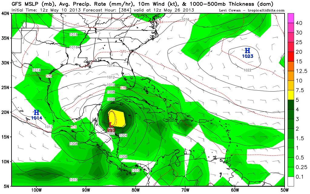
gatorcane wrote:Below graphic bottom row shows essentially what others have been saying regarding the potential for a strong MJO pulse across the Western Caribbean for the end of the month:

Image Omitted


Wow! I don't think I have seen white on the "wet" side of the scale before.
0 likes   

psyclone
S2K Supporter
S2K Supporter
Posts: 4762
Joined: Wed Aug 24, 2005 9:04 pm
Location: palm harbor fl

#19 Postby psyclone » Fri May 10, 2013 10:39 pm

I've never seen the white either...only a dark green max out. and it's a big area too.
0 likes   

User avatar
cycloneye
Admin
Admin
Posts: 145364
Age: 68
Joined: Thu Oct 10, 2002 10:54 am
Location: San Juan, Puerto Rico

Re: Late May Development Likely

#20 Postby cycloneye » Sat May 11, 2013 7:04 am

Well,GFS is dancing around as the 00z run only had a weak TD instead of a Tropical Storm and the 06Z run had a Tropical Storm. And also still no other models are showing it as of Saturday morning so there is a big deal of uncertainty at this time. Let's see how things evolve in the model world in the coming days.
0 likes   
Visit the Caribbean-Central America Weather Thread where you can find at first post web cams,radars
and observations from Caribbean basin members Click Here


Return to “Talkin' Tropics”

Who is online

Users browsing this forum: cheezyWXguy and 37 guests