2021 Tropical Waves Thread
Moderator: S2k Moderators
Forum rules

The posts in this forum are NOT official forecasts and should not be used as such. They are just the opinion of the poster and may or may not be backed by sound meteorological data. They are NOT endorsed by any professional institution or STORM2K. For official information, please refer to products from the National Hurricane Center and National Weather Service.
-
Aric Dunn
- Category 5

- Posts: 21238
- Age: 43
- Joined: Sun Sep 19, 2004 9:58 pm
- Location: Ready for the Chase.
- Contact:
Tropical Wave east of the Lesser Antilles
Convection on the increase, Marginal short term/Long term models support. Besides SAL far to the north, the environment for the next 48 hours looks good. Afterward, western carrib development appears to be a decent probability.
Last edited by Aric Dunn on Sun Jun 20, 2021 6:50 pm, edited 1 time in total.
1 likes
Note: If I make a post that is brief. Please refer back to previous posts for the analysis or reasoning. I do not re-write/qoute what my initial post said each time.
If there is nothing before... then just ask
Space & Atmospheric Physicist, Embry-Riddle Aeronautical University,
I believe the sky is falling...
If there is nothing before... then just ask
Space & Atmospheric Physicist, Embry-Riddle Aeronautical University,
I believe the sky is falling...
-
Ivanhater

- Storm2k Moderator

- Posts: 11222
- Age: 39
- Joined: Fri Jul 01, 2005 8:25 am
- Location: Pensacola
Re: Tropical Wave east of the Lesser Antilles
Watching this closely. Just don't be anywhere near Orlando July 5-11 while I'm on vacation 
This looks to be a bit before that time though. GFS has been consistent on development.
This looks to be a bit before that time though. GFS has been consistent on development.
2 likes
Michael
-
Aric Dunn
- Category 5
- Posts: 21238
- Age: 43
- Joined: Sun Sep 19, 2004 9:58 pm
- Location: Ready for the Chase.
- Contact:
Re: Tropical Wave east of the Lesser Antilles
Ivanhater wrote:Watching this closely. Just don't be anywhere near Orlando July 5-11 while I'm on vacation
This looks to be a bit before that time though. GFS has been consistent on development.
Euro and the EPS have been showing this developing before the islands as well.
1 likes
Note: If I make a post that is brief. Please refer back to previous posts for the analysis or reasoning. I do not re-write/qoute what my initial post said each time.
If there is nothing before... then just ask
Space & Atmospheric Physicist, Embry-Riddle Aeronautical University,
I believe the sky is falling...
If there is nothing before... then just ask
Space & Atmospheric Physicist, Embry-Riddle Aeronautical University,
I believe the sky is falling...
-
Kingarabian

- S2K Supporter

- Posts: 16379
- Joined: Sat Aug 08, 2009 3:06 am
- Location: Honolulu, Hawaii
Re: Tropical Wave east of the Lesser Antilles
Possible we see something similar or stronger than Cindy 2017.

For development, main thing it deepens a little as it enters the Caribbean so it' can gain some latitude. Or else it can easily crash into CA, develop over the BOC, and into western Mexico. Also possible it doesn't get deep enough and ends up in the EPAC where it could die or develop later on.
For development, main thing it deepens a little as it enters the Caribbean so it' can gain some latitude. Or else it can easily crash into CA, develop over the BOC, and into western Mexico. Also possible it doesn't get deep enough and ends up in the EPAC where it could die or develop later on.
0 likes
RIP Kobe Bryant
-
Aric Dunn
- Category 5
- Posts: 21238
- Age: 43
- Joined: Sun Sep 19, 2004 9:58 pm
- Location: Ready for the Chase.
- Contact:
Re: Tropical Wave east of the Lesser Antilles
There is a distinct possibility we see this first spin up in the next couple of days prior to entering the carrib.
Before sunset there was a clear low level vort max and now there is a developing burst of deep convection right over it.
Shear is low and its in a deep moisture pouch.
If it does develop before the islands. it would possibly weaken until western carrib.
Before sunset there was a clear low level vort max and now there is a developing burst of deep convection right over it.
Shear is low and its in a deep moisture pouch.
If it does develop before the islands. it would possibly weaken until western carrib.
0 likes
Note: If I make a post that is brief. Please refer back to previous posts for the analysis or reasoning. I do not re-write/qoute what my initial post said each time.
If there is nothing before... then just ask
Space & Atmospheric Physicist, Embry-Riddle Aeronautical University,
I believe the sky is falling...
If there is nothing before... then just ask
Space & Atmospheric Physicist, Embry-Riddle Aeronautical University,
I believe the sky is falling...
-
Aric Dunn
- Category 5
- Posts: 21238
- Age: 43
- Joined: Sun Sep 19, 2004 9:58 pm
- Location: Ready for the Chase.
- Contact:
Re: Tropical Wave east of the Lesser Antilles
New ASCAT. Several WSW wind barbs. For a small system that is pretty good for ASCAT. .. Marcos last year ASCAT had real hard time closing it off.. Convection appears to be increasing in intensity and slowly expanding.. if that occurs throughout the night tomorrow will be interesting.

2 likes
Note: If I make a post that is brief. Please refer back to previous posts for the analysis or reasoning. I do not re-write/qoute what my initial post said each time.
If there is nothing before... then just ask
Space & Atmospheric Physicist, Embry-Riddle Aeronautical University,
I believe the sky is falling...
If there is nothing before... then just ask
Space & Atmospheric Physicist, Embry-Riddle Aeronautical University,
I believe the sky is falling...
-
cycloneye

- Admin

- Posts: 149730
- Age: 69
- Joined: Thu Oct 10, 2002 10:54 am
- Location: San Juan, Puerto Rico
Re: Tropical Wave east of the Lesser Antilles


9 likes
Visit the Caribbean-Central America Weather Thread where you can find at first post web cams,radars
and observations from Caribbean basin members Click Here
and observations from Caribbean basin members Click Here
-
Stormybajan

- Category 1

- Posts: 453
- Joined: Thu May 20, 2021 3:21 pm
- Location: Windward Islands
Re: Tropical Wave east of the Lesser Antilles
Aric Dunn wrote:New ASCAT. Several WSW wind barbs. For a small system that is pretty good for ASCAT. .. Marcos last year ACAT had real hard time closing it off.. Convection appears to be increasing in intensity and slowly expanding.. if that occurs throughout the night tomorrow will be interesting.
https://i.ibb.co/G7WjpFC/Capture.png
Hmmmmmm interesting indeed, its certainly trying with the burst of convection occurring right now maybe if the 00z model runs show development or increase in vorticity maybe we get a yellow X tomorrow?
2 likes
Sad West Indies and Manchester United fan ⚽️
-
Kingarabian
- S2K Supporter
- Posts: 16379
- Joined: Sat Aug 08, 2009 3:06 am
- Location: Honolulu, Hawaii
Re: Tropical Wave east of the Lesser Antilles
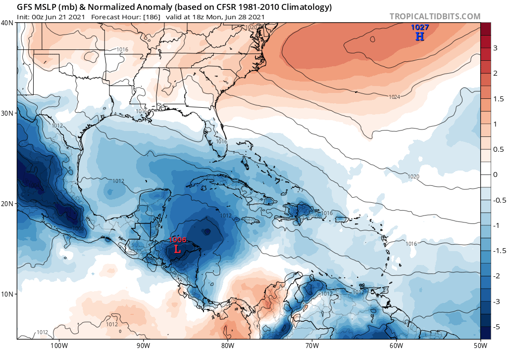
Could see development later on in the run but looks to be more CA interaction so far:
1 likes
RIP Kobe Bryant
-
Hurricaneman

- Category 5
- Posts: 7404
- Age: 45
- Joined: Tue Aug 31, 2004 3:24 pm
- Location: central florida
Re: Tropical Wave east of the Lesser Antilles
Kingarabian wrote:Could see development later on in the run but looks to be more CA interaction so far:
https://i.postimg.cc/02ggLKBF/image.png
I’m wondering if this is ex94L
0 likes
-
Aric Dunn
- Category 5
- Posts: 21238
- Age: 43
- Joined: Sun Sep 19, 2004 9:58 pm
- Location: Ready for the Chase.
- Contact:
Re: Tropical Wave east of the Lesser Antilles
Hurricaneman wrote:Kingarabian wrote:Could see development later on in the run but looks to be more CA interaction so far:
https://i.postimg.cc/02ggLKBF/image.png
I’m wondering if this is ex94L
it is not 94L ..
and development in western carrib would not be a CAG setup.
and development before islands is looking like a pretty good possibility right now... especially if convection continues through the night and tomorrow.
1 likes
Note: If I make a post that is brief. Please refer back to previous posts for the analysis or reasoning. I do not re-write/qoute what my initial post said each time.
If there is nothing before... then just ask
Space & Atmospheric Physicist, Embry-Riddle Aeronautical University,
I believe the sky is falling...
If there is nothing before... then just ask
Space & Atmospheric Physicist, Embry-Riddle Aeronautical University,
I believe the sky is falling...
-
Nancy Smar

- Category 5
- Posts: 1081
- Age: 25
- Joined: Wed Aug 16, 2017 10:03 pm
Re: Tropical Wave east of the Lesser Antilles
ABNT20 KNHC 210531
TWOAT
Tropical Weather Outlook
NWS National Hurricane Center Miami FL
200 AM EDT Mon Jun 21 2021
For the North Atlantic...Caribbean Sea and the Gulf of Mexico:
The National Hurricane Center is issuing advisories on Tropical
Depression Claudette, located inland over North Carolina.
A tropical wave located about 1000 miles east of the Windward
Islands is producing a small area of thunderstorm activity. This
system has a slight chance of development during the next couple of
days before upper-level winds become less conducive for further
organization by Thursday. The wave is expected to move westward at
10 to 15 mph.
* Formation chance through 48 hours...low...10 percent.
* Formation chance through 5 days...low...10 percent.
$$
Forecaster Blake
4 likes
-
Stormybajan
- Category 1
- Posts: 453
- Joined: Thu May 20, 2021 3:21 pm
- Location: Windward Islands
Re: Tropical Wave east of the Lesser Antilles
Stormybajan wrote:Aric Dunn wrote:New ASCAT. Several WSW wind barbs. For a small system that is pretty good for ASCAT. .. Marcos last year ACAT had real hard time closing it off.. Convection appears to be increasing in intensity and slowly expanding.. if that occurs throughout the night tomorrow will be interesting.
https://i.ibb.co/G7WjpFC/Capture.png
Hmmmmmm interesting indeed, its certainly trying with the burst of convection occurring right now maybe if the 00z model runs show development or increase in vorticity maybe we get a yellow X tomorrow?
Yellow X it is
1 likes
Sad West Indies and Manchester United fan ⚽️
-
USTropics
- Professional-Met

- Posts: 2741
- Joined: Sun Aug 12, 2007 3:45 am
- Location: Florida State University
Re: Tropical Wave east of the Lesser Antilles
Here is a rough estimate of observed tropical waves in the ATL/EPAC and their progression over the next 192 hours (first image has outlined ITCZ in green):

6 likes

-
catskillfire51
- S2K Supporter
- Posts: 480
- Age: 39
- Joined: Sun Aug 26, 2012 5:40 pm
- Location: Lake Jackson, TX
-
Nancy Smar
- Category 5
- Posts: 1081
- Age: 25
- Joined: Wed Aug 16, 2017 10:03 pm
Re: Tropical Wave east of the Lesser Antilles
GENESIS007, AL, L, , , , , 77, 2021, DB, O, 2021062106, 9999999999, , 007, , , , GENESIS, , AL772021
0 likes
-
cycloneye
- Admin
- Posts: 149730
- Age: 69
- Joined: Thu Oct 10, 2002 10:54 am
- Location: San Juan, Puerto Rico
Re: Tropical Wave east of the Lesser Antilles
Nancy Smar wrote:GENESIS007, AL, L, , , , , 77, 2021, DB, O, 2021062106, 9999999999, , 007, , , , GENESIS, , AL772021
Invest comming soon.
1 likes
Visit the Caribbean-Central America Weather Thread where you can find at first post web cams,radars
and observations from Caribbean basin members Click Here
and observations from Caribbean basin members Click Here

Re: Tropical Wave east of the Lesser Antilles
This actually looks pretty good. If it does form, we’ll have to watch out for sudden RI due to its small size, perhaps similar to Beryl, Dorian, and the previous Danny. The NHC says it’ll be within conditions favorable for development until Thursday, which could be enough time for this to become a decent TS.
We might have to watch what it does beyond the Lesser Antilles. Is this the wave that helps spawn the WCar/Gulf system the GFS has been showing for the last few days?
We might have to watch what it does beyond the Lesser Antilles. Is this the wave that helps spawn the WCar/Gulf system the GFS has been showing for the last few days?
1 likes
Irene '11 Sandy '12 Hermine '16 5/15/2018 Derecho Fay '20 Isaias '20 Elsa '21 Henri '21 Ida '21
I am only a meteorology enthusiast who knows a decent amount about tropical cyclones. Look to the professional mets, the NHC, or your local weather office for the best information.
I am only a meteorology enthusiast who knows a decent amount about tropical cyclones. Look to the professional mets, the NHC, or your local weather office for the best information.
-
catskillfire51
- S2K Supporter
- Posts: 480
- Age: 39
- Joined: Sun Aug 26, 2012 5:40 pm
- Location: Lake Jackson, TX
Re: Tropical Wave east of the Lesser Antilles
Yes it is.
aspen wrote:This actually looks pretty good. If it does form, we’ll have to watch out for sudden RI due to its small size, perhaps similar to Beryl, Dorian, and the previous Danny. The NHC says it’ll be within conditions favorable for development until Thursday, which could be enough time for this to become a decent TS.
We might have to watch what it does beyond the Lesser Antilles. Is this the wave that helps spawn the WCar/Gulf system the GFS has been showing for the last few days?
0 likes
Who is online
Users browsing this forum: gib, hurricanes1234 and 114 guests