
06 GFS has a hit on Maine /+/- 300 hours with a tropical system forming in the subtropics and getting lassoed by a low pressure system that brings it in. Not buying it now but if it was September you could see that.
https://www.tropicaltidbits.com/analysi ... 1906&fh=54
2022 Global Model Runs Discussion (Out thru day 16)
Moderator: S2k Moderators
Forum rules

The posts in this forum are NOT official forecasts and should not be used as such. They are just the opinion of the poster and may or may not be backed by sound meteorological data. They are NOT endorsed by any professional institution or STORM2K. For official information, please refer to products from the National Hurricane Center and National Weather Service.
-
cycloneye

- Admin

- Posts: 139202
- Age: 67
- Joined: Thu Oct 10, 2002 10:54 am
- Location: San Juan, Puerto Rico
Re: 2022 Global Model Runs Discussion (Out thru day 16)
0 likes
Visit the Caribbean-Central America Weather Thread where you can find at first post web cams,radars
and observations from Caribbean basin members Click Here
and observations from Caribbean basin members Click Here
-
skyline385

- Category 5

- Posts: 2465
- Age: 33
- Joined: Wed Aug 26, 2020 11:15 pm
- Location: Houston TX
Re: 2022 Global Model Runs Discussion (Out thru day 16)
aspen wrote:The Euro, CMC, and ICON all try to develop a wave that emerges off of Africa around August 24th. This is one of the two waves the GFS developed into MDR storms back when it was actually showing any Atlantic development.
All of them also have the wave at similar locations, its been a while since we have seen that happen on multiple models.
0 likes
-
SconnieCane
- Category 4

- Posts: 913
- Joined: Thu Aug 02, 2018 5:29 pm
- Location: Madison, WI
Re: 2022 Global Model Runs Discussion (Out thru day 16)
skyline385 wrote:aspen wrote:The Euro, CMC, and ICON all try to develop a wave that emerges off of Africa around August 24th. This is one of the two waves the GFS developed into MDR storms back when it was actually showing any Atlantic development.
All of them also have the wave at similar locations, its been a while since we have seen that happen on multiple models.
Of course this would happen as soon as the GFS/GEFS effectively drops development with it.
0 likes
-
Kingarabian

- S2K Supporter

- Posts: 15445
- Joined: Sat Aug 08, 2009 3:06 am
- Location: Honolulu, Hawaii
Re: 2022 Global Model Runs Discussion (Out thru day 16)
Even though the GFS bas dropped the idea of another GOM of system in the next 10 days, the 00z CMC still has it and it's very pronounced on the model.
0 likes
RIP Kobe Bryant
-
SFLcane

- S2K Supporter
- Posts: 9615
- Age: 46
- Joined: Sat Jun 05, 2010 1:44 pm
- Location: Lake Worth Florida
Re: 2022 Global Model Runs Discussion (Out thru day 16)
Models waking up? Icon showing development luckly with a big trough pinching off in front of it which turns it nw pretty quickly.
0 likes
Re: 2022 Global Model Runs Discussion (Out thru day 16)
Hmm 12z GFS sees something developing Monday near the Azores now (the one talked about in the "Tropical Wave off the African coast" thread)... what is up with models lately?
0 likes
-
AutoPenalti
- Category 5
- Posts: 3949
- Age: 27
- Joined: Mon Aug 17, 2015 4:16 pm
- Location: Ft. Lauderdale, Florida
Re: 2022 Global Model Runs Discussion (Out thru day 16)
GFS 12z has something interesting at day 5...
0 likes
The posts in this forum are NOT official forecasts and should not be used as such. They are just the opinion of the poster and may or may not be backed by sound meteorological data. They are NOT endorsed by any professional institution or STORM2K. For official information, please refer to products from the NHC and NWS.
Model Runs Cheat Sheet:
GFS (5:30 AM/PM, 11:30 AM/PM)
HWRF, GFDL, UKMET, NAVGEM (6:30-8:00 AM/PM, 12:30-2:00 AM/PM)
ECMWF (1:45 AM/PM)
TCVN is a weighted averaged
-
Blown Away

- S2K Supporter
- Posts: 9863
- Joined: Wed May 26, 2004 6:17 am
Re: 2022 Global Model Runs Discussion (Out thru day 16)
AutoPenalti wrote:GFS 12z has something interesting at day 5...
Same TW/low on the 8.17.22 GFS runs that generated all those ensemble MH hits in the Bahamas, Florida, NGOM...
2 likes
Hurricane Eye Experience: David 79, Irene 99, Frances 04, Jeanne 04, Wilma 05...
Hurricane Brush Experience: Andrew 92, Erin 95, Floyd 99, Matthew 16, Irma 17, Ian 22, Nicole 22…
Hurricane Brush Experience: Andrew 92, Erin 95, Floyd 99, Matthew 16, Irma 17, Ian 22, Nicole 22…
-
Kingarabian
- S2K Supporter
- Posts: 15445
- Joined: Sat Aug 08, 2009 3:06 am
- Location: Honolulu, Hawaii
Re: 2022 Global Model Runs Discussion (Out thru day 16)
GFS back to showing the medium range GOM system.
2 likes
RIP Kobe Bryant
Re: 2022 Global Model Runs Discussion (Out thru day 16)
Meanwhile, the 12Z UKMET is the first with a TC on it in many days and the first on any UKMET run in the MDR since even further back/probably weeks. This is NOT the same AEW just discussed in the thread for the AEW already offshore as regards the GFS (UK has yet to touch that one on any run) but rather is a later one not coming off Africa for a few more days:
NEW TROPICAL CYCLONE FORECAST TO DEVELOP AFTER 120 HOURS
FORECAST POSITION AT T+120 : 15.2N 18.0W
LEAD CENTRAL MAXIMUM WIND
VERIFYING TIME TIME POSITION PRESSURE (MB) SPEED (KNOTS)
-------------- ---- -------- ------------- -------------
1200UTC 24.08.2022 120 15.2N 18.0W 1004 32
0000UTC 25.08.2022 132 16.4N 20.1W 1007 26
1200UTC 25.08.2022 144 16.6N 23.0W 1006 27
Last edited by LarryWx on Fri Aug 19, 2022 11:44 am, edited 1 time in total.
4 likes
Personal Forecast Disclaimer:
The posts in this forum are NOT official forecasts and should not be used as such. They are just the opinion of the poster and may or may not be backed by sound meteorological data. They are NOT endorsed by any professional institution or storm2k.org. For official information, please refer to the NHC and NWS products.
The posts in this forum are NOT official forecasts and should not be used as such. They are just the opinion of the poster and may or may not be backed by sound meteorological data. They are NOT endorsed by any professional institution or storm2k.org. For official information, please refer to the NHC and NWS products.
-
lsuhurricane
- Tropical Storm

- Posts: 208
- Joined: Tue Aug 15, 2017 2:53 pm
Re: 2022 Global Model Runs Discussion (Out thru day 16)
Yep, back to both CMC and GFS indicating a GOM threat late next week.
Both also showing the next wave developing, albeit at differing speeds.
Both also showing the next wave developing, albeit at differing speeds.
1 likes

Re: 2022 Global Model Runs Discussion (Out thru day 16)
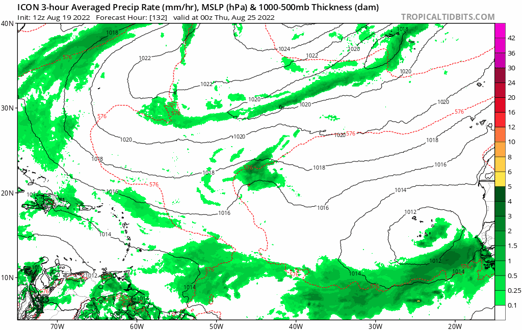
The 12z CMC is even stronger with the system spawned from the 8/24 wave. 12z ICON still develops it.
The favored wave on the GFS remains weak before starting to develop near the Caribbean on the 12z run. I can pick out that same wave on the CMC, but it never develops and runs over the Shredder.
The favored wave on the GFS remains weak before starting to develop near the Caribbean on the 12z run. I can pick out that same wave on the CMC, but it never develops and runs over the Shredder.
1 likes
Irene '11 Sandy '12 Hermine '16 5/15/2018 Derecho Fay '20 Isaias '20 Elsa '21 Henri '21 Ida '21
I am only a meteorology enthusiast who knows a decent amount about tropical cyclones. Look to the professional mets, the NHC, or your local weather office for the best information.
I am only a meteorology enthusiast who knows a decent amount about tropical cyclones. Look to the professional mets, the NHC, or your local weather office for the best information.
-
galaxy401

- Category 5
- Posts: 2299
- Age: 28
- Joined: Sat Aug 25, 2012 9:04 pm
- Location: Casa Grande, Arizona
Re: 2022 Global Model Runs Discussion (Out thru day 16)
Honestly at this point, I'm discarding any model runs that show absolutely nothing in the next two weeks.
7 likes
Got my eyes on moving right into Hurricane Alley: Florida.
Re: 2022 Global Model Runs Discussion (Out thru day 16)
The fact that now UKMET is picking on activity is probably a good indicator that the switch is about to turn on.
LarryWx wrote:Meanwhile, the 12Z UKMET is the first with a TC on it in many days and the first on any UKMET run in the MDR since even further back/probably weeks. This is NOT the same AEW just discussed in the thread for the AEW already offshore as regards the GFS (UK has yet to touch that one on any run) but rather is a later one not coming off Africa for a few more days:
NEW TROPICAL CYCLONE FORECAST TO DEVELOP AFTER 120 HOURS
FORECAST POSITION AT T+120 : 15.2N 18.0W
LEAD CENTRAL MAXIMUM WIND
VERIFYING TIME TIME POSITION PRESSURE (MB) SPEED (KNOTS)
-------------- ---- -------- ------------- -------------
1200UTC 24.08.2022 120 15.2N 18.0W 1004 32
0000UTC 25.08.2022 132 16.4N 20.1W 1007 26
1200UTC 25.08.2022 144 16.6N 23.0W 1006 27
1 likes

Re: 2022 Global Model Runs Discussion (Out thru day 16)
12z GFS now has two systems, a weak tropical storm in the NE GOM and a monster MDR 953 mb hurricane in the SE Bahamas in the super long range.
0 likes
-
SFLcane
- S2K Supporter
- Posts: 9615
- Age: 46
- Joined: Sat Jun 05, 2010 1:44 pm
- Location: Lake Worth Florida
Re: 2022 Global Model Runs Discussion (Out thru day 16)
that low that weakens the ridge is bogus on the gfs.
0 likes
-
Category5Kaiju

- Category 5
- Posts: 3377
- Age: 22
- Joined: Thu Dec 24, 2020 12:45 pm
- Location: Seattle
Re: 2022 Global Model Runs Discussion (Out thru day 16)
Figured to share this since the models seem to be waking up now (especially the ones like UKMet and CFS) right around the August 20 date and to ease any concerns about 2013 2.0 

5 likes
Unless explicitly stated, all information covered in my posts is based on my opinions and observations. Please refer to a professional meteorologist or an accredited weather research agency otherwise, especially if serious decisions must be made in the event of a potentially life-threatening tropical storm or hurricane.

Re: 2022 Global Model Runs Discussion (Out thru day 16)
I keep thinking that the CMCs runs are a good compromise between the Euro and GFS on yet another possible GOM development for late next week.
0 likes
Re: 2022 Global Model Runs Discussion (Out thru day 16)
12z Euro develops the northern portion of a wave in a few days like the GFS, with the August 24/25th wave coming in strong by 144hrs.
0 likes
Irene '11 Sandy '12 Hermine '16 5/15/2018 Derecho Fay '20 Isaias '20 Elsa '21 Henri '21 Ida '21
I am only a meteorology enthusiast who knows a decent amount about tropical cyclones. Look to the professional mets, the NHC, or your local weather office for the best information.
I am only a meteorology enthusiast who knows a decent amount about tropical cyclones. Look to the professional mets, the NHC, or your local weather office for the best information.
Who is online
Users browsing this forum: No registered users and 123 guests