2023 EPAC Season
Moderator: S2k Moderators
Forum rules

The posts in this forum are NOT official forecasts and should not be used as such. They are just the opinion of the poster and may or may not be backed by sound meteorological data. They are NOT endorsed by any professional institution or STORM2K. For official information, please refer to products from the National Hurricane Center and National Weather Service.
-
Kingarabian

- S2K Supporter

- Posts: 15444
- Joined: Sat Aug 08, 2009 3:06 am
- Location: Honolulu, Hawaii
-
cycloneye

- Admin

- Posts: 139199
- Age: 67
- Joined: Thu Oct 10, 2002 10:54 am
- Location: San Juan, Puerto Rico
Re: 2023 EPAC Season
1 likes
Visit the Caribbean-Central America Weather Thread where you can find at first post web cams,radars
and observations from Caribbean basin members Click Here
and observations from Caribbean basin members Click Here
-
Yellow Evan

- Professional-Met

- Posts: 15956
- Age: 25
- Joined: Fri Jul 15, 2011 12:48 pm
- Location: Henderson, Nevada/Honolulu, HI
- Contact:
Re: 2023 EPAC Season
Kingarabian wrote:PDO/PMM looking better this week.
Yeah I tweeted out a looming -NPO and the MJO penetration of the Pacific would help the EPAC SSTs some a few days back. This should continue for the next 6 days or so, which will hopefully bring us to around average SST wise (which isn't impressive given the global temperature mean but it could at least help potential long tracked systems avoid thermodynamic issues).
1 likes
-
Kingarabian
- S2K Supporter
- Posts: 15444
- Joined: Sat Aug 08, 2009 3:06 am
- Location: Honolulu, Hawaii
Re: 2023 EPAC Season
Well that looks undone. Cooling again.

In 2009, the PDO rapidly warmed during May and was arguably positive by the first week of June.
1 likes
RIP Kobe Bryant
-
Yellow Evan
- Professional-Met
- Posts: 15956
- Age: 25
- Joined: Fri Jul 15, 2011 12:48 pm
- Location: Henderson, Nevada/Honolulu, HI
- Contact:
-
SFLcane

- S2K Supporter
- Posts: 9615
- Age: 46
- Joined: Sat Jun 05, 2010 1:44 pm
- Location: Lake Worth Florida
Re: 2023 EPAC Season
cycloneye wrote::uarrow: That is good. Let's see if Adrian forms around May 15. Only 22 days are left for that date.
I am already here!
1 likes
-
Astromanía
- Category 2

- Posts: 737
- Age: 25
- Joined: Sat Aug 25, 2018 10:34 pm
- Location: Monterrey, N.L, México
-
cycloneye
- Admin
- Posts: 139199
- Age: 67
- Joined: Thu Oct 10, 2002 10:54 am
- Location: San Juan, Puerto Rico
Re: 2023 EPAC Season
So as of now, looks like the season will not be as active? In a normal year with El Niño, they are active. I guess the -PDO right?
1 likes
Visit the Caribbean-Central America Weather Thread where you can find at first post web cams,radars
and observations from Caribbean basin members Click Here
and observations from Caribbean basin members Click Here
-
DorkyMcDorkface

- Category 2
- Posts: 714
- Age: 26
- Joined: Mon Sep 30, 2019 1:32 pm
- Location: Mid-Atlantic
Re: 2023 EPAC Season
cycloneye wrote:So as of now, looks like the season will not be as active? In a normal year with El Niño, they are active. I guess the -PDO right?
I think we could see a backloaded season, given the Niño will have strengthened by late September, October and November. Would occur in tandem with the Atlantic starting to shut down at the same time, also a result of strengthening ENSO.
4 likes
Floyd 1999 | Isabel 2003 | Hanna 2008 | Irene 2011 | Sandy 2012 | Isaias 2020
-
Astromanía
- Category 2
- Posts: 737
- Age: 25
- Joined: Sat Aug 25, 2018 10:34 pm
- Location: Monterrey, N.L, México
Re: 2023 EPAC Season
"The team, led by AccuWeather Hurricane Expert Dan Kottlowski, is forecasting an above-average season in the East Pacific basin with 17 to 21 named storms and an average season for the Central Pacific basin season with two to five named storms. The East Pacific season is slated to begin on May 15, while the Central Pacific season will get underway on June 1.
Of those storms, eight to 12 are forecast to become hurricanes in the Eastern Pacific — four to eight of which could become major hurricanes, or a Category 3 storm or stronger — and one to three are projected to become hurricanes in the Central Pacific. There is the possibility that two of the Central Pacific storms could intensify into major hurricanes."
Source https://www.accuweather.com/en/hurricane/hurricane-season-may-turn-hyperactive-in-eastern-pacific/1520105
1 likes
-
Kingarabian
- S2K Supporter
- Posts: 15444
- Joined: Sat Aug 08, 2009 3:06 am
- Location: Honolulu, Hawaii
Re: 2023 EPAC Season
-PDO and an inactive MJO phase during June means we're likely going to see a delayed start and less likely to see a fast start to the EPAC hurricane season.
2009 was a good example of this.
2009 was a good example of this.
1 likes
RIP Kobe Bryant
-
Yellow Evan
- Professional-Met
- Posts: 15956
- Age: 25
- Joined: Fri Jul 15, 2011 12:48 pm
- Location: Henderson, Nevada/Honolulu, HI
- Contact:
-
Kingarabian
- S2K Supporter
- Posts: 15444
- Joined: Sat Aug 08, 2009 3:06 am
- Location: Honolulu, Hawaii
Re: 2023 EPAC Season
Should be exiting the Atlantic and over Africa and the IO for most of June.
1 likes
RIP Kobe Bryant
-
Yellow Evan
- Professional-Met
- Posts: 15956
- Age: 25
- Joined: Fri Jul 15, 2011 12:48 pm
- Location: Henderson, Nevada/Honolulu, HI
- Contact:
Re: 2023 EPAC Season
Kingarabian wrote::uarrow:
Should be exiting the Atlantic and over Africa and the IO for most of June.
Based on what?


This will keep upper level westerlies over the eastern Pacific shearing anything that tries to form but will allow for TCG in the west Pacific.

In the long range, most recent ECMWF I could find keeps MJO in the circle. TCG chances in the east Pacific would depend on CCKW activity if this were to verify.
2 likes
-
Kingarabian
- S2K Supporter
- Posts: 15444
- Joined: Sat Aug 08, 2009 3:06 am
- Location: Honolulu, Hawaii
Re: 2023 EPAC Season
Yellow Evan wrote:Kingarabian wrote::uarrow:
Should be exiting the Atlantic and over Africa and the IO for most of June.
Based on what?
https://media.discordapp.net/attachments/619419338151034911/1107472381582254220/IMG_6506.png
https://media.discordapp.net/attachments/619419338151034911/1107472381880057946/IMG_6507.png
This will keep upper level westerlies over the eastern Pacific shearing anything that tries to form but will allow for TCG in the west Pacific.
https://media.discordapp.net/attachments/733552978572869632/1107473095985479750/IMG_6510.png
In the long range, most recent ECMWF I could find keeps MJO in the circle. TCG chances in the east Pacific would depend on CCKW activity if this were to verify.
My original post was about the EPAC and the chances of TCG there but yeah the WPAC could still be active regardless.
But using RMM it's going to be harder to discern the MJO as it'll get lost in the upcoming El Nino.

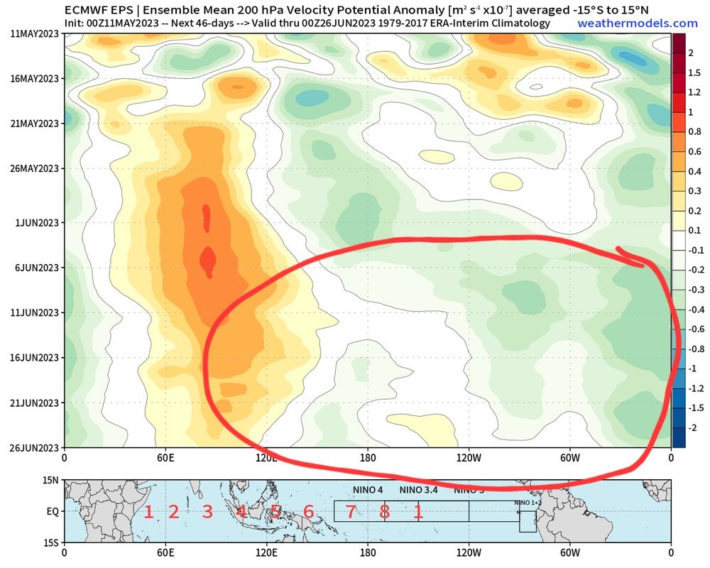
But EPS hovmollers show Increasing rising motion in the Atlantic and less so in the EPAC to begin June.
0 likes
RIP Kobe Bryant
-
cycloneye
- Admin
- Posts: 139199
- Age: 67
- Joined: Thu Oct 10, 2002 10:54 am
- Location: San Juan, Puerto Rico
Re: 2023 EPAC Season
And the 2023 season begins.


Tropical Weather Outlook
NWS National Hurricane Center Miami FL
500 AM PDT Mon May 15 2023
For the eastern North Pacific...east of 140 degrees west longitude:
Tropical cyclone formation is not expected during the next 7 days.
Today marks the first day of the eastern North Pacific hurricane
season, which will run until November 30. Long-term averages for
the number of named storms, hurricanes, and major hurricanes are
15, 8, and 4, respectively.
The list of names for 2023 is as follows:
Name Pronunciation Name Pronunciation
-------------------------------------------------------------
Adrian AY-dree-uhn Max maks
Beatriz BEE-a-triz Norma NOOR-muh
Calvin KAL-vin Otis OH-tis
Dora DOR-ruh Pilar Pee-LAHR
Eugene YOU-jeen Ramon rah-MOHN
Fernanda fer-NAN-dah Selma SELL-mah
Greg greg Todd tahd
Hilary HIH-luh-ree Veronica vur-RAHN-ih-kuh
Irwin UR-win Wiley WY-lee
Jova HO-vah Xina ZEE-nah
Kenneth KEH-neth York york
Lidia LIH-dyah Zelda ZEL-dah
This product, the Tropical Weather Outlook, briefly describes
significant areas of disturbed weather and their potential for
tropical cyclone formation during the next seven days. The issuance
times of this product are 5 AM, 11 AM, 5 PM, and 11 PM PDT. After
the change to standard time in November, the issuance times are
4 AM, 10 AM, 4 PM, and 10 PM PST.
A Special Tropical Weather Outlook will be issued to provide
updates, as necessary, in between the regularly scheduled issuances
of the Tropical Weather Outlook. Special Tropical Weather Outlooks
will be issued under the same WMO and AWIPS headers as the regular
Tropical Weather Outlooks.
A standard package of products, consisting of the tropical cyclone
public advisory, the forecast/advisory, the cyclone discussion, and
a wind speed probability product, is issued every six hours for all
ongoing tropical cyclones. In addition, a special advisory package
may be issued at any time to advise of significant unexpected
changes or to modify watches or warnings.
NHC has the option to issue advisories, watches, and warnings for
disturbances that are not yet a tropical cyclone, but which pose
the threat of bringing tropical storm or hurricane conditions to
land areas within 48 hours. For these land-threatening "potential
tropical cyclones", NHC will issue the full suite of advisory and
watch/warning products. Potential tropical cyclones share the
naming conventions currently in place for tropical depressions,
being numbered from a single list (e.g., "One-E", "Two-E",
"Three-E", etc.).
The Tropical Cyclone Update is a brief statement to inform of
significant changes in a tropical cyclone, to post or cancel
watches or warnings, or to provide hourly position updates between
intermediate advisories when the storm center is easily followed by
radar. The Tropical Cyclone Update is also used in lieu of or to
precede the issuance of a special advisory package. Tropical
Cyclone Updates, which can be issued at any time, can be found
under WMO header WTPZ61-65 KNHC, and under AWIPS header MIATCUEP1-5.
All NHC text and graphical products are available on the web at
https://www.hurricanes.gov. More information on NHC text products
can be found at https://www.hurricanes.gov/aboutnhcprod.shtml,
while more information about NHC graphical products can be
found at https://www.hurricanes.gov/aboutnhcgraphics.shtml.
You can also interact with NHC on Facebook at
https://www.facebook.com/NWSNHC. Notifications are available
via Twitter when select NHC products are issued. Information
about our east Pacific Twitter feed is available at
https://www.hurricanes.gov/twitter.php.
$$
Forecaster Kelly/Cangialosi
NNNN
1 likes
Visit the Caribbean-Central America Weather Thread where you can find at first post web cams,radars
and observations from Caribbean basin members Click Here
and observations from Caribbean basin members Click Here
-
DorkyMcDorkface
- Category 2
- Posts: 714
- Age: 26
- Joined: Mon Sep 30, 2019 1:32 pm
- Location: Mid-Atlantic
Re: 2023 EPAC Season
Looks like we won't be getting off to an early start like we did in 2020 and 2021 with 01E and Andres respectively. If those RMM plots are to be believed then the MJO does not look conducive for TC development for the next week or two, but yeah I suppose it is worth watching for a passing CCKW to provide a small favorable window for something to spin up, even if it ends up being weak and/or short lived.
2 likes
Floyd 1999 | Isabel 2003 | Hanna 2008 | Irene 2011 | Sandy 2012 | Isaias 2020
-
cycloneye
- Admin
- Posts: 139199
- Age: 67
- Joined: Thu Oct 10, 2002 10:54 am
- Location: San Juan, Puerto Rico
Re: 2023 EPAC Season
DorkyMcDorkface wrote:Looks like we won't be getting off to an early start like we did in 2020 and 2021 with 01E and Andres respectively. If those RMM plots are to be believed then the MJO does not look conducive for TC development for the next week or two, but yeah I suppose it is worth watching for a passing CCKW to provide a small favorable window for something to spin up, even if it ends up being weak and/or short lived.
You see a backloaded season?
0 likes
Visit the Caribbean-Central America Weather Thread where you can find at first post web cams,radars
and observations from Caribbean basin members Click Here
and observations from Caribbean basin members Click Here
-
DorkyMcDorkface
- Category 2
- Posts: 714
- Age: 26
- Joined: Mon Sep 30, 2019 1:32 pm
- Location: Mid-Atlantic
Re: 2023 EPAC Season
cycloneye wrote:DorkyMcDorkface wrote:Looks like we won't be getting off to an early start like we did in 2020 and 2021 with 01E and Andres respectively. If those RMM plots are to be believed then the MJO does not look conducive for TC development for the next week or two, but yeah I suppose it is worth watching for a passing CCKW to provide a small favorable window for something to spin up, even if it ends up being weak and/or short lived.
You see a backloaded season?
In terms of activity I do expect it to be busy from late September into November like I said before, as the Niño will have solidified itself by then. Before that I'm thinking we'll still see a good amount of activity, although the -PDO could throw a monkey wrench into things perhaps, if it persists anyway.
2 likes
Floyd 1999 | Isabel 2003 | Hanna 2008 | Irene 2011 | Sandy 2012 | Isaias 2020
-
cycloneye
- Admin
- Posts: 139199
- Age: 67
- Joined: Thu Oct 10, 2002 10:54 am
- Location: San Juan, Puerto Rico
Re: 2023 EPAC Season
DorkyMcDorkface wrote:cycloneye wrote:DorkyMcDorkface wrote:Looks like we won't be getting off to an early start like we did in 2020 and 2021 with 01E and Andres respectively. If those RMM plots are to be believed then the MJO does not look conducive for TC development for the next week or two, but yeah I suppose it is worth watching for a passing CCKW to provide a small favorable window for something to spin up, even if it ends up being weak and/or short lived.
You see a backloaded season?
In terms of activity I do expect it to be busy from late September into November like I said before, as the Niño will have solidified itself by then. Before that I'm thinking we'll still see a good amount of activity, although the -PDO could throw a monkey wrench into things perhaps, if it persists anyway.
What about how the Pacific Mexican coast / CentralAmerican Pacific coast fare? Will there be many or a handfull landfalling storms?
0 likes
Visit the Caribbean-Central America Weather Thread where you can find at first post web cams,radars
and observations from Caribbean basin members Click Here
and observations from Caribbean basin members Click Here
Who is online
Users browsing this forum: skyline385 and 120 guests