Tropical Wave in the Central Atlantic (10/60)

This is the general tropical discussion area. Anyone can take their shot at predicting a storms path.

Moderator: S2k Moderators

Forum rules

The posts in this forum are NOT official forecasts and should not be used as such. They are just the opinion of the poster and may or may not be backed by sound meteorological data. They are NOT endorsed by any professional institution or STORM2K. For official information, please refer to products from the National Hurricane Center and National Weather Service.

Help Support Storm2K
Message
Author
User avatar
cycloneye
Admin
Admin
Posts: 146154
Age: 69
Joined: Thu Oct 10, 2002 10:54 am
Location: San Juan, Puerto Rico

Tropical Wave in the Central Atlantic (10/60)

#1 Postby cycloneye » Sat Aug 16, 2025 6:24 pm

Central Tropical Atlantic:
An area of low pressure could form over the central tropical
Atlantic during the middle to latter portion of next week from a
westward moving tropical wave. Some subsequent development could
occur as the system moves westward to west-northwestward at around
15 mph.
* Formation chance through 48 hours...low...near 0 percent.
* Formation chance through 7 days...low...20 percent.


Image
5 likes   
Visit the Caribbean-Central America Weather Thread where you can find at first post web cams,radars
and observations from Caribbean basin members Click Here

TampaWxLurker
Tropical Storm
Tropical Storm
Posts: 151
Joined: Thu Aug 01, 2024 8:20 am

Re: Possible development in the MDR from a Tropical Wave (0/20)

#2 Postby TampaWxLurker » Sat Aug 16, 2025 6:41 pm

Just repeating the mantra to myself:

The safest place to be is the place where the GFS says a major hurricane is going to be 10+ days out. More often than not, it's just a phantom and/or won't go where it thinks it will that far out.
Last edited by TampaWxLurker on Sat Aug 16, 2025 6:43 pm, edited 1 time in total.
1 likes   

User avatar
Teban54
Category 5
Category 5
Posts: 3252
Joined: Sat May 19, 2018 1:19 pm

Re: Possible development in the MDR from a Tropical Wave (0/20)

#3 Postby Teban54 » Sat Aug 16, 2025 6:46 pm

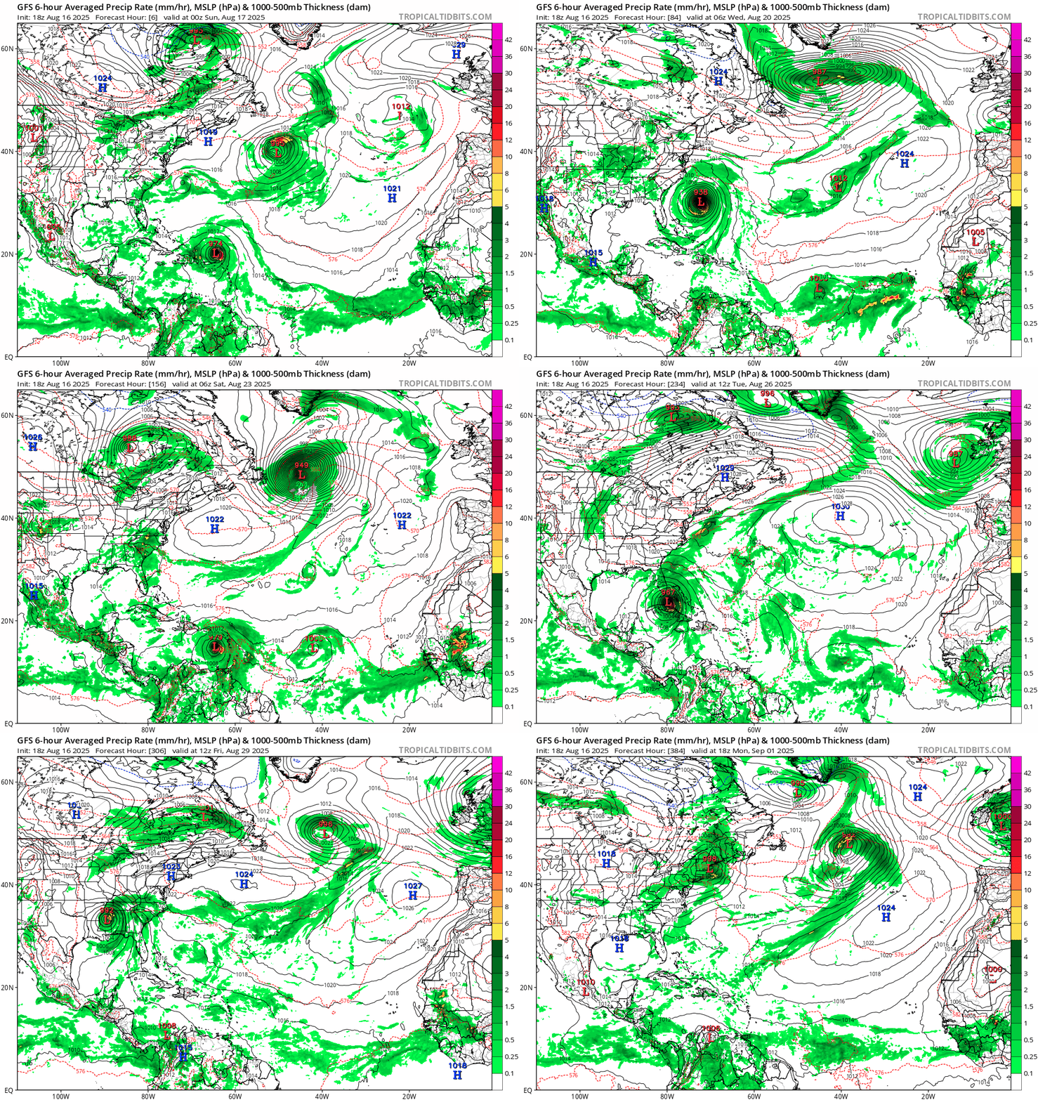
18z GFS. David 1979 is the analog that immediately came to my mind: going through Hispaniola (aka the shredder), yet still recovering before an FL hit (much stronger than David and on the other side of the peninsula).

Image
1 likes   

LAF92
Tropical Depression
Tropical Depression
Posts: 80
Joined: Fri Aug 18, 2023 6:27 pm

Re: Possible development in the MDR from a Tropical Wave (0/20)

#4 Postby LAF92 » Sat Aug 16, 2025 6:52 pm

FWIW the 18z Euro has a stronger wave than it has had the last couple days. Still weak but seems like it’s starting to catch on.
1 likes   

User avatar
Hurrilurker
Category 2
Category 2
Posts: 728
Joined: Mon Jun 09, 2003 3:32 pm
Location: San Francisco, CA

Re: Possible development in the MDR from a Tropical Wave (0/20)

#5 Postby Hurrilurker » Sat Aug 16, 2025 6:54 pm

A lot of people got lucky with Erin's track, but this one looks like a real serious threat with large potential impact range.
4 likes   

LarryWx
S2K Supporter
S2K Supporter
Posts: 6465
Joined: Sun Sep 07, 2003 2:04 pm
Location: GA

Re: Possible development in the MDR from a Tropical Wave (0/20)

#6 Postby LarryWx » Sat Aug 16, 2025 6:58 pm

12Z UK has TS 3rd run in row but this unlike prior 2 runs recurves ~62W due to Erin to its N:

NEW TROPICAL CYCLONE FORECAST TO DEVELOP AFTER 102 HOURS
FORECAST POSITION AT T+102 : 15.6N 48.6W

LEAD CENTRAL MAXIMUM WIND
VERIFYING TIME TIME POSITION PRESSURE (MB) SPEED (KNOTS)
-------------- ---- -------- ------------- -------------
0000UTC 21.08.2025 108 16.8N 50.3W 1009 26
1200UTC 21.08.2025 120 18.5N 54.0W 1008 31
0000UTC 22.08.2025 132 20.3N 56.7W 1006 31
1200UTC 22.08.2025 144 21.9N 59.3W 1005 36
0000UTC 23.08.2025 156 24.5N 61.2W 1006 35
1200UTC 23.08.2025 168 25.3N 61.8W 1006 38
1 likes   
Personal Forecast Disclaimer:
The posts in this forum are NOT official forecasts and should not be used as such. They are just the opinion of the poster and may or may not be backed by sound meteorological data. They are NOT endorsed by any professional institution or storm2k.org. For official information, please refer to the NHC and NWS products.

TampaWxLurker
Tropical Storm
Tropical Storm
Posts: 151
Joined: Thu Aug 01, 2024 8:20 am

Re: Possible development in the MDR from a Tropical Wave (0/20)

#7 Postby TampaWxLurker » Sat Aug 16, 2025 7:23 pm

The main difference to my very untrained eye between all the various models that take it back out to sea (Euro & UK) or trap it under the ridge (GFS), seems to be the timing of Erin's exit and the ridge building back behind it and if the wave is quick to move west following it or takes its time developing.

Here's to hoping it gets itself moving west quickly enough to take the escape hatch while Erin is still holding it open.
3 likes   

LAF92
Tropical Depression
Tropical Depression
Posts: 80
Joined: Fri Aug 18, 2023 6:27 pm

Re: Possible development in the MDR from a Tropical Wave (0/20)

#8 Postby LAF92 » Sat Aug 16, 2025 7:30 pm

TampaWxLurker wrote:The main difference to my very untrained eye between all the various models that take it back out to sea (Euro & UK) or trap it under the ridge (GFS), seems to be the timing of Erin's exit and the ridge building back behind it and if the wave is quick to move west following it or takes its time developing.

Here's to hoping it gets itself moving west quickly enough to take the escape hatch while Erin is still holding it open.


 https://x.com/hurricaneaddict/status/1956863132711928190

0 likes   

DunedinDave
Category 1
Category 1
Posts: 250
Joined: Fri Aug 25, 2023 10:31 am

Re: Possible development in the MDR from a Tropical Wave (0/20)

#9 Postby DunedinDave » Sat Aug 16, 2025 8:02 pm

My gut still says this thing will recurve like the rest. What the euro has done with the wave it’s kicked it right. So we will see. Got to see if it develops firstZ
0 likes   

LarryWx
S2K Supporter
S2K Supporter
Posts: 6465
Joined: Sun Sep 07, 2003 2:04 pm
Location: GA

Re: Possible development in MDR from Tropical Wave (0/20)

#10 Postby LarryWx » Sat Aug 16, 2025 9:10 pm

TampaWxLurker wrote:The main difference to my very untrained eye between all the various models that take it back out to sea (Euro & UK) or trap it under the ridge (GFS), seems to be the timing of Erin's exit and the ridge building back behind it and if the wave is quick to move west following it or takes its time developing.

Here's to hoping it gets itself moving west quickly enough to take the escape hatch while Erin is still holding it open.


I just looked at the last 4 UKMET runs and discovered that the reason the latest run recurves this AOI into Erin is because Erin is further SW due to a further W recurve and thus doesn’t exit until a couple of days later than yesterday’s runs:

UKMET progs for 0Z 8/22:

1) 0Z 8/15 run at 168 hrs:
Erin 954 mb at 38N, 59W after recurve at 70W
AOI 1011 mb at 20N, 61W, is 1,250 miles to the S

2) 12Z 8/15 run at 156 hrs:
Erin 949 mb at 42N, 57W after recurve at 70W
AOI 1006 mb at 18N, 62W, is 1,700 miles to the SSW

3) 0Z 8/16 run at 144 hrs:
Erin 962 mb at 37N, 66W after recurve at 73W
AOI 1007 mb at 16N, 59W, is 1,500 miles to the SSE

4) 12Z 8/16 run at 132 hrs:
Erin 958 mb at 35N, 71W after recurve at 74W
AOI 1006 mb at 20N, 57W, is 1,350 miles to the SE moving NW to the S of retreating H5 ridge

Conclusion:
It isn’t just about how fast the AOI moves W and develops, but also and possibly more crucially it is about how far W Erin recurves. The further W Erin recurves, the longer it will take for her to exit. The later the exit, the better chance the AOI would have to recurve before reaching the Conus.
2 likes   
Personal Forecast Disclaimer:
The posts in this forum are NOT official forecasts and should not be used as such. They are just the opinion of the poster and may or may not be backed by sound meteorological data. They are NOT endorsed by any professional institution or storm2k.org. For official information, please refer to the NHC and NWS products.

Stratton23
Category 5
Category 5
Posts: 2631
Joined: Fri Jul 21, 2023 10:59 pm
Location: Katy, Tx

Re: Possible development in the MDR from a Tropical Wave (0/20)

#11 Postby Stratton23 » Sat Aug 16, 2025 9:31 pm

We will see what happens, but as of now, this definitely looks like a much greater chance of being a threat to the US, Especially if it tracks through the caribbean like what the GFS suggests
4 likes   

User avatar
StPeteMike
Category 2
Category 2
Posts: 650
Joined: Thu Jun 07, 2018 11:26 pm

Re: Possible development in the MDR from a Tropical Wave (0/20)

#12 Postby StPeteMike » Sat Aug 16, 2025 10:23 pm

I will say, both the GFS and Euro seem to have initialized Erin too far east, as it’s already where it should be at 6z tomorrow looking at satellite images. Satellite for Erin shows it has begun a more north leaning component of its WNW movement.

Not sure what, if any, impacts this will have on this AOI but will be interesting to see if more models jump onboard with development the next couple days.
0 likes   
The above post is not official and should not be used as such. It is the opinion of the poster and may or may not be backed by sound meteorological data. It is not endorsed by any professional institution or storm2k.org. For official information, please refer to the NHC and NWS products.

LAF92
Tropical Depression
Tropical Depression
Posts: 80
Joined: Fri Aug 18, 2023 6:27 pm

Re: Possible development in the MDR from a Tropical Wave (0/20)

#13 Postby LAF92 » Sat Aug 16, 2025 10:27 pm

Stratton23 wrote:We will see what happens, but as of now, this definitely looks like a much greater chance of being a threat to the US, Especially if it tracks through the caribbean like what the GFS suggests

00z ICON getting on board with a stronger wave than its previously had
0 likes   

AutoPenalti
Category 5
Category 5
Posts: 4059
Age: 29
Joined: Mon Aug 17, 2015 4:16 pm
Location: Ft. Lauderdale, Florida

Re: Possible development in the MDR from a Tropical Wave (0/20)

#14 Postby AutoPenalti » Sat Aug 16, 2025 10:32 pm

I’d like to wager a OTS solution if Erin doesn’t move as quick to the NE.

Odds though are a LOT lower than Erin at this time of development.
1 likes   
The posts in this forum are NOT official forecasts and should not be used as such. They are just the opinion of the poster and may or may not be backed by sound meteorological data. They are NOT endorsed by any professional institution or STORM2K. For official information, please refer to products from the NHC and NWS.


Model Runs Cheat Sheet:
GFS (5:30 AM/PM, 11:30 AM/PM)
HWRF, GFDL, UKMET, NAVGEM (6:30-8:00 AM/PM, 12:30-2:00 AM/PM)
ECMWF (1:45 AM/PM)

TCVN
is a weighted averaged

Stratton23
Category 5
Category 5
Posts: 2631
Joined: Fri Jul 21, 2023 10:59 pm
Location: Katy, Tx

Re: Possible development in the MDR from a Tropical Wave (0/20)

#15 Postby Stratton23 » Sat Aug 16, 2025 10:39 pm

00z ICON with a TS at hour 150 headed due west in the northern caribbean, just barely south of the islands , looks like ridging holds firm on this run
2 likes   

TomballEd
Category 3
Category 3
Posts: 822
Age: 61
Joined: Wed Aug 16, 2023 4:52 pm
Location: Spring/Klein area, not Tomball

Re: Possible development in the MDR from a Tropical Wave (0/20)

#16 Postby TomballEd » Sat Aug 16, 2025 10:50 pm

DunedinDave wrote:My gut still says this thing will recurve like the rest. What the euro has done with the wave it’s kicked it right. So we will see. Got to see if it develops firstZ


My gut as well. I think the weakness remains.

But my gut has been wrong before.
Oh, ICON runs it through Hispaniola and into Eastern Cuba. It would be heading WNW and looks like it will survive all the mountains.
0 likes   

zzzh
Category 3
Category 3
Posts: 878
Joined: Thu Sep 02, 2021 1:13 pm

Re: Possible development in the MDR from a Tropical Wave (0/20)

#17 Postby zzzh » Sat Aug 16, 2025 10:52 pm

Image
Image
The wave already looks like a TD with a well defined circulation and persistent convection.
5 likes   

Sambucol2024
Tropical Depression
Tropical Depression
Posts: 62
Joined: Mon Feb 26, 2024 1:54 pm

Re: Possible development in the MDR from a Tropical Wave (0/20)

#18 Postby Sambucol2024 » Sat Aug 16, 2025 11:10 pm

Stratton23 wrote:00z ICON with a TS at hour 150 headed due west in the northern caribbean, just barely south of the islands , looks like ridging holds firm on this run


If it were to stay on that track, where would that put it in the Gulf? Or not?
0 likes   

Pelicane
Tropical Storm
Tropical Storm
Posts: 120
Joined: Tue Sep 13, 2022 1:52 pm
Location: Lafayette, Louisiana

Re: Possible development in the MDR from a Tropical Wave (0/20)

#19 Postby Pelicane » Sat Aug 16, 2025 11:14 pm

Seems like the ULL that the wave will encounter in about 4-5 days time has been trending stronger and more NE on the last 5 GFS runs. Could impart shear and limit its intensity as it reaches the Lesser Antilles.

And if I had to guess it's probably due to Erin trending slower and more west on the model, since Erin's outflow seems to strengthen it the closer it gets.

https://imgur.com/a/PmwQCLL
1 likes   

LAF92
Tropical Depression
Tropical Depression
Posts: 80
Joined: Fri Aug 18, 2023 6:27 pm

Re: Possible development in the MDR from a Tropical Wave (0/20)

#20 Postby LAF92 » Sat Aug 16, 2025 11:22 pm

Pelicane wrote:Seems like the ULL that the wave will encounter in about 4-5 days time has been trending stronger and more NE on the last 5 GFS runs. Could impart shear and limit its intensity as it reaches the Lesser Antilles.

And if I had to guess it's probably due to Erin trending slower and more west on the model, since Erin's outflow seems to strengthen it the closer it gets.

https://imgur.com/a/PmwQCLL

The 00z GFS is the weakest run so far through 170 hours over the past few runs
0 likes   


Return to “Talkin' Tropics”

Who is online

Users browsing this forum: Ulf and 48 guests