Memorable re-intensifying storms...

This is the general tropical discussion area. Anyone can take their shot at predicting a storms path.

Moderator: S2k Moderators

Forum rules

The posts in this forum are NOT official forecasts and should not be used as such. They are just the opinion of the poster and may or may not be backed by sound meteorological data. They are NOT endorsed by any professional institution or STORM2K. For official information, please refer to products from the National Hurricane Center and National Weather Service.

Help Support Storm2K
Message
Author
Anonymous

Memorable re-intensifying storms...

#1 Postby Anonymous » Sun Jul 04, 2004 4:30 pm

It is hard to say. I always thought once TS Isidore would have crossed back into the Gulf, it would explode back into a major hurricane. The core was WAY too damaged though. It did jump from 40 mph to 60 mph rather quickly though.

Hurricane Keith was a good one. Even though it was down to a depresson, it wasted no time. Look at the outflow:

Image

It hit north of Tampico, MX as a strong category 1 of 90 mph. Had it had another 12 hrs, it might have been a major hurricane.

ANY OTHER memorable re-intensifying storms???
0 likes   

Brent
S2K Supporter
S2K Supporter
Posts: 38258
Age: 37
Joined: Sun May 16, 2004 10:30 pm
Location: Tulsa Oklahoma
Contact:

#2 Postby Brent » Sun Jul 04, 2004 4:46 pm

I felt certain Isidore would too(I never expected it to hit the Yucatan though). BUT, I could tell when the inner core collapsed it wouldn't intensify back to a Cat 3. I still thought a Cat 1 or Cat 2 though.
0 likes   
#neversummer

Anonymous

#3 Postby Anonymous » Sun Jul 04, 2004 6:25 pm

I know. Infact, had Lili stayed over water for 12 more hours, 145 mph again???
0 likes   

User avatar
Hurricanehink
S2K Supporter
S2K Supporter
Posts: 2044
Joined: Sun Nov 16, 2003 2:05 pm
Location: New Jersey

#4 Postby Hurricanehink » Sun Jul 04, 2004 6:40 pm

Two I can think of are the 2 last ones of the 1998 hurricane season: Mitch and Nicole. Mitch, after devestating Central America, weakened and died.... or so we thought. When it reintensifyed, that was very memorable for me, at least. I thought the storm was done and over, like many others, but it became a tropical storm again. Nicole was another. We all thought the season was over when Nicole "dissipated" from westerly shear. Nicole, like a pheonix, rose from her ashes and became stronger than before, reaching hurricane strength and ending the 1998 hurricane season with one last punch.
0 likes   

Anonymous

#5 Postby Anonymous » Sun Jul 04, 2004 8:06 pm

What about Roxanne in 1995. That actually went from 85 mph in the Bay of Campeche to NOTHING. I wish there were better images to see the destruction of ROXY.
0 likes   

User avatar
HURAKAN
Professional-Met
Professional-Met
Posts: 46086
Age: 38
Joined: Thu May 20, 2004 4:34 pm
Location: Key West, FL
Contact:

#6 Postby HURAKAN » Sun Jul 04, 2004 10:58 pm

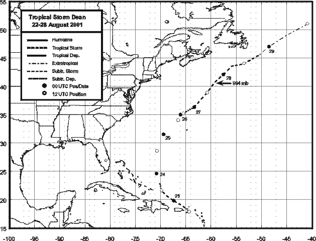
In 2001 Dean formed north of Puerto Rico around the 22nd of August with 60 mph winds and the day after dissipated thanks to a strong trough off the American coast. The storm then looked to have dissipated and then on the 27th came back again as a strong tropical storm almost reaching hurricane intensity NE the Bermuda Islands. Interesting to note is although Dean developed quickly also its demise was quick.

Image
0 likes   

HurricaneBill
Category 5
Category 5
Posts: 3420
Joined: Sun Apr 11, 2004 5:51 pm
Location: East Longmeadow, MA, USA

#7 Postby HurricaneBill » Sun Jul 04, 2004 11:02 pm

In 1964, Hurricane Cleo rapidly intensified in the 8 hours prior to her Florida landfall. In those 8 hours, Cleo's sustained winds increased from 80 mph to 110 mph.

Dennis stalled off NC and winds dropped from 105 mph to 50 mph. After stalling for a few days, Dennis finally moved towards NC and began to strengthen again. Dennis never regained hurricane status, but moved onshore with sustained winds of 70 mph.

In 1996, Hurricane Bertha had become extremely disorganized and dropped from Category 3 to Category 1. Prior to landfall, Bertha became much better organized and strengthened up to Category 2.

After being seeded in 1969, Hurricane Debbie's sustained winds plunged from 110 mph to 80 mph. However, after a day with no seeding, Debbie quickly reintensified from 80 mph to 120 mph.
0 likes   

User avatar
Stormsfury
Category 5
Category 5
Posts: 10549
Age: 53
Joined: Wed Feb 05, 2003 6:27 pm
Location: Summerville, SC

#8 Postby Stormsfury » Sun Jul 04, 2004 11:28 pm

~Floydbuster wrote:I know. Infact, had Lili stayed over water for 12 more hours, 145 mph again???


No ... it would have continued to decrease even further with the collapse of the inner core (eyewall replacement cycle which never would have regenerated anyway) and an ULL which formed in Eastern TX producing tremendous amounts of shear over Lili.

SF
0 likes   

User avatar
Stormsfury
Category 5
Category 5
Posts: 10549
Age: 53
Joined: Wed Feb 05, 2003 6:27 pm
Location: Summerville, SC

#9 Postby Stormsfury » Sun Jul 04, 2004 11:29 pm

~Floydbuster wrote:What about Roxanne in 1995. That actually went from 85 mph in the Bay of Campeche to NOTHING. I wish there were better images to see the destruction of ROXY.


Roxanne sat in the BOC for so many days, it caused its own death due to upwelling ...
0 likes   

User avatar
Stormsfury
Category 5
Category 5
Posts: 10549
Age: 53
Joined: Wed Feb 05, 2003 6:27 pm
Location: Summerville, SC

#10 Postby Stormsfury » Sun Jul 04, 2004 11:35 pm

Dennis stalled off NC and winds dropped from 105 mph to 50 mph. After stalling for a few days, Dennis finally moved towards NC and began to strengthen again. Dennis never regained hurricane status, but moved onshore with sustained winds of 70 mph.


Yep ... Dennis actually at one point, lost its core and was subjected to fairly strong shear. At one point, it almost looked like it had lost tropical characteristics or was subtropical for a time. It stalled as well, and was subject to upwelling as well, although, not as pronounced as Roxanne in the BOC due to the Gulf Stream current.

In 1996, Hurricane Bertha had become extremely disorganized and dropped from Category 3 to Category 1. Prior to landfall, Bertha became much better organized and strengthened up to Category 2.


s/w trough approached it from the west across the Carolinas before stalling out and lifting ... this produced enough shear to interfere with the western portion of Bertha. After it lifted out, Bertha reorganized.

After being seeded in 1969, Hurricane Debbie's sustained winds plunged from 110 mph to 80 mph. However, after a day with no seeding, Debbie quickly reintensified from 80 mph to 120 mph.


Which is exactly why cloud seeding hurricanes was questionable in the first place ... it only caused short term changes, and once it reorganized itself (in a matter of hours), it was just as strong before ...

In 1947, another hurricane (that was weakening) was seeded that was recurving out to sea. However, after the hurricane was seeded, suddenly the storm turned abruptly west and made landfall in Georgia, and produced a tremendous amount of flooding in GA/SC ... the pattern itself was to blame for the abrupt turn to the west, and for a good many years, cloud seeding hurricanes was scrapped.
0 likes   

User avatar
PTPatrick
Category 5
Category 5
Posts: 1831
Joined: Sat Jun 12, 2004 8:38 am

Georges

#11 Postby PTPatrick » Sun Jul 04, 2004 11:58 pm

He came throught the islands losing much of his punch...but I think most folks on the mississippi coast(particularly jackson county) would agree that it was a formidible storm at landfall. It was borderline cat 2-3...but the water was AMAZING...something 25 inches of rain...and storm surge of a cat strong cat 3 or 4...we had 14 ft on the bayou I live on.
0 likes   

Anonymous

#12 Postby Anonymous » Mon Jul 05, 2004 12:55 am

Stormsfury wrote:
~Floydbuster wrote:I know. Infact, had Lili stayed over water for 12 more hours, 145 mph again???


No ... it would have continued to decrease even further with the collapse of the inner core (eyewall replacement cycle which never would have regenerated anyway) and an ULL which formed in Eastern TX producing tremendous amounts of shear over Lili.

SF


NOT TRUE. it has been proven thta the symettry was getting better right at and after landfall and that is was on it's way to major hurricane again right as it hit.
0 likes   

LarryWx
S2K Supporter
S2K Supporter
Posts: 6853
Joined: Sun Sep 07, 2003 2:04 pm
Location: GA

#13 Postby LarryWx » Mon Jul 05, 2004 9:01 am

[quote="Stormsfury
In 1947, another hurricane (that was weakening) was seeded that was recurving out to sea. However, after the hurricane was seeded, suddenly the storm turned abruptly west and made landfall in Georgia, and produced a tremendous amount of flooding in GA/SC ... the pattern itself was to blame for the abrupt turn to the west, and for a good many years, cloud seeding hurricanes was scrapped.[/quote]

SF,
Although an upper high to the north ultimately allowed it to turn left back to the coast, imo nobody could possibly know for sure the exact influence the seeding may have indirectly had on the ultimate track. This is because theoretically the seeding itself could have caused a lowering of cloud tops and therefore a lowering of the mean steering level. Assuming the mean steering level was lowered, the mean steering flow should have changed at least slightly in direction/strength from what it would have been. So, whereas it very well may have still turned left to the coast w/o the seeding, some subtle change in the course still could have occurred. Instead of hitting Savannah directly, it could have instead hit, say, Beaufort or Charleston. Or perhaps had the seeding not been done, who can prove that it couldn't have continued NEward with the upper trough after just barely missing being blocked by the upper high moving in? Sometimes the timing of these things is very tight.

This issue, imo, will always make hurricane modifications VERY controversial.

Has anyone heard anything from Dyn-O-Mat lately?
0 likes   
Personal Forecast Disclaimer:
The posts in this forum are NOT official forecasts and should not be used as such. They are just the opinion of the poster and may or may not be backed by sound meteorological data. They are NOT endorsed by any professional institution or storm2k.org. For official information, please refer to the NHC and NWS products.

Anonymous

#14 Postby Anonymous » Tue Jul 06, 2004 8:14 pm

They are so fake.
0 likes   


Return to “Talkin' Tropics”

Who is online

Users browsing this forum: KirbyDude25 and 104 guests