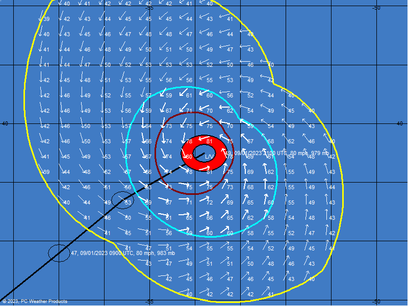
Good Wind image

This is the general tropical discussion area. Anyone can take their shot at predicting a storms path.

Moderator: S2k Moderators

Forum rules

The posts in this forum are NOT official forecasts and should not be used as such. They are just the opinion of the poster and may or may not be backed by sound meteorological data. They are NOT endorsed by any professional institution or STORM2K. For official information, please refer to products from the National Hurricane Center and National Weather Service.

Help Support Storm2K
Message
Author
chadtm80

Good Wind image

#1 Postby chadtm80 » Thu Sep 02, 2004 9:58 am

Image
0 likes   

rtd2
Category 5
Category 5
Posts: 1183
Joined: Tue Aug 12, 2003 12:45 pm
Location: Biloxi, MS

#2 Postby rtd2 » Thu Sep 02, 2004 10:00 am

great info...much larger windfield than charley
0 likes   

User avatar
Lindaloo
Category 5
Category 5
Posts: 22658
Joined: Sat Mar 29, 2003 10:06 am
Location: Pascagoula, MS

#3 Postby Lindaloo » Thu Sep 02, 2004 10:01 am

WOW! Look how far tropical force winds extend and hurricane force. Well done Chad.
0 likes   

rtd2
Category 5
Category 5
Posts: 1183
Joined: Tue Aug 12, 2003 12:45 pm
Location: Biloxi, MS

#4 Postby rtd2 » Thu Sep 02, 2004 10:26 am

great info...much larger windfield than charley
0 likes   

Rainband

#5 Postby Rainband » Thu Sep 02, 2004 10:27 am

Scary, I hope your leaving Chad :eek:
0 likes   


Return to “Talkin' Tropics”

Who is online

Users browsing this forum: Team Ghost and 275 guests