I keep hearing a "hurricane never survives going through hispaniola" - but where is it..? Is it a group of islands or part of the sea in the Caribbean?
Had a look at various maps and can't seem to find reference to it.
Apologise to this rather basic and perhaps obvious question!
hispaniola - where is it?
Moderator: S2k Moderators
Forum rules

The posts in this forum are NOT official forecasts and should not be used as such. They are just the opinion of the poster and may or may not be backed by sound meteorological data. They are NOT endorsed by any professional institution or STORM2K. For official information, please refer to products from the National Hurricane Center and National Weather Service.
-
Florida_brit
- Tropical Storm

- Posts: 159
- Joined: Sun Aug 29, 2004 11:54 am
- Location: Jensen Beach, FL
hispaniola - where is it?
0 likes
-
dennis1x1
-
southerngale

- Retired Staff

- Posts: 27418
- Joined: Thu Oct 10, 2002 1:27 am
- Location: Southeast Texas (Beaumont area)


-
dennis1x1
-
southerngale
- Retired Staff
- Posts: 27418
- Joined: Thu Oct 10, 2002 1:27 am
- Location: Southeast Texas (Beaumont area)
I just found a detailed map for you. This could come in handy for other storms as well.
Here's the link to bookmark: http://www.worldatlas.com/webimage/coun ... ribnew.gif
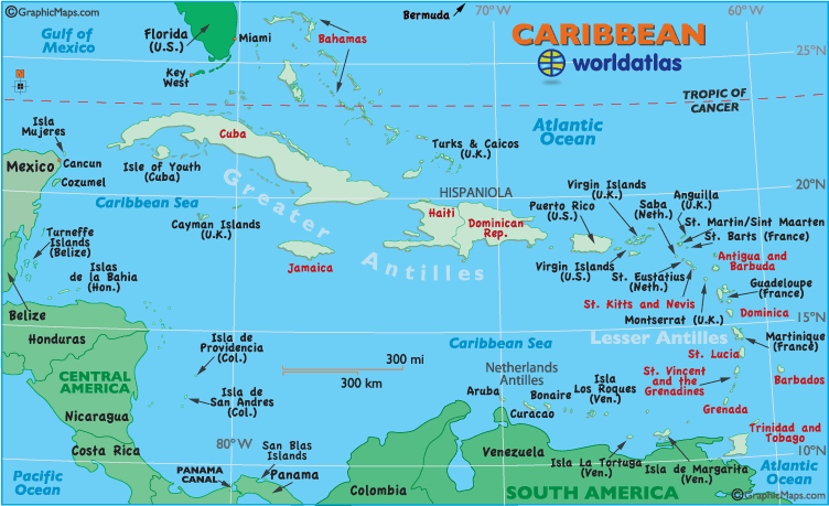
Here's the link to bookmark: http://www.worldatlas.com/webimage/coun ... ribnew.gif
0 likes
-
Florida_brit
- Tropical Storm
- Posts: 159
- Joined: Sun Aug 29, 2004 11:54 am
- Location: Jensen Beach, FL
Dennis1x1 guess you are talking in generalisations (never say never!)! " all i know is anything going over that blob of land gets ripped to shreds"
Yes I have heard that? My knowledge of the area is very poor. Is it because of the gulf stream/gulf of mexico currentls? Mountains? Just wondering why.
So I guess it is a area part of the Caribbean including Hati.
Thanks for your help!
Yes I have heard that? My knowledge of the area is very poor. Is it because of the gulf stream/gulf of mexico currentls? Mountains? Just wondering why.
So I guess it is a area part of the Caribbean including Hati.
Thanks for your help!
0 likes
-
dennis1x1

-
BlizzardNole
- Tropical Low

- Posts: 40
- Joined: Fri Dec 05, 2003 4:24 pm
- Location: Germantown, MD
Hispaniola is HUGE...(Compare it to Puerto Rico to its east which is 100 miles by 30 miles)...and it has numerous 10,000-plus foot mountains. It will chew any hurricane up and spit it out, and the cane will never recover.
BUT -- Haiti and DR are the poorest most destitute countries in the Caribbean, and are heavily populated. Many of the people live in shacks and have no protection at all. A direct hit with 150-mph winds could cause a death toll in the thousands.
BUT -- Haiti and DR are the poorest most destitute countries in the Caribbean, and are heavily populated. Many of the people live in shacks and have no protection at all. A direct hit with 150-mph winds could cause a death toll in the thousands.
0 likes

-
AussieMark

- Category 5

- Posts: 5858
- Joined: Tue Sep 02, 2003 6:36 pm
- Location: near Sydney, Australia
BlizzardNole wrote:Hispaniola is HUGE...(Compare it to Puerto Rico to its east which is 100 miles by 30 miles)...and it has numerous 10,000-plus foot mountains. It will chew any hurricane up and spit it out, and the cane will never recover.
BUT -- Haiti and DR are the poorest most destitute countries in the Caribbean, and are heavily populated. Many of the people live in shacks and have no protection at all. A direct hit with 150-mph winds could cause a death toll in the thousands.
in 1998 Georges hit around Santo Domingo.
380 were killed across Dominican Republic
209 were killed in Haiti.
thats 589 combined
Winds were 120 mph (Categoey 3)
Georges was over Hispaniola for 21 hours.
Imagine what Ivan would do with his projected 150 mph winds.
0 likes


-
frankthetank
- Category 2

- Posts: 527
- Joined: Mon Aug 09, 2004 6:16 pm
- Location: La Crosse, WI

-
southerngale
- Retired Staff
- Posts: 27418
- Joined: Thu Oct 10, 2002 1:27 am
- Location: Southeast Texas (Beaumont area)

hispaniola
it is not the poorest part of the caribean. la Hispaniola is divided into to main country : Haiti with 5.2 million people. Dominican Republic 8.5 million people wich main economic is tourism ...
we have the lasgest chain of beach resort in america,but we are very well known as baseball players (pedro martinez,alex rodriguez)... now we are the capital of tourism.
when hurricane david affected the island(1979), the govermnet forced almost everyone to build their house in cements,it is not true, that most of the island is not prepared. (house are checked every years by the office gov.of each provinces(32 in total).
i live in miami now, and i go every month to the islands right now we have 350,000 tourist(canadian,americans,and europeans) in the different beach resort, Domincan republic will remind you the center of miami,but most of the people work on the free-zone and tourism. we ship suggar,chocolate!! to the usa and canada.(banana and all kind of tropical fruits...ect) ..
if you need more info go to : http://www.puntacana.com
but is not the poorest island,no way amigos plus 45 % of the people are american citizens or resident
new york 2.5 million dominicans
border with haiti = to 350 km. protected by the usa marine force in the domincan side and french troops in the hatians side.
0 likes
-
southerngale
- Retired Staff
- Posts: 27418
- Joined: Thu Oct 10, 2002 1:27 am
- Location: Southeast Texas (Beaumont area)
Pico Duarte
The Dominican Republic is home to the highest peak in the caribbean.
Pico Duarte is just over 10,000 feet. Below freezing temps and snow
have been reported at the top during the winter months. It is a quick departure from balmy tropical weather. This peak plays a huge roll
when a tropical system tries to travers Hispanola and will most certainly tear up a system. However, a lot has to do with what angle the system will cross. If it is where current tracks show it, SW portion of island,
hinderance on system would not be as extreme
0 likes
Who is online
Users browsing this forum: Google Adsense [Bot] and 86 guests