
Frances forming an eye at the last minute
Moderator: S2k Moderators
Forum rules

The posts in this forum are NOT official forecasts and should not be used as such. They are just the opinion of the poster and may or may not be backed by sound meteorological data. They are NOT endorsed by any professional institution or STORM2K. For official information, please refer to products from the National Hurricane Center and National Weather Service.
-
PurdueWx80
- Professional-Met

- Posts: 2720
- Joined: Fri Aug 13, 2004 8:33 pm
- Location: Madison, WI
- Contact:
Frances forming an eye at the last minute
probably due to frictional effects of land and super-warm water in NE Gulf. Visible satellite also confirms deep-ish convection surrounding the eye-like feature.
0 likes


You are looking at a struggling declining system with most of its good side over land sputtering before finally moving on shore. That feature is at best a weak tropical storm axis lingering over warm water. It's weakening influence, the dry air on its SW side, is still obviously fully in place.
Frances really taught me a lesson on my assumed presumptions about cyclones. She really beat most of my pre-concepts on hurricane behavior. She didn't shift left under a firm ridge, but instead compromised in a slowing track right into it and wound down. Anti-climatic, and equally as grinding to those who think they knew storms...
Frances really taught me a lesson on my assumed presumptions about cyclones. She really beat most of my pre-concepts on hurricane behavior. She didn't shift left under a firm ridge, but instead compromised in a slowing track right into it and wound down. Anti-climatic, and equally as grinding to those who think they knew storms...
0 likes
-
Innotech

- Category 5

- Posts: 1031
- Joined: Mon Aug 30, 2004 5:32 pm
- Location: Lafayette, Louisiana
- Contact:
Sanibel wrote:You are looking at a struggling declining system with most of its good side over land sputtering before finally moving on shore. That feature is at best a weak tropical storm axis lingering over warm water. It's weakening influence, the dry air on its SW side, is still obviously fully in place.
Frances really taught me a lesson on my assumed presumptions about cyclones. She really beat most of my pre-concepts on hurricane behavior. She didn't shift left under a firm ridge, but instead compromised in a slowing track right into it and wound down. Anti-climatic, and equally as grinding to those who think they knew storms...
yeah it had a lot of people in confusion (including me) but it did hsow that a strong ridge will NOT allow full passage, which is why I kept saying no Carolinas hit.
0 likes
-
wxman57

- Moderator-Pro Met

- Posts: 23154
- Age: 68
- Joined: Sat Jun 21, 2003 8:06 pm
- Location: Houston, TX (southwest)
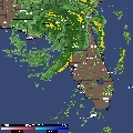
Sanibel wrote:You are looking at a struggling declining system with most of its good side over land sputtering before finally moving on shore. That feature is at best a weak tropical storm axis lingering over warm water. It's weakening influence, the dry air on its SW side, is still obviously fully in place.
Yep, I agree. Here's a 15Z plot with a radar overlay to prove it. Still no obs of over 35kts offshore. Minimal TS at best, so it has no eye. Just a ring of showers around the center:
<img src="http://myweb.cableone.net/nolasue/francessfc2.gif">
0 likes
-
Storminole
- Tropical Depression

- Posts: 70
- Age: 64
- Joined: Wed Aug 11, 2004 5:53 pm
- Location: Tallahassee, FL
It looks like Frances is about to make her final landfall near the St. Marks lighthouse in the NE corner of the GOM. Built in 1832 and now located in a wildlife refuge, it's weathered many a storm. This is well east of Apalachicola, and Frances' center apparently has been heading more NNW than NW over the past several hours.

0 likes
Who is online
Users browsing this forum: Google Adsense [Bot] and 85 guests