FRANCES TRACK
Moderator: S2k Moderators
Forum rules

The posts in this forum are NOT official forecasts and should not be used as such. They are just the opinion of the poster and may or may not be backed by sound meteorological data. They are NOT endorsed by any professional institution or STORM2K. For official information, please refer to products from the National Hurricane Center and National Weather Service.
FRANCES TRACK
Perhaps it is of no matter at this point but FRANCES is clearly tracking in well east of the NHC predicted path. I am mindful that the NHC likes to make gradual changes but FRANCES hasn't been tracking WNW for a long time now. Given the state of the storm maybe this just means more rain for a different set of people but my larger question is what does it mean about the shape of the Atlantic Ridge and it's implications for IVAN. By the way, I live on a barrier island just south of Charleston and we have been getting pummelled with wind and rain for hours and are under a tornado warning at the moment. So much for missing FRANCES. Any thoughts on the ridge are appreciated.
0 likes
WELL so much for WNW
At 2PM NO mention of a WNW movement for FRANCES any longer. Doesn't this have an implication as pertains to the strength of the ridge?NHC tack for FRANCES will be off about 120 miles to far west.
As for IVAN, wish that plane was getting there 6 hours later.....
http://www.nrlmry.navy.mil/tc-bin/tc_ho ... 97L.INVEST,
RADAR AND SURFACE OBSERVATIONS INDICATE THAT AT 2 PM EDT...1800Z...
THE CENTER OF TROPICAL STORM FRANCES WAS CROSSING THE COAST IN THE
VICINITY OF LATITUDE 30.1 NORTH... LONGITUDE 84.1 WEST...NEAR ST.
MARKS FLORIDA.
FRANCES IS MOVING TOWARD THE NORTH-NORTHWEST NEAR 8 MPH. ON THIS
TRACK...THE CENTER OF FRANCES SHOULD MOVE WELL INLAND DURING THE
NEXT 12 TO 24 HOURS.
0 likes
-
STORMSURGE
- Tropical Storm

- Posts: 109
- Joined: Thu Aug 26, 2004 5:38 pm
- Location: DIXIE
RIDGE ???
I guess what I was getting at though was the reason why she is deviating so much from the orginal forecast by the NHC. NHC did a fantistic job with predicting FRANCES'S track until the last bit here. Was the track wrong because of more of a decay in the ridge. If so, this may have an implication for IVAN, depending on the timing of FRANCES'S exit and IVAN'S arrival. This is why I raised the issue.
0 likes
-
Wnghs2007

- Category 5

- Posts: 6836
- Age: 36
- Joined: Wed Mar 24, 2004 11:14 pm
- Location: Gwinnett-Barrow Line; Georgia
- Contact:
Frances has entered a small gap in the ridge and is moving towards the NNW at the moment. But looking at the current heights and pressure trends the ridge to the NNE of Frances is stronger than where it is at now and will help to push it back to a NW course for a little while before a shift back to a more notherly direction. NHC track is fine as of the moment.
0 likes
-
Storminole
- Tropical Depression

- Posts: 70
- Age: 64
- Joined: Wed Aug 11, 2004 5:53 pm
- Location: Tallahassee, FL
-
Wnghs2007
- Category 5
- Posts: 6836
- Age: 36
- Joined: Wed Mar 24, 2004 11:14 pm
- Location: Gwinnett-Barrow Line; Georgia
- Contact:
Storminole wrote:I think Frances has her eye on Tallahassee. Although light rain continues, the wind has slackened abruptly here on the east side of the city. I've never seen my wall barometer lower, just a hair over 29.00 in.
The center passed right over Tallehassee and now is North West of the City on lastest radar.
0 likes
APPROACHING FRONT
Perhaps the strong frong approaching from the west is preventing FRANCES from following the NHC track which by the way was orginally far west of the present track. Even this new track looks too far west so far unless FRANCES hooks left soon. The front looks pretty solid.
0 likes
-
GulfHills

- S2K Supporter

- Posts: 218
- Age: 78
- Joined: Wed Sep 03, 2003 7:32 pm
- Location: Grand Island, Florida
Wnghs2007 wrote:Storminole wrote:I think Frances has her eye on Tallahassee. Although light rain continues, the wind has slackened abruptly here on the east side of the city. I've never seen my wall barometer lower, just a hair over 29.00 in.
The center passed right over Tallehassee and now is North West of the City on lastest radar.
I'm in Tallahassee and it's just light rain and the winds aren't bad. I'm glad it went over and east of us. Only lost power for about 30 min. last night.
0 likes
-
Storminole
- Tropical Depression
- Posts: 70
- Age: 64
- Joined: Wed Aug 11, 2004 5:53 pm
- Location: Tallahassee, FL
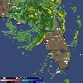
Never been in an 'eye' before and glad it's just a mild tropical storm.
The radar image was definitely a keeper--saved as a bitmap for computer wallpaper.
http://www.intellicast.com/Local/USLoca ... odnav=none
The radar image was definitely a keeper--saved as a bitmap for computer wallpaper.
http://www.intellicast.com/Local/USLoca ... odnav=none
0 likes
Who is online
Users browsing this forum: Google Adsense [Bot] and 87 guests