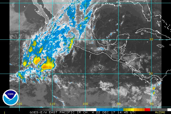
EPAC should develop
Moderator: S2k Moderators
Forum rules
The posts in this forum are NOT official forecasts and should not be used as such. They are just the opinion of the poster and may or may not be backed by sound meteorological data. They are NOT endorsed by any professional institution or STORM2K. For official information, please refer to products from the National Hurricane Center and National Weather Service.
-
Derek Ortt
EPAC should develop
EPAC will most likely become a tropical cyclone either today or tomorrow. I do have a little concern about this if the system develops from the northern cluster as this would bring some heavy rainfall and mudslides to Mexico
0 likes
- cycloneye
- Admin

- Posts: 149702
- Age: 69
- Joined: Thu Oct 10, 2002 10:54 am
- Location: San Juan, Puerto Rico
Yes this system distint to Andres that was a fish storm may be of a big impact in terms of heavy rains in the mexican coast and inland.
0 likes
Visit the Caribbean-Central America Weather Thread where you can find at first post web cams,radars
and observations from Caribbean basin members Click Here
and observations from Caribbean basin members Click Here
- wx247
- S2K Supporter

- Posts: 14279
- Age: 42
- Joined: Wed Feb 05, 2003 10:35 pm
- Location: Monett, Missouri
- Contact:
Although that sat. doesn't show what I am seeing on others, it looks a little better organized. It is also hanging near the coast giving that area some rain. Some of that may work inland a little later.
0 likes
Personal Forecast Disclaimer:
The posts in this forum are NOT official forecast and should not be used as such. They are just the opinion of the poster and may or may not be backed by sound meteorological data. They are NOT endorsed by any professional institution or storm2k.org. For official information, please refer to the NHC and NWS products.
The posts in this forum are NOT official forecast and should not be used as such. They are just the opinion of the poster and may or may not be backed by sound meteorological data. They are NOT endorsed by any professional institution or storm2k.org. For official information, please refer to the NHC and NWS products.
-
Derek Ortt
Looks as if it may make landfall before it will have the chance to develop. A bit surprised it hasn't organized further (though am still trying to figure out how SSD is giving it a too weak classification, the thing looks be be about a 1.5 based upon the weak banding). If the cenetr can become a bit better defined, it may still become a TD before landfall
0 likes
- wx247
- S2K Supporter

- Posts: 14279
- Age: 42
- Joined: Wed Feb 05, 2003 10:35 pm
- Location: Monett, Missouri
- Contact:
I agree Derek. It looks to be too close to Mexico to become a TS, but it might still become a TD.
0 likes
Personal Forecast Disclaimer:
The posts in this forum are NOT official forecast and should not be used as such. They are just the opinion of the poster and may or may not be backed by sound meteorological data. They are NOT endorsed by any professional institution or storm2k.org. For official information, please refer to the NHC and NWS products.
The posts in this forum are NOT official forecast and should not be used as such. They are just the opinion of the poster and may or may not be backed by sound meteorological data. They are NOT endorsed by any professional institution or storm2k.org. For official information, please refer to the NHC and NWS products.
-
chadtm80
ABPZ20 KNHC 012207
TWOEP
TROPICAL WEATHER OUTLOOK
NWS TPC/NATIONAL HURRICANE CENTER MIAMI FL
4 PM PDT SUN JUN 1 2003
FOR THE EASTERN NORTH PACIFIC...EAST OF 140 DEGREES WEST LONGITUDE..
A LARGE TROPICAL DISTURBANCE HAS BECOME A LITTLE BETTER ORGANIZED
ABOUT 120 MILES SOUTH-SOUTHEAST OF ACAPULCO MEXICO. THIS SYSTEM HAS
THE POTENTIAL TO BECOME A TROPICAL DEPRESSION DURING THE NEXT DAY
OR SO...BUT CLOSE PROXIMITY TO LAND WILL LIKELY PREVENT ANY RAPID
DEVELOPMENT FROM OCCURRING. IT IS ALSO POSSIBLE THAT THIS SYSTEM
COULD MOVE INLAND DURING THE NEXT 24 HOURS BEFORE IT IS ABLE TO
DEVELOP INTO A TROPICAL CYCLONE. HOWEVER...HEAVY RAINFALL WILL
CONTINUE TO SPREAD NORTHWESTWARD ALONG THE SOUTH-CENTRAL COAST OF
MEXICO. FLOODING AND MUD SLIDES WILL BE POSSIBLE FROM PUERTO ANGEL
TO ACAPULCO AS THE SYSTEM MOVES SLOWLY NORTHWESTWARD.

0 likes
- cycloneye
- Admin

- Posts: 149702
- Age: 69
- Joined: Thu Oct 10, 2002 10:54 am
- Location: San Juan, Puerto Rico
Time is running out for it to be a Td because it is closing on the coast but still it is possible that it may be a TD just before it arrives on the coast but for sure heavy rains for that area.
0 likes
Visit the Caribbean-Central America Weather Thread where you can find at first post web cams,radars
and observations from Caribbean basin members Click Here
and observations from Caribbean basin members Click Here
- PTrackerLA
- Category 5

- Posts: 5281
- Age: 42
- Joined: Thu Oct 10, 2002 8:40 pm
- Location: Lafayette, LA
- wx247
- S2K Supporter

- Posts: 14279
- Age: 42
- Joined: Wed Feb 05, 2003 10:35 pm
- Location: Monett, Missouri
- Contact:
Looks like this thing may come onshore before it becomes a TD just by looking at the latest sat. image. Looks like some flooding rains for areas east of the center.
0 likes
Personal Forecast Disclaimer:
The posts in this forum are NOT official forecast and should not be used as such. They are just the opinion of the poster and may or may not be backed by sound meteorological data. They are NOT endorsed by any professional institution or storm2k.org. For official information, please refer to the NHC and NWS products.
The posts in this forum are NOT official forecast and should not be used as such. They are just the opinion of the poster and may or may not be backed by sound meteorological data. They are NOT endorsed by any professional institution or storm2k.org. For official information, please refer to the NHC and NWS products.
Who is online
Users browsing this forum: No registered users and 212 guests
