Tropical Depression Beatriz,It has dissipated

This is the general tropical discussion area. Anyone can take their shot at predicting a storms path.

Moderator: S2k Moderators

Forum rules

The posts in this forum are NOT official forecasts and should not be used as such. They are just the opinion of the poster and may or may not be backed by sound meteorological data. They are NOT endorsed by any professional institution or STORM2K. For official information, please refer to products from the National Hurricane Center and National Weather Service.

Help Support Storm2K
Message
Author
User avatar
cycloneye
Admin
Admin
Posts: 148503
Age: 69
Joined: Thu Oct 10, 2002 10:54 am
Location: San Juan, Puerto Rico

Tropical Depression Beatriz,It has dissipated

#1 Postby cycloneye » Mon Jun 20, 2005 7:25 am

http://tcweb.fnmoc.navy.mil/tc-bin/tc_home.cgi

After Adrian came onshore in CentralAmerica for more than a month it has been quiet but it appears that something may be brewing SW of the Gulf of TEHUANTEPEC.

Image

Image

Shear is not too strong in the area.

But distinct of Adrian which moved eastward this disturbance will move westward away from land.
Last edited by cycloneye on Fri Jun 24, 2005 9:45 am, edited 41 times in total.
0 likes   

User avatar
Hurricanehink
S2K Supporter
S2K Supporter
Posts: 2044
Joined: Sun Nov 16, 2003 2:05 pm
Location: New Jersey

#2 Postby Hurricanehink » Mon Jun 20, 2005 7:39 am

BOO! :grr: The EPAC can't get the lead this quickly.
0 likes   

User avatar
cycloneye
Admin
Admin
Posts: 148503
Age: 69
Joined: Thu Oct 10, 2002 10:54 am
Location: San Juan, Puerto Rico

#3 Postby cycloneye » Mon Jun 20, 2005 7:43 am

Hurricanehink wrote:BOO! :grr: The EPAC can't get the lead this quickly.


:lol: :lol: You are keeping score as HurricaneFloyd does. :lol: :lol:
0 likes   
Visit the Caribbean-Central America Weather Thread where you can find at first post web cams,radars
and observations from Caribbean basin members Click Here

User avatar
cycloneye
Admin
Admin
Posts: 148503
Age: 69
Joined: Thu Oct 10, 2002 10:54 am
Location: San Juan, Puerto Rico

#4 Postby cycloneye » Mon Jun 20, 2005 8:27 am

Image

First visible pics shows what appears a weak low trying to get it's act together.

Image


Image
Last edited by cycloneye on Mon Jun 20, 2005 9:21 am, edited 2 times in total.
0 likes   

Scorpion

#5 Postby Scorpion » Mon Jun 20, 2005 8:48 am

Usually the EPAC is well ahead of the game in June, but the Atl will catch up in August.
0 likes   

User avatar
cycloneye
Admin
Admin
Posts: 148503
Age: 69
Joined: Thu Oct 10, 2002 10:54 am
Location: San Juan, Puerto Rico

#6 Postby cycloneye » Mon Jun 20, 2005 9:18 am

TROPICAL DEPRESSION INVEST (EP912005) ON 20050620 1200 UTC

...00 HRS... ...12 HRS... ...24 HRS... ...36 HRS...
050620 1200 050621 0000 050621 1200 050622 0000

LAT LON LAT LON LAT LON LAT LON
BAMD 14.0N 98.0W 14.4N 99.8W 15.1N 102.2W 15.9N 105.0W
BAMM 14.0N 98.0W 14.5N 99.7W 14.8N 102.1W 15.6N 105.0W
LBAR 14.0N 98.0W 14.3N 99.6W 15.2N 101.8W 16.4N 104.3W
SHIP 20KTS 26KTS 33KTS 41KTS
DSHP 20KTS 26KTS 33KTS 41KTS

...48 HRS... ...72 HRS... ...96 HRS... ..120 HRS...
050622 1200 050623 1200 050624 1200 050625 1200

LAT LON LAT LON LAT LON LAT LON
BAMD 16.8N 108.0W 18.1N 113.6W 18.4N 118.3W 19.0N 120.9W
BAMM 16.4N 108.2W 17.5N 114.8W 17.6N 120.0W 17.4N 123.1W
LBAR 17.6N 106.7W 20.4N 111.0W 22.5N 112.9W 23.9N 112.6W
SHIP 46KTS 47KTS 39KTS 32KTS
DSHP 46KTS 47KTS 39KTS 32KTS

...INITIAL CONDITIONS...
LATCUR = 14.0N LONCUR = 98.0W DIRCUR = 270DEG SPDCUR = 6KT
LATM12 = 14.0N LONM12 = 96.8W DIRM12 = 270DEG SPDM12 = 6KT
LATM24 = 14.0N LONM24 = 95.6W
WNDCUR = 20KT RMAXWD = 0NM WNDM12 = 20KT
CENPRS = 1008MB OUTPRS = 1010MB OUTRAD = 150NM SDEPTH = M
RD34NE = 0NM RD34SE = 0NM RD34SW = 0NM RD34NW = 0NM


All the tropical models go away from land distint from Adrian.Will Beatriz form from this?Well the models support development.
0 likes   

User avatar
cycloneye
Admin
Admin
Posts: 148503
Age: 69
Joined: Thu Oct 10, 2002 10:54 am
Location: San Juan, Puerto Rico

#7 Postby cycloneye » Mon Jun 20, 2005 11:46 am

ABPZ20 KNHC 201637
TWOEP
TROPICAL WEATHER OUTLOOK
NWS TPC/NATIONAL HURRICANE CENTER MIAMI FL
10 AM PDT MON JUN 20 2005

FOR THE EASTERN NORTH PACIFIC...EAST OF 140 DEGREES WEST LONGITUDE.

AN AREA OF DISTURBED WEATHER CENTERED A COUPLE HUNDRED MILES SOUTH
OF ACAPULCO HAS BECOME BETTER ORGANIZED SINCE YESTERDAY.
UPPER-LEVEL WINDS ARE FAVORABLE FOR FURTHER DEVELOPMENT...AND A
TROPICAL DEPRESSION COULD FORM DURING THE NEXT DAY OR TWO AS THE
SYSTEM MOVES WESTWARD AT 5 TO 10 MPH.

ELSEWHERE...TROPICAL STORM FORMATION IS NOT EXPECTED THROUGH
TUESDAY.

FORECASTER KNABB/FRANKLIN


It looks like the EPAC will have some action in the next couple of days for us to track.

Image
0 likes   
Visit the Caribbean-Central America Weather Thread where you can find at first post web cams,radars
and observations from Caribbean basin members Click Here

User avatar
HURAKAN
Professional-Met
Professional-Met
Posts: 46086
Age: 38
Joined: Thu May 20, 2004 4:34 pm
Location: Key West, FL
Contact:

#8 Postby HURAKAN » Mon Jun 20, 2005 11:49 am

SPECIAL FEATURE:

LOW PRESSURE IS CENTERED 13N97W 1006 MB MOVING WEST 10 KNOTS.
THIS SYSTEM HAS DEVELOPED SIGNIFICANT AMOUNTS OF CONVECTION
WITHIN 180 NM IN THE NW SEMICIRCLE. THE NATIONAL WEATHER
SERVICE GLOBAL FORECAST SYSTEM COMPUTER MODEL DEVELOPS THE LOW
OVER THE NEXT COUPLE OF DAYS AND THIS SYSTEM COULD DEVELOP INTO
A TROPICAL CYCLONE.
0 likes   

User avatar
cycloneye
Admin
Admin
Posts: 148503
Age: 69
Joined: Thu Oct 10, 2002 10:54 am
Location: San Juan, Puerto Rico

#9 Postby cycloneye » Mon Jun 20, 2005 11:51 am

Definitly it looks like it will be Beatriz as conditions are favorable.
0 likes   
Visit the Caribbean-Central America Weather Thread where you can find at first post web cams,radars
and observations from Caribbean basin members Click Here

User avatar
cycloneye
Admin
Admin
Posts: 148503
Age: 69
Joined: Thu Oct 10, 2002 10:54 am
Location: San Juan, Puerto Rico

#10 Postby cycloneye » Mon Jun 20, 2005 12:03 pm

TROPICAL STORM FORECAST TO DEVELOP AFTER 36 HOURS

FORECAST POSITION AT T+36 : 13.2N 101.4W


VERIFYING TIME POSITION STRENGTH TENDENCY

-------------- -------- -------- --------

12UTC 21.06.2005 13.2N 101.4W WEAK

00UTC 22.06.2005 13.1N 103.8W WEAK INTENSIFYING SLIGHTLY

12UTC 22.06.2005 13.6N 106.1W WEAK LITTLE CHANGE

00UTC 23.06.2005 13.7N 108.9W WEAK LITTLE CHANGE

12UTC 23.06.2005 13.9N 110.4W WEAK WEAKENING SLIGHTLY

00UTC 24.06.2005 14.2N 111.8W WEAK WEAKENING SLIGHTLY

12UTC 24.06.2005 14.2N 112.3W WEAK WEAKENING SLIGHTLY

00UTC 25.06.2005 BELOW TROPICAL STORM STRENGTH


UKMET is on board.
0 likes   
Visit the Caribbean-Central America Weather Thread where you can find at first post web cams,radars
and observations from Caribbean basin members Click Here

User avatar
dhweather
S2K Supporter
S2K Supporter
Posts: 6199
Joined: Sat Aug 14, 2004 9:29 pm
Location: Heath, TX
Contact:

#11 Postby dhweather » Mon Jun 20, 2005 12:04 pm

Aw man, the EPAC is going ot get the lead again!
0 likes   

User avatar
cycloneye
Admin
Admin
Posts: 148503
Age: 69
Joined: Thu Oct 10, 2002 10:54 am
Location: San Juan, Puerto Rico

#12 Postby cycloneye » Mon Jun 20, 2005 12:30 pm

dhweather wrote:Aw man, the EPAC is going ot get the lead again!


EPAC may be 2/1 in the next couple of days but briefly as it looks like the atlantic will tie soon. :)
0 likes   
Visit the Caribbean-Central America Weather Thread where you can find at first post web cams,radars
and observations from Caribbean basin members Click Here

User avatar
EyeOfTheStorm
Tropical Low
Tropical Low
Posts: 26
Joined: Mon Aug 09, 2004 2:20 pm
Location: Texas

#13 Postby EyeOfTheStorm » Mon Jun 20, 2005 12:57 pm

Why does anyone care about the EPAC ????
0 likes   

User avatar
cycloneye
Admin
Admin
Posts: 148503
Age: 69
Joined: Thu Oct 10, 2002 10:54 am
Location: San Juan, Puerto Rico

#14 Postby cycloneye » Mon Jun 20, 2005 12:58 pm

Image

Definitly organization is improving hour by hour.
0 likes   

Derek Ortt

#15 Postby Derek Ortt » Mon Jun 20, 2005 1:25 pm

it still is very poorly organized. Just checked a close-up visible loop on GARP and it shows that the LLC is about 100NM east of the deep convective area. Seems as if there is some decent easterly wind shear. Development is likely to be slow
0 likes   

User avatar
vbhoutex
Storm2k Executive
Storm2k Executive
Posts: 29133
Age: 74
Joined: Wed Oct 09, 2002 11:31 pm
Location: Cypress, TX
Contact:

#16 Postby vbhoutex » Mon Jun 20, 2005 1:26 pm

EyeOfTheStorm wrote:Why does anyone care about the EPAC ????


Because we enjoy the weather worldwide and whether we like it or not, sometimes what happens in the EPAC has a direct impact on the Atlantic Basin.
0 likes   

User avatar
cycloneye
Admin
Admin
Posts: 148503
Age: 69
Joined: Thu Oct 10, 2002 10:54 am
Location: San Juan, Puerto Rico

#17 Postby cycloneye » Mon Jun 20, 2005 2:12 pm

TROPICAL DEPRESSION INVEST (EP912005) ON 20050620 1800 UTC

...00 HRS... ...12 HRS... ...24 HRS... ...36 HRS...
050620 1800 050621 0600 050621 1800 050622 0600

LAT LON LAT LON LAT LON LAT LON
BAMD 13.3N 98.7W 13.7N 100.7W 14.4N 103.3W 15.2N 106.4W
BAMM 13.3N 98.7W 13.6N 100.5W 14.2N 103.1W 15.1N 106.2W
LBAR 13.3N 98.7W 13.7N 100.3W 14.5N 102.5W 15.7N 105.2W
SHIP 20KTS 26KTS 34KTS 41KTS
DSHP 20KTS 26KTS 34KTS 41KTS

...48 HRS... ...72 HRS... ...96 HRS... ..120 HRS...
050622 1800 050623 1800 050624 1800 050625 1800

LAT LON LAT LON LAT LON LAT LON
BAMD 16.2N 109.8W 17.1N 116.4W 17.0N 122.2W 16.9N 126.1W
BAMM 16.0N 109.6W 17.2N 116.6W 17.1N 122.0W 16.7N 125.1W
LBAR 16.9N 108.1W 19.6N 113.0W 21.2N 116.1W 18.0N 122.1W
SHIP 47KTS 47KTS 40KTS 32KTS
DSHP 47KTS 47KTS 40KTS 32KTS

...INITIAL CONDITIONS...
LATCUR = 13.3N LONCUR = 98.7W DIRCUR = 270DEG SPDCUR = 6KT
LATM12 = 13.3N LONM12 = 97.5W DIRM12 = 270DEG SPDM12 = 6KT
LATM24 = 13.3N LONM24 = 95.7W
WNDCUR = 20KT RMAXWD = 0NM WNDM12 = 20KT
CENPRS = 1008MB OUTPRS = 1010MB OUTRAD = 150NM SDEPTH = M
RD34NE = 0NM RD34SE = 0NM RD34SW = 0NM RD34NW = 0NM


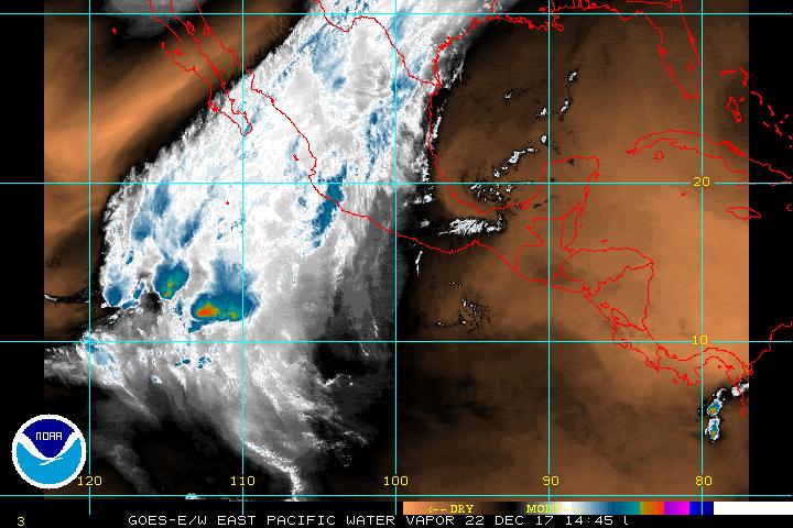
The 18:00 UTC model guidance for 91E.
0 likes   
Visit the Caribbean-Central America Weather Thread where you can find at first post web cams,radars
and observations from Caribbean basin members Click Here

Matt-hurricanewatcher

#18 Postby Matt-hurricanewatcher » Mon Jun 20, 2005 2:19 pm

Looks like we we will have tropical depression soon. 8-)
0 likes   

User avatar
dhweather
S2K Supporter
S2K Supporter
Posts: 6199
Joined: Sat Aug 14, 2004 9:29 pm
Location: Heath, TX
Contact:

#19 Postby dhweather » Mon Jun 20, 2005 2:28 pm

I'd guess within 36-48 hours.
0 likes   

User avatar
cycloneye
Admin
Admin
Posts: 148503
Age: 69
Joined: Thu Oct 10, 2002 10:54 am
Location: San Juan, Puerto Rico

#20 Postby cycloneye » Mon Jun 20, 2005 5:38 pm

Tropical Weather Outlook


Statement as of 4:00 PM PDT on June 20, 2005


For the eastern North Pacific...east of 140 degrees west longitude.

An area of disturbed weather centered about 225 miles south of
Acapulco continues to become better organized. Upper-level winds
are favorable for further development...and a tropical depression
could form during the next day or two as the system moves westward
about 10 mph.

Elsewhere...tropical storm formation is not expected through
Tuesday.

Forecaster Beven
$$


Image

It does not look concentrated in terms of deep convection at this time but easterly shear is not too strong to not allow this disturbance to become a TD and later Tropical Storm Beatriz in the next couple of days.
0 likes   
Visit the Caribbean-Central America Weather Thread where you can find at first post web cams,radars
and observations from Caribbean basin members Click Here


Return to “Talkin' Tropics”

Who is online

Users browsing this forum: chaser1, Google Adsense [Bot] and 534 guests