

Don't think this will be come a TS, but in interesting to watch nonetheless.
http://www.erh.noaa.gov/radar/loop/DS.p ... kmhx.shtml
Interesting Swirl Along the NC Coast
Moderator: S2k Moderators
Forum rules

The posts in this forum are NOT official forecasts and should not be used as such. They are just the opinion of the poster and may or may not be backed by sound meteorological data. They are NOT endorsed by any professional institution or STORM2K. For official information, please refer to products from the National Hurricane Center and National Weather Service.

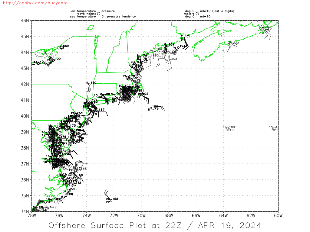
I believe low pressure did form last night. Buoys are clearly showing a closed LLC now!!
http://weather.noaa.gov/radar/loop/DS.p ... kmhx.shtml
http://coolwx.com/buoydata/data/t-02/atl-neus.png
http://coolwx.com/buoydata/data/t-01/atl-neus.png
http://weather.noaa.gov/radar/loop/DS.p ... kmhx.shtml
http://coolwx.com/buoydata/data/t-02/atl-neus.png
http://coolwx.com/buoydata/data/t-01/atl-neus.png
0 likes
SHORT TERM FORECAST
NATIONAL WEATHER SERVICE NEWPORT/MOREHEAD CITY NC
724 AM EDT SUN JUN 26 2005
AMZ130-135-150-152-154-156-NCZ045>047-080-081-093>095-103-261330-
ALBEMARLE SOUND-PAMLICO SOUND-
S OF CURRITUCK BEACH LIGHT TO OREGON INLET NC OUT 20 NM-
S OF OREGON INLET TO CAPE HATTERAS NC OUT 20 NM-
S OF CAPE HATTERAS TO OCRACOKE INLET NC OUT 20 NM
INCLUDING THE MONITOR NATIONAL MARINE SANCTUARY-
S OF OCRACOKE INLET TO CAPE LOOKOUT NC OUT 20 NM-WASHINGTON-
TYRRELL-MAINLAND DARE-BEAUFORT-MAINLAND HYDE-CRAVEN-PAMLICO-
CARTERET-OUTER BANKS DARE-
INCLUDING THE CITIES OF...PLYMOUTH...COLUMBIA...WASHINGTON...
RIVER ROAD...NEW BERN...HAVELOCK...ORIENTAL...ALLIANCE...
BAYBORO...ARAPAHOE...MINNESOTT BEACH...VANDEMERE...STONEWALL...
MOREHEAD CITY...BEAUFORT...EMERALD ISLE...NEWPORT...
KILL DEVIL HILLS...KITTY HAWK...NAGS HEAD...SOUTHERN SHORES
724 AM EDT SUN JUN 26 2005
.NOW...AN AREA OF LOW PRESSURE LOCATED OFF THE COAST IS PRODUCING
AREAS OF MODERATE TO HEAVY SHOWERS AND ISOLATED THUNDERSTORMS...
WHICH WILL CONTINUE TO MOVE ONSHORE THROUGHOUT THE MORNING. THE
HEAVIEST RAIN...LOCATED EAST OF A LINE FROM COLUMBIA TO HOBUCKEN
WILL CONTINUE SPREADING NORTHWEST TO ALONG THE HIGHWAY 17
CORRIDOR THROUGH 930 AM. RESIDENTS CAN EXPECT RAINFALL AMOUNTS OF
1/2 TO 1 INCH...WITH ISOLATED AMOUNTS UP TO 2 INCHES POSSIBLE.
LOCALIZED FLOODING OF LOW LYING AND POOR DRAINAGE AREAS WILL BE
POSSIBLE ESPECIALLY ACROSS DARE...HYDE...BEAUFORT...TYRRELL...AND
WASHINGTON COUNTIES. WINDS WILL GUST TO 30 KNOTS ACROSS THE
OUTER BANKS AND THE ADJACENT COASTAL WATERS INCLUDING THE PAMLICO
SOUND...IN THE HEAVIER SHOWERS.
0 likes
drezee wrote:I believe low pressure did form last night. Buoys are clearly showing a closed LLC now!!
http://weather.noaa.gov/radar/loop/DS.p ... kmhx.shtml
http://coolwx.com/buoydata/data/t-02/atl-neus.png
http://coolwx.com/buoydata/data/t-01/atl-neus.png
That site won't let you hot link.
0 likes
717
WHXX01 KWBC 261228
CHGHUR
DISCLAIMER...NUMERICAL MODELS ARE SUBJECT TO LARGE ERRORS.
PLEASE REFER TO TPC/NHC OFFICIAL FORECASTS FOR TROPICAL CYCLONES.
.....THE FOLLOWING IS A TEST MESSAGE.....
NATIONAL HURRICANE CENTER NORTH ATLANTIC OBJECTIVE AIDS FOR
TROPICAL DEPRESSION INVEST (AL942005) ON 20050626 1200 UTC
...00 HRS... ...12 HRS... ...24 HRS... ...36 HRS...
050626 1200 050627 0000 050627 1200 050628 0000
LAT LON LAT LON LAT LON LAT LON
BAMD 35.1N 76.2W 36.8N 76.5W 38.0N 76.4W 39.1N 76.1W
BAMM 35.1N 76.2W 36.4N 76.8W 37.6N 77.2W 38.7N 77.3W
A98E 35.1N 76.2W 37.6N 76.5W 39.2N 75.6W 40.3N 74.0W
LBAR 35.1N 76.2W 37.1N 76.4W 38.7N 76.4W 39.9N 75.8W
SHIP 25KTS 27KTS 27KTS 26KTS
DSHP 25KTS 25KTS 27KTS 28KTS
...48 HRS... ...72 HRS... ...96 HRS... ..120 HRS...
050628 1200 050629 1200 050630 1200 050701 1200
LAT LON LAT LON LAT LON LAT LON
BAMD 40.3N 75.3W 42.8N 70.2W 43.9N 61.1W 44.5N 51.8W
BAMM 40.1N 77.1W 43.3N 72.9W 45.2N 64.2W 46.7N 54.1W
A98E 40.8N 72.5W 40.6N 71.1W 42.9N 64.7W 46.4N 50.4W
LBAR 40.8N 74.6W 42.2N 69.5W 41.2N 63.1W 38.6N 58.8W
SHIP 24KTS 23KTS 22KTS 17KTS
DSHP 29KTS 30KTS 29KTS 29KTS
...INITIAL CONDITIONS...
LATCUR = 35.1N LONCUR = 76.2W DIRCUR = 350DEG SPDCUR = 14KT
LATM12 = 32.1N LONM12 = 75.7W DIRM12 = 351DEG SPDM12 = 13KT
LATM24 = 29.8N LONM24 = 75.5W
WNDCUR = 25KT RMAXWD = 35NM WNDM12 = 25KT
CENPRS = 1013MB OUTPRS = 1016MB OUTRAD = 150NM SDEPTH = D
RD34NE = 0NM RD34SE = 0NM RD34SW = 0NM RD34NW = 0NM
.....THE ABOVE HAS BEEN A TEST MESSAGE.....
0 likes

-
Matt-hurricanewatcher
-
Matt-hurricanewatcher
What ever it was it made landfall. The center by model placement was right in the center. 35/76.5
So we got 35 mph winds out of the northeast over the northeast quad. While a ship report(c1kn7) over the southwest side of the system. With the wind moving out of that one from the southwest.
So we got 35 mph winds out of the northeast over the northeast quad. While a ship report(c1kn7) over the southwest side of the system. With the wind moving out of that one from the southwest.
Last edited by Matt-hurricanewatcher on Sun Jun 26, 2005 8:28 am, edited 1 time in total.
0 likes
-
Trader Ron

- S2K Supporter

- Posts: 928
- Joined: Tue Jul 22, 2003 7:25 pm
- Location: Naples,Fl
- Contact:
TraderRon,
That would be statisically the most probable solution given the time of year and other historical factors. Not to mention the fact that the ULL had to either turn tropical or get out of the way in time. If any person said that any tropical disturbance over a given season would not develop, then they would be right over 90% of the time on average.
That would be statisically the most probable solution given the time of year and other historical factors. Not to mention the fact that the ULL had to either turn tropical or get out of the way in time. If any person said that any tropical disturbance over a given season would not develop, then they would be right over 90% of the time on average.
0 likes
-
Trader Ron
- S2K Supporter
- Posts: 928
- Joined: Tue Jul 22, 2003 7:25 pm
- Location: Naples,Fl
- Contact:
-
Trader Ron
- S2K Supporter
- Posts: 928
- Joined: Tue Jul 22, 2003 7:25 pm
- Location: Naples,Fl
- Contact:
-
Matt-hurricanewatcher
I don't think this will mean anything to you but take a look.
Southwest quad
http://www.ndbc.noaa.gov/station_page.php?station=clkn7
Northern quad
http://www.ndbc.noaa.gov/station_page.php?station=ducn7
Southeast quad
http://www.ndbc.noaa.gov/station_page.php?station=41025
Southwest quad
http://www.ndbc.noaa.gov/station_page.php?station=clkn7
Northern quad
http://www.ndbc.noaa.gov/station_page.php?station=ducn7
Southeast quad
http://www.ndbc.noaa.gov/station_page.php?station=41025
0 likes

-
Matt-hurricanewatcher
Who is online
Users browsing this forum: bird, pepecool20 and 54 guests