El nino still lingers but fading completly soon
Moderator: S2k Moderators
Forum rules

The posts in this forum are NOT official forecasts and should not be used as such. They are just the opinion of the poster and may or may not be backed by sound meteorological data. They are NOT endorsed by any professional institution or STORM2K. For official information, please refer to products from the National Hurricane Center and National Weather Service.
-
cycloneye

- Admin

- Posts: 149696
- Age: 69
- Joined: Thu Oct 10, 2002 10:54 am
- Location: San Juan, Puerto Rico
El nino still lingers but fading completly soon
The summer pattern has not set in just yet because of some lingering effects from el nino that is slowly going away as neutral to la nina conditions take over in the pacific.I think Stormsfury has said that the summer pattern lags behind one month and I agree with him on that but once the normal pattern arrives in the atlantic we will see the hurricane season becoming active but then comes the MJO factor that comes and goes in the 6 months of the season.I think that TWW said that the negative phase of the MJO will come by mid to late July but will Bill wait until then?
0 likes
Visit the Caribbean-Central America Weather Thread where you can find at first post web cams,radars
and observations from Caribbean basin members Click Here
and observations from Caribbean basin members Click Here
-
Stormsfury

- Category 5

- Posts: 10549
- Age: 53
- Joined: Wed Feb 05, 2003 6:27 pm
- Location: Summerville, SC
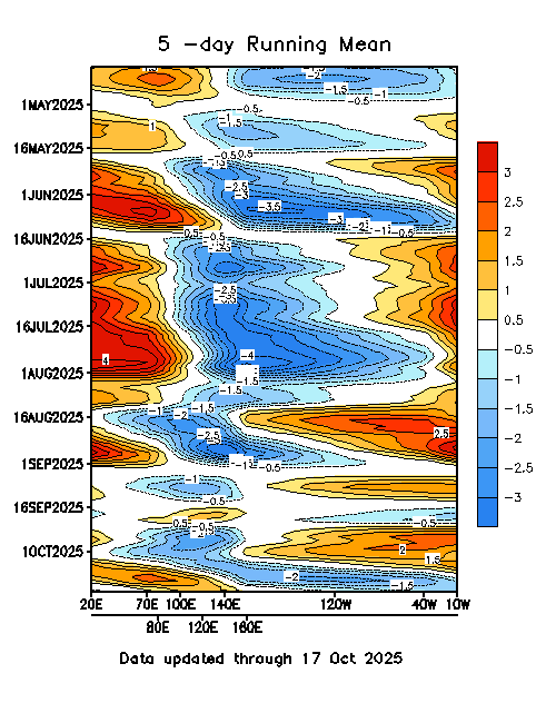
These are some current datasets for Pacific SST's and the MJO 5/15 running means.
Pacific SST's and SST Anomalies.


5 Day Running Mean of the MJO
15 Day Running Mean of the MJO
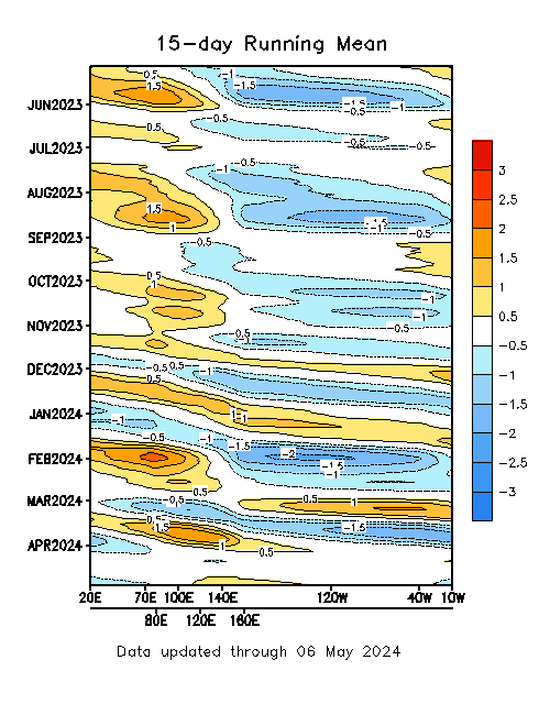
If the pattern transitions like I think it will (and AE Mike) ... and the MJO transitions like Supercane, and TWW expect ... the two could coincide together and could make July an interesting month ...
Pacific SST's and SST Anomalies.
5 Day Running Mean of the MJO
15 Day Running Mean of the MJO
If the pattern transitions like I think it will (and AE Mike) ... and the MJO transitions like Supercane, and TWW expect ... the two could coincide together and could make July an interesting month ...
0 likes
-
cycloneye
- Admin
- Posts: 149696
- Age: 69
- Joined: Thu Oct 10, 2002 10:54 am
- Location: San Juan, Puerto Rico
Thanks SF for those maps and grafics.And let's see if the pattern sets up as TWW,Supercane,Mike and SF haved said and see Bill by july or sooner.
0 likes
Visit the Caribbean-Central America Weather Thread where you can find at first post web cams,radars
and observations from Caribbean basin members Click Here
and observations from Caribbean basin members Click Here
-
Anonymous
Everything is pointing towards our next TS not coming until the second half of July. El Nino is still producing residual influence on the pattern, including higher front frequency, drier Atlantic air, and like Stormsfury said, pattern lagging. All of this should prevent anything from forming anywhere in the Atlantic anytime soon. A negative MJO is still present, but come the middle of the month a dry phase will move in. This will only hamper the environment even more for another 20 days or so. The next favorable MJO will move in during the seconf half of July. It is by this time that El Nino's affects will diminish and La Nina will start to kick in. Just watch...I bet we will go another 35 days or more without seeing Bill. And you can quote me on that.
0 likes
-
cycloneye
- Admin
- Posts: 149696
- Age: 69
- Joined: Thu Oct 10, 2002 10:54 am
- Location: San Juan, Puerto Rico
If that pans out SC then many people will say that the season is boring or dud LOl.
0 likes
Visit the Caribbean-Central America Weather Thread where you can find at first post web cams,radars
and observations from Caribbean basin members Click Here
and observations from Caribbean basin members Click Here
-
chadtm80
-
Stormsfury
- Category 5
- Posts: 10549
- Age: 53
- Joined: Wed Feb 05, 2003 6:27 pm
- Location: Summerville, SC
-
Anonymous
Heck, look at all of these BUSY seasons that have had extremely late starts...
1926: First named storm formed on Jul 22
Season ended up with 11/8/6
1950: First named storm formed on Aug 16
Season ended up with 13/11/8
1953: Second named storm formed on Aug 11
Season ended up with 14/6/4
1955: Second named storm formed on Jul 31
Season ended up with 12/9/6
1961: Second named storm formed on Sep 2
Season ended up with 11/8/7
1969: First named storm formed on 25 Jul
Season ended up with 17/12/5
1988: First named storm formed on Aug 5
Season ended up with 12/5/3
1998: First named storm formed on July 27
Season ended up with 14/10/3
1999: Second named storm formed on Aug 18
Season ended up with 12/8/5
2000: First named storm formed on Aug 4
Season ended up with 14/8/3
2001: Second named storm formed on Aug 2
Season ended up with 15/9/4
0 likes


>>Everything is pointing towards our next TS not coming until the second half of July.
I'm not sure either way. We could have a pattern-generated close-in TS/TD from a trof split or behind an amplification after the zonal pattern likely to set up for the next several days. I think it's too hard to call right now.
>>The summer pattern has not set in just yet because of some lingering effects from el nino that is slowly going away as neutral to la nina conditions take over in the pacific
This is true. There are still pulses of El Nino pushing back against the developing La Nina conditions off S.A. From some web readings, I understand that the cooler water is fairly deep off the S.A. coast, so I don't think whatever's left in the El Nino will do much but prevent a stronger La Nina. Some signs point to a short lived or weak-moderate event, but like always in weather, you can never be sure.
FWIW, the Southern Oscilation Index had been strongly El Nino a week or so ago, came back up to neutral and at last check, was back El Nino. Lemme see if I can find a link to the plots:
Here's a good explanation of the phenomina from Austraila:
http://www.vision.net.au/~daly/elnino.htm
Here are the 30 day values from Queensland, Austrailia:
http://www.longpaddock.qld.gov.au/Seaso ... SOIValues/
This tells me the El Nino still has a bit of a fight left in it in the western zones (3 & 4?).
Steve
0 likes
-
cycloneye
- Admin
- Posts: 149696
- Age: 69
- Joined: Thu Oct 10, 2002 10:54 am
- Location: San Juan, Puerto Rico
Steve especially el nino 4 area as this data shows.
http://www.pmel.noaa.gov/tao/jsdisplay/ ... y_ps32.gif
http://www.pmel.noaa.gov/tao/jsdisplay/ ... y_ps32.gif
0 likes
Visit the Caribbean-Central America Weather Thread where you can find at first post web cams,radars
and observations from Caribbean basin members Click Here
and observations from Caribbean basin members Click Here
-
Stormsfury
- Category 5
- Posts: 10549
- Age: 53
- Joined: Wed Feb 05, 2003 6:27 pm
- Location: Summerville, SC
-
Anonymous
TWW,
Do you have a prediction on the strength, scope and longevity of the coming La Nina? I'm wondering if it's going to be all that strong across the equatorial Pacific when it reaches its peak. I'm also doubtful that it's going to be anything like the 1998-2000 event. We had some terrible drought conditions here those 3 years (I'm sure I don't have to tell you). My dad's front lawn is still half dead from it. The 2 big magnolia trees he has, which co-existed with the lawn from 1967-1998 just spread feeder roots everywhere trying to get water. He was too busy to turn on the sprinklers every day like I warned him to. But in all honesty, that La Nina seems to have been a reaction to the previous, intense El Nino. And while that idea may not always hold water, coming out of a somewhat weak El Nino period, I just can't see a vicious La Nina on its heels. But since you spend so much time on this stuff, your opinion is important to me.
Steve
0 likes
-
Anonymous
Thanks Steve! We're expecting a weak to moderate La Nina event, similar to the strength of the last El Nino event. An event similar to 1998 is almost out of the question. La Nina will likely persist through at least December, which is usually the time of year when ENSO episodes have the tendency to weaken. Sometimes ENSO events can last for an additional year. But its too early to say whether or not that will happen this time.
0 likes

Who is online
Users browsing this forum: zal0phus and 222 guests