
Personal Disclaimer: In addition, all official information can be found at http://www.nhc.noaa.gov/ . For all emergency management information, you can go to your local NWS office website by following the appropriate link at http://www.srh.noaa.gov/ or by monitoring your local television station.
Graphics Disclaimer: The forecast graphic provided in this forecast is not endorsed by S2K, NHC, NOAA, or any other forecasting organization.
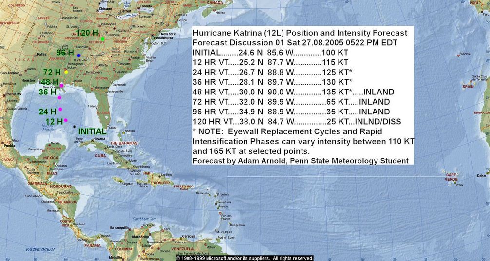
0546 PM EDT 27.08.2005
During the past 24 Hours, Katrina became better organized and strengthened into a category 3 hurricane, followed by an eyewall replacement cycle. The path of Katrina has curved more to the west with a few west northwesterly jogs. Latest satellite pictures show Katrina beginning to reorganize with a much improved structure. In terms of strength, expect Katrina to begin to restrengthen within the next few hours. Water temperatures in the Gulf of Mexico are very high...90 degrees and above. The greatest heat content, in fact, is just offshore the Louisiana coast. Strengthening to well within category 5 status is certainly not out of the question, as shown in my forecast, however, I am not comfortable yet making my intensity forecast within the category 5 range. The two variables most problematic in determining the intensity at landfall are eyewall replacement cycles and the shear that will come from the north...but it appears that Katrina may make it to the coastline of Louisiana before the shear begins to impact her. In terms of position it is important that EVERYONE within the watch area monitor the progress of Katrina as it is very possible that an unexpected change in track may occur. But right now, it appears that Katrina will be tracking over the metropolitan New Orleans area as a very strong and devastating storm. I urge everyone in this area to monitor their local emergency management officials and follow ALL preparation and evacuation instructions given to you. In summary, this storm is a very dangerous and deadly storm and has the potential to cause catastropic destruction and loss of life in any area that it makes landfall. Do NOT take this situation lightly as you may be putting your life in danger.
Position and Intensity Forecast Graphic:
*END


