Storm2k Outlook updated 5pm..

This is the general tropical discussion area. Anyone can take their shot at predicting a storms path.

Moderator: S2k Moderators

Forum rules

The posts in this forum are NOT official forecasts and should not be used as such. They are just the opinion of the poster and may or may not be backed by sound meteorological data. They are NOT endorsed by any professional institution or STORM2K. For official information, please refer to products from the National Hurricane Center and National Weather Service.

Help Support Storm2K
Message
Author
chadtm80

Storm2k Outlook updated 5pm..

#1 Postby chadtm80 » Sat Jun 28, 2003 8:23 am

Image

Storm2k Tropical Outlook 6/28/03 by David (vbhoutex) :rarrow: http://storm2k.org/Weather-Central/Trop ... ropics.htm :larrow:

Cuba and surrounding Radars :rarrow: http://www.storm2k.org/Weather-Central/ ... aRadar.htm :larrow:
Last edited by chadtm80 on Sat Jun 28, 2003 5:07 pm, edited 4 times in total.
0 likes   

User avatar
wxman57
Moderator-Pro Met
Moderator-Pro Met
Posts: 22978
Age: 67
Joined: Sat Jun 21, 2003 8:06 pm
Location: Houston, TX (southwest)

Not Sure About Energy Split

#2 Postby wxman57 » Sat Jun 28, 2003 8:35 am

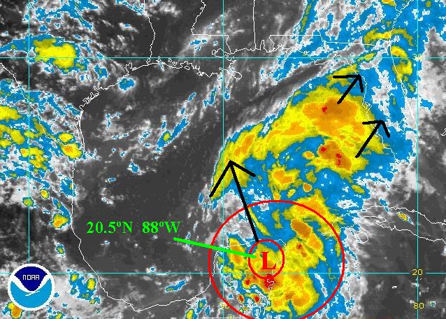
I noticed the GFS splitting this thing in two as well, taking one weak circulation inland over the western FL Panhandle on Monday morning and another piece moving NW toward the TX coast. Seems a bit strange to me. I do like what the GFS is doing with the moisture east of the Yucatan, however - driving it north toward Apalachicola. I think there may be a 50-60% shot at it developing into a sheared TD just prior to landfall Monday, kind of like Bertha last year. I don't think Bertha should have ever been upgraded to a minimal TS based on a single buoy report of a 35kt wind that wasn't necessarily for a full minute. Anyway, I think this will be just a rain-producer for the FL panhandle, AL/GA, and northward through the Carolinas early next week.

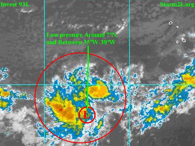
Looking farther east, Quickscat shows a well-defined low-level circulation center near 7N/34W this morning. Of course, the GFS is pretty clueless in that region, so it promptly loses it within 12-24hrs. Unfortunately, I can't get high-res visible images every 15-30 minutes today, as I'm out of state. So I can't examine it too well except with the free images online. I just e-mailed the office to create a series of satellite images (VIS/IR/WV) centered over that disturbance this morning. Hopefully, the person who needs to do this will see his e-mail soon.
0 likes   

chadtm80

#3 Postby chadtm80 » Sat Jun 28, 2003 9:12 am

Its official!! Invest 94L now up for carib system
0 likes   

chadtm80

#4 Postby chadtm80 » Sat Jun 28, 2003 9:29 am

93L invest new as well... Not to bad looking ATM http://www.nrlmry.navy.mil/tc-bin/tc_ho ... YLE=tables
0 likes   

User avatar
vbhoutex
Storm2k Executive
Storm2k Executive
Posts: 29112
Age: 73
Joined: Wed Oct 09, 2002 11:31 pm
Location: Cypress, TX
Contact:

#5 Postby vbhoutex » Sat Jun 28, 2003 9:30 am

chadtm80 wrote:Its official!! Invest 94L now up for carib system


Storm2k update is available in weather central. More to come at llam CDT update.
0 likes   
Skywarn, C.E.R.T.
Please click below to donate to STORM2K to help with the expenses of keeping the site going:
Image

chadtm80

#6 Postby chadtm80 » Sat Jun 28, 2003 9:32 am

93L info


000
WHXX01 KWBC 261236
CHGHUR

DISCLAIMER...NUMERICAL MODELS ARE SUBJECT TO LARGE ERRORS.
PLEASE REFER TO TPC/NHC OFFICIAL FORECASTS FOR TROPICAL CYCLONES.

.....THE FOLLOWING IS A TEST MESSAGE.....

NATIONAL HURRICANE CENTER NORTH ATLANTIC OBJECTIVE AIDS FOR

TROPICAL DEPRESSION INVEST (AL932003) ON 20030626 1200 UTC

...00 HRS... ...12 HRS... ...24 HRS... ...36 HRS...
030626 1200 030627 0000 030627 1200 030628 0000

LAT LON LAT LON LAT LON LAT LON
BAMD 8.5N 36.4W 9.0N 38.3W 9.4N 40.2W 9.6N 42.4W
BAMM 8.5N 36.4W 8.8N 38.2W 9.0N 40.2W 8.9N 42.4W
A98E 8.5N 36.4W 8.7N 38.4W 9.1N 40.6W 9.9N 43.0W
SHIP 25KTS 30KTS 35KTS 38KTS
DSHP 25KTS 30KTS 35KTS 38KTS

...48 HRS... ...72 HRS... ...96 HRS... ..120 HRS...
030628 1200 030629 1200 030630 1200 030701 1200

LAT LON LAT LON LAT LON LAT LON
BAMD 9.8N 44.8W 9.9N 49.9W 9.9N 54.3W 10.5N 56.9W
BAMM 8.8N 45.0W 8.5N 50.8W 8.6N 56.2W 9.5N 60.2W
A98E 10.7N 45.5W 12.2N 51.1W 13.2N 56.2W 13.7N 59.6W
SHIP 42KTS 45KTS 40KTS 37KTS
DSHP 42KTS 45KTS 40KTS 37KTS

...INITIAL CONDITIONS...
LATCUR = 8.5N LONCUR = 36.4W DIRCUR = 270DEG SPDCUR = 9KT
LATM12 = 8.4N LONM12 = 35.0W DIRM12 = 270DEG SPDM12 = 9KT
LATM24 = 8.5N LONM24 = 32.9W
WNDCUR = 25KT RMAXWD = 25NM WNDM12 = 20KT
CENPRS = 1009MB OUTPRS = 1012MB OUTRAD = 150NM SDEPTH = D
RD34NE = 0NM RD34SE = 0NM RD34SW = 0NM RD34NW = 0NM

.....THE ABOVE HAS BEEN A TEST MESSAGE.....

Image
0 likes   

Tip
Category 1
Category 1
Posts: 325
Joined: Fri May 30, 2003 7:31 am

AF MM5

#7 Postby Tip » Sat Jun 28, 2003 10:06 am

At the moment, the Air Force MM5 model is the only model to develop a true warm core system. The track is interesting with a Texas landfall at approx. 1000 mil. http://eyewall.met.psu.edu/cyclonephase ... 1.zoom.gif (time sensitive) :idea:
0 likes   

chadtm80

#8 Postby chadtm80 » Sat Jun 28, 2003 10:14 am

0 likes   

chadtm80

#9 Postby chadtm80 » Sat Jun 28, 2003 11:58 am

Updated 12:30 eastern
0 likes   

chadtm80

#10 Postby chadtm80 » Sat Jun 28, 2003 1:29 pm

28/18 WGMJ 25.3 -85.3 26.1 190 44 1014.3 -1.0 28.3 WGMJ
0 likes   

chadtm80

#11 Postby chadtm80 » Sat Jun 28, 2003 5:07 pm

storm2k 5pm is out, and it includes a discussion on 93L


Image
0 likes   


Return to “Talkin' Tropics”

Who is online

Users browsing this forum: Google Adsense [Bot], RomP, Stormybajan and 50 guests