#14 Postby GalvestonDuck » Tue Jul 15, 2003 9:20 am
Here's what I was referring to above, from the UTMB website:
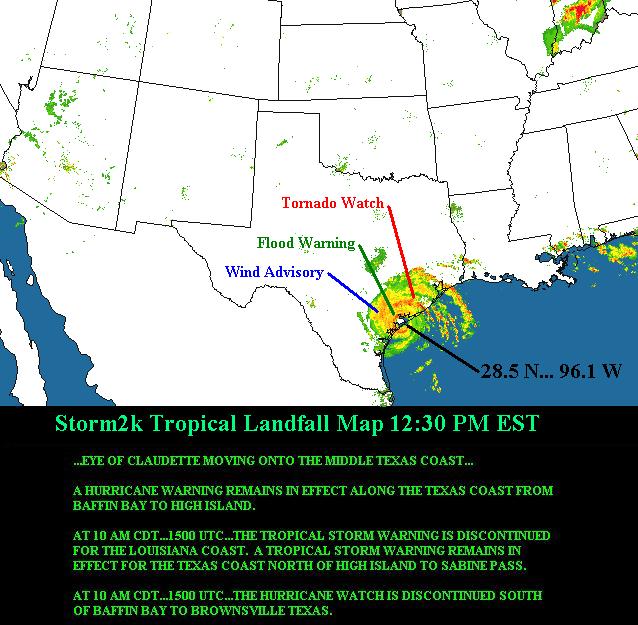
Claudette just off the Texas coast; landfall expected within hours
(posted 8:45 a.m.)
The center of Claudette is about 35 miles east of the barrier island on the outside of Matagorda Bay. Movement is to the west-northwest at about 15 mph. At this faster speed, the center of Claudette will move ashore into Matagorda Bay in less than 3 hours. The center of Claudette should track across central to northeastern Matagorda Bay then westward to just north of Victoria by early this afternoon. Claudette will be weakening quickly by this afternoon as the center moves farther inland. By late this afternoon, Claudette will be well inland and weakening to very minimal tropical storm strength if not a depression.
The Galveston area is likely to experience severe rainfall, possibly severe thunderstorms and sustained 25 mph winds over the next few hours. Tides in the Galveston area are running about 4-6 feet above normal. These tides will be diminishing gradually by early this afternoon.
As UTMB continues to monitor Claudette's progress, its hospitals, clinics, schools and offices are expected to be open as normal. Employees should continue to pay close attention to the progress of this storm. Those with homes in evacuation areas should discuss their options with supervisors. Remember: it is not safe to drive across roadways covered by water. Although Seawall Boulevard is usually the best route to campus, this morning employees should use Broadway as a route to work if possible. Please contact your supervisor as soon as possible if you anticipate or experience a problem arriving at work.
0 likes