Invest 98L South of Azores,Models,Sat Pics,And Discussions

This is the general tropical discussion area. Anyone can take their shot at predicting a storms path.

Moderator: S2k Moderators

Forum rules

The posts in this forum are NOT official forecasts and should not be used as such. They are just the opinion of the poster and may or may not be backed by sound meteorological data. They are NOT endorsed by any professional institution or STORM2K. For official information, please refer to products from the National Hurricane Center and National Weather Service.

Help Support Storm2K
Message
Author
User avatar
HURAKAN
Professional-Met
Professional-Met
Posts: 46086
Age: 38
Joined: Thu May 20, 2004 4:34 pm
Location: Key West, FL
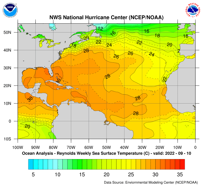
Contact:

Invest 98L South of Azores,Models,Sat Pics,And Discussions

#1 Postby HURAKAN » Mon Oct 02, 2006 2:46 pm

Image

http://weather.msfc.nasa.gov/GOES/goeseastfull.html

The system is still non-tropical but its making progress and maybe in the next 24 to 48 hours we could have some kind of tropical or subtropical depression or storm. Joyce could be around the corner. The 530 PM EDT TWO could be interesting.
0 likes   

CrazyC83
Professional-Met
Professional-Met
Posts: 34085
Joined: Tue Mar 07, 2006 11:57 pm
Location: Deep South, for the first time!

#2 Postby CrazyC83 » Mon Oct 02, 2006 3:46 pm

Azores? Well to the southeast, in Vince country. Nonetheless, I like the looks of it...could become Joyce this week.

I'd be declaring 98L on that one now.
0 likes   

User avatar
Buck
S2K Supporter
S2K Supporter
Posts: 1174
Joined: Fri Sep 10, 2004 12:04 pm
Location: Atlanta, GA

#3 Postby Buck » Mon Oct 02, 2006 3:59 pm

Yeah, this might should already be an Invest.
0 likes   

User avatar
HURAKAN
Professional-Met
Professional-Met
Posts: 46086
Age: 38
Joined: Thu May 20, 2004 4:34 pm
Location: Key West, FL
Contact:

#4 Postby HURAKAN » Mon Oct 02, 2006 4:00 pm

I know it's not exactly at the Azores but I just tried to give a well-known geographical place for reference.
0 likes   

User avatar
P.K.
Professional-Met
Professional-Met
Posts: 5149
Joined: Thu Sep 23, 2004 5:57 pm
Location: Watford, England
Contact:

#5 Postby P.K. » Mon Oct 02, 2006 4:22 pm

The analysis from last night at 0000 GMT showed this.

Weather bulletin for METAREA 2, METEO-FRANCE,
Toulouse, Monday 2 October 2006 at 09 UTC.

- Wind speed in BEAUFORT SCALE - Sea : Total significant -
- Please be aware, wind gusts can be a further 40 percent stronger
than the averages given here, and maximum waves may be up to twice
the significant height.

Part 1 : WARNING : 444.

Part 2 : General synopsis, Monday 2 at 00 UTC

Thundery low 1008 34N25W, moving southwest, expected 1010 30N30W by
03/12UTC.

Low 994 over north of England, moving northeast, expected over
Norway by 03/00UTC.
Secondary low deepening in trough, expected 1006 just southwest of
cape Finisterre by 02/12UTC, moving northeast, expected 1003 over
east of bay of Biscay by 03/00UTC.
High 1031 42N43W, slowly drifting east and weakening, expected 1026
40N36W by 03/12UTC.
Associated ridge building in east with high expected 1025 38N19W by
03/12UTC.


Low 1010 09N31W moving west 15/20 kt.
ITCZ along 11N13W 9N23W 8N35W 10N46W.


However I don't see it in the 1200 GMT analysis (It is a 1010hPa low in the NOAA charts at the same time).

Weather bulletin for METAREA 2, METEO-FRANCE
Toulouse, Monday 2 October 2006 at 21 UTC.

- Wind speed in BEAUFORT SCALE - Sea : Total significant -
- Please be aware, wind gusts can be a further 40 percent stronger
than the averages given here, and maximum waves may be up to twice
the significant height.

Part 1 : WARNING : nr 446.

Part 2 : General synopsis, Monday 2 at 12 UTC

Low 993 over North Sea, moving northeast, expected over Norway by
03/00UTC.
Associated trough extended to southwest with secondary thundery low
1005 just southwest of cape Finisterre. This secondary low moving
northeast and deepening, expected 998 over southeast of Bay of
Biscay by 03/06UTC.
New low " ex ISAAC " expected 994 51N49W by 04/00 UTC. Associated
disturbance reaching west of FARADAY by 04/00 UTC.
High 1031 41N41W moving southeastward, expected 1026 38N18W by
04/00 UTC.

Low 1010 09N32W moving west 10/15 kt.
ITCZ along 12N15W 10N28W 8N37W.


The KNMI international satrep from 1800 GMT shows an ULL at 30N 28W.
0 likes   

User avatar
Thunder44
Category 5
Category 5
Posts: 5922
Age: 44
Joined: Mon Jun 09, 2003 7:53 pm
Location: New York City

#6 Postby Thunder44 » Mon Oct 02, 2006 4:33 pm

486
ABNT20 KNHC 022130
TWOAT
TROPICAL WEATHER OUTLOOK
NWS TPC/NATIONAL HURRICANE CENTER MIAMI FL
530 PM EDT MON OCT 2 2006

FOR THE NORTH ATLANTIC...CARIBBEAN SEA AND THE GULF OF MEXICO...

THE NATIONAL HURRICANE CENTER HAS ISSUED ITS LAST ADVISORY ON
ISAAC...WHICH IS LOSING TROPICAL CHARACTERISTICS ABOUT 50 MILES
EAST-NORTHEAST OF CAPE RACE NEWFOUNDLAND.

SHOWER ACTIVITY ASSOCIATED WITH A BROAD LOW PRESSURE SYSTEM LOCATED
ABOUT 725 MILES SOUTHWEST OF THE CAPE VERDE ISLANDS REMAINS
MINIMAL. UPPER LEVEL WINDS ARE NOT CONDUCIVE FOR DEVELOPMENT OF
THIS SYSTEM AS IT MOVES SLOWLY WEST-NORTHWESTWARD.

A NON-TROPICAL AREA OF LOW PRESSURE HAS DEVELOPED IN THE FAR EASTERN
ATLANTIC ABOUT 550 MILES SOUTH OF THE AZORES ISLANDS. THIS SYSTEM
COULD SLOWLY ACQUIRE SOME TROPICAL CHARACTERISTICS DURING THE NEXT
DAY OR TWO AS IT MOVES VERY LITTLE.


ELSEWHERE...TROPICAL STORM FORMATION IS NOT EXPECTED THROUGH
TUESDAY.

$$
FORECASTER KNABB
Last edited by Thunder44 on Mon Oct 02, 2006 4:34 pm, edited 1 time in total.
0 likes   

User avatar
wxman57
Moderator-Pro Met
Moderator-Pro Met
Posts: 23010
Age: 67
Joined: Sat Jun 21, 2003 8:06 pm
Location: Houston, TX (southwest)

#7 Postby wxman57 » Mon Oct 02, 2006 4:36 pm

SSTs in the area are 26-27C. The pattern is similar to the one that spawned several late-season storms in 2005 there. Could well become Joyce in a day or two. Only a threat to the Azorians (is that what they're called?).
0 likes   

User avatar
cycloneye
Admin
Admin
Posts: 146115
Age: 69
Joined: Thu Oct 10, 2002 10:54 am
Location: San Juan, Puerto Rico

#8 Postby cycloneye » Mon Oct 02, 2006 4:48 pm

It's a matter of time that they will start to have model runs for this system,maybe tonight or tommorow morning,and when that occurs invest 98L will be up.
0 likes   

User avatar
Yarrah
Category 2
Category 2
Posts: 658
Joined: Tue Feb 07, 2006 6:15 pm
Location: Utrecht, The Netherlands
Contact:

#9 Postby Yarrah » Mon Oct 02, 2006 5:05 pm

KNMI doesn't expect the low to develop into something (sub)tropical but expects it to weaken. Take a look at the following maps: http://www.knmi.nl/waarschuwingen_en_ve ... aarten.php
0 likes   

User avatar
cycloneye
Admin
Admin
Posts: 146115
Age: 69
Joined: Thu Oct 10, 2002 10:54 am
Location: San Juan, Puerto Rico

#10 Postby cycloneye » Mon Oct 02, 2006 5:10 pm

http://tcweb.fnmoc.navy.mil/tc-bin/tc_home.cgi

Well as I said above,as soon the first run of the models is runned we will see invest 98L and here it is!!!.
0 likes   
Visit the Caribbean-Central America Weather Thread where you can find at first post web cams,radars
and observations from Caribbean basin members Click Here

User avatar
P.K.
Professional-Met
Professional-Met
Posts: 5149
Joined: Thu Sep 23, 2004 5:57 pm
Location: Watford, England
Contact:

#11 Postby P.K. » Mon Oct 02, 2006 5:13 pm

2100 GMT air mass image from Meteosat 9

Image
0 likes   

User avatar
HURAKAN
Professional-Met
Professional-Met
Posts: 46086
Age: 38
Joined: Thu May 20, 2004 4:34 pm
Location: Key West, FL
Contact:

#12 Postby HURAKAN » Mon Oct 02, 2006 5:33 pm

Image
0 likes   

CrazyC83
Professional-Met
Professional-Met
Posts: 34085
Joined: Tue Mar 07, 2006 11:57 pm
Location: Deep South, for the first time!

#13 Postby CrazyC83 » Mon Oct 02, 2006 5:35 pm

No surprise. Vince 2.0, almost exactly a year later?
0 likes   

User avatar
hial2
S2K Supporter
S2K Supporter
Posts: 809
Joined: Fri Oct 10, 2003 9:20 pm
Location: Indian trail N.C.

#14 Postby hial2 » Mon Oct 02, 2006 5:38 pm

wxman57 wrote:SSTs in the area are 26-27C.


The Azores are a jump and a skip away from Iberia and the SSTs are that high so far north? Is that normal? And is it normal for TCs to form in the area? Thanks for the info..
0 likes   

User avatar
wxmann_91
Category 5
Category 5
Posts: 8013
Age: 34
Joined: Fri Jul 15, 2005 2:49 pm
Location: Southern California
Contact:

#15 Postby wxmann_91 » Mon Oct 02, 2006 5:46 pm

Good find. Kudos to the global models as they developed this feature on runs a few days ago.
0 likes   

User avatar
HURAKAN
Professional-Met
Professional-Met
Posts: 46086
Age: 38
Joined: Thu May 20, 2004 4:34 pm
Location: Key West, FL
Contact:

#16 Postby HURAKAN » Mon Oct 02, 2006 5:56 pm

hial2 wrote:
wxman57 wrote:SSTs in the area are 26-27C.


The Azores are a jump and a skip away from Iberia and the SSTs are that high so far north? Is that normal? And is it normal for TCs to form in the area? Thanks for the info..


They are between 24º - 26º C.

Image

By the way, NRL initialized at 29.6N & 29.8W @ 35 MPH, 1008 MB. This could very well become Joyce when it does the transition to subtropical or tropical. I will be interesting to see if the NHC is going to wait until it becomes tropical like the did with Otto or begin writing advisories when it starts showing subtropical caracteristics.
0 likes   

User avatar
cycloneye
Admin
Admin
Posts: 146115
Age: 69
Joined: Thu Oct 10, 2002 10:54 am
Location: San Juan, Puerto Rico

#17 Postby cycloneye » Mon Oct 02, 2006 7:42 pm

03/0000 UTC 29.6N 30.9W ST1.5/1.5 98L -- Atlantic Ocean

For those who may not know,that ST that you see beside the T numbers is for SubTropical.
0 likes   
Visit the Caribbean-Central America Weather Thread where you can find at first post web cams,radars
and observations from Caribbean basin members Click Here

User avatar
HURAKAN
Professional-Met
Professional-Met
Posts: 46086
Age: 38
Joined: Thu May 20, 2004 4:34 pm
Location: Key West, FL
Contact:

#18 Postby HURAKAN » Mon Oct 02, 2006 8:00 pm

Nice numbers already from Dvorak.
0 likes   

User avatar
HURAKAN
Professional-Met
Professional-Met
Posts: 46086
Age: 38
Joined: Thu May 20, 2004 4:34 pm
Location: Key West, FL
Contact:

#19 Postby HURAKAN » Mon Oct 02, 2006 8:04 pm

Image
0 likes   

CrazyC83
Professional-Met
Professional-Met
Posts: 34085
Joined: Tue Mar 07, 2006 11:57 pm
Location: Deep South, for the first time!

#20 Postby CrazyC83 » Mon Oct 02, 2006 8:24 pm

1008mb / 35kt it says up there.

That means if it closes up, it would immediately become (Sub)Tropical Storm Joyce.
0 likes   


Return to “Talkin' Tropics”

Who is online

Users browsing this forum: 869MB, Google Adsense [Bot], Ian2401, LAF92, Pelicane, skillz305, Stormi and 61 guests