Sorry if this is a no-brainer, but I have a question about storm surge.
Let's say a hurricane is making landfall on the east coast of Florida and moves across the state. Will the west coast experience a storm surge?
Question about storm surge
Moderator: S2k Moderators
Forum rules

The posts in this forum are NOT official forecasts and should not be used as such. They are just the opinion of the poster and may or may not be backed by sound meteorological data. They are NOT endorsed by any professional institution or STORM2K. For official information, please refer to products from the National Hurricane Center and National Weather Service.
-
HurricaneBill
- Category 5

- Posts: 3420
- Joined: Sun Apr 11, 2004 5:51 pm
- Location: East Longmeadow, MA, USA
Question about storm surge
0 likes


Re: Question about storm surge
I remember this happening with Frances/2004 in our area. She hit the east coast, crossed the state and exited on the west, the storm surge was south of the storm and it came up in the mouth of Tampa Bay, the storm surge and high tide combined flooded a large area of homes in Oldsmar.
0 likes
-
Derek Ortt
Re: Question about storm surge
I believe the surge in that scenario is only where the winds are onshore.
When the storm makes landfall, due to the wave action, you can have offshore winds, yet still have a significant tidal surge
When the storm makes landfall, due to the wave action, you can have offshore winds, yet still have a significant tidal surge
0 likes
-
wxman57

- Moderator-Pro Met

- Posts: 23130
- Age: 68
- Joined: Sat Jun 21, 2003 8:06 pm
- Location: Houston, TX (southwest)
Re: Question about storm surge
Correct answer here would be "no", the west coast of Florida would not experience any storm "surge". However, any moderate to strong onshore winds south of the center could cause tides to run above normal south of the track along the western peninsula as the hurricane/TS moves out into the eastern Gulf of Mexico.
0 likes
-
TheShrimper
- Category 2

- Posts: 516
- Joined: Sun Aug 01, 2004 5:05 pm
Re: Question about storm surge
I agree there would not be a surge, so to speak. That can only be arrived at in a westerly moving storm to the north of the center and south of the center on a storm heading to the east, or some componant of east. A question can arise however as to this claim, if a hurricane was parreleling the the Fla. Keys from Key West to Key Largo. Granted there would be tremendous surge ahead of the NE trek, but also behind the center driven by North or Northwesterly winds. That said, the correct way to phrase the original question would have been on the lines of " would there be rising water complications anywhere on the west coast of Fl. if a hurricane were to traverse the state. " Surge" is a loosely defined entity, and can be interputed many different ways. Disregard statements thrown around as "negative storm surge". It's an oxymoron.
0 likes

Re: Question about storm surge
Hi All - There appears to be some confusion with this topic, perhaps related to the nomenclature of "storm surge" vs "storm tide"... but you ABSOLUTELY can have a storm surge (and a significant one at that) when a tropical cyclone exits a landmass back into a body of water.
Using a SE Florida landfall, from a westward moving storm, as an example... even at the time of the initial landfall, you will have storm surge from onshore winds to the north of the center... and storm surge to the south of the center, on any barrier islands, as water from the bay is forced east with winds that are "offshore" to the mainland... but "onshore" for the barrier islands.
As the storm moves across the peninsula... from the point where it exits the coast back into the Gulf of Mexico, and south, storm surge would be experienced. In most cases the surge would not be as large as during the initial landfall (as the storm would likely be weaker and wouldn't have been piling up water against the shore for as long a duration), however, two major factors in the resulting height of the surge are the bathymetry/geography of the coastal area... and the astronomical tidal height. If the coastal area where the storm exits happens to have very shallow water, and the storm exits near the time of high tide, the resulting surge can be even greater than during the initial landfall.
Such was the case with Katrina's first landfall in South Florida... the highest storm surge values were observed over the Cape Sable area of the extreme SW Florida coast, to the south of the point where Katrina exited the peninsula. (See the image below)

Here's a link to a PDF of the NHC/TPC's Tropical Cyclone Report on Katrina... the section covering the storm surge over Southwest Florida is located on page 10.
http://www.nhc.noaa.gov/pdf/TCR-AL122005_Katrina.pdf
As for the nomenclature, the correct definitions of "Storm Surge" and "Storm Tide", from the NHC/TPC Glossary are:
Storm Surge
An abnormal rise in sea level accompanying a hurricane or other intense storm, and whose height is the difference between the observed level of the sea surface and the level that would have occurred in the absence of the cyclone. Storm surge is usually estimated by subtracting the normal or astronomic high tide from the observed storm tide.
Storm Tide
The actual level of sea water resulting from the astronomic tide combined with the storm surge.
-=Michael=-
http://www.tropmet.com
Using a SE Florida landfall, from a westward moving storm, as an example... even at the time of the initial landfall, you will have storm surge from onshore winds to the north of the center... and storm surge to the south of the center, on any barrier islands, as water from the bay is forced east with winds that are "offshore" to the mainland... but "onshore" for the barrier islands.
As the storm moves across the peninsula... from the point where it exits the coast back into the Gulf of Mexico, and south, storm surge would be experienced. In most cases the surge would not be as large as during the initial landfall (as the storm would likely be weaker and wouldn't have been piling up water against the shore for as long a duration), however, two major factors in the resulting height of the surge are the bathymetry/geography of the coastal area... and the astronomical tidal height. If the coastal area where the storm exits happens to have very shallow water, and the storm exits near the time of high tide, the resulting surge can be even greater than during the initial landfall.
Such was the case with Katrina's first landfall in South Florida... the highest storm surge values were observed over the Cape Sable area of the extreme SW Florida coast, to the south of the point where Katrina exited the peninsula. (See the image below)
Here's a link to a PDF of the NHC/TPC's Tropical Cyclone Report on Katrina... the section covering the storm surge over Southwest Florida is located on page 10.
http://www.nhc.noaa.gov/pdf/TCR-AL122005_Katrina.pdf
As for the nomenclature, the correct definitions of "Storm Surge" and "Storm Tide", from the NHC/TPC Glossary are:
Storm Surge
An abnormal rise in sea level accompanying a hurricane or other intense storm, and whose height is the difference between the observed level of the sea surface and the level that would have occurred in the absence of the cyclone. Storm surge is usually estimated by subtracting the normal or astronomic high tide from the observed storm tide.
Storm Tide
The actual level of sea water resulting from the astronomic tide combined with the storm surge.
-=Michael=-
http://www.tropmet.com
Last edited by vmax135 on Thu Jun 21, 2007 7:40 pm, edited 1 time in total.
0 likes
-
TheShrimper
- Category 2
- Posts: 516
- Joined: Sun Aug 01, 2004 5:05 pm
Re:
TheShrimper wrote:So when you could walk across Charlotte Harbor in 1960 when Donna impacted south Lee County, what is that phenomenon in meteorological terms refered to?
Hi Shrimper - If your question is specifically about what the meteorological term is when all the water is pushed out of a bay, inlet, estuary, etc... from strong winds, I'm not sure there is a formal meteorological one. There might be an oceanographic term, perhaps "drainage"? Maybe someone with more oceanographic experience can chime in?
I experienced a similar scenario during my Hurricane Emily chase in 1993. I was on the west side of Pamlico Sound in North Carolina and all the water completely disappeared, as it was driven southeast, producing a major storm surge over Hatteras Island, inundating places like Rodanthe, Avon and Buxton... with a complete overwash of the island in many places.
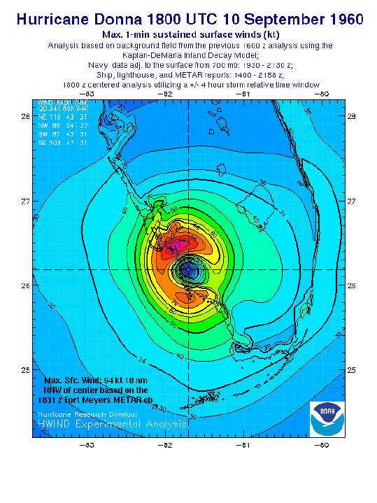
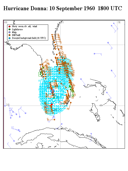
In any event, in the specific case of Donna, when the strong northeasterly winds began impacting the Charlotte Harbor area, as the core of the hurricane approached from Lee county, the shallow water of the harbor was driven southwest, producing a storm surge along east-facing coastal areas on the west & southwest side of the estuary... inundating areas around Gasparilla Sound, Boca Grande, Pine Island, etc... As the storm moved to the north, the winds shifted from northeast to north and eventually to the west allowing the water to fill back into the harbor.
Here's a surface wind-analysis of Donna near the time it was exiting Collier county and entering Lee county... about the time the drainage of Charlotte Harbor would have begun
-=Michael=-
http://www.tropmet.com
Last edited by vmax135 on Fri Jun 22, 2007 5:40 pm, edited 1 time in total.
0 likes
-
wxman57
- Moderator-Pro Met
- Posts: 23130
- Age: 68
- Joined: Sat Jun 21, 2003 8:06 pm
- Location: Houston, TX (southwest)
Re: Question about storm surge
I would argue that this was more a case of a setup tide than a true storm surge. Any time the wind blows toward the coast it'll tend to raise tides along that coast. This is what happens when a hurricane/tropical storm moves from east to west across the FL peninsula. Once the storm moves out into the Gulf, there's a long fetch of SW-WSW winds blowing toward the peninsula that raise tides above normal. Katrina was a good example of that. There was no significant surge on the east side of Florida because max winds were south of the center blowing from the southwest offshore. Once Katrina moved across the peninsula, the winds were blowing onshore, creating tides 3-5 feet above normal.
So, more precisely, we could say that there is no storm surge from a hurricane moving offshore, but that doesn't mean that tides can't increase significantly once the storm passes and you're in strong onshore winds.
So, more precisely, we could say that there is no storm surge from a hurricane moving offshore, but that doesn't mean that tides can't increase significantly once the storm passes and you're in strong onshore winds.
vmax135 wrote:Hi All - There appears to be some confusion with this topic, perhaps related to the nomenclature of "storm surge" vs "storm tide"... but you ABSOLUTELY can have a storm surge (and a significant one at that) when a tropical cyclone exits a landmass back into a body of water.
Using a SE Florida landfall, from a westward moving storm, as an example... even at the time of the initial landfall, you will have storm surge from onshore winds to the north of the center... and storm surge to the south of the center, on any barrier islands, as water from the bay is forced east with winds that are "offshore" to the mainland... but "onshore" for the barrier islands.
As the storm moves across the peninsula... from the point where it exits the coast back into the Gulf of Mexico, and south, storm surge would be experienced. In most cases the surge would not be as large as during the initial landfall (as the storm would likely be weaker and wouldn't have been piling up water against the shore for as long a duration), however, two major factors in the resulting height of the surge are the bathymetry/geography of the coastal area... and the tidal height. If the coastal area where the storm exits happens to have very shallow water, and the storm exits near the time of high tide, the resulting surge can be even greater than during the initial landfall.
Such was the case with Katrina's first landfall in South Florida... the highest storm surge values were observed over the Cape Sable area of the extreme SW Florida coast, to the south of the point where Katrina exited the peninsula. (See the image below)
http://www.srh.noaa.gov/mfl/events/katrina/surge.jpg" target="_blank
Here's a link to a PDF of the NHC/TPC's Tropical Cyclone Report on Katrina... the section covering the storm surge over Southwest Florida is located on page 10.
http://www.nhc.noaa.gov/pdf/TCR-AL122005_Katrina.pdf
As for the nomenclature, the correct definitions of "Storm Surge" and "Storm Tide", from the NHC/TPC Glossary are:
Storm Surge
An abnormal rise in sea level accompanying a hurricane or other intense storm, and whose height is the difference between the observed level of the sea surface and the level that would have occurred in the absence of the cyclone. Storm surge is usually estimated by subtracting the normal or astronomic high tide from the observed storm tide.
Storm Tide
The actual level of sea water resulting from the astronomic tide combined with the storm surge.
0 likes
-
wobblehead
- Tropical Storm

- Posts: 133
- Joined: Fri Jul 15, 2005 12:51 pm
- Location: Mobile.Al
As for the nomenclature, the correct definitions of "Storm Surge" and "Storm Tide", from the NHC/TPC Glossary are:
Storm Surge
An abnormal rise in sea level accompanying a hurricane or other intense storm, and whose height is the difference between the observed level of the sea surface and the level that would have occurred in the absence of the cyclone. Storm surge is usually estimated by subtracting the normal or astronomic high tide from the observed storm tide.
Using this definition a coastline would experience storm surge long before the storm hit. I thought storm surge is the uplifted dome of water developed by the low atmospheric pressure within the eye plus the waves stacked on top of it.
0 likes
Re: Question about storm surge
Sorry wxman57, I have to disagree... but again, I think what is in question might be more the definition of "storm surge" vs. what you describe as a "setup tide".wxman57 wrote:I would argue that this was more a case of a setup tide than a true storm surge. Any time the wind blows toward the coast it'll tend to raise tides along that coast. This is what happens when a hurricane/tropical storm moves from east to west across the FL peninsula. Once the storm moves out into the Gulf, there's a long fetch of SW-WSW winds blowing toward the peninsula that raise tides above normal. Katrina was a good example of that. There was no significant surge on the east side of Florida because max winds were south of the center blowing from the southwest offshore. Once Katrina moved across the peninsula, the winds were blowing onshore, creating tides 3-5 feet above normal.
So, more precisely, we could say that there is no storm surge from a hurricane moving offshore, but that doesn't mean that tides can't increase significantly once the storm passes and you're in strong onshore winds.
In any instance where strong winds within a tropical cyclone are forcing water onshore (from virtually any type of oceanographic body... ocean, bay, estuary, lake, etc...), the result is known as "storm surge". The use of that term is agnostic of where the storm is at any given point... offshore, making landfall, overland, exiting a landmass, etc...
This nomenclature is always used, even in public advisories from the NHC/TPC, when describing exiting storms... again, using Katrina's South Florida landfall as an example, here is an excerpt from NHC's Public Advisory #10 at 11pm ET on August 25, 2005... when Katrina was inland over western Miami-Dade county...
AT 11 PM EDT...0300Z...THE EYE OF HURRICANE KATRINA WAS LOCATED NEAR
LATITUDE 25.5 NORTH...LONGITUDE 80.7 WEST OR ABOUT 35 MILES...
SOUTHWEST OF MIAMI FLORIDA OR 20 MILES NORTHWEST OF THE CITY OF
HOMESTEAD.
KATRINA IS MOVING TOWARD THE SOUTHWEST NEAR 8 MPH AND THIS MOTION IS
EXPECTED TO CONTINUE DURING THE NEXT SEVERAL HOURS. KATRINA IS
EXPECTED TO MOVE OVER THE GULF OF MEXICO FRIDAY MORNING.
MAXIMUM SUSTAINED WINDS ARE NEAR 75 MPH WITH HIGHER GUSTS. KATRINA
IS A CATEGORY ONE HURRICANE ON THE SAFFIR-SIMPSON SCALE. SOME
ADDITIONAL WEAKENING IS ANTICIPATED WHILE KATRINA IS OVER LAND.
HURRICANE FORCE WINDS EXTEND OUTWARD UP TO 10 MILES FROM THE
CENTER...AND TROPICAL STORM FORCE WINDS EXTEND OUTWARD UP
TO 70 MILES. EARLIER THIS EVENING A WIND GUST TO 87 MPH WAS RECORDED
AT MIAMI NATIONAL WEATHER SERVICE FORECAST OFFICE/NATIONAL
HURRICANE CENTER AND 81 MPH AT THE TAMIAMI AIRPORT.
ESTIMATED MINIMUM CENTRAL PRESSURE IS 984 MB...29.06 INCHES.
STORM SURGE FLOODING OF 2 TO 4 FEET ABOVE NORMAL TIDE LEVELS...
CAN BE EXPECTED ALONG THE WEST COAST OF FLORIDA IN AREAS OF ONSHORE
FLOW SOUTH OF VENICE AND IN FLORIDA BAY. STORM SURGE SHOULD BEGIN
TO DECREASE ALONG THE EAST COAST OF FLORIDA.
-=Michael=-
http://www.tropmet.com
Last edited by vmax135 on Thu Jun 21, 2007 10:44 pm, edited 2 times in total.
0 likes
Re:
Hi Wobble - Actually you're assumption is correct... "Storm Surge" setup can begin LONG before the storm actually hits. Water levels may begin to rise noticably from water being piled against the shore, while the skies are still blue and winds are light. In Mississippi in 1985, my chase team documented the water level having already risen to cover all of the docks at the Biloxi Port Authority on the morning of August 30th, even though Hurricane Elena was over 200 miles to the southeast. The water was completely still BTW, and the sky was clear blue, except for the advancing Cirrus shield to the south over the Gulf.wobblehead wrote:As for the nomenclature, the correct definitions of "Storm Surge" and "Storm Tide", from the NHC/TPC Glossary are:
Storm Surge
An abnormal rise in sea level accompanying a hurricane or other intense storm, and whose height is the difference between the observed level of the sea surface and the level that would have occurred in the absence of the cyclone. Storm surge is usually estimated by subtracting the normal or astronomic high tide from the observed storm tide.
Using this definition a coastline would experience storm surge long before the storm hit. I thought storm surge is the uplifted dome of water developed by the low atmospheric pressure within the eye plus the waves stacked on top of it.
Your question about the "dome" of water is a good one... in years past that was widely used to describe a "storm surge"... even Neil Frank (ex-Director of the NHC) was very fond of describing it that way... but it is now known that the rise in water-level associated with a storm surge is primarily (more than 80%) the result of the onshore winds forcing water into and over coastal areas... and that the rise in water level associated with the very low atmospheric pressure at the center of the storm, is really only responsible for less than 20% of overall surge height. Here's another good description from Dr. Chris Landsea on the subject from the online Hurricane FAQ from the NHC/AOML:
Subject : C1) Doesn't the low pressure in the tropical cyclone center cause the storm surge? Contributed by Chris Landsea
No. Many people assume that the partial vacuum at the center of a tropical cyclone allows the ocean to rise up in response, thus causing the destructive storm surges as the cyclone makes landfall. However, this effect would be, for example, with a 900 mb central pressure tropical cyclone, only 1 m (3 ft). The total storm surge for a tropical cyclone of this intensity can be from 6 to 10 m (19 to 33 ft), or more. Most (>85%) of the storm surge is caused by winds pushing the ocean surface ahead of the storm on the right side of the track (left side of the track in the Southern Hemisphere).

Since the surface pressure gradient (from the tropical cyclone center to the environmental conditions) determines the wind strength, the central pressure indirectly does indicate the height of the storm surge, but not directly. Note also that individual storm surges are dependent upon the coastal topography, angle of incidence of landfall, speed of tropical cyclone motion as well as the wind strength.
Here's a link to the FAQ...
http://www.aoml.noaa.gov/hrd/tcfaq/tcfaqHED.html
-=Michael=-
http://www.tropmet.com
Last edited by vmax135 on Thu Jun 21, 2007 10:18 pm, edited 1 time in total.
0 likes
-
wobblehead
- Tropical Storm
- Posts: 133
- Joined: Fri Jul 15, 2005 12:51 pm
- Location: Mobile.Al
Who is online
Users browsing this forum: No registered users and 44 guests