The MJO come July ....increased activity??

This is the general tropical discussion area. Anyone can take their shot at predicting a storms path.

Moderator: S2k Moderators

Forum rules

The posts in this forum are NOT official forecasts and should not be used as such. They are just the opinion of the poster and may or may not be backed by sound meteorological data. They are NOT endorsed by any professional institution or STORM2K. For official information, please refer to products from the National Hurricane Center and National Weather Service.

Help Support Storm2K
Message
Author
Aric Dunn
Category 5
Category 5
Posts: 21238
Age: 42
Joined: Sun Sep 19, 2004 9:58 pm
Location: Ready for the Chase.
Contact:

The MJO come July ....increased activity??

#1 Postby Aric Dunn » Mon Jun 25, 2007 1:52 pm

The MJO forecast for the july verse june. july may turn out to be a busy month..

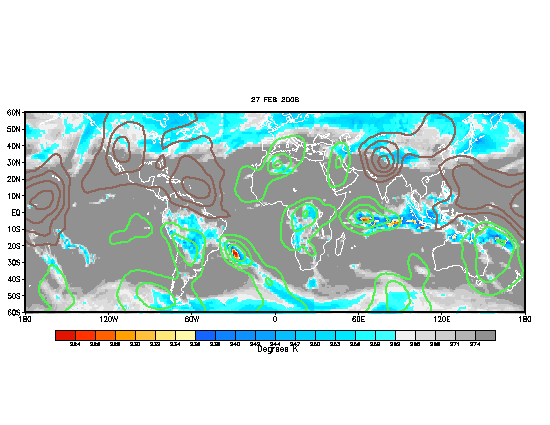
first off the MJO is not the only factor that would suggest any increase in activity it is just one tool used, and in the past has shown some level of accuracy in predicting at a minimum and increase in over cloud cover or convection and the image below is just that. The OLR is for the most part the same has the MJO its just another way of saying the same thing. The OLR is the amount of cloud cover or convection so when the OLR is very negative then then MJO is very positive if you where to compare the MJO with the OLR you would see that they are the same, take for instance now, the MJO is negative and the OLR is positive(which is typically not as good for development). in other words july may turn out to be a rather busy month verses june which was forecast to be drier than average (which did happen) and july which is now forecast to be wetter than average hence a possible increase in activity come the first week of july.
ImageImage
Last edited by Aric Dunn on Mon Jun 25, 2007 2:15 pm, edited 2 times in total.
0 likes   

Aric Dunn
Category 5
Category 5
Posts: 21238
Age: 42
Joined: Sun Sep 19, 2004 9:58 pm
Location: Ready for the Chase.
Contact:

Re: The MJO come July

#2 Postby Aric Dunn » Mon Jun 25, 2007 2:01 pm

and here is the current MJO notice its positiveImage
0 likes   

Aric Dunn
Category 5
Category 5
Posts: 21238
Age: 42
Joined: Sun Sep 19, 2004 9:58 pm
Location: Ready for the Chase.
Contact:

#3 Postby Aric Dunn » Mon Jun 25, 2007 3:54 pm

well i guess no one knows what it is or just dont care :(
0 likes   

hcane
Tropical Low
Tropical Low
Posts: 41
Joined: Tue Apr 29, 2003 8:32 pm

Re: The MJO come July ....increased activity??

#4 Postby hcane » Mon Jun 25, 2007 3:57 pm

May be that there are most who don't understand the significance of the MJO to cyclone development.
0 likes   

User avatar
Aquawind
Category 5
Category 5
Posts: 6714
Age: 62
Joined: Mon Jun 16, 2003 10:41 pm
Location: Salisbury, NC
Contact:

#5 Postby Aquawind » Mon Jun 25, 2007 3:57 pm

LOL.. don't take is so hard dude. 8-) MJO has been very bad in recent years. But yeah it could be part of the equation to this above average season predicted..
0 likes   

Aric Dunn
Category 5
Category 5
Posts: 21238
Age: 42
Joined: Sun Sep 19, 2004 9:58 pm
Location: Ready for the Chase.
Contact:

Re:

#6 Postby Aric Dunn » Mon Jun 25, 2007 4:03 pm

Aquawind wrote:LOL.. don't take is so hard dude. 8-) MJO has been very bad in recent years. But yeah it could be part of the equation to this above average season predicted..


thats the thing though .... it does not predict increased activity as with TC.. thats the big misconception .. it is simply tells us that there will be an increased likely hood of cloudiness or more convection . and that is important .. becuase it tells us that we are going to be heading towards a more favorable environment or deeper convection( not necessarily better shear) which is needed for tc development. thats why its significant .. not because its a genesis predictor. i pay more attention to the likely hood of organized convection during times of positive MJO because its a good indicator.
0 likes   

TheRingo
Tropical Storm
Tropical Storm
Posts: 170
Joined: Sat Aug 26, 2006 4:46 pm

#7 Postby TheRingo » Mon Jun 25, 2007 4:11 pm

it definitely aided in the indian ocean developments. Both storms developed when mjo was in that region. Also Berry developed when mjo was in this region.
0 likes   

Aric Dunn
Category 5
Category 5
Posts: 21238
Age: 42
Joined: Sun Sep 19, 2004 9:58 pm
Location: Ready for the Chase.
Contact:

Re:

#8 Postby Aric Dunn » Mon Jun 25, 2007 4:15 pm

TheRingo wrote:it definitely aided in the indian ocean developments. Both storms developed when mjo was in that region. Also Berry developed when mjo was in this region.


yep barry formed at the end of the last positive MJO cycle


Image

june first !! image

the green colors mean positive(good) and the brown(bad) means negative..
Last edited by Aric Dunn on Mon Jun 25, 2007 4:16 pm, edited 2 times in total.
0 likes   

User avatar
Aquawind
Category 5
Category 5
Posts: 6714
Age: 62
Joined: Mon Jun 16, 2003 10:41 pm
Location: Salisbury, NC
Contact:

#9 Postby Aquawind » Mon Jun 25, 2007 4:15 pm

Those maps have been highly suspect at times. Right though when were in the wet phase it might reflect in some activity but certainly we get systems in the dry phase as well. Wet MJO during prime time should be busy but we know ther is alot more to the story and it may mean nothing..
0 likes   

Aric Dunn
Category 5
Category 5
Posts: 21238
Age: 42
Joined: Sun Sep 19, 2004 9:58 pm
Location: Ready for the Chase.
Contact:

Re:

#10 Postby Aric Dunn » Mon Jun 25, 2007 4:20 pm

Aquawind wrote:Those maps have been highly suspect at times. Right though when were in the wet phase it might reflect in some activity but certainly we get systems in the dry phase as well. Wet MJO during prime time should be busy but we know ther is alot more to the story and it may mean nothing..


yeah maps are always going to suspect lol but what can you do! :) yeah a wet MJo or positive MJO is normally a better chance because of the better chances for precip..

think of the MJO as a tropical wave .. normally with a tropical wave there is more convection because there is some lifting .. so the MJO is similar but really high up and moves from west to east instead of east to west.
0 likes   

User avatar
Aquawind
Category 5
Category 5
Posts: 6714
Age: 62
Joined: Mon Jun 16, 2003 10:41 pm
Location: Salisbury, NC
Contact:

#11 Postby Aquawind » Mon Jun 25, 2007 4:24 pm

Yeah if I wanna check it out this link had a great Power Point Presentation on the current status plus an Adobe pdf file with the mjo overview.

http://www.cpc.ncep.noaa.gov/products/p ... /mjo.shtml
0 likes   

Aric Dunn
Category 5
Category 5
Posts: 21238
Age: 42
Joined: Sun Sep 19, 2004 9:58 pm
Location: Ready for the Chase.
Contact:

Re:

#12 Postby Aric Dunn » Mon Jun 25, 2007 4:27 pm

Aquawind wrote:Yeah if I wanna check it out this link had a great Power Point Presentation on the current status plus an Adobe pdf file with the mjo overview.

http://www.cpc.ncep.noaa.gov/products/p ... /mjo.shtml" target="_blank


yeah great site.. i use it all the time
0 likes   

User avatar
Aquawind
Category 5
Category 5
Posts: 6714
Age: 62
Joined: Mon Jun 16, 2003 10:41 pm
Location: Salisbury, NC
Contact:

Re: The MJO come July ....increased activity??

#13 Postby Aquawind » Mon Jun 25, 2007 4:47 pm

Actually the latest update on that website just came out today. Either in PPT of PDF format. Very interesting to see the progress of the Weekly heat content evolution anomilies in the Pacific..big warm jump eastward to 130W..
0 likes   

User avatar
Nimbus
Category 5
Category 5
Posts: 5329
Joined: Mon Jul 19, 2004 10:54 am

Re: The MJO come July ....increased activity??

#14 Postby Nimbus » Mon Jun 25, 2007 5:20 pm

If the MJO forecast is correct we should see an end to the SAL and dry air that has been hindering development in the Atlantic.

It is interesting to see the heat content slowly creeping north as the sun track approaches the tropic of cancer. You would expect more convection over the warmer ocean areas.

The Pacific anomoly east of Hawaii appears to be neutral maybe cooling slightly but that may not have much of an effect on shear in the Atlantic.

I'm curious how long that forecast large mid atlantic ridge will stay in place. That is the number 1 feature that could make or break the forecast for an active season. If a huge mid atlantic ridge is going to be the dominant pattern this summer it could be an active season indeed.
0 likes   

Aric Dunn
Category 5
Category 5
Posts: 21238
Age: 42
Joined: Sun Sep 19, 2004 9:58 pm
Location: Ready for the Chase.
Contact:

Re: The MJO come July ....increased activity??

#15 Postby Aric Dunn » Mon Jun 25, 2007 7:42 pm

Nimbus wrote:If the MJO forecast is correct we should see an end to the SAL and dry air that has been hindering development in the Atlantic.

It is interesting to see the heat content slowly creeping north as the sun track approaches the tropic of cancer. You would expect more convection over the warmer ocean areas.

The Pacific anomoly east of Hawaii appears to be neutral maybe cooling slightly but that may not have much of an effect on shear in the Atlantic.

I'm curious how long that forecast large mid atlantic ridge will stay in place. That is the number 1 feature that could make or break the forecast for an active season. If a huge mid atlantic ridge is going to be the dominant pattern this summer it could be an active season indeed.

well im not sure about the sal its not really something the MJO forecast probably even considers ? since its a kind of random event .. but yeah otherwise things should moisten up and allow for some more concentrated convection
0 likes   

User avatar
wxmann_91
Category 5
Category 5
Posts: 8013
Age: 34
Joined: Fri Jul 15, 2005 2:49 pm
Location: Southern California
Contact:

#16 Postby wxmann_91 » Mon Jun 25, 2007 7:58 pm

I think the MJO is overrated somewhat in the Atlantic. The problem with the forecast OLR is the negative readings around the Date Line. Enhanced convection over that area leads to shear over the MDR of the Atlantic. I've noticed that wet MJO timeframes are characterized by sheared globs of convection that fail to develop strongly. The strongest systems tend to develop when the wet MJO is either leaving or just entering.

Anyhow, after using those maps extensively last year, I've noticed that they aren't very accurate.
0 likes   

Aric Dunn
Category 5
Category 5
Posts: 21238
Age: 42
Joined: Sun Sep 19, 2004 9:58 pm
Location: Ready for the Chase.
Contact:

Re:

#17 Postby Aric Dunn » Mon Jun 25, 2007 8:04 pm

wxmann_91 wrote:I think the MJO is overrated somewhat in the Atlantic. The problem with the forecast OLR is the negative readings around the Date Line. Enhanced convection over that area leads to shear over the MDR of the Atlantic. I've noticed that wet MJO timeframes are characterized by sheared globs of convection that fail to develop strongly. The strongest systems tend to develop when the wet MJO is either leaving or just entering.

Anyhow, after using those maps extensively last year, I've noticed that they aren't very accurate.


agreed for the most part!! but neither the MJO or its counter part OLR(which is the same thing for the most part) do not directly forecast increased chances of TC development. they just simply forecast increased moisture and cloudiness and convection .. they have nothing to do the amount of shear a developing system will have..with increased chances of convection comes the possibility of more tc.

i guess that came out right lol :)
0 likes   

User avatar
wxmann_91
Category 5
Category 5
Posts: 8013
Age: 34
Joined: Fri Jul 15, 2005 2:49 pm
Location: Southern California
Contact:

Re: Re:

#18 Postby wxmann_91 » Mon Jun 25, 2007 9:50 pm

Aric Dunn wrote:
wxmann_91 wrote:I think the MJO is overrated somewhat in the Atlantic. The problem with the forecast OLR is the negative readings around the Date Line. Enhanced convection over that area leads to shear over the MDR of the Atlantic. I've noticed that wet MJO timeframes are characterized by sheared globs of convection that fail to develop strongly. The strongest systems tend to develop when the wet MJO is either leaving or just entering.

Anyhow, after using those maps extensively last year, I've noticed that they aren't very accurate.


agreed for the most part!! but neither the MJO or its counter part OLR(which is the same thing for the most part) do not directly forecast increased chances of TC development. they just simply forecast increased moisture and cloudiness and convection .. they have nothing to do the amount of shear a developing system will have..with increased chances of convection comes the possibility of more tc.

i guess that came out right lol :)

I'm going to be nitpicky and say that the MJO and OLR are different things; OLR can be an indicator of how strong the MJO-induced tropical forcing is. But all nitpickiness aside, I agree that more convection typically equates to a better chance of TC formation; that has already been evidenced in the N Indian these few days.
0 likes   

Aric Dunn
Category 5
Category 5
Posts: 21238
Age: 42
Joined: Sun Sep 19, 2004 9:58 pm
Location: Ready for the Chase.
Contact:

Re: Re:

#19 Postby Aric Dunn » Mon Jun 25, 2007 10:00 pm

wxmann_91 wrote:
Aric Dunn wrote:
wxmann_91 wrote:I think the MJO is overrated somewhat in the Atlantic. The problem with the forecast OLR is the negative readings around the Date Line. Enhanced convection over that area leads to shear over the MDR of the Atlantic. I've noticed that wet MJO timeframes are characterized by sheared globs of convection that fail to develop strongly. The strongest systems tend to develop when the wet MJO is either leaving or just entering.

Anyhow, after using those maps extensively last year, I've noticed that they aren't very accurate.


agreed for the most part!! but neither the MJO or its counter part OLR(which is the same thing for the most part) do not directly forecast increased chances of TC development. they just simply forecast increased moisture and cloudiness and convection .. they have nothing to do the amount of shear a developing system will have..with increased chances of convection comes the possibility of more tc.

i guess that came out right lol :)

I'm going to be nitpicky and say that the MJO and OLR are different things; OLR can be an indicator of how strong the MJO-induced tropical forcing is. But all nitpickiness aside, I agree that more convection typically equates to a better chance of TC formation; that has already been evidenced in the N Indian these few days.


yep being nitpicking thats right.. but i said for the most part.. they are the same... OLR just tells us the amount of radiation
being emitted back out.. and when the the OLR is negative then to be simple .. "more cloudiness"

i was just trying to to compicate things.. most people dont know what they are. but yeah
0 likes   

User avatar
benny
Category 2
Category 2
Posts: 593
Joined: Sun Mar 19, 2006 8:09 am
Location: Miami

#20 Postby benny » Thu Jun 28, 2007 7:35 pm

The MJO is a tricky beast in the Atlantic... works much better in the western and eastern Pacific. One question... where did you get that forecast map Aric Dunn? I have seen them before but can't remember where to find it again.

The models are showing some signs that the shear in the tropical Atlantic will reduce itself pretty significantly in a week or so. Check out:
http://www.cpc.ncep.noaa.gov/products/p ... hear_2.gif

I think the GFS is overdoing it.. but it shows a large are of low shear in the Atlantic. It takes more than shear this time of year... the stability is a big problem but that occasionally can be overcome. I think it will be more like mid July rather than early July cuz the GFS seems to move the MJO too fast (especially considering how slowly evolving the pattern is now).

I guess to summarize... I think we will have a chance at something in the low latitudes in July.. a la Dennis/Emily 05, Chantal 03, Bertha 96... (not necessarily very strong but something in July is pretty significant)... but it is hard to know. Maybe two weeks after the first WPAC storm forms roughly?
0 likes   


Return to “Talkin' Tropics”

Who is online

Users browsing this forum: Cpv17, Lizzytiz1, redingtonbeach and 39 guests