Southwestern Louisiana Completely Submerged

Discuss the recovery and aftermath of landfalling hurricanes. Please be sensitive to those that have been directly impacted. Political threads will be deleted without notice. This is the place to come together not divide.

Moderator: S2k Moderators

Message
Author
User avatar
wxmann_91
Category 5
Category 5
Posts: 8013
Age: 33
Joined: Fri Jul 15, 2005 2:49 pm
Location: Southern California
Contact:

Southwestern Louisiana Completely Submerged

#1 Postby wxmann_91 » Fri Oct 07, 2005 5:51 pm

Look at this photo:

Image
0 likes   

greg_kfdm_tv
Professional-Met
Professional-Met
Posts: 110
Joined: Fri Aug 29, 2003 8:50 pm
Location: Beaumont, Texas
Contact:

#2 Postby greg_kfdm_tv » Fri Oct 07, 2005 5:55 pm

Thanks for sharing the photos.

This is exactly the scope of the surge that I observed. The leading edge of the storm surge was just northwest of the northern extent of Calcasieu Lake along Highway 27...about 20 miles inland.
0 likes   

User avatar
wxmann_91
Category 5
Category 5
Posts: 8013
Age: 33
Joined: Fri Jul 15, 2005 2:49 pm
Location: Southern California
Contact:

#3 Postby wxmann_91 » Fri Oct 07, 2005 6:02 pm

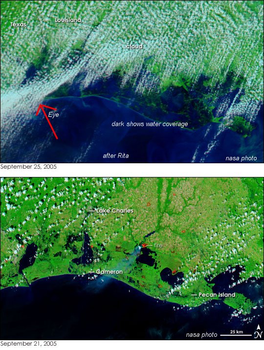
BTW here's the source, lots of pics of Rita.

http://www.nasa.gov/vision/earth/lookingatearth/h2005_rita.html
0 likes   

Matt-hurricanewatcher

#4 Postby Matt-hurricanewatcher » Fri Oct 07, 2005 6:05 pm

Wow the flooding looks worst then Katrina. :eek:
0 likes   

User avatar
wxmann_91
Category 5
Category 5
Posts: 8013
Age: 33
Joined: Fri Jul 15, 2005 2:49 pm
Location: Southern California
Contact:

#5 Postby wxmann_91 » Tue Oct 11, 2005 1:32 am

Another one:

Image
0 likes   

User avatar
vbhoutex
Storm2k Executive
Storm2k Executive
Posts: 29096
Age: 73
Joined: Wed Oct 09, 2002 11:31 pm
Location: Cypress, TX
Contact:

#6 Postby vbhoutex » Tue Oct 11, 2005 1:24 pm

ARe there any more current pics of that area now? Have they drained or are they still flooded?
0 likes   

Rob Beaux
Tropical Depression
Tropical Depression
Posts: 98
Joined: Thu Sep 09, 2004 6:05 pm
Location: MS

#7 Postby Rob Beaux » Tue Oct 11, 2005 1:36 pm

Since alot of that area is wetlands its not that shocking.
0 likes   

User avatar
wxmann_91
Category 5
Category 5
Posts: 8013
Age: 33
Joined: Fri Jul 15, 2005 2:49 pm
Location: Southern California
Contact:

#8 Postby wxmann_91 » Tue Oct 11, 2005 6:04 pm

vbhoutex wrote:ARe there any more current pics of that area now? Have they drained or are they still flooded?


Apparently they are still flooded. Some areas in Cameron Parish might now be permanantly gone now.

Image
0 likes   

User avatar
wxmann_91
Category 5
Category 5
Posts: 8013
Age: 33
Joined: Fri Jul 15, 2005 2:49 pm
Location: Southern California
Contact:

#9 Postby wxmann_91 » Tue Oct 11, 2005 6:13 pm

I've digitally enhanced the picture to make it look more visible and I've circled where the flooding mostly is:

Image

Here is the source of the images: http://wwwghcc.msfc.nasa.gov/GOES/goeseasthurr.html
0 likes   


Return to “Hurricane Recovery and Aftermath”

Who is online

Users browsing this forum: No registered users and 269 guests