NOEL Aftermath
Moderator: S2k Moderators
-
bvigal

- S2K Supporter

- Posts: 2276
- Joined: Sun Jul 24, 2005 8:49 am
- Location: British Virgin Islands
- Contact:
Re: INVEST 90L Threat Area: Puerto Rico,USVI,BVI,N.Leewards
Still raining, and winds are getting gusty. Our power just went a bit ago. This just in from St. Martin airport: SSW (200 degrees) at 19 kt, 35 kt gusts, heavy rain showers
0 likes
-
cycloneye

- Admin

- Posts: 149276
- Age: 69
- Joined: Thu Oct 10, 2002 10:54 am
- Location: San Juan, Puerto Rico
Re: INVEST 90L Threat Area: Puerto Rico,USVI,BVI,N.Leewards
FLOOD WARNING
NATIONAL WEATHER SERVICE SAN JUAN PR
853 PM AST SAT OCT 27 2007
PRC041-045-105-135-137-281300-
853 PM AST SAT OCT 27 2007
THE NATIONAL WEATHER SERVICE IN SAN JUAN HAS ISSUED A
* FLOOD WARNING FOR...
CIDRA MUNICIPALITY IN PUERTO RICO...
COMERIO MUNICIPALITY IN PUERTO RICO...
THIS INCLUDES THE CITY OF COMERIO...
NARANJITO MUNICIPALITY IN PUERTO RICO...
TOA ALTA MUNICIPALITY IN PUERTO RICO...
THIS INCLUDES THE CITIES OF...TOA ALTA...PAJAROS...
TOA BAJA MUNICIPALITY IN PUERTO RICO...
THIS INCLUDES THE CITIES OF...CANDELARIA...CAMPANILLA...
* UNTIL 900 AM AST SUNDAY
* AT 853 PM AST RIVER SENSORS SHOWED THAT THE RIO DE LA PLATA WAS
RISING IN RESPONSE TO WIDESPREAD MODERATE TO HEAVY RAIN OVER THE
BASIN SINCE THIS AFTERNOON. IN ADDITION SOME FLOOD GATES HAVE BEEN
OPENED IN SOME LAKES...THEREFORE THE RIVER IS EXPECTED TO REACH
FLOOD STAGE BEFORE 10 PM AST SATURDAY...OR TONIGHT.
SOME CURRENT RIVER STAGES AS OF 9 PM AST FOR RIO DE LA PLATA...
AT AIBONITO WHERE THE FLOOD STAGE IS 14 FEET THE RIVER IS AT 13.7
FEET
AT COMERIO WHERE FLOOD STAGE IS 11 FEET THE RIVER IS AT 9.7 FEET.
AT TOA ALTA WHERE FLOOD STAGE IS 16 FEET THE RIVER IS AT 14.4 FEET.
AND
AT TOA BAJA WHERE FLOOD STAGE IS 16 FEET THE RIVER IS AT 7.1 FEET.
THE RIVER IS RISING AT THE PRESENT AT ALL OF THESE STATIONS.
A FLOOD WARNING MEANS THAT FLOODING IS IMMINENT OR HAS BEEN REPORTED.
STREAM RISES WILL BE SLOW AND FLASH FLOODING IS NOT EXPECTED.
HOWEVER...ALL INTERESTED PARTIES SHOULD TAKE NECESSARY PRECAUTIONS
IMMEDIATELY.
ADDITIONAL RAINFALL AMOUNTS OF 1 TO 2 INCHES ARE POSSIBLE IN THE
WARNED AREA.
FLOOD WATERS ARE MOVING DOWN RIO DE LA PLATA FROM AIBONITO TO
COMERIO THE FLOOD CREST IS EXPECTED TO REACH THESE LOCATIONS BY 3 AM
AST.
BE ESPECIALLY CAUTIOUS AT NIGHT WHEN IT IS HARDER TO RECOGNIZE THE
DANGERS OF FLOODING. IF FLOODING IS OBSERVED ACT QUICKLY. MOVE UP TO
HIGHER GROUND TO ESCAPE FLOOD WATERS. DO NOT STAY IN AREAS SUBJECT TO
FLOODING WHEN WATER BEGINS RISING.
LAT...LON 1843 6624 1835 6622 1830 6620 1815 6621
1815 6624 1836 6627 1844 6627
TIME...MOT...LOC 0053Z 320DEG 12KT 1833 6622
$$
SNELL
0 likes
-
Derek Ortt

-
cycloneye
- Admin
- Posts: 149276
- Age: 69
- Joined: Thu Oct 10, 2002 10:54 am
- Location: San Juan, Puerto Rico
Re: INVEST 90L Threat Area: Puerto Rico,USVI,BVI,N.Leewards
FLASH FLOOD WARNING
PRC001-009-023-035-043-055-059-067-073-075-079-107-111-113-121-123-12
5-133-149-153-280530-
/O.EXT.TJSJ.FF.W.0029.000000T0000Z-071028T0530Z/
/00000.0.ER.000000T0000Z.000000T0000Z.000000T0000Z.OO/
BULLETIN - EAS ACTIVATION REQUESTED
FLASH FLOOD WARNING
NATIONAL WEATHER SERVICE SAN JUAN PR
917 PM AST SAT OCT 27 2007
THE NATIONAL WEATHER SERVICE IN SAN JUAN HAS EXTENDED THE
* FLASH FLOOD WARNING FOR...
THE FOLLOWING MUNICIPALITIES
IN PUERTO RICO
HORMIGUEROS
COAMO
CAYEY
AIBONITO
JAYUYA
ADJUNTAS
OROCOVIS
SABANA GRANDE
SAN GERMAN
YAUCO
VILLALBA
GUAYANILLA
GUANICA
JUANA DIAZ
PONCE
CABO ROJO
SALINAS
SANTA ISABEL
PENUELAS
LAJAS
* UNTIL 130 AM AST
* AT 910 PM AST...DOPPLER RADAR WAS SHOWING A WIDE BAND OF HEAVY
RAIN APPROACHING THE SOUTH COAST OF PUERTO RICO FROM THE SOUTHEAST.
RAIN IS EXPECTED TO ARRIVE IN BETWEEN 30 TO 90 MINUTES IN THE WARNED
AREA AND WILL KEEP THE AREA SATURATED AND PRONE TO RAPID RISES OF
WATER IN SMALL STREAMS AND ROADWAYS. FOR THIS REASON THE FLASH FLOOD
WARNING HAS BEEN EXTENDED UNTIL 1:30 AM AST.
EXCESSIVE RUNOFF FROM HEAVY RAINFALL WILL CAUSE FLOODING OF SMALL
CREEKS AND STREAMS...HIGHWAYS AND UNDERPASSES. ADDITIONALLY...ROADS
AND LANDS ALONG THE BANKS OF CREEKS...STREAMS AND OTHER LOW LYING
AREAS ARE SUBJECT TO FLOODING. MUDSLIDES ARE NOW BECOMING MORE
COMMON AND NIGHTTIME DRIVING IS HAZARDOUS. IF YOU ARE NOT IN DANGER
PLEASE STAY OUT OF HARMS WAY AND OFF THE ROADWAYS.
TO REPORT FLOODING...HAVE THE NEAREST LAW ENFORCEMENT AGENCY RELAY
YOUR REPORT TO THE NATIONAL WEATHER SERVICE FORECAST OFFICE IN SAN
JUAN.
LAT...LON 1791 6724 1806 6724 1815 6716 1814 6666
1824 6644 1813 6633 1809 6617 1794 6620
1790 6648 1793 6677 1787 6697
TIME...MOT...LOC 0117Z 330DEG 15KT 1721 6615
$$
SNELL
0 likes
-
cycloneye
- Admin
- Posts: 149276
- Age: 69
- Joined: Thu Oct 10, 2002 10:54 am
- Location: San Juan, Puerto Rico
Re:
bvigal wrote:Luis, it sounds like almost all of Puerto Rico is either ponding, flash flooding, or river flooding! What is it like at your house???
It has suddenly settled down here, and power is back, only very light rain. I know some here had water in their homes but haven't heard of anything serious.
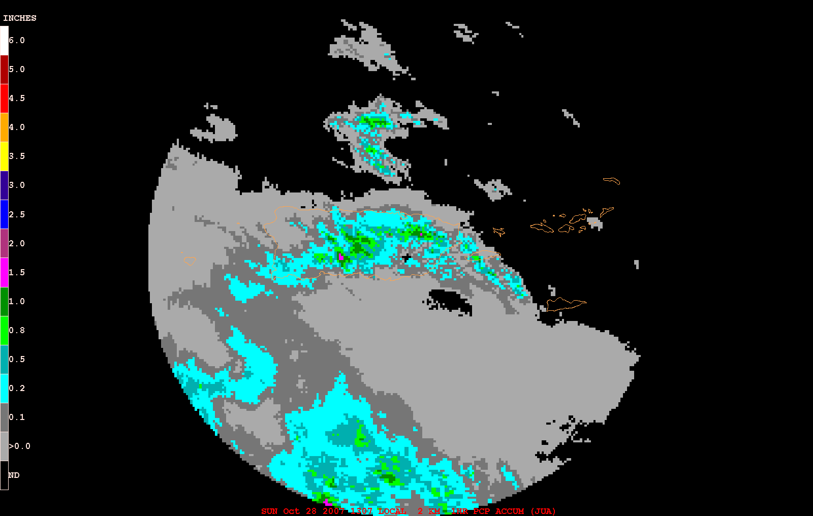
Here in San Juan,it has not been bad with the flooding as the rainfall has not been plenty,so far below 2 inches.However,in southern PR rainfall amounts between 6-8 inches has fallen,causing rivers to go over banks,some mudslides,power off in some parts of the island,dams opening the doors to let the water out.So far 5 deaths are related to 90L since it started to affect PR.2 from the mudslide in Aibonito and three in traffic accidents related to the rain and rapid velocity,a very bad combination.Here also it has slakened in terms of rainfall.
0 likes
-
cycloneye
- Admin
- Posts: 149276
- Age: 69
- Joined: Thu Oct 10, 2002 10:54 am
- Location: San Juan, Puerto Rico
Re: Tropical Depression 16 threat area: PR,USVI,BVI,Haiti,DR,Jam
I included the Dominican Republic,Haiti and Jamaica on the threat area for this thread.I am praying that nothing tragic occurs in those countries especially in Haiti.
0 likes
-
CrazyC83
- Professional-Met

- Posts: 34315
- Joined: Tue Mar 07, 2006 11:57 pm
- Location: Deep South, for the first time!
Re: Re:
cycloneye wrote:bvigal wrote:Luis, it sounds like almost all of Puerto Rico is either ponding, flash flooding, or river flooding! What is it like at your house???
It has suddenly settled down here, and power is back, only very light rain. I know some here had water in their homes but haven't heard of anything serious.
Here in San Juan,it has not been bad with the flooding as the rainfall has not been plenty,so far below 2 inches.However,in southern PR rainfall amounts between 6-8 inches has fallen,causing rivers to go over banks,some mudslides,power off in some parts of the island,dams opening the doors to let the water out.So far 5 deaths are related to 90L since it started to affect PR.2 from the mudslide in Aibonito and three in traffic accidents related to the rain and rapid velocity,a very bad combination.Here also it has slakened in terms of rainfall.
Any news sources on the deaths?
0 likes
-
cycloneye
- Admin
- Posts: 149276
- Age: 69
- Joined: Thu Oct 10, 2002 10:54 am
- Location: San Juan, Puerto Rico
Re: T Depression SIXTEEN threat area: PR,USVI,BVI,Haiti,DR,Jam
0 likes

-
cycloneye
- Admin
- Posts: 149276
- Age: 69
- Joined: Thu Oct 10, 2002 10:54 am
- Location: San Juan, Puerto Rico
Re: Tropical Depression SIXTEEN threat area: Greater Antilles
Great news that all the flash flood warnings that were issued in Puerto Rico were allowed to expire.The only one that is left is the flash flood watch that will be up until early in the morning.
0 likes
-
cycloneye
- Admin
- Posts: 149276
- Age: 69
- Joined: Thu Oct 10, 2002 10:54 am
- Location: San Juan, Puerto Rico
Re: Tropical Depression SIXTEEN threat area: Greater Antilles
Here we go again with more flash flood warnings:
FLASH FLOOD WARNING
PRC007-015-025-035-041-057-063-069-077-085-095-103-109-123-129-151-
281530-
/O.NEW.TJSJ.FF.W.0034.071028T1130Z-071028T1530Z/
/00000.0.ER.000000T0000Z.000000T0000Z.000000T0000Z.OO/
BULLETIN - EAS ACTIVATION REQUESTED
FLASH FLOOD WARNING
NATIONAL WEATHER SERVICE SAN JUAN PR
730 AM AST SUN OCT 28 2007
THE NATIONAL WEATHER SERVICE IN SAN JUAN HAS ISSUED A
* FLASH FLOOD WARNING FOR...
THE FOLLOWING MUNICIPALITIES
IN PUERTO RICO
CAGUAS
CIDRA
CAYEY
AGUAS BUENAS
JUNCOS
GURABO
SAN LORENZO
LAS PIEDRAS
ARROYO
PATILLAS
MAUNABO
NAGUABO
GUAYAMA
HUMACAO
SALINAS
YABUCOA
* UNTIL 1130 AM AST
* AT 724 AM AST...NATIONAL WEATHER SERVICE DOPPLER RADAR INDICATED
BANDS OF HEAVY RAINS AND ISOLATED THUNDERSTORMS MOVING NORTHWEST
ACROSS THE SOUTHEAST...EASTERN INTERIOR AND NORTHEAST SECTIONS OF
PUERTO RICO.
* LOCATIONS IN THE WARNING INCLUDE BUT ARE NOT LIMITED TO GUAYAMA...
YABUCOA...SAN LORENZO...PUNTA SANTIAGO...PLAYITA...PATILLAS...
PALMAS...OLIMPO...NAGUABO...MARTORELL...LA FERMINA...LAS PIEDRAS...
JUNCOS...HUMACAO...EMAJAGUA...MAUNABO...CORAZON...CIDRA...CELADA...
GURABO...CAYEY...CAGUAS...BUENA VISTA...BAIROA AND ANTON RUIZ
A FLASH FLOOD WARNING MEANS THAT FLOODING IS IMMINENT OR OCCURRING.
IF YOU ARE IN THE WARNING AREA MOVE TO HIGHER GROUND IMMEDIATELY.
RESIDENTS LIVING ALONG STREAMS AND CREEKS SHOULD TAKE IMMEDIATE
PRECAUTIONS TO PROTECT LIFE AND PROPERTY. DO NOT ATTEMPT TO CROSS
SWIFTLY FLOWING WATERS OR WATERS OF UNKNOWN DEPTH BY FOOT OR BY
AUTOMOBILE.
LAT...LON 1794 6618 1817 6622 1828 6605 1824 6566
1798 6587
TIME...MOT...LOC 1130Z 180DEG 0KT 1798 6603
$$
RM
--------------------------------------------------------------------------------
FLASH FLOOD WARNING
PRC077-085-129-281245-
/O.NEW.TJSJ.FF.W.0033.071028T1051Z-071028T1245Z/
/00000.0.ER.000000T0000Z.000000T0000Z.000000T0000Z.OO/
BULLETIN - EAS ACTIVATION REQUESTED
FLASH FLOOD WARNING
NATIONAL WEATHER SERVICE SAN JUAN PR
651 AM AST SUN OCT 28 2007
THE NATIONAL WEATHER SERVICE IN SAN JUAN HAS ISSUED A
* FLASH FLOOD WARNING FOR...
THE FOLLOWING MUNICIPALITIES
IN PUERTO RICO
JUNCOS
SAN LORENZO
LAS PIEDRAS
* UNTIL 845 AM AST
* AT 645 AM AST...NATIONAL WEATHER SERVICE DOPPLER RADAR INDICATED
FLASH FLOODING FROM HEAVY RAINS OCCURRING OVER THE WARNED AREA.
RAINFALL RATES OF OVER TWO INCHES PER HOUR ARE POSSIBLE AND GROUNDS
ARE SATURATED.
A FLASH FLOOD WARNING MEANS THAT FLOODING IS IMMINENT OR OCCURRING.
IF YOU ARE IN THE WARNING AREA MOVE TO HIGHER GROUND IMMEDIATELY.
RESIDENTS LIVING ALONG STREAMS AND CREEKS SHOULD TAKE IMMEDIATE
PRECAUTIONS TO PROTECT LIFE AND PROPERTY. DO NOT ATTEMPT TO CROSS
SWIFTLY FLOWING WATERS OR WATERS OF UNKNOWN DEPTH BY FOOT OR BY
AUTOMOBILE.
LAT...LON 1820 6583 1813 6588 1816 6598 1823 6591
TIME...MOT...LOC 1051Z 180DEG 0KT 1798 6603
$$
RM
Good morning fellow Caribbean members.As long TD 16 continues to move slowly or is stationary,it will keep throwing bands of rain towards Puerto Rico. It didnt rained in San Juan until 6 AM when it started again in a moderate to heavy range.I am again typing with a jacket as is feels cool.
FLASH FLOOD WARNING
PRC007-015-025-035-041-057-063-069-077-085-095-103-109-123-129-151-
281530-
/O.NEW.TJSJ.FF.W.0034.071028T1130Z-071028T1530Z/
/00000.0.ER.000000T0000Z.000000T0000Z.000000T0000Z.OO/
BULLETIN - EAS ACTIVATION REQUESTED
FLASH FLOOD WARNING
NATIONAL WEATHER SERVICE SAN JUAN PR
730 AM AST SUN OCT 28 2007
THE NATIONAL WEATHER SERVICE IN SAN JUAN HAS ISSUED A
* FLASH FLOOD WARNING FOR...
THE FOLLOWING MUNICIPALITIES
IN PUERTO RICO
CAGUAS
CIDRA
CAYEY
AGUAS BUENAS
JUNCOS
GURABO
SAN LORENZO
LAS PIEDRAS
ARROYO
PATILLAS
MAUNABO
NAGUABO
GUAYAMA
HUMACAO
SALINAS
YABUCOA
* UNTIL 1130 AM AST
* AT 724 AM AST...NATIONAL WEATHER SERVICE DOPPLER RADAR INDICATED
BANDS OF HEAVY RAINS AND ISOLATED THUNDERSTORMS MOVING NORTHWEST
ACROSS THE SOUTHEAST...EASTERN INTERIOR AND NORTHEAST SECTIONS OF
PUERTO RICO.
* LOCATIONS IN THE WARNING INCLUDE BUT ARE NOT LIMITED TO GUAYAMA...
YABUCOA...SAN LORENZO...PUNTA SANTIAGO...PLAYITA...PATILLAS...
PALMAS...OLIMPO...NAGUABO...MARTORELL...LA FERMINA...LAS PIEDRAS...
JUNCOS...HUMACAO...EMAJAGUA...MAUNABO...CORAZON...CIDRA...CELADA...
GURABO...CAYEY...CAGUAS...BUENA VISTA...BAIROA AND ANTON RUIZ
A FLASH FLOOD WARNING MEANS THAT FLOODING IS IMMINENT OR OCCURRING.
IF YOU ARE IN THE WARNING AREA MOVE TO HIGHER GROUND IMMEDIATELY.
RESIDENTS LIVING ALONG STREAMS AND CREEKS SHOULD TAKE IMMEDIATE
PRECAUTIONS TO PROTECT LIFE AND PROPERTY. DO NOT ATTEMPT TO CROSS
SWIFTLY FLOWING WATERS OR WATERS OF UNKNOWN DEPTH BY FOOT OR BY
AUTOMOBILE.
LAT...LON 1794 6618 1817 6622 1828 6605 1824 6566
1798 6587
TIME...MOT...LOC 1130Z 180DEG 0KT 1798 6603
$$
RM
--------------------------------------------------------------------------------
FLASH FLOOD WARNING
PRC077-085-129-281245-
/O.NEW.TJSJ.FF.W.0033.071028T1051Z-071028T1245Z/
/00000.0.ER.000000T0000Z.000000T0000Z.000000T0000Z.OO/
BULLETIN - EAS ACTIVATION REQUESTED
FLASH FLOOD WARNING
NATIONAL WEATHER SERVICE SAN JUAN PR
651 AM AST SUN OCT 28 2007
THE NATIONAL WEATHER SERVICE IN SAN JUAN HAS ISSUED A
* FLASH FLOOD WARNING FOR...
THE FOLLOWING MUNICIPALITIES
IN PUERTO RICO
JUNCOS
SAN LORENZO
LAS PIEDRAS
* UNTIL 845 AM AST
* AT 645 AM AST...NATIONAL WEATHER SERVICE DOPPLER RADAR INDICATED
FLASH FLOODING FROM HEAVY RAINS OCCURRING OVER THE WARNED AREA.
RAINFALL RATES OF OVER TWO INCHES PER HOUR ARE POSSIBLE AND GROUNDS
ARE SATURATED.
A FLASH FLOOD WARNING MEANS THAT FLOODING IS IMMINENT OR OCCURRING.
IF YOU ARE IN THE WARNING AREA MOVE TO HIGHER GROUND IMMEDIATELY.
RESIDENTS LIVING ALONG STREAMS AND CREEKS SHOULD TAKE IMMEDIATE
PRECAUTIONS TO PROTECT LIFE AND PROPERTY. DO NOT ATTEMPT TO CROSS
SWIFTLY FLOWING WATERS OR WATERS OF UNKNOWN DEPTH BY FOOT OR BY
AUTOMOBILE.
LAT...LON 1820 6583 1813 6588 1816 6598 1823 6591
TIME...MOT...LOC 1051Z 180DEG 0KT 1798 6603
$$
RM
Good morning fellow Caribbean members.As long TD 16 continues to move slowly or is stationary,it will keep throwing bands of rain towards Puerto Rico. It didnt rained in San Juan until 6 AM when it started again in a moderate to heavy range.I am again typing with a jacket as is feels cool.
0 likes


-
cycloneye
- Admin
- Posts: 149276
- Age: 69
- Joined: Thu Oct 10, 2002 10:54 am
- Location: San Juan, Puerto Rico
Re: Tropical Depression SIXTEEN threat area: Greater Antilles
--------------------------------------------------------------------------------
FLASH FLOOD WARNING
PRC001-009-019-043-055-059-073-075-079-107-111-113-121-133-141-149-
153-281530-
/O.NEW.TJSJ.FF.W.0035.071028T1226Z-071028T1530Z/
/00000.0.ER.000000T0000Z.000000T0000Z.000000T0000Z.OO/
BULLETIN - EAS ACTIVATION REQUESTED
FLASH FLOOD WARNING
NATIONAL WEATHER SERVICE SAN JUAN PR
826 AM AST SUN OCT 28 2007
THE NATIONAL WEATHER SERVICE IN SAN JUAN HAS ISSUED A
* FLASH FLOOD WARNING FOR...
THE FOLLOWING MUNICIPALITIES
IN PUERTO RICO
COAMO
AIBONITO
BARRANQUITAS
JAYUYA
ADJUNTAS
OROCOVIS
SABANA GRANDE
UTUADO
YAUCO
VILLALBA
GUAYANILLA
GUANICA
JUANA DIAZ
PONCE
SANTA ISABEL
PENUELAS
LAJAS
* UNTIL 1130 AM AST
* AT 822 AM AST...NATIONAL WEATHER SERVICE DOPPLER RADAR SHOWED
AN AREA OF SHOWERS AND THUNDERSTORMS WITH VERY HEAVY RAINFALL MOVING
OVER OR TOWARDS THE WARNED AREA.
EXCESSIVE RUNOFF FROM HEAVY RAINFALL WILL CAUSE FLOODING OF SMALL
CREEKS AND STREAMS...HIGHWAYS AND UNDERPASSES. ADDITIONALLY...ROADS
AND LANDS ALONG THE BANKS OF CREEKS...STREAMS AND OTHER LOW LYING
AREAS ARE SUBJECT TO FLOODING.
A FLASH FLOOD WARNING MEANS THAT FLOODING IS IMMINENT OR OCCURRING.
IF YOU ARE IN THE WARNING AREA MOVE TO HIGHER GROUND IMMEDIATELY.
RESIDENTS LIVING ALONG STREAMS AND CREEKS SHOULD TAKE IMMEDIATE
PRECAUTIONS TO PROTECT LIFE AND PROPERTY. DO NOT ATTEMPT TO CROSS
SWIFTLY FLOWING WATERS OR WATERS OF UNKNOWN DEPTH BY FOOT OR BY
AUTOMOBILE.
DO NOT UNDERESTIMATE THE POWER OF FLOOD WATERS. ONLY A FEW INCHES OF
RAPIDLY FLOWING WATER CAN QUICKLY CARRY AWAY YOUR VEHICLE.
LAT...LON 1796 6705 1813 6656 1814 6680 1831 6682
1833 6680 1835 6675 1833 6658 1817 6653
1825 6650 1828 6642 1825 6628 1818 6624
1795 6635
TIME...MOT...LOC 1226Z 180DEG 0KT 1803 6659
$$
RAM
FLASH FLOOD WARNING
PRC001-009-019-043-055-059-073-075-079-107-111-113-121-133-141-149-
153-281530-
/O.NEW.TJSJ.FF.W.0035.071028T1226Z-071028T1530Z/
/00000.0.ER.000000T0000Z.000000T0000Z.000000T0000Z.OO/
BULLETIN - EAS ACTIVATION REQUESTED
FLASH FLOOD WARNING
NATIONAL WEATHER SERVICE SAN JUAN PR
826 AM AST SUN OCT 28 2007
THE NATIONAL WEATHER SERVICE IN SAN JUAN HAS ISSUED A
* FLASH FLOOD WARNING FOR...
THE FOLLOWING MUNICIPALITIES
IN PUERTO RICO
COAMO
AIBONITO
BARRANQUITAS
JAYUYA
ADJUNTAS
OROCOVIS
SABANA GRANDE
UTUADO
YAUCO
VILLALBA
GUAYANILLA
GUANICA
JUANA DIAZ
PONCE
SANTA ISABEL
PENUELAS
LAJAS
* UNTIL 1130 AM AST
* AT 822 AM AST...NATIONAL WEATHER SERVICE DOPPLER RADAR SHOWED
AN AREA OF SHOWERS AND THUNDERSTORMS WITH VERY HEAVY RAINFALL MOVING
OVER OR TOWARDS THE WARNED AREA.
EXCESSIVE RUNOFF FROM HEAVY RAINFALL WILL CAUSE FLOODING OF SMALL
CREEKS AND STREAMS...HIGHWAYS AND UNDERPASSES. ADDITIONALLY...ROADS
AND LANDS ALONG THE BANKS OF CREEKS...STREAMS AND OTHER LOW LYING
AREAS ARE SUBJECT TO FLOODING.
A FLASH FLOOD WARNING MEANS THAT FLOODING IS IMMINENT OR OCCURRING.
IF YOU ARE IN THE WARNING AREA MOVE TO HIGHER GROUND IMMEDIATELY.
RESIDENTS LIVING ALONG STREAMS AND CREEKS SHOULD TAKE IMMEDIATE
PRECAUTIONS TO PROTECT LIFE AND PROPERTY. DO NOT ATTEMPT TO CROSS
SWIFTLY FLOWING WATERS OR WATERS OF UNKNOWN DEPTH BY FOOT OR BY
AUTOMOBILE.
DO NOT UNDERESTIMATE THE POWER OF FLOOD WATERS. ONLY A FEW INCHES OF
RAPIDLY FLOWING WATER CAN QUICKLY CARRY AWAY YOUR VEHICLE.
LAT...LON 1796 6705 1813 6656 1814 6680 1831 6682
1833 6680 1835 6675 1833 6658 1817 6653
1825 6650 1828 6642 1825 6628 1818 6624
1795 6635
TIME...MOT...LOC 1226Z 180DEG 0KT 1803 6659
$$
RAM
0 likes
-
bvigal
- S2K Supporter
- Posts: 2276
- Joined: Sun Jul 24, 2005 8:49 am
- Location: British Virgin Islands
- Contact:
Re: Tropical Depression SIXTEEN threat area: Greater Antilles
Good morning NEIGHBORS! A quiet overnight here, the towel under the roof leak dried (I really should invest in a proper rain gauge!) A noticable difference, the air here at 1000+ft. is warmer.
Very distressing to see the continuing flooding in PR - with ground saturated, it doesn't take much rain. I fear much worse for DR/Haiti. Let's pray that with all the rain moving E to W the last 3 days, awareness in DR/H has spread to the most remote locations, and people there are taking the flooding threat seriously.
Very distressing to see the continuing flooding in PR - with ground saturated, it doesn't take much rain. I fear much worse for DR/Haiti. Let's pray that with all the rain moving E to W the last 3 days, awareness in DR/H has spread to the most remote locations, and people there are taking the flooding threat seriously.
0 likes
The thing about Haiti is, though, even with an understanding of the severity, where would they go? What would they do? The most vulnerable have so little for daily life, let alone protection against the weather. It is a seriously depressing situation there, close to impossible for most in the Western Hemisphere to imagine.
This is from an article on a site called Socialist Action that succinctly sums up the reality, with the rest of the article addressing many of the reasons:
"People living outside the major towns and cities have no electricity, so they burn wood for cooking, heat, and light. Otherwise, trees are used to make charcoal, which is sold to the urban dwellers. In a country where the unemployment rate is 80 percent and the majority population lives on less than $1/day, any means of income is highly sought after."
This isn't far off Africa, this is right here, in our part of the world, and beyond my imagination, even having seen some very poor places in the islands.
Sorry for the slightly OT digression, but...for those who don't understand why those of us in the islands always get upset when Haiti is in the crosshairs, this is the reason, as not only lives are lost, but for those who get through, any crops and livestock they HAVE managed to produce gets swept away as well, meaning once again starting over.
0 likes

Re: Tropical Depression SIXTEEN threat area: Greater Antilles
good morning neighbors.
we are starting to dry out here, I think.
Glad to hear some of you are drying out also.
But I said yesterday that we were drying out and then later in the day we got torrential rains again.
It rained on and off for most of the night.
I lost count of how much rain we have had over the past few days.
I just know everywhere I go, I am walking on soggy ground and in puddles.
and I am still cold.
the skies are still totally cloudy here, but they are a little brighter so obviously the cloud cover is not as thick.
I hope DR and Haiti people stay safe and don't get too much flooding.
Barbara
0 likes
-
Derek Ortt
Return to “Hurricane Recovery and Aftermath”
Who is online
Users browsing this forum: No registered users and 14 guests