
For those that are extremely knowledgeable, has anyone created a timeline for some of the criticial decisions/events that have occurred? I think a timeline of the important events could expose where leadership may have failed. Some of the issues I am curious about:
- When the initial decision to build the levies to withstand only a Category 3 hurricane was made and any budget changes since then? Obviously it was a cost-benefit type of decision that should have been revisited as N.O. has grown.
- When and what studies were completed indicating the impact of a Category 3 + hurricane hitting N.O.?
- When did the NHC forecasted path point to N.O. with + Category 3 strength and did the NHC advise evacuation? When did the ultimate evacuation order occur and was it mandatory? I have seen pictures of flooded school buses that are evidently part of N.O. evacuation plan. Obviously, if more of the poor New Orlean residents had been bused out, it would have reduced some of the problems post-hurricane.
- When did President Bush indicate a state of emergency and what action was taken? It seems to me that ships from Norfolk should have left at that time and other resources should have been positioned. What action was taken?
These are just some of the issues, and they do not only touch only on current leadership. Prior congresses and presidents have made decisions impacting this situation. Leadership at city, state, and federal levels of both parties should be accountable. It seems that many of the results were predictable and should have been anticipated.
An aside: In all of this mess (because I haven't seen it mentioned too much), the Coast Guard and the crew from the one Naval ship quickly on site really did an amazing job as did many other groups I am sure. I saw it reported that the Coast Guard save 5,500 people in their rescues.
Has anyone generated a timeline?
Moderator: S2k Moderators
Has anyone generated a timeline?
0 likes

-
x-y-no

- Category 5

- Posts: 8359
- Age: 65
- Joined: Wed Aug 11, 2004 12:14 pm
- Location: Fort Lauderdale, FL
artist wrote:seems La. authorities were made aware of the fact that Katrina was going to be a cat 5 headed there 5 days before she got there.
Uhhh ... no.
Here's the forecast advisory exactly 5 days before landfall:
FORECAST VALID 24/1800Z 24.7N 77.1W
MAX WIND 40 KT...GUSTS 50 KT.
34 KT... 90NE 90SE 50SW 0NW.
FORECAST VALID 25/0600Z 25.5N 78.0W
MAX WIND 45 KT...GUSTS 55 KT.
34 KT... 90NE 90SE 60SW 30NW.
FORECAST VALID 25/1800Z 25.9N 78.9W
MAX WIND 50 KT...GUSTS 60 KT.
50 KT... 35NE 25SE 25SW 35NW.
34 KT... 90NE 75SE 60SW 60NW.
FORECAST VALID 26/0600Z 26.1N 80.0W
MAX WIND 60 KT...GUSTS 75 KT.
50 KT... 35NE 25SE 25SW 35NW.
34 KT... 75NE 60SE 60SW 75NW.
FORECAST VALID 27/0600Z 26.5N 82.0W...INLAND
MAX WIND 40 KT...GUSTS 50 KT.
34 KT... 75NE 60SE 60SW 75NW.
EXTENDED OUTLOOK. NOTE...ERRORS FOR TRACK HAVE AVERAGED NEAR 250 NM
ON DAY 4 AND 325 NM ON DAY 5...AND FOR INTENSITY NEAR 20 KT EACH DAY
OUTLOOK VALID 28/0600Z 27.0N 84.0W...OVER WATER
MAX WIND 55 KT...GUSTS 65 KT.
OUTLOOK VALID 29/0600Z 28.0N 86.5W
MAX WIND 65 KT...GUSTS 80 KT.
Care to point out where it says anything about a Cat 5?
0 likes
Pulling up the past posts, Derek Ortt predicted a Category 4 hitting the N.O. area on Friday, 9 a.m., a little over 72 hours out. I know NHC lagged this prediction some. I think they were in the process of moving it from a panhandle landfall to N.O. area.
Derek made his "worst day for the United States this Monday" post Saturday at 4:24 p.m., which was 36-48 hours pre-landfall. At this point, I think the NHC had a similar track. I remember I was going crazy Saturday evening wondering why it seemed there was no emphasis on evacuation coming from local N.O. officials. I think the call for evacuation came on Sunday noon/afternoon after reportedly President Bush put some pressure on the Louisiana Governor. I know he ordered/signed the state of emergency order some time pre-landfall.
Derek made his "worst day for the United States this Monday" post Saturday at 4:24 p.m., which was 36-48 hours pre-landfall. At this point, I think the NHC had a similar track. I remember I was going crazy Saturday evening wondering why it seemed there was no emphasis on evacuation coming from local N.O. officials. I think the call for evacuation came on Sunday noon/afternoon after reportedly President Bush put some pressure on the Louisiana Governor. I know he ordered/signed the state of emergency order some time pre-landfall.
0 likes
this is according to the information that Bill O'Reilly was given on Fox news. and if I recall correctly the gfdl was predicting a cat 5 going into the gulf for quite some time. Could it be they were given a heads up early this could be a possibility? According to O'Reilly's resources it was done.
0 likes
Brent, that was my impression, that Saturday was the day that the local officials should have ordered evacuation. The NHC and all of the other experts had the same impression and were encouraging evacuation. At that point, they could have utilized what I understand is part of their evacuation plan, school buses and other buses to get the poor people out.
It seems from reports that President Bush was very proactive with pushing evacuation and signing the emergency order in that Saturday to Sunday range. However, I still don't understand why the federal government did not start moving ships from Norfolk or position more resources at that point.
It seems from reports that President Bush was very proactive with pushing evacuation and signing the emergency order in that Saturday to Sunday range. However, I still don't understand why the federal government did not start moving ships from Norfolk or position more resources at that point.
0 likes
-
x-y-no
- Category 5
- Posts: 8359
- Age: 65
- Joined: Wed Aug 11, 2004 12:14 pm
- Location: Fort Lauderdale, FL
artist wrote:this is according to the information that Bill O'Reilly was given on Fox news. and if I recall correctly the gfdl was predicting a cat 5 going into the gulf for quite some time. Could it be they were given a heads up early this could be a possibility? According to O'Reilly's resources it was done.
The GFDL had a Cat 3 hitting Key Largo. That clearly wasn't credible, and thus called into question the later track and intensity. Most of the model guidance was not that extreme.
Certainly, there was general discussion of potential for an intensifying storm in the Gulf. But intensity might have been aything from a minor hurricane to a major, and landfall might have been anything from the big bend to the TX/LA border. Actually, some model guidance was further west than that.
No, the time when the threat became serious enough to act on for the eventually affected areas was Friday during the day, and mandatory evacs should have been ordered no later than early afternoon of Saturday.
0 likes
-
x-y-no
- Category 5
- Posts: 8359
- Age: 65
- Joined: Wed Aug 11, 2004 12:14 pm
- Location: Fort Lauderdale, FL
morgan wrote:Brent, that was my impression, that Saturday was the day that the local officials should have ordered evacuation. The NHC and all of the other experts had the same impression and were encouraging evacuation. At that point, they could have utilized what I understand is part of their evacuation plan, school buses and other buses to get the poor people out.
It seems from reports that President Bush was very proactive with pushing evacuation and signing the emergency order in that Saturday to Sunday range. However, I still don't understand why the federal government did not start moving ships from Norfolk or position more resources at that point.
I agree with both those points.
0 likes
-
soonertwister
- Category 5
- Posts: 1091
- Joined: Mon Jun 16, 2003 2:52 pm
The federal government was moving an entire joint task force (this is a huge group of people) by Wednesday morning, and we were just becoming aware of a really big crisis in New Orleans less than 24 hours before deployal. Some of the advance elements of the JTF were on scene by around Thursday noon, and many people were already involved in rescue operations, some independent some organized, even before then.
Nobody can be a miracle worker. By all early accounts New Orleans dodged a bullet and suffered relatively minimal damage compared to areas east of the Mississippi and west of Florida. It's likely that many involved in the relief effort who had to move in assistance on the ground were already prepositioning on the east side of the Mississippi River before the news became very frightening from New Orleans.
That would have required a massive realignment of supplies and warm bodies, since the only route into NOLA from east of the big river was over the Pontchartrain Bridge, and I'm not sure if they knew at that time that the bridge would be usable or would handle the massive weight loads involved with the rescue effort.
Those who have been roundly blistering the Red Cross and federal rescue effort are going to end up with egg on their faces after all the facts are known.
0 likes
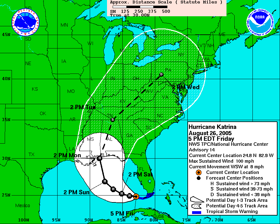
Based on the info on this thread and other info on this board:
- 10/04- Article after Ivan predicting the present situation if Ivan had not turned
- 11 p.m., Friday, NHC indicates Cat 4 to N.O. (exceeding engineering specs on levee system)
- Sat. noon-afternoon- NHC & other experts push for evacuation
- Sun. afternoon- Voluntary? evacuation finally called for by local officials (under pressure from President Bush)
- Sun. afternoon/evening- President Bush signs emergency order, but no ships from Norfolk and unknown what other resources were being put into place.
I think we have to question the slow evacuation declaration by local N.O. officials based on the above. I know the levee project created to withstand a Cat 3 and the Tulane/LSU evaluation took place well prior to 2005.
I also think the federal response (based on the levee engineering and Tulane/LSU report) should have assumed the worst throughout. It appears they thought everything was fine until the levee crisis which I believe developed on Tuesday.
0 likes
soonertwister wrote:The federal government was moving an entire joint task force (this is a huge group of people) by Wednesday morning, and we were just becoming aware of a really big crisis in New Orleans less than 24 hours before deployal. Some of the advance elements of the JTF were on scene by around Thursday noon, and many people were already involved in rescue operations, some independent some organized, even before then.
Nobody can be a miracle worker. By all early accounts New Orleans dodged a bullet and suffered relatively minimal damage compared to areas east of the Mississippi and west of Florida. It's likely that many involved in the relief effort who had to move in assistance on the ground were already prepositioning on the east side of the Mississippi River before the news became very frightening from New Orleans.
That would have required a massive realignment of supplies and warm bodies, since the only route into NOLA from east of the big river was over the Pontchartrain Bridge, and I'm not sure if they knew at that time that the bridge would be usable or would handle the massive weight loads involved with the rescue effort.
Those who have been roundly blistering the Red Cross and federal rescue effort are going to end up with egg on their faces after all the facts are known.
Clearly, no one could anticipate the cut off from the east versus other directions (as far as I know). I do think that a potential levee break and rising water equal to the Mississippi or Lake P should have been anticipated depending on where the breach occurred.
I just know that there are people that are more knowledgeable on these processes on the board, and a lot of what I have seen have been very partisan. Based on what I have seen, I believe this scenario should have been anticipated and (1) an evacuation should have been ordered earlier by local N.O. officials (which makes the N.O. Mayor's ranting less credible), and (2) federal and other resources should have anticipated the flooding and been moving into position. I believe this cuts across party lines.
If a lot of the federal resources were positioned in the east, I wish they would say that because that would make sense. It just appears that the government thought the crisis was averted when the storm passed on Monday and N.O. wasn't flooded.
P.S. Just saw on CNN that the Coast Guard has rescued 10K+- pretty impressive.
0 likes
-
soonertwister
- Category 5
- Posts: 1091
- Joined: Mon Jun 16, 2003 2:52 pm
Morgan, I was one of a very few that were cautioning that we really didn't know whether or not NOLA dodged the bullet, and that was as of late Monday evening, when revelers were out en masse in the French Quarter, celebrating their good fortune and getting very drunk and stupid.
Most people at that time were talking about how lucky NOLA was that the western eyewall hadn't hit the town, while I was still concerned about the effects of the water that had been pushed into Pontchartrain from the storm surge, given the incredible stories about surge I was hearing from well inland in Mississippi and the flood stage in downtown Mobile.
At that time I'm not sure if anyone outside of the immediate location knew that the Pontchartrain levee had overwashed as a result of the surge in northern St. Bernard Parish, deeply flooding thousands of homes. Even as the sun came up on Tuesday morning the impression was out that there would be a heck of a lot of damage, and likely quite a few coastal fatalaties to the east of New Orleans. Pretty much almost no one realized how dire the situation already was in the NOLA metro area proper to the east of Orleans Parish.
When the first reports came in of a small levee break, originally reported as 40-60 feet wide, that was starting to slowly flood eastern Orleans Parish, people still pretty much believed that could be plugged in short order, and things would stabilize. No one understood that an overwash to the west of eastern Orleans would lead to the erosion of the foundation soil of the levee on that side.
It really was around noon before the alarm bells started ringing, but it wasn't until sometime late Tuesday afternoon or earlier that evening that even the people who were following the story closely were beginning to really understand that the situation was spinning out of control, and that we might not be able to stop it.
But one of the events that made this so tragic was already starting before the daylight morning hours of Tuesday dawned. Sporadic groups of looters, starting with small bands of people more concerned with stocking up with survivables than stealing other things, started to break into businesses because of the lack of police presence. The police were for the most part focused on rescue efforts to the east, and didn't understand that the lack of their presence on the street would appear to some people that they had been abandoned in the city.
As the levee breaks grew and the water started rising, the huge unevacuated populations of Orleans Parish started to get uneasy, and for many of them, fueled by alcohol from their partying binges, and the lack of civil authority accompanied by steadily declining conditions, became much bolder. Some probably thought about barter for those goods that no longer available on shelves of looted buildings. Drug addicts needed no added incentives to maraud for drugs, and the free-for-all was on.
By Wednesday morning, the situation in the city was growing increasingly dire, an those seeking assistance to escape their plight started migrating in very large numbers toward places where they felt that help was on the way, especially the Superdome and the Convention Center. Many who were farther from those landmarks sought dry spots on the interstate highway, thinking that someone would likely rescue them soon.
And I could go on, but you can see where this narrative is taking us. There were people in desperate need of help in eastern Orleans Parish, St. Bernard Parish immediately to the east of that was inundated, infrastructure and communications made the city an island of desperation and horror.
It's good to closely examine the timeline, because it provides many explanations to the decisions that were made, especially in the natural instinct to save lives most in danger first. The first responders were using intuitive triage to focus their efforts on saving those most in danger of dying first, and ignoring the civil disorder and the huge masses of people congregating at a few points, undoubtedly assuming that help would soon be on the way.
No one could have imagined the nightmare that was to become the Superdome in advance. But this entire tale, when accurately told, will give us the greatest blueprint to save lives in the future that has ever been created by a natural disaster, much as the wreck of the Titanic began the safety reform movement in passenger ship voyages, and the Coconut Grove nightclub fire helped modernize fire safety codes.
It's sad that we have to have these massive disasters to wake us up to the perils, but the simple fact is that the human mind cannot wrap itself around many of the consequences of these novel events, they have to be experienced to be understood.
We will understand, we will change, and we will all be safer in the future as a result. Societies survive by learning and evolving, and we just got taught a lesson that's never been put into the textbook.
0 likes
sooner,
I remember seeing yours and other posts regarding not really knowing Monday evening, and I know that was what I was feeling...while my impression is that most others, including possibly government officials, were writing off the threat. I guess my belief is that everyone knew that N.O.'s levee system was most likely to give if a Cat 3 + hit it. Clearly, it appears that local N.O. officials waited too late to order evacuation.
Pre and post storm, I believe everyone should have assumed a possible levee break and reacted for it. I know President Bush was proactive early, but who had the resposibility for the next step (positioning ships, more troops, etc.) and did they do their job?
I ultimately don't believe in the race accusations or the democratic and republican finger pointing, but believe a number of groups/political divisions dropped the ball. That shouldn't take away from the Coast Guard, those N.O. policemen that stayed on post, the state of Texas, or the Salvation Army & Red Cross who as far as I know always does a great job (and shouldn't be counted on as first responders).
0 likes
-
SouthFloridawx

- S2K Supporter

- Posts: 8346
- Age: 47
- Joined: Tue Jul 26, 2005 1:16 am
- Location: Sarasota, FL
- Contact:
-
SouthFloridawx
- S2K Supporter
- Posts: 8346
- Age: 47
- Joined: Tue Jul 26, 2005 1:16 am
- Location: Sarasota, FL
- Contact:

-
soonertwister
- Category 5
- Posts: 1091
- Joined: Mon Jun 16, 2003 2:52 pm
At 5 am EDT Saturday morning, the official NHC forecast track had NOLA in the bullseye, with the center of their track right over New Orleans.
It is estimated that it takes 60 to 72 hours to fully evacuate New Orleans, if all disaster planning is followed.
By 7 am CDT on Saturday, Katrina was a major category 3 hurricane, and was forecast to strengthen, possibly to a devastating category 4 hurricane. Tropical storm intensity is the most uncertain of all variables in forecasting tropical storms, and the NHC itself warns that intensity levels one higher or lower than forecast are very common. This means that according to their own advice, at roughly 48 hours from eventual landfall, a significant possibility of a category 5 hurricane already existed.
The official track was just to the east of NOLA proper, and the swath of hurricane force winds extended out 85 miles.
New Orleans had a levy that was designed to survive a category 3 hurricane, but was projected to have serious storm surge flooding or worse in a category 4 hurricane, or catastrophic flooding in a category 5, with storm surge more than 10 feet over the levee with a direct hit.
At 7 pm Saturday, approximately 37 hours from landfall, Katrina was an enormous and incredibly powerful hurricane with sustained winds of 175 miles per hour. It would retain that wind speed for more than 24 hours.
After the most dire possible consequences were possible, New Orleans Mayor Nagin said he wanted to sleep on a decision to issue an order to evacuate, and noted that these hurricanes frequently turn away from NOLA, or weaken dramatically before striking the city. At the time of this statement, maximum wave heights in the open Gulf were exceeeding 65 feet, and possible storm surge was estimated to be 22 feet or more.
Early Sunday morning, Mayor Nagin announced that there would be a meeting between himself and emergency officials after which the decision would be made as to whether or not to evacuate New Orleans. At roughly 11 am CDT Sunday morning, Nagin ordered a complete evacuation of New Orleans, but did not initiate his city's own emergency evacuation plan, which was to use all buses and public transportation to evacuate the poor, the physically disadvantaged, and the elderly. It could be that the personnel to implement that plan were no longer available within the city to contact. When the evacuation order went into effect, it was less than 21 hours to landfall of Hurricane Katrina in southeast Louisiana.
Near this time, President Bush declared areas of the middle GOM states, including New Orleans, as disaster areas, which allowed mobilization of federal disaster response teams in advance of the likely major disaster. The clock started for a mobilization on the Gulf coast of large numbers of emergency response and rescue resources.
Katrina made landfall in Louisiana less than 21 hours after the evacuation order by Nagin, which made total evacuation of remaining persons impossible. Most of the poor and disabled, and nearly all of the cared-for elderly, are left in place to wait out the storm.
Somewhere around 7 am Monday morning Katrina makes her second of three landfalls in the United States. About 4 hours later, the west eyewall of Katrina passes directly over eastern New Orleans, but much more powerful winds are to the east, and it seems apparent that all of the most significant storm surge has missed New Orleans as well, although areas from immediately to the east of New Orleans all the way to Mobile are severely to catastrophically impacted.
At this time, it appears that New Orleans has dodged the worst of terrible Hurricane Katrina, and has avoided the potential "worst-case scenario".
We were dreaming.
(Note: I believe this timetable is substantially correct, but some minor adjustments of times may be necessary to make it 100% correct. As it stands, I believe that it is easily as accurate as it needs to be at this time.)
Last edited by soonertwister on Sat Sep 03, 2005 12:19 am, edited 2 times in total.
0 likes
-
Brent
- S2K Supporter
- Posts: 38778
- Age: 37
- Joined: Sun May 16, 2004 10:30 pm
- Location: Tulsa Oklahoma
- Contact:
Katrina became a Cat 5 Sunday Morning at 7am... it was a 115 mph Cat 3 all day Saturday.
BULLETIN
HURRICANE KATRINA SPECIAL ADVISORY NUMBER 22
NWS TPC/NATIONAL HURRICANE CENTER MIAMI FL
7 AM CDT SUN AUG 28 2005
...KATRINA...NOW A POTENTIALLY CATASTROPHIC CATEGORY FIVE
HURRICANE...HEADED FOR THE NORTHERN GULF COAST...
A HURRICANE WARNING IS IN EFFECT FOR THE NORTH CENTRAL GULF COAST
FROM MORGAN CITY LOUISIANA EASTWARD TO THE ALABAMA/FLORIDA
BORDER...INCLUDING THE CITY OF NEW ORLEANS AND LAKE PONTCHARTRAIN.
A HURRICANE WARNING MEANS THAT HURRICANE CONDITIONS ARE EXPECTED
WITHIN THE WARNING AREA WITHIN THE NEXT 24 HOURS. PREPARATIONS TO
PROTECT LIFE AND PROPERTY SHOULD BE RUSHED TO COMPLETION.
A TROPICAL STORM WARNING AND A HURRICANE WATCH ARE IN EFFECT FROM
EAST OF THE ALABAMA/FLORIDA BORDER TO DESTIN FLORIDA...AND FROM
WEST OF MORGAN CITY TO INTRACOASTAL CITY LOUISIANA. A TROPICAL
STORM WARNING MEANS THAT TROPICAL STORM CONDITIONS ARE EXPECTED
WITHIN THE WARNING AREA WITHIN THE NEXT 24 HOURS. A HURRICANE WATCH
MEANS THAT HURRICANE CONDITIONS ARE POSSIBLE WITHIN THE WATCH
AREA...GENERALLY WITHIN 36 HOURS.
A TROPICAL STORM WARNING IS ALSO IN EFFECT FROM DESTIN FLORIDA
EASTWARD TO INDIAN PASS FLORIDA...AND FROM INTRACOASTAL CITY
LOUISIANA WESTWARD TO CAMERON LOUISIANA.
FOR STORM INFORMATION SPECIFIC TO YOUR AREA...INCLUDING POSSIBLE
INLAND WATCHES AND WARNINGS...PLEASE MONITOR PRODUCTS ISSUED
BY YOUR LOCAL WEATHER OFFICE.
AT 7 AM CDT...1200Z...THE CENTER OF HURRICANE KATRINA WAS LOCATED
NEAR LATITUDE 25.7 NORTH... LONGITUDE 87.7 WEST OR ABOUT 250 MILES
SOUTH-SOUTHEAST OF THE MOUTH OF THE MISSISSIPPI RIVER.
KATRINA IS MOVING TOWARD THE WEST-NORTHWEST NEAR 12 MPH...AND A
GRADUAL TURN TOWARD THE NORTHWEST AND NORTH-NORTHWEST IS EXPECTED
OVER THE NEXT 24 HOURS.
MAXIMUM SUSTAINED WINDS ARE NEAR 160 MPH...WITH HIGHER GUSTS.
KATRINA IS A POTENTIALLY CATASTROPHIC CATEGORY FIVE HURRICANE ON
THE SAFFIR-SIMPSON SCALE. SOME FLUCTUATIONS IN STRENGTH ARE LIKELY
DURING THE NEXT 24 HOURS.
HURRICANE FORCE WINDS EXTEND OUTWARD UP TO 85 MILES FROM THE
CENTER...AND TROPICAL STORM FORCE WINDS EXTEND OUTWARD UP
TO 185 MILES.
DATA FROM AN AIR FORCE HURRICANE HUNTER PLANE INDICATE THAT THE
MINIMUM CENTRAL PRESSURE HAS FALLEN TO NEAR 908 MB...26.81 INCHES.
COASTAL STORM SURGE FLOODING OF 15 TO 20 FEET ABOVE NORMAL TIDE
LEVELS...LOCALLY AS HIGH AS 25 FEET ALONG WITH LARGE AND DANGEROUS
BATTERING WAVES...CAN BE EXPECTED NEAR AND TO THE EAST OF WHERE THE
CENTER MAKES LANDFALL.
RAINFALL TOTALS OF 5 TO 10 INCHES...WITH ISOLATED MAXIMUM AMOUNTS OF
15 INCHES...ARE POSSIBLE ALONG THE PATH OF KATRINA ACROSS THE GULF
COAST AND THE SOUTHEASTERN UNITED STATES.
ISOLATED TORNADOES WILL BE POSSIBLE BEGINNING SUNDAY EVENING OVER
SOUTHERN PORTIONS OF LOUISIANA...MISSISSIPPI...AND ALABAMA...AND
OVER THE FLORIDA PANHANDLE.
REPEATING THE 7 AM CDT POSITION...25.7 N... 87.7 W. MOVEMENT
TOWARD...WEST-NORTHWEST NEAR 12 MPH. MAXIMUM SUSTAINED
WINDS...160 MPH. MINIMUM CENTRAL PRESSURE... 908 MB.
THE NEXT ADVISORY WILL BE ISSUED BY THE NATIONAL HURRICANE CENTER AT
10 AM CDT.
FORECASTER KNABB/PASCH
0 likes
#neversummer
Return to “Hurricane Recovery and Aftermath”
Who is online
Users browsing this forum: No registered users and 37 guests