Tropical Storm Alberto
Moderator: S2k Moderators
-
Jim Hughes
- Category 3

- Posts: 825
- Joined: Sun Jul 24, 2005 1:52 pm
- Location: Martinsburg West Virginia
-
ALhurricane

- Professional-Met

- Posts: 452
- Joined: Wed Jan 08, 2003 12:46 pm
- Location: Daphne, AL
skysummit wrote:ALhurricane wrote:The NHC did state there were several small circulations rotating around a mean center. However, looking at visibile satellite, the one moving WSW toward Cozumel is certainly the most impressive looking LLC. There are other small LLCs to the north, although they appear to have lost some definition late this morning. In other words, TD1 is a complete and utter mess.
If the LLC near Cozumel is the dominant feature, then it better get some convection quick. Otherwise, it is game, set, match.
That is where RECON becomes so critical. I don't envy their job of fixing the position of this thing.
AL...what do you think about the circ east of Belize?
I am not sure I see one there. I do see several outflow boundaries coming out of that convection. That means air is divergent at the surface. For development of low pressure, you would want to see air converging in the low levels. I don't think that is where a true circulation is or would establish itself.
0 likes
-
HURAKAN

- Professional-Met
- Posts: 46084
- Age: 39
- Joined: Thu May 20, 2004 4:34 pm
- Location: Key West, FL
- Contact:
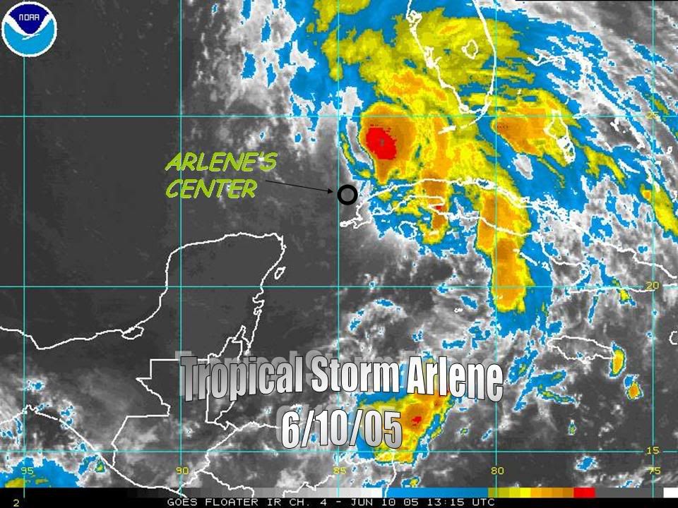
http://i21.photobucket.com/albums/b300/ ... ARLENE.jpg
Just to show how separated was Arlene's center to the convection and it was still a tropical storm.
Just to show how separated was Arlene's center to the convection and it was still a tropical storm.
0 likes
-
skysummit

- S2K Supporter

- Posts: 5305
- Age: 50
- Joined: Tue Aug 31, 2004 11:09 pm
- Location: Ponchatoula, LA
- Contact:
ALhurricane wrote:skysummit wrote:ALhurricane wrote:The NHC did state there were several small circulations rotating around a mean center. However, looking at visibile satellite, the one moving WSW toward Cozumel is certainly the most impressive looking LLC. There are other small LLCs to the north, although they appear to have lost some definition late this morning. In other words, TD1 is a complete and utter mess.
If the LLC near Cozumel is the dominant feature, then it better get some convection quick. Otherwise, it is game, set, match.
That is where RECON becomes so critical. I don't envy their job of fixing the position of this thing.
AL...what do you think about the circ east of Belize?
I am not sure I see one there. I do see several outflow boundaries coming out of that convection. That means air is divergent at the surface. For development of low pressure, you would want to see air converging in the low levels. I don't think that is where a true circulation is or would establish itself.
Ok, thanks. It just looked like an LLC forming on visible due east of the Mexican/Belize border.
0 likes
-
JamesFromMaine2

- Category 4

- Posts: 989
- Joined: Tue Jul 19, 2005 1:38 am
- Location: Portland Maine USA
- Contact:
ALhurricane wrote:skysummit wrote:ALhurricane wrote:The NHC did state there were several small circulations rotating around a mean center. However, looking at visibile satellite, the one moving WSW toward Cozumel is certainly the most impressive looking LLC. There are other small LLCs to the north, although they appear to have lost some definition late this morning. In other words, TD1 is a complete and utter mess.
If the LLC near Cozumel is the dominant feature, then it better get some convection quick. Otherwise, it is game, set, match.
That is where RECON becomes so critical. I don't envy their job of fixing the position of this thing.
AL...what do you think about the circ east of Belize?
I am not sure I see one there. I do see several outflow boundaries coming out of that convection. That means air is divergent at the surface. For development of low pressure, you would want to see air converging in the low levels. I don't think that is where a true circulation is or would establish itself.
That area this morning reported the lowest pressure at 8am this morning it had a pressure of 1000mb
0 likes
-
CHRISTY
Average Forecast Error...
https://secure.fwhn.com/hurricanealley_ ... 48c3fl.jpg
*edited by staff to make clickable link due to size of image
https://secure.fwhn.com/hurricanealley_ ... 48c3fl.jpg
*edited by staff to make clickable link due to size of image
0 likes
-
ALhurricane
- Professional-Met
- Posts: 452
- Joined: Wed Jan 08, 2003 12:46 pm
- Location: Daphne, AL
JamesFromMaine2 wrote:ALhurricane wrote:skysummit wrote:ALhurricane wrote:The NHC did state there were several small circulations rotating around a mean center. However, looking at visibile satellite, the one moving WSW toward Cozumel is certainly the most impressive looking LLC. There are other small LLCs to the north, although they appear to have lost some definition late this morning. In other words, TD1 is a complete and utter mess.
If the LLC near Cozumel is the dominant feature, then it better get some convection quick. Otherwise, it is game, set, match.
That is where RECON becomes so critical. I don't envy their job of fixing the position of this thing.
AL...what do you think about the circ east of Belize?
I am not sure I see one there. I do see several outflow boundaries coming out of that convection. That means air is divergent at the surface. For development of low pressure, you would want to see air converging in the low levels. I don't think that is where a true circulation is or would establish itself.
That area this morning reported the lowest pressure at 8am this morning it had a pressure of 1000mb
With it spitting out those outflow boundaries it probably won't have the lowest pressure for long. Outflow bounadries are the last thing you want to see if you want to see tropical development.
0 likes
-
GalvestonDuck
- Category 5

- Posts: 15941
- Age: 57
- Joined: Fri Oct 11, 2002 8:11 am
- Location: Galveston, oh Galveston (And yeah, it's a barrier island. Wanna make something of it?)
Jim Hughes wrote:The space weather effect has showed it's relationship here again. Everything that I have continually talked about was in place and TD1 forms. I am not to sure how many more times this needs to occur before the meteorological community wakes up.
It appears to me they're all awake. Otherewise, this puppy would be called TD1 now. Earth weather...tropical weather...that's what is in place for this to happen.
0 likes

Here's why the storm is having a tough time getting its act together - dry air
http://www.ssd.noaa.gov/goes/east/watl/loop-wv.html
http://www.ssd.noaa.gov/goes/east/watl/loop-wv.html
0 likes
-
curtadams
- S2K Supporter
- Posts: 1122
- Joined: Sun Aug 28, 2005 7:57 pm
- Location: Orange, California
- Contact:
skysummit wrote:curtadams wrote:None of the little swirls are the real circulation. Here's a quicksat of LL winds (thanks rockyman):
http://tinyurl.com/f7wzm
All these little swirls are orbiting the big circulation. The big circulation has no convection, I suspect because it's got too much dry air. #1 was putting up a convective smoke trail which died when it got close.
That QuikScat is over 5 hours old.
A circ that big doesn't go away in 5 hours. And you can still see it on the West Atlantic RGB map in the low clouds. (turn off the first five frames for clarity) Circ #1 is still orbiting it, although it's getting close to the center.
0 likes
-
Stratosphere747
- Category 5
- Posts: 3772
- Joined: Thu Sep 11, 2003 8:34 pm
- Location: Surfside Beach/Freeport Tx
- Contact:
-
Jim Hughes
- Category 3
- Posts: 825
- Joined: Sun Jul 24, 2005 1:52 pm
- Location: Martinsburg West Virginia
GalvestonDuck wrote:
It appears to me they're all awake. Otherewise, this puppy would be called TD1 now. Earth weather...tropical weather...that's what is in place for this to happen.
I am not to sure what you men here GD? If your referring to the reasoning being favorable meteorological conditions then I would somewhat agree.
But what you are failing to understand here is that these conditions get put into place by favorable space weather changes.
0 likes
-
CHRISTY
all the convection is the east....i think its begining to feel some sort of push maybe to the NNE?
http://www.ssd.noaa.gov/goes/flt/t1/rb-l.jpg
*edited by staff to make clickable link due to size of image
http://www.ssd.noaa.gov/goes/flt/t1/rb-l.jpg
*edited by staff to make clickable link due to size of image
0 likes
-
WindRunner

- Category 5
- Posts: 5803
- Age: 35
- Joined: Fri Jul 29, 2005 8:07 pm
- Location: Warrenton, VA, but Albany, NY for school
- Contact:
I don't know if anyone has posted this, but a ship just north of the circulation center has been reporting increasing winds all morning. Ship KS049 reported last hour a 39kt wind and pressure of 1000.9 mb at 11:42 EDT. Certainly possible that these readings are miscalibrated, but it's also possible that they aren't.
0 likes
-
wx247

- S2K Supporter
- Posts: 14279
- Age: 42
- Joined: Wed Feb 05, 2003 10:35 pm
- Location: Monett, Missouri
- Contact:
This system is NOT moving NE right now.
0 likes
Personal Forecast Disclaimer:
The posts in this forum are NOT official forecast and should not be used as such. They are just the opinion of the poster and may or may not be backed by sound meteorological data. They are NOT endorsed by any professional institution or storm2k.org. For official information, please refer to the NHC and NWS products.
The posts in this forum are NOT official forecast and should not be used as such. They are just the opinion of the poster and may or may not be backed by sound meteorological data. They are NOT endorsed by any professional institution or storm2k.org. For official information, please refer to the NHC and NWS products.

-
CHRISTY
NHC MODELS...
https://secure.fwhn.com/hurricanealley_ ... 5828fl.jpg
INTERMEDIATE MODELS....DIFFERENT AGENCIES
https://secure.fwhn.com/hurricanealley_ ... c3f8fl.jpg
SPAGHETTI MODELS...
https://secure.fwhn.com/hurricanealley_ ... fbd4fl.jpg
*edited by staff to make clickable links due to size of images
*please stop posting such large images
Last edited by CHRISTY on Sat Jun 10, 2006 12:06 pm, edited 1 time in total.
0 likes

>>Just to show how separated was Arlene's center to the convection and it was still a tropical storm.
LMAO HURAKAN. How many people can you recall swearing that the center was under the highest cloudtops too? That's terminal on this site - that and the center is going to reform closer to the deepest convetion. I swear. It really will. It's coming to my house!
/sorry for the threadjack, but that picture was a great illustration of what I was talking about earlier with the IR sats that some people try to base their reasoning off of.
LMAO HURAKAN. How many people can you recall swearing that the center was under the highest cloudtops too?
/sorry for the threadjack, but that picture was a great illustration of what I was talking about earlier with the IR sats that some people try to base their reasoning off of.
0 likes
-
Weatherfreak000
Who is online
Users browsing this forum: No registered users and 7 guests