when I was stationed in the Philippines, Typhoon Violet became the first April typhoon to hit northern Luzon in something like 20 years or so and at 125kt it was also the strongest April typhoon there. The track looks like this could be a repeat of that event which is very rare since, as I've said before, most April Typhoons that hit the Philippines usually got through the Visayas. Curiously, we are continuing the trend of early season strong typhoons though this one is about a month later than last years first super which occurred in early March.
Steve
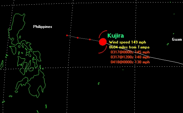
Typhoon Kujira is slowly weakening
Moderator: S2k Moderators
-
Aslkahuna

- Professional-Met

- Posts: 4549
- Joined: Thu Feb 06, 2003 5:00 pm
- Location: Tucson, AZ
- Contact:
In April, 1967
0 likes


-
cycloneye

- Admin

- Posts: 149720
- Age: 69
- Joined: Thu Oct 10, 2002 10:54 am
- Location: San Juan, Puerto Rico
It is moving westnorthwest and away from Guam so now it is moving on open waters but the Philliphines is on the track of what is now a powerful typhoon that has 125kts but not a supertyphoon yet.
0 likes
Visit the Caribbean-Central America Weather Thread where you can find at first post web cams,radars
and observations from Caribbean basin members Click Here
and observations from Caribbean basin members Click Here
-
Anonymous
The official track forecast for Kujira is continuing to shift further south. A strike on the Phillipines, as TWW has been calling for, is an almost certainty. A little bit of good news is that it now looks like the storm will be gradually weaken before it approaches (after it peaks, which it has yet to do). How much it weakens before it hits is still an open question at this point.
0 likes
-
cycloneye
- Admin
- Posts: 149720
- Age: 69
- Joined: Thu Oct 10, 2002 10:54 am
- Location: San Juan, Puerto Rico
It is now a supertyphoon with 130kts winds and higher gusts to 160 kts but now the Philliphines are at the track of it but will it weaken some before it makes landfall somewhere in that countrie?
In those sat pics it looks really a true powerful system with that eye that is a perfect one.
0 likes
Visit the Caribbean-Central America Weather Thread where you can find at first post web cams,radars
and observations from Caribbean basin members Click Here
and observations from Caribbean basin members Click Here
-
Aslkahuna
- Professional-Met
- Posts: 4549
- Joined: Thu Feb 06, 2003 5:00 pm
- Location: Tucson, AZ
- Contact:
Some Weakening
will occur before the storm reaches the Philippines as the airmass over the Philippines in April is Trade Air rather than deep mT air. There is usually a pretty healthy subsidence inversion around H7 or so with dry air above additionally, we still usually have remnants of the NE Monsoon over the SCS with cooler and dryer air that can be pulled across the islands into the storm as it approaches. This is a very unusual track for an April storm to be sure.
Steve
Steve
0 likes
-
cycloneye
- Admin
- Posts: 149720
- Age: 69
- Joined: Thu Oct 10, 2002 10:54 am
- Location: San Juan, Puerto Rico
Here is full disk of western pacific look at supertyphoon
http://www.nrlmry.navy.mil/sat-bin/disp ... C_SCALE=15
The Philliphines are to the left of the supertyphoon on that pic.Hope you are right Steve about the subsidence because it would be a catastrofy if it goes there at this strengh.
The Philliphines are to the left of the supertyphoon on that pic.Hope you are right Steve about the subsidence because it would be a catastrofy if it goes there at this strengh.
0 likes
Visit the Caribbean-Central America Weather Thread where you can find at first post web cams,radars
and observations from Caribbean basin members Click Here
and observations from Caribbean basin members Click Here
-
cycloneye
- Admin
- Posts: 149720
- Age: 69
- Joined: Thu Oct 10, 2002 10:54 am
- Location: San Juan, Puerto Rico
Kujira has peaked in intensitie
http://www.npmoc.navy.mil/jtwc/satshots/wp0203savs.jpg
Now from here Kujira will begin slowly to weaken but the 2 questions are will it weaken big time and if the track will send it to Luzon or it will deviate and not affect the Phillippines.The sat pics show that the system is not as simetric as in the past 2 days and the eye is not perfect as before and that may indicate that dry air may be beggining to affect it.
Now from here Kujira will begin slowly to weaken but the 2 questions are will it weaken big time and if the track will send it to Luzon or it will deviate and not affect the Phillippines.The sat pics show that the system is not as simetric as in the past 2 days and the eye is not perfect as before and that may indicate that dry air may be beggining to affect it.
0 likes
Visit the Caribbean-Central America Weather Thread where you can find at first post web cams,radars
and observations from Caribbean basin members Click Here
and observations from Caribbean basin members Click Here
-
mf_dolphin

- Category 5

- Posts: 17758
- Age: 69
- Joined: Tue Oct 08, 2002 2:05 pm
- Location: St Petersburg, FL
- Contact:
-
cycloneye
- Admin
- Posts: 149720
- Age: 69
- Joined: Thu Oct 10, 2002 10:54 am
- Location: San Juan, Puerto Rico
Good news that Kujira is no longer a supertyphoon as it has continued to weaken with dry air that has penetrated the system and the simetrie of it is not the same as the past 2 days.
0 likes
Visit the Caribbean-Central America Weather Thread where you can find at first post web cams,radars
and observations from Caribbean basin members Click Here
and observations from Caribbean basin members Click Here
-
Aslkahuna
- Professional-Met
- Posts: 4549
- Joined: Thu Feb 06, 2003 5:00 pm
- Location: Tucson, AZ
- Contact:
That's The Dry Air
that I mentioned in my discussion of the climatology of April Typhoons in the Philippines. If you were to look at an April Sounding from Clark AB it would not look very tropical being quite dry in the mean even though low level moisture would be present. The latest from JT has the storm approaching 18N well east of Luzon on a 330 degree heading. A storm on that kind of track will not hit Luzon and at any rate the storm would not be a typhoon if it did.
Steve
Steve
0 likes
-
cycloneye
- Admin
- Posts: 149720
- Age: 69
- Joined: Thu Oct 10, 2002 10:54 am
- Location: San Juan, Puerto Rico
Steve Luzon apparently will be safe from what will be left of the weakening system as the forecast track has shifted more to the north so good news for them.
0 likes
Visit the Caribbean-Central America Weather Thread where you can find at first post web cams,radars
and observations from Caribbean basin members Click Here
and observations from Caribbean basin members Click Here
Who is online
Users browsing this forum: No registered users and 40 guests