ScottNAtlanta wrote:Ok...bedtime...either I will wake up to a surprise Hurricane or tilt-a-whirl storm that ain't stacked

Tilt-a-Whirl it is apparently
Moderator: S2k Moderators


ScottNAtlanta wrote:Ok...bedtime...either I will wake up to a surprise Hurricane or tilt-a-whirl storm that ain't stacked


ScottNAtlanta wrote:I'm surprised even with the synoptic data that NOAA got last night the EURO hasn't budged. They had a lot of new data that made it into the latest runs.

Dean4Storms wrote:I don’t get all the trust on this storm with the ECM when a couple days ago it had this storm up near Jamaica crossing just west of central Cuba and heading for the very tip of South Florida. The GFS on the other hand had it right about where it’s at now. I know that could change but the GFS has performed well with this storm so far as far as track is concerned. It’s also different with the westerlies getting involved in a couple days, but until the ECM proves itself I am leaning toward the GFS camp with track.
johngaltfla wrote:toad strangler wrote:If I lived in a truly flood prone area out there, I wouldn’t need the government to tell me when to go. I’d be out of there already.
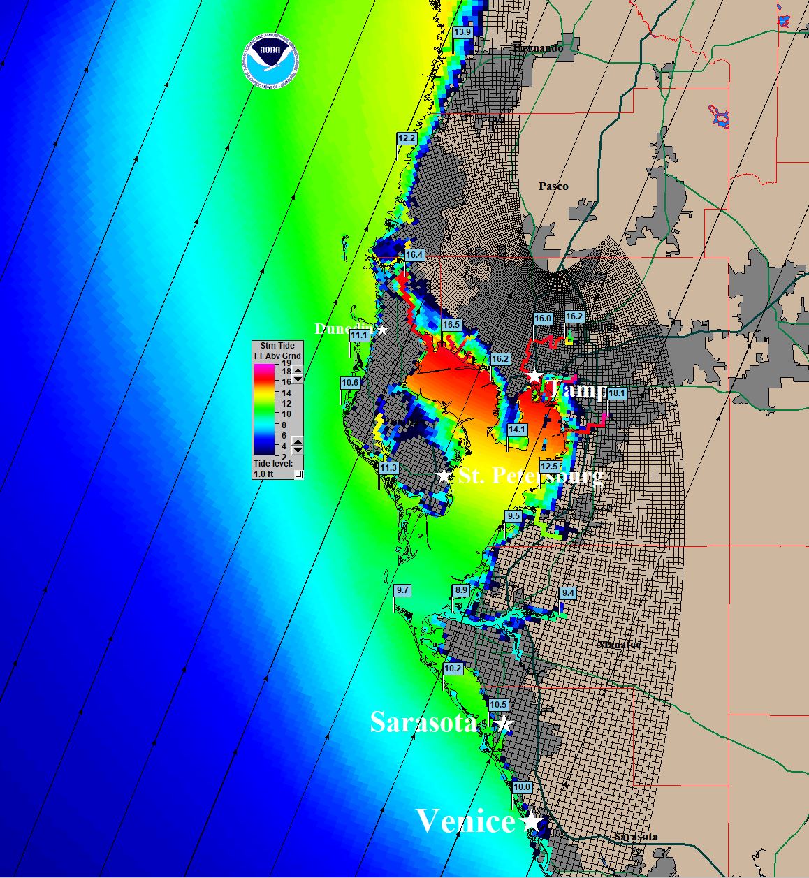
You have to understand the mindset over here because the Gulf coast here rarely gets a major hit. A lot of the people think that storm surge only impacts beachfront property. What they do not understand is that a Cat 3-4 slowing into the Bay area is the nightmare scenario for flooding when adding 15" plus of rain on top of it. This area is already saturated so more rain is only going to make things a lot worse in those neighborhoods which tend to flood.


LARanger wrote:johngaltfla wrote:toad strangler wrote:If I lived in a truly flood prone area out there, I wouldn’t need the government to tell me when to go. I’d be out of there already.
You have to understand the mindset over here because the Gulf coast here rarely gets a major hit. A lot of the people think that storm surge only impacts beachfront property. What they do not understand is that a Cat 3-4 slowing into the Bay area is the nightmare scenario for flooding when adding 15" plus of rain on top of it. This area is already saturated so more rain is only going to make things a lot worse in those neighborhoods which tend to flood.
Even that last "tend to flood" is a dangerous presumption. The 2016 Louisiana flooding, caused by what was basically a stationary inland hurricane, dropped around 7 trillion gallons on around a third of the state. That was up to 30"+ of rain in places over an area large enough to cover (and defeat) river systems, leaving folks that had barely ever seen so much as an overtopped ditch with water lapping at the ceiling. A year later, Harvey doubled the Louisiana 2016 event in size and intensity, doubling or tripling the total rainfall volume (though you can find some wilder estimates from the time suggesting as high as 33 trillion gallons), and resulting in literally five feet of rain in places. That's sufficient to not just defeat river systems, but basically to defeat drainage *as a concept*.


chris_fit wrote:Yes or No - If you were Tampa Area (Bradenton) - Would you be shuttering up?
My plan is to wait until this afternoon models, if E shift in most guidance, shutter up - otherwise no. Wise plan?
Weatherboy1 wrote:Jr0d wrote:Going to rely on points and how far Ian is away from those points now until until north of Key West to get an idea of how much of an impact we will likely experience.
First point was 15n 80w,(missed just right). Next point for me is 17N 81W, if it hits or misses right we can expect more of an impact, NHC official forecast is left of that point).
Ian appears to be moving NW now and not forecast to move due north until it clears Cuba, obviously if it turns NNW then N before Cuba, this is bad for me and the peninsula. As we know, the further south at land fall the stronger the storm will be.
Not a forecast by any means, but I am NOT expecting a panhandle landfall. My best guess is Fort Myers to Cedar Key. The angle of the storm.vs coastline make it impossible to narrow it down.
While obviously a much different set up, Charley hooking
right earlier than expected and strengthening comes to mind as a bad outlier
My strong belief based on what I’m seeing out there is that IF Ian tracks in a direction out of line with the official forecast, it’ll be to the south and East not north and west. In other words, I think the chance is higher Ian landfalls south of, say, Tampa than well north
ScottNAtlanta wrote:I'm surprised even with the synoptic data that NOAA got last night the EURO hasn't budged. They had a lot of new data that made it into the latest runs.

cane5 wrote:Weatherboy1 wrote:Jr0d wrote:Going to rely on points and how far Ian is away from those points now until until north of Key West to get an idea of how much of an impact we will likely experience.
First point was 15n 80w,(missed just right). Next point for me is 17N 81W, if it hits or misses right we can expect more of an impact, NHC official forecast is left of that point).
Ian appears to be moving NW now and not forecast to move due north until it clears Cuba, obviously if it turns NNW then N before Cuba, this is bad for me and the peninsula. As we know, the further south at land fall the stronger the storm will be.
Not a forecast by any means, but I am NOT expecting a panhandle landfall. My best guess is Fort Myers to Cedar Key. The angle of the storm.vs coastline make it impossible to narrow it down.
While obviously a much different set up, Charley hooking
right earlier than expected and strengthening comes to mind as a bad outlier
My strong belief based on what I’m seeing out there is that IF Ian tracks in a direction out of line with the official forecast, it’ll be to the south and East not north and west. In other words, I think the chance is higher Ian landfalls south of, say, Tampa than well north
That’s a bold prediction based on what ?
CronkPSU wrote:ScottNAtlanta wrote:I'm surprised even with the synoptic data that NOAA got last night the EURO hasn't budged. They had a lot of new data that made it into the latest runs.
Could say the same thing about the GFS refusing to budge with the new data, one would think ONE of them would have budged but nope
Hypercane_Kyle wrote:ScottNAtlanta wrote:I'm surprised even with the synoptic data that NOAA got last night the EURO hasn't budged. They had a lot of new data that made it into the latest runs.
Euro probably has the right thinking with gradual intensification. I am not if/how this correlates to a more eastern track.
Jr0d wrote:Weatherboy1 wrote:
My strong belief based on what I’m seeing out there is that IF Ian tracks in a direction out of line with the official forecast, it’ll be to the south and East not north and west. In other words, I think the chance is higher Ian landfalls south of, say, Tampa than well north
For sure!
I am currently limited by my cognitive "location" bias that is preventing me from seeing this clearly. I will subconsciously make assumptions or see things that bring Ian closer To Key West. Having those hit it miss points help me a little.
If I were to place bets for a landfall, it would be Tarpon Springs, with Ian hitting south being much more likely than missing north.

jlauderdal wrote:[
At a minimum, you should get a surge to deal with in KW. The problem with a storm like this is a few hours of wobble to the east and you have a power outage. We had a situation in sofla mid 2000's where we were hit with one big gust from a feeder band that knocked out power to 250,000 customers. Otherwise, it was sunny and we had less than an inch of rain from a gulf system.

Users browsing this forum: No registered users and 56 guests


