The LLC about to leave the Florida Panhandle for Alabama is still quite obvious. Until it dies organizing a new LLC closer to the storms is unlikely. This making a run at a TD before Louisiana landfall is the ceiling for this. I absolutely understand why NHC cancelled the recon this afternoon but it would have been nice for aircraft data to be in the 0Z models.
Edit to add: Outflow boundaries (a sign of dry air) coming from the most intense offshore convection is also a negative signal for those expecting a new LLC soon.
ATL: INVEST 93L - Discussion
Moderators: hurricanetrack, S2k Moderators

The posts in this forum are NOT official forecasts and should not be used as such. They are just the opinion of the poster and may or may not be backed by sound meteorological data. They are NOT endorsed by any professional institution or STORM2K. For official information, please refer to products from the National Hurricane Center and National Weather Service.

-
TomballEd
- Category 2

- Posts: 690
- Age: 61
- Joined: Wed Aug 16, 2023 4:52 pm
- Location: Spring/Klein area, not Tomball
Re: ATL: INVEST 93L - Discussion
2 likes
Re: ATL: INVEST 93L - Discussion
This thread is over if the area Southwest of PCB doesn't form before Louisiana:
1 likes

Re: ATL: INVEST 93L - Discussion
Looking better: towers refiring in just about the same location.
2 likes
Re: ATL: INVEST 93L - Discussion
Anti-cyclone is pretty much over the top of the convection now.
Watching if this goes ballistic around dusk.
Watching if this goes ballistic around dusk.
2 likes
-
Frank P
- S2K Supporter

- Posts: 2775
- Joined: Fri Aug 29, 2003 10:52 am
- Location: Biloxi Beach, Ms
- Contact:
Re: ATL: INVEST 93L - Discussion
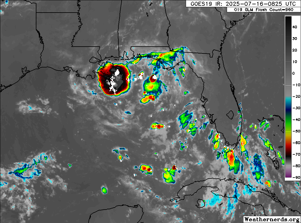
GCANE wrote:Radar indicating some rotation of the towers
Premature speculation on my part but might be the general area of the rotating HT where the lightning strikes are evident?

1 likes
Re: ATL: INVEST 93L - Discussion
Frank P wrote:GCANE wrote:Radar indicating some rotation of the towers
Premature speculation on my part but might be the general area of the rotating HT where the lightning strikes are evident?
https://i.ibb.co/Y4kmgZL2/IMG-5360.jpg
Spot on
0 likes
Re: ATL: INVEST 93L - Discussion
BobHarlem wrote:Doesn't look like much will happen today with it, maybe as it gets closer to Louisiana. All the models keeping it in the general area and looping it back into the gulf in a week or so are wild though. And that keys thing is still there.
https://i.postimg.cc/gcvqQb2N/83073179.gif
There was some vicious lightning this AM in South Florida from that keys thing.
Last edited by Nuno on Wed Jul 16, 2025 12:31 pm, edited 1 time in total.
1 likes
Andrew (1992), Irene (1999), Frances (2004), Katrina (2005), Wilma (2005), Fay (2008), Irma (2017), Eta (2020), Ian (2022)
Re: ATL: INVEST 93L - Discussion
This may be pushed to the southwest and IMHO there is a chance it could miss the MS Delta.
0 likes
-
cycloneye

- Admin

- Posts: 145277
- Age: 68
- Joined: Thu Oct 10, 2002 10:54 am
- Location: San Juan, Puerto Rico
Re: ATL: INVEST 93L - Discussion
Tropical Weather Outlook
NWS National Hurricane Center Miami FL
200 PM EDT Wed Jul 16 2025
For the North Atlantic...Caribbean Sea and the Gulf of America:
Northeastern and north-central Gulf (AL93):
Surface and radar observations indicate that a westward-moving
broad area of low pressure is located along the coast of the
Florida Panhandle near Panama City. The associated shower and
thunderstorm activity remains disorganized and located mainly south
and southwest of the center. This system is forecast to continue
moving westward across the northern portion of the Gulf through
tonight, reaching the coast of Louisiana by Thursday. If this system
moves far enough offshore, environmental conditions over the Gulf
appear generally favorable for additional development, and a
tropical depression could form over the next day or two before
the system moves fully inland by the end of the week.
Regardless of development, heavy rainfall could produce localized
flash flooding over portions of Florida through through today.
Heavy rainfall could also cause flash flooding for portions of the
north-central Gulf Coast beginning late today and continuing through
Friday. For additional information, please refer to products issued
by the Weather Prediction Center and your local National Weather
Service office.
* Formation chance through 48 hours...medium...40 percent.
* Formation chance through 7 days...medium...40 percent.
$$
Forecaster Beven
1 likes
Visit the Caribbean-Central America Weather Thread where you can find at first post web cams,radars
and observations from Caribbean basin members Click Here
and observations from Caribbean basin members Click Here
-
wxman57

- Moderator-Pro Met

- Posts: 22977
- Age: 67
- Joined: Sat Jun 21, 2003 8:06 pm
- Location: Houston, TX (southwest)
Re: ATL: INVEST 93L - Discussion
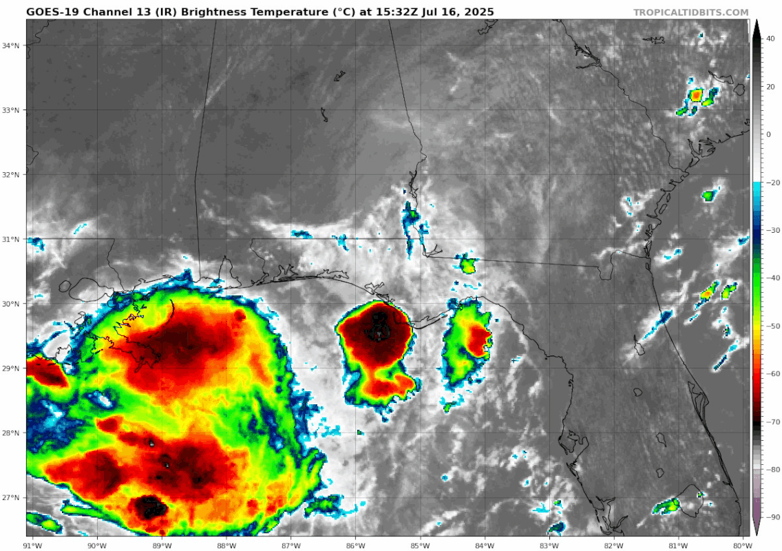
LLC over Florida is definitely weakening, but I see no sign of something spinning up offshore. Convection near the LA Delta is weakening, as is evident by the outflow boundaries. Small blob south of Pensacola isn't doing much, but that would be the place to watch for center redevelopment. However, it's only about 175 miles from reaching SE LA, so there is not much time left. I think it's unlikely to become a depression before tomorrow morning when it moves inland. Good news is that GFS develops another similar situation next Monday! Yeah, right...
2 likes
-
TomballEd
- Category 2
- Posts: 690
- Age: 61
- Joined: Wed Aug 16, 2023 4:52 pm
- Location: Spring/Klein area, not Tomball
Re: ATL: INVEST 93L - Discussion
I think there is enough of the LLC left just inland that one small blob of convection won't be able to generate a new LLC anytime soon and as mentioned, time is running out. Even a new LLC forming under the tiny blob isn't missing Louisiana.
1 likes
-
USTropics
- Professional-Met

- Posts: 2649
- Joined: Sun Aug 12, 2007 3:45 am
- Location: Florida State University
Re: ATL: INVEST 93L - Discussion
TomballEd wrote:I think there is enough of the LLC left just inland that one small blob of convection won't be able to generate a new LLC anytime soon and as mentioned, time is running out. Even a new LLC forming under the tiny blob isn't missing Louisiana.
I'd agree, it's the current LLC over land or nothing with this system. Here is the 12z ECMWF going back two days ago. This is a cool product where areas shaded in green indicate cyclonic vorticity at 850mb, while purple areas are typically associated with fronts. We can see the ECMWF tracks the LLC the entire time up to the coast of LA tomorrow morning around ~8AM ET:

Looking at the 12z HAFS-B, around midnight ET would be the earliest we would see the LLC remerge over the GOM:

imo this will be another scenario where invest 93L will be the most organized right at landfall tomorrow morning. Enough to be classified as a tropical cyclone? I would say no, but the end result doesn't really matter (mild gusts and rain being the main impact).
2 likes
-
TallyTracker
- Category 2
- Posts: 734
- Joined: Thu Oct 11, 2018 2:46 pm
Re: ATL: INVEST 93L - Discussion
The rain has been training over Tallahassee all day on the east side of the LLC. We’ve gotten a few inches of rain with some gusty winds in squalls. I think that will be the main thing with this system. Fortunately it was hot and dry before this so flooding should be minor in the Panhandle.
I’d put development odds at 10-20% at this point though the NHC may wait to lower it to keep the focus on the flood threat. The LLC has been persistent and does not seem to be dissipating. As others have noted, unless it redevelops under the new blob off PCB, it’s not developing.
I’d put development odds at 10-20% at this point though the NHC may wait to lower it to keep the focus on the flood threat. The LLC has been persistent and does not seem to be dissipating. As others have noted, unless it redevelops under the new blob off PCB, it’s not developing.
1 likes
Fran '96, Georges '98, Gordon '00, Gabrielle '01, Charley '04, Frances '04, Jeanne '04, Barry '07, Fay '08, Debby '12, Matthew '16, Emily '17, Irma '17, Michael ‘18, Elsa ‘21, Fred ‘21, Mindy ‘21, Nicole ‘22, Idalia ‘23, Debby ‘24, Helene ‘24
-
jaguars_22
- Category 2
- Posts: 590
- Joined: Tue Jun 20, 2017 2:26 pm
- Location: Victoria TX
-
LadyBug72

- Tropical Storm

- Posts: 118
- Joined: Mon Jun 01, 2020 3:39 pm
- Location: about 20 miles from Galveston, Tx
Re: ATL: INVEST 93L - Discussion
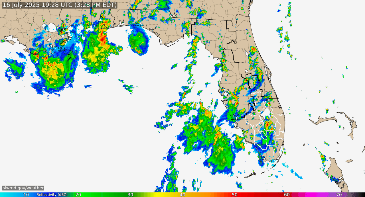
jaguars_22 wrote:Anyone notice the twisting in the blob below New Orleans?
Can you please share radar?
0 likes
Formerly known as the user: Nikki
Alicia 83, Allison 01, Rita 05, Ike 08, Harvey 17, Nicholas 21, Coastal Texas Derecho 24, Beryl 24
Alicia 83, Allison 01, Rita 05, Ike 08, Harvey 17, Nicholas 21, Coastal Texas Derecho 24, Beryl 24
Re: ATL: INVEST 93L - Discussion
LadyBug72 wrote:jaguars_22 wrote:Anyone notice the twisting in the blob below New Orleans?
Can you please share radar?
Afternoon storms are pumping up with the bands well away from where 93L is. The area south of New Orleans is just part of that front convective area. It's starting to look pretty unlikely that 93L develops.
1 likes
-
jaguars_22
- Category 2
- Posts: 590
- Joined: Tue Jun 20, 2017 2:26 pm
- Location: Victoria TX
Re: ATL: INVEST 93L - Discussion
......its dead Jim...
The HRRR model has been showing this deepening heading more towards Texas... according to the satellite view
The HRRR model has been showing this deepening heading more towards Texas... according to the satellite view
2 likes

-
Stratton23
- Category 5

- Posts: 2515
- Joined: Fri Jul 21, 2023 10:59 pm
- Location: Katy, Tx
Re: ATL: INVEST 93L - Discussion
No development this time, to close to land, however 93L may get a 2nd shot at developing down the road in the gulf again, storybook isnt closed on this one yet even if it loses the “ invest “ name
0 likes
Return to “Active Storms/Invests - Atlantic/EastPAC/CentralPAC/MED”
Who is online
Users browsing this forum: No registered users and 11 guests