ATL: INVEST 93L - Discussion

Current storms and invests:

Moderators: hurricanetrack, S2k Moderators


The posts in this forum are NOT official forecasts and should not be used as such. They are just the opinion of the poster and may or may not be backed by sound meteorological data. They are NOT endorsed by any professional institution or STORM2K. For official information, please refer to products from the National Hurricane Center and National Weather Service.

Help Support Storm2K
Message
Author
User avatar
AnnularCane
S2K Supporter
S2K Supporter
Posts: 2862
Joined: Thu Jun 08, 2006 9:18 am
Location: Wytheville, VA

Re: ATL: INVEST 93L - Discussion

#181 Postby AnnularCane » Wed Jul 16, 2025 4:56 pm

Stratton23 wrote:No development this time, to close to land, however 93L may get a 2nd shot at developing down the road in the gulf again, storybook isnt closed on this one yet even if it loses the “ invest “ name


If you fall off the horse, get right back on. :lol:
1 likes   
"But it never rained rain. It never snowed snow. And it never blew just wind. It rained things like soup and juice. It snowed mashed potatoes and green peas. And sometimes the wind blew in storms of hamburgers." -- Judi Barrett, Cloudy with a Chance of Meatballs

User avatar
HurricaneBelle
S2K Supporter
S2K Supporter
Posts: 1179
Joined: Sun Aug 27, 2006 6:12 pm
Location: Clearwater, FL

Re: ATL: INVEST 93L - Discussion

#182 Postby HurricaneBelle » Wed Jul 16, 2025 5:01 pm

this system is putting the "L" in 93L, a lot of rain for a lot of people and not much more
1 likes   

BobHarlem
Category 5
Category 5
Posts: 2102
Joined: Thu Oct 20, 2005 6:11 pm

Re: ATL: INVEST 93L - Discussion

#183 Postby BobHarlem » Wed Jul 16, 2025 5:34 pm

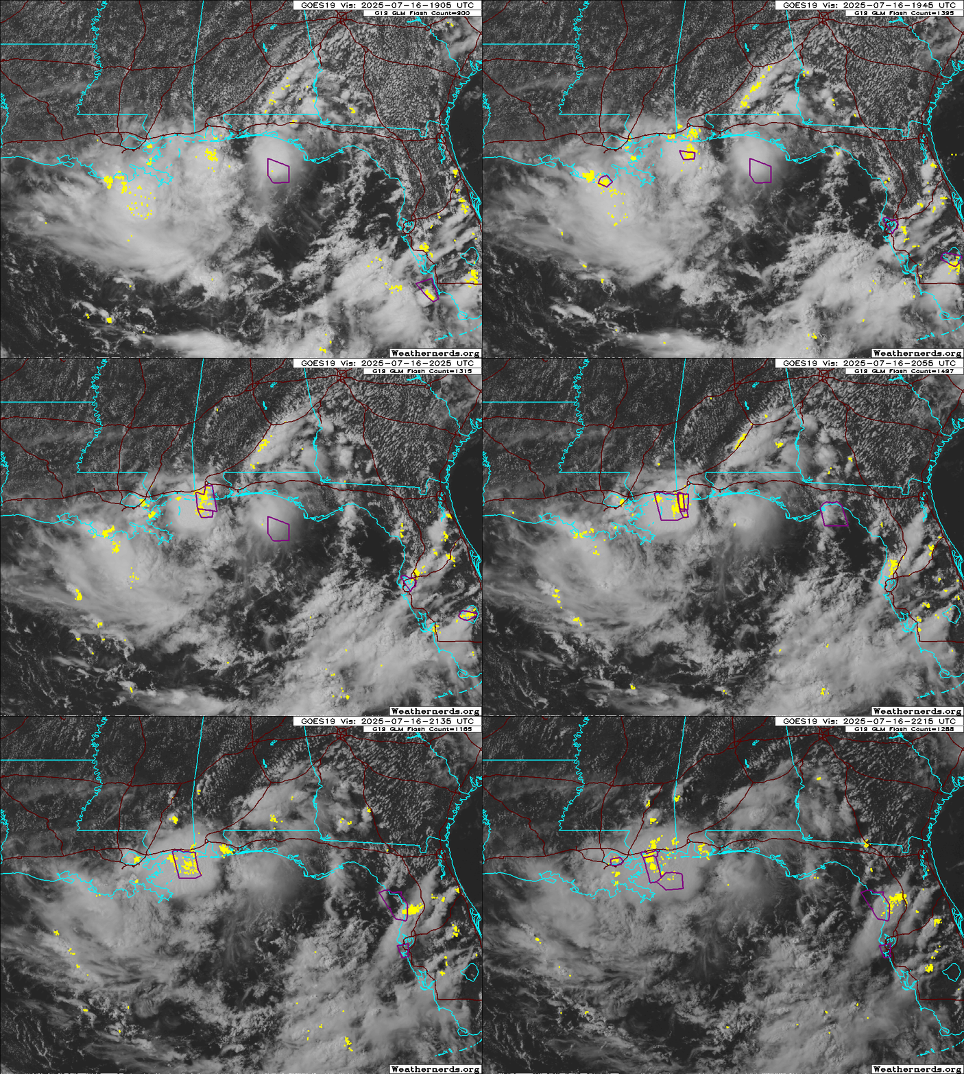
Big convective blowup just east of Louisiana, but not where it needs to develop.
Image
3 likes   

User avatar
MGC
S2K Supporter
S2K Supporter
Posts: 5899
Joined: Sun Mar 23, 2003 9:05 pm
Location: Pass Christian MS, or what is left.

Re: ATL: INVEST 93L - Discussion

#184 Postby MGC » Wed Jul 16, 2025 6:03 pm

Heavy rain and lots of lightning here in Pass Christian currently......MGC
0 likes   

Stormcenter
S2K Supporter
S2K Supporter
Posts: 6684
Joined: Wed Sep 03, 2003 11:27 am
Location: Houston, TX

Re: ATL: INVEST 93L - Discussion

#185 Postby Stormcenter » Wed Jul 16, 2025 6:09 pm

Whatever is south of Biloxi looks suspicious.
0 likes   

Stratton23
Category 5
Category 5
Posts: 2518
Joined: Fri Jul 21, 2023 10:59 pm
Location: Katy, Tx

Re: ATL: INVEST 93L - Discussion

#186 Postby Stratton23 » Wed Jul 16, 2025 6:16 pm

Stormcenter i believe thats an upper level low, non tropical
0 likes   

Frank P
S2K Supporter
S2K Supporter
Posts: 2776
Joined: Fri Aug 29, 2003 10:52 am
Location: Biloxi Beach, Ms
Contact:

Re: ATL: INVEST 93L - Discussion

#187 Postby Frank P » Wed Jul 16, 2025 6:16 pm

Stormcenter wrote:Whatever is south of Biloxi looks suspicious.

I got 3/4 in of rain and wind gusts up to 22 mph out of the south about 45 minutes ago, it’s definitely tropical downpours. Winds have died down now and are only 4 mph out of the SSW.
0 likes   

Javlin
Category 5
Category 5
Posts: 1620
Age: 64
Joined: Fri Jul 09, 2004 7:58 pm
Location: ms gulf coast

Re: ATL: INVEST 93L - Discussion

#188 Postby Javlin » Wed Jul 16, 2025 6:25 pm

Stratton23 wrote:Stormcenter i believe thats an upper level low, non tropical

I think that is the ole MLC now back 100 miles S of Pensacola you see a small tower what I think was the old LLC(?) not that any of us expect much from this point out is just rain...just an obs. :wink:

https://www.tropicaltidbits.com/sat/sat ... product=ir
0 likes   

LarryWx
S2K Supporter
S2K Supporter
Posts: 6301
Joined: Sun Sep 07, 2003 2:04 pm
Location: GA

Re: ATL: INVEST 93L - Discussion

#189 Postby LarryWx » Wed Jul 16, 2025 6:25 pm

Tropical Weather Outlook
NWS National Hurricane Center Miami FL
800 PM EDT Wed Jul 16 2025

For the North Atlantic...Caribbean Sea and the Gulf of America:

1. Northeastern and north-central Gulf (AL93):
Surface and radar observations indicate that a westward-moving broad
area of low pressure continues to be located near the coast of the
western part of the Florida Panhandle. The associated shower and
thunderstorm activity remains disorganized and located south to
southwest of the center. This system is forecast to continue moving
westward across the northern portion of the Gulf tonight, and is
expected to reach the Louisiana coast by Thursday. If this system
moves far enough offshore, environmental conditions over the Gulf
appear generally favorable for additional development, and a
tropical depression could form over the next day or so before the
system moves fully inland by the end of the week.

Regardless of development, heavy rainfall could produce localized
flash flooding over portions of Florida tonight and continuing for
portions of the north-central Gulf Coast through Friday. For
additional information, please refer to products issued by the
Weather Prediction Center and your local National Weather Service
office.
* Formation chance through 48 hours...medium...40 percent.
* Formation chance through 7 days...medium...40 percent.


Forecaster Papin
1 likes   
Personal Forecast Disclaimer:
The posts in this forum are NOT official forecasts and should not be used as such. They are just the opinion of the poster and may or may not be backed by sound meteorological data. They are NOT endorsed by any professional institution or storm2k.org. For official information, please refer to the NHC and NWS products.

BobHarlem
Category 5
Category 5
Posts: 2102
Joined: Thu Oct 20, 2005 6:11 pm

Re: ATL: INVEST 93L - Discussion

#190 Postby BobHarlem » Wed Jul 16, 2025 6:49 pm

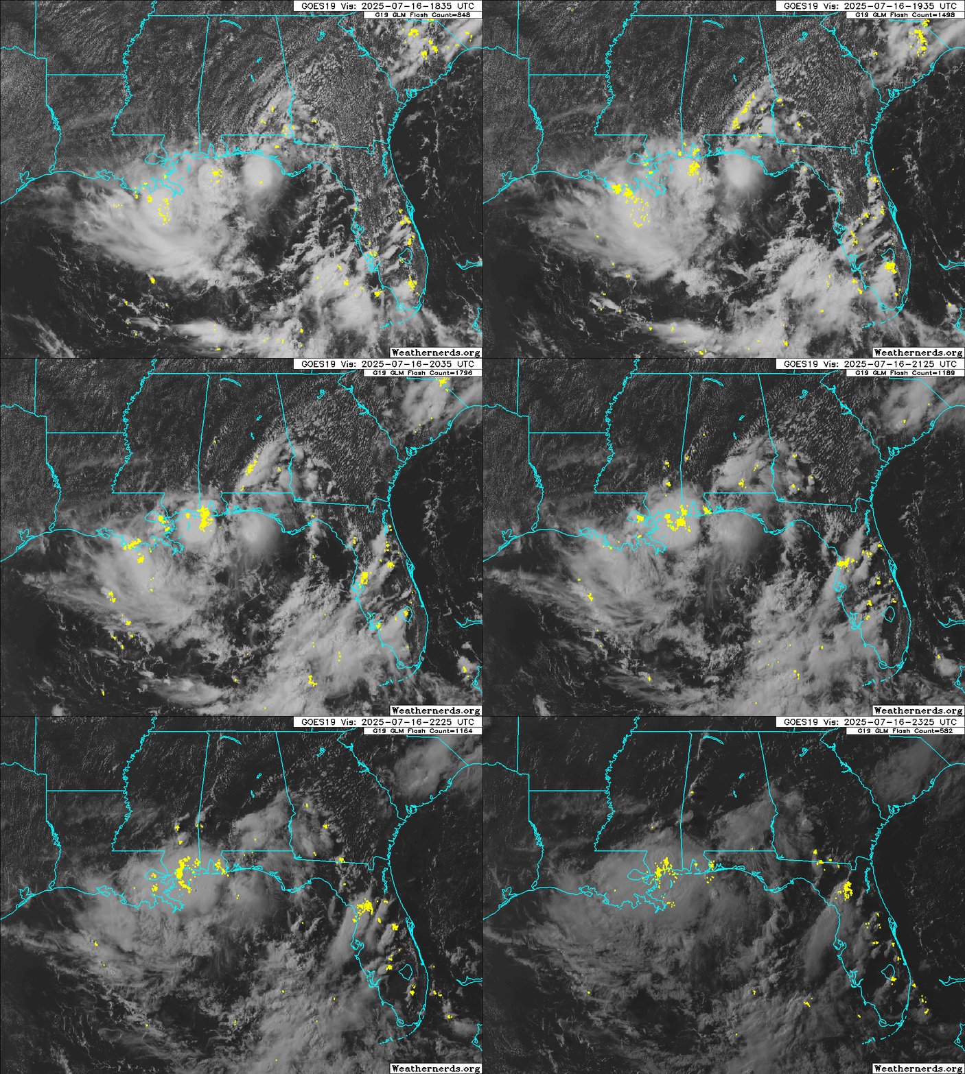
Close to last visibles of the day:

Image
1 likes   

Sciencerocks
Category 5
Category 5
Posts: 9155
Age: 39
Joined: Thu Jul 06, 2017 1:51 am

Re: ATL: INVEST 93L - Discussion

#191 Postby Sciencerocks » Wed Jul 16, 2025 8:02 pm

Probably has a closed LLC and in fact it has had a closed LLC for the past 48 hours or since it was off Florida. One could probably say it is a depression. Probably no more then 25 knts but I've seen 20 knt depression in the 1990's.
2 likes   

User avatar
sasha_B
Tropical Depression
Tropical Depression
Posts: 78
Age: 24
Joined: Sun Jun 30, 2024 4:32 pm
Location: Charleston, SC

Re: ATL: INVEST 93L - Discussion

#192 Postby sasha_B » Wed Jul 16, 2025 8:12 pm

Sciencerocks wrote:Probably has a closed LLC and in fact it has had a closed LLC for the past 48 hours or since it was off Florida. One could probably say it is a depression. Probably no more then 25 knts but I've seen 20 knt depression in the 1990's.

Sustained winds are up to 30 kts and has continued deepening (albeit slowly) according to the 0z best track update. I think that forecaster Papin's remarks in the latest outlook from the NHC - and the fact that they've not lowered TC formation chances at all - suggest that this is a possibility they're considering. If it consolidates it will have little time to strengthen, but not zero.
1 likes   

User avatar
cycloneye
Admin
Admin
Posts: 145282
Age: 68
Joined: Thu Oct 10, 2002 10:54 am
Location: San Juan, Puerto Rico

Re: ATL: INVEST 93L - Discussion

#193 Postby cycloneye » Wed Jul 16, 2025 8:51 pm

1 likes   
Visit the Caribbean-Central America Weather Thread where you can find at first post web cams,radars
and observations from Caribbean basin members Click Here


Return to “Active Storms/Invests - Atlantic/EastPAC/CentralPAC/MED”

Who is online

Users browsing this forum: Google Adsense [Bot], Majestic-12 [Bot] and 7 guests