EPAC: KIKO - Hurricane - Discussion
Moderators: hurricanetrack, S2k Moderators

The posts in this forum are NOT official forecasts and should not be used as such. They are just the opinion of the poster and may or may not be backed by sound meteorological data. They are NOT endorsed by any professional institution or STORM2K. For official information, please refer to products from the National Hurricane Center and National Weather Service.

-
Kingarabian

- S2K Supporter

- Posts: 16146
- Joined: Sat Aug 08, 2009 3:06 am
- Location: Honolulu, Hawaii
-
Kingarabian
- S2K Supporter
- Posts: 16146
- Joined: Sat Aug 08, 2009 3:06 am
- Location: Honolulu, Hawaii
-
Kingarabian
- S2K Supporter
- Posts: 16146
- Joined: Sat Aug 08, 2009 3:06 am
- Location: Honolulu, Hawaii
Re: EPAC: KIKO - Hurricane - Discussion
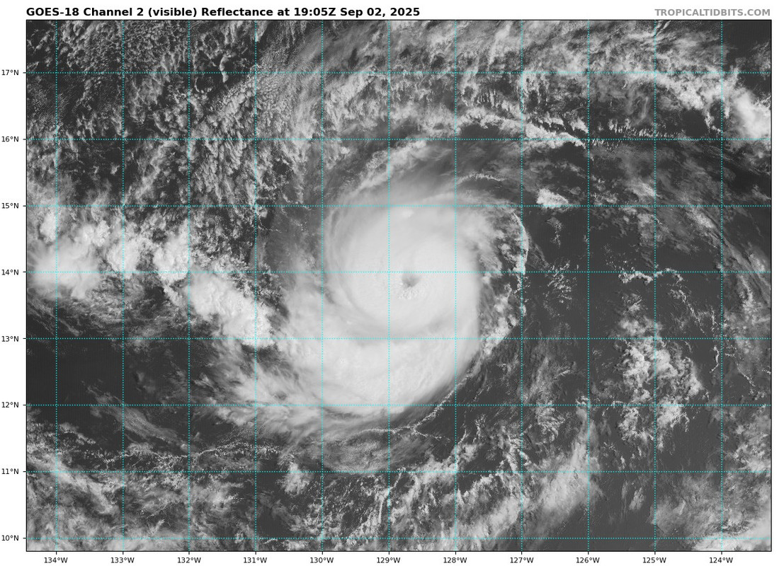
12z EPS and 12z GEFS still show a threat to Hawaii.
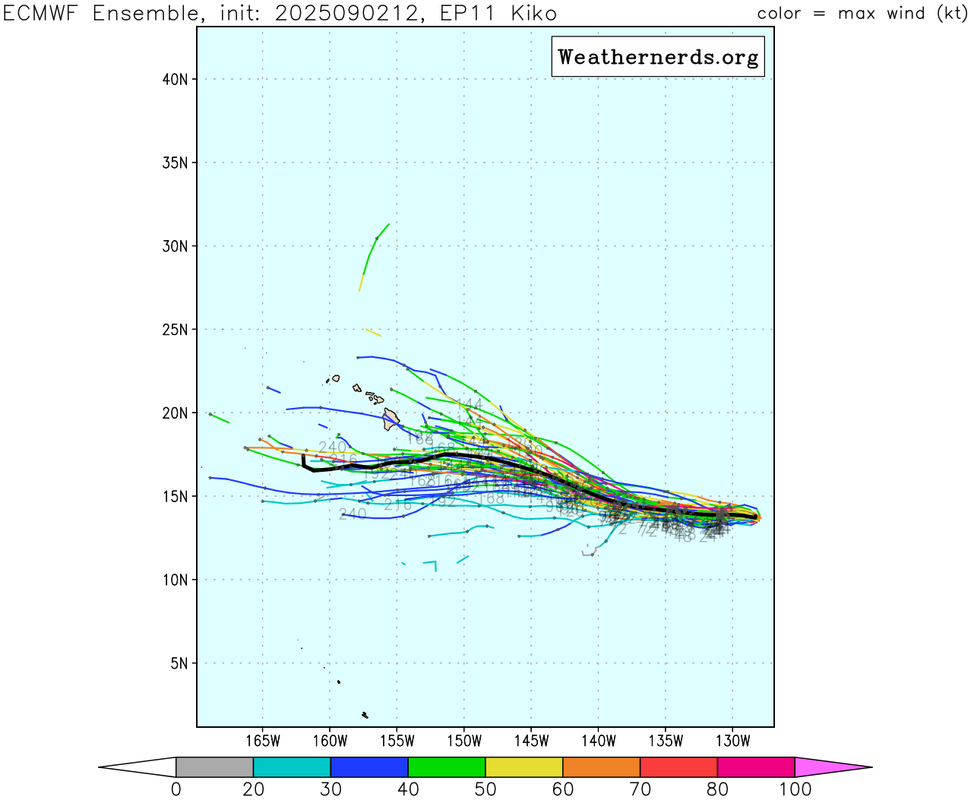
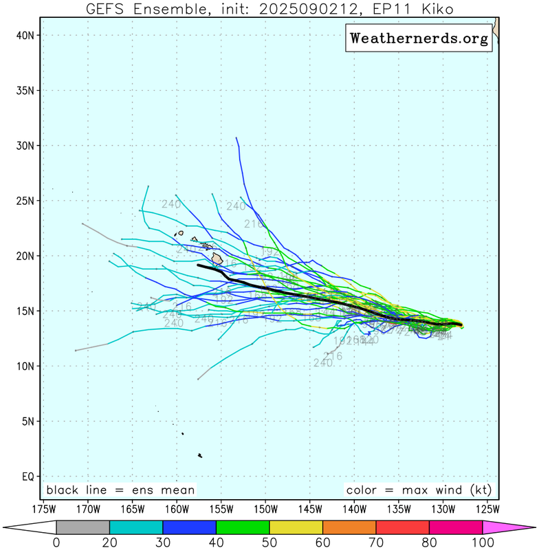
Most members are weak. Kiko is strengthening quicker than what the models are forcasting. So that may alter the track or allow it to be a bigger threat.
Most members are weak. Kiko is strengthening quicker than what the models are forcasting. So that may alter the track or allow it to be a bigger threat.
0 likes
RIP Kobe Bryant
-
Kingarabian
- S2K Supporter
- Posts: 16146
- Joined: Sat Aug 08, 2009 3:06 am
- Location: Honolulu, Hawaii
-
Sciencerocks
- Category 5

- Posts: 9361
- Age: 39
- Joined: Thu Jul 06, 2017 1:51 am


Re: EPAC: KIKO - Hurricane - Discussion
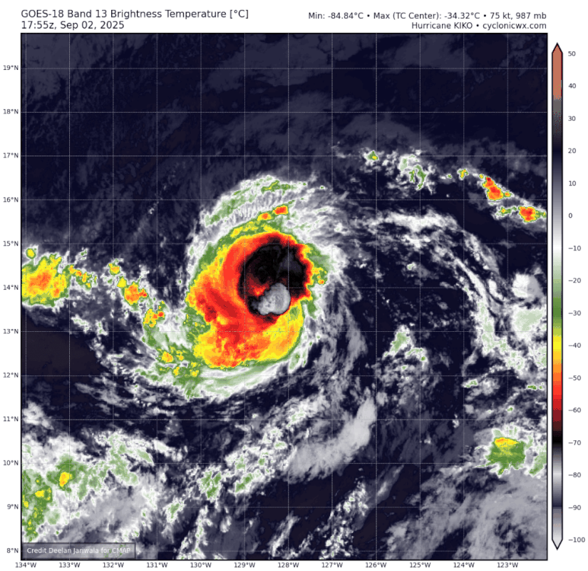
We have multiple subjective Dvorak fixes at T5.0 and objective numbers are only lower due to constraints - raw ADT #s are now over 5.5, in fact. The BT point (80 kts / 984 hPa) at 18z is a rather conservative call from the NHC, especially considering there's no recon for this storm & recent microwave imagery backs up the Dvorak estimates, but the 21z advisory may explain their reasoning. Not surprising considering that this is an EPac storm & not an immediate land threat - satellite estimates for Iona were treated with similar skepticism until the trend held for 12+ hours. In any case, the forecast peak of 100 kts seems all but certain to verify at this rate.
0 likes
-
cycloneye

- Admin

- Posts: 146439
- Age: 69
- Joined: Thu Oct 10, 2002 10:54 am
- Location: San Juan, Puerto Rico
Re: EPAC: KIKO - Hurricane - Discussion
Cat 2
BULLETIN
Hurricane Kiko Advisory Number 11
NWS National Hurricane Center Miami FL EP112025
1100 AM HST Tue Sep 02 2025
...HURRICANE KIKO CONTINUES TO STRENGTHEN...
SUMMARY OF 1100 AM HST...2100 UTC...INFORMATION
-----------------------------------------------
LOCATION...13.9N 128.9W
ABOUT 1775 MI...2855 KM E OF HILO HAWAII
MAXIMUM SUSTAINED WINDS...100 MPH...155 KM/H
PRESENT MOVEMENT...W OR 270 DEGREES AT 6 MPH...9 KM/H
MINIMUM CENTRAL PRESSURE...980 MB...28.94 INCHES
Hurricane Kiko Discussion Number 11
NWS National Hurricane Center Miami FL EP112025
1100 AM HST Tue Sep 02 2025
The eye of Kiko continues to gradually become better defined on
visible and infrared GOES-18 imagery. While the TAFB and SAB Dvorak
estimates of 4.5 (77 kt) and 5.0 (90 kt) are unchanged from 6 h ago,
the objective intensity estimates from UW-CIMSS have increased, and
now range from 70-85 kt. The latest SATCON and AiDT measurements
are both 83 kt, and the eye has continued to warm and become better
defined over the past couple of hours. The initial intensity is
increased to 85 kt for this advisory.
Kiko continues moving slowly westward, or 270 degrees at 5 kt. The
main steering feature continues to be the subtropical ridge located
to the north of Kiko. A slow westward motion should continue for
the next couple of days. A turn toward the west-northwest is
forecast by days 3 and 4 as an upper-level trough north of Hawaii
begins to erode the western portion of the subtropical ridge. There
remains above normal along-track spread in the model suite. The
latest NHC track forecast was sped up a bit from the previous
official forecast, and is relatively close to, but slightly slower
than, the latest TVCE consensus and GFEX.
Through the next 48 h, Kiko should remain over sea-surface
temperatures of 27-28C, with light to moderate easterly wind shear,
but the relatively dry and stable environment is making the
intensity forecast tricky. There is larger than normal spread among
the various intensity models. Between days 3 and 4, water
temperatures along Kiko's path will begin to decrease while it also
moves into a progressively drier air mass. The NHC intensity
forecast continues to lie at the high end of the guidance suite
through day 3, but is now close to the middle of guidance envelope
at days 4 and 5.
FORECAST POSITIONS AND MAX WINDS
INIT 02/2100Z 13.9N 128.9W 85 KT 100 MPH
12H 03/0600Z 13.8N 129.8W 95 KT 110 MPH
24H 03/1800Z 13.8N 131.0W 100 KT 115 MPH
36H 04/0600Z 13.9N 132.2W 100 KT 115 MPH
48H 04/1800Z 14.1N 133.6W 100 KT 115 MPH
60H 05/0600Z 14.2N 135.2W 90 KT 105 MPH
72H 05/1800Z 14.5N 136.5W 85 KT 100 MPH
96H 06/1800Z 15.5N 139.5W 80 KT 90 MPH
120H 07/1800Z 16.7N 142.8W 75 KT 85 MPH
$$
Forecaster Hagen
2 likes
Visit the Caribbean-Central America Weather Thread where you can find at first post web cams,radars
and observations from Caribbean basin members Click Here
and observations from Caribbean basin members Click Here


Re: EPAC: KIKO - Hurricane - Discussion
 |  |
Platform: SENTINEL-1A
Acquisition Date: 2025-09-02 14:31:09 UTC
Storm Name: EP112025 / KIKO
Storm ID: EP11
Storm Center Longitude: -128.150
Storm Center Latitude: 13.754
Incidence Angle (Degrees): 24.803
Quadrant 1 NE VMax (kts): 80.41
Quadrant 2 SE VMax (kts): 79.92
Quadrant 3 SW VMax (kts): 72.96
Quadrant 4 NW VMax (kts): 70.61
RMax (nmi): 8.00 - 12.00
SAR pass from today at 1430z had a vmax of 80kts. ADT was at 4.3 then and given how much ADT (especially Raw T) and IR appearance have improved since then I wouldn't be surprised if Kiko was a MH or close to it right now.
2 likes
-
Kingarabian
- S2K Supporter
- Posts: 16146
- Joined: Sat Aug 08, 2009 3:06 am
- Location: Honolulu, Hawaii
Re: EPAC: KIKO - Hurricane - Discussion
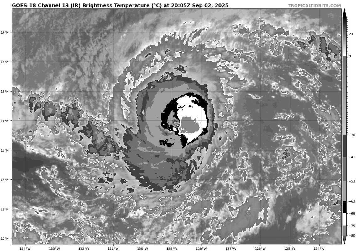
That eastern eyewall is firing off very cold cloud tops.
2 likes
RIP Kobe Bryant
Re: EPAC: KIKO - Hurricane - Discussion
If the western eyewall would improve just a bit its close to a complete W ring:

0 likes
-
Kingarabian
- S2K Supporter
- Posts: 16146
- Joined: Sat Aug 08, 2009 3:06 am
- Location: Honolulu, Hawaii
Re: EPAC: KIKO - Hurricane - Discussion
Travorum wrote:If the western eyewall would improve just a bit its close to a complete W ring:
https://i.imgur.com/VU0gAGu.png
Eastern eyewall going off like that means that it's still working out dry air. Looks like it's on its way in doing so.
0 likes
RIP Kobe Bryant
-
Hurricane2022

- Category 5
- Posts: 1654
- Joined: Tue Aug 23, 2022 11:38 pm
- Location: Araçatuba, Brazil
Re: EPAC: KIKO - Hurricane - Discussion
I'm getting some Gilma//Darby/Felicia/Fernanda '23 & '17/Douglas/Barbara/Kiko '19/Olivia (& etc) vibes with this hurricane now. It feels like I've already seen this show before. 
0 likes
Sorry for the bad English sometimes...!
For reliable and detailed information for any meteorological phenomenon, please consult the National Hurricane Center, Joint Typhoon Warning Center , or your local Meteo Center.
--------
Una cvm Christo, pro Christo, et in Christo. Sit nomen Domini benedictvm.
For reliable and detailed information for any meteorological phenomenon, please consult the National Hurricane Center, Joint Typhoon Warning Center , or your local Meteo Center.
--------
Una cvm Christo, pro Christo, et in Christo. Sit nomen Domini benedictvm.
-
Sciencerocks
- Category 5
- Posts: 9361
- Age: 39
- Joined: Thu Jul 06, 2017 1:51 am

-
Kingarabian
- S2K Supporter
- Posts: 16146
- Joined: Sat Aug 08, 2009 3:06 am
- Location: Honolulu, Hawaii
Re: EPAC: KIKO - Hurricane - Discussion
W now covers the entire CDO. If it manages to clear out its eye again, it'll be a top tier cat.4 or a cat.5.
0 likes
RIP Kobe Bryant
-
WaveBreaking

- Category 2

- Posts: 603
- Joined: Sun Jun 30, 2024 11:33 am
- Location: US
Re: EPAC: KIKO - Hurricane - Discussion

0 likes
I am NOT a professional meteorologist, so take all of my posts with a grain of salt. My opinions are mine and mine alone.
-
cycloneye
- Admin
- Posts: 146439
- Age: 69
- Joined: Thu Oct 10, 2002 10:54 am
- Location: San Juan, Puerto Rico
Re: EPAC: KIKO - Hurricane - Discussion
EP, 11, 2025090300, , BEST, 0, 138N, 1292W, 90, 970, HU
0 likes
Visit the Caribbean-Central America Weather Thread where you can find at first post web cams,radars
and observations from Caribbean basin members Click Here
and observations from Caribbean basin members Click Here
-
cycloneye
- Admin
- Posts: 146439
- Age: 69
- Joined: Thu Oct 10, 2002 10:54 am
- Location: San Juan, Puerto Rico
Re: EPAC: KIKO - Hurricane - Discussion
BULLETIN
Hurricane Kiko Advisory Number 12
NWS National Hurricane Center Miami FL EP112025
500 PM HST Tue Sep 02 2025
...KIKO INTENSIFIES TO CATEGORY 2 STRENGTH...
SUMMARY OF 500 PM HST...0300 UTC...INFORMATION
----------------------------------------------
LOCATION...13.8N 129.5W
ABOUT 1740 MI...2800 KM E OF HILO HAWAII
MAXIMUM SUSTAINED WINDS...105 MPH...165 KM/H
PRESENT MOVEMENT...W OR 270 DEGREES AT 7 MPH...11 KM/H
MINIMUM CENTRAL PRESSURE...970 MB...28.65 INCHES
Hurricane Kiko Discussion Number 12
NWS National Hurricane Center Miami FL EP112025
500 PM HST Tue Sep 02 2025
Recent satellite images show that the low-level center of Kiko is
now obscured by a large central dense overcast, possibly due to an
increase in northeasterly vertical wind shear, with the outflow now
somewhat restricted in the eastern semi-circle. A 02/2155Z AMRS2
microwave pass indicated that the cyclone continues to have a
well-defined inner-core, with a break in the eyewall evident in the
northwest quadrant at that time. The most recent subjective Dvorak
current intensity estimates from TAFB and SAB were both 5.0/90 kt,
while the objective estimates from UW-CIMSS have ranged between 72
and 92 kt during the past several hours. Taking a blend of these
data, the initial intensity for this advisory has been raised to 90
kt.
Kiko is moving due west, or 270 degrees, at 6 kt. This general
motion is expected to continue during the next 60 hours or so, as
the cyclone is steered by a building subtropical ridge to its north
and northwest. A turn toward the west-northwest is forecast by day
3 as an upper-level trough north of Hawaii begins to erode the
western portion of the subtropical ridge, with this general motion
then continuing through day 5. There remains considerable
along-track spread among the global models, with the GFS and ECMWF
still showing a 240 n mi difference in position on day 5. The
official track forecast remains in good agreement with a blend of
the latest multi-model consensus aids and is nearly on top of the
previous advisory, but with a slightly faster forward speed.
Kiko will remain over warm waters of 27–28C and influenced by most
light vertical wind shear through day 3. The surrounding
environmental mid-level moisture will remain drier than optimal,
hovering between 50 and 60 percent through day 3, then trending
below 50 percent by days 4 and 5. Despite the drier mid-level
airmass, the light vertical wind shear and warm sea surface
temperatures should maintain Kiko as a robust hurricane through day
3, with it likely being a major hurricane for much of that time. By
days 4 and 5, the cyclone will begin moving over cooler water with
gradually increasing westerly vertical wind shear. This should lead
to a steady weakening trend, but Kiko is still forecast to be a
hurricane at day 5. The official forecast is on the higher end of
the intensity guidance suite, and is most closely aligned with the
HCCA and regional hurricane model intensity aids.
FORECAST POSITIONS AND MAX WINDS
INIT 03/0300Z 13.8N 129.5W 90 KT 105 MPH
12H 03/1200Z 13.8N 130.5W 95 KT 110 MPH
24H 04/0000Z 13.8N 131.9W 100 KT 115 MPH
36H 04/1200Z 13.9N 133.4W 105 KT 120 MPH
48H 05/0000Z 14.1N 135.1W 105 KT 120 MPH
60H 05/1200Z 14.4N 136.9W 105 KT 120 MPH
72H 06/0000Z 14.8N 138.5W 95 KT 110 MPH
96H 07/0000Z 16.1N 141.4W 80 KT 90 MPH
120H 08/0000Z 17.3N 144.8W 70 KT 80 MPH
$$
Forecaster Jelsema (CPHC)
0 likes
Visit the Caribbean-Central America Weather Thread where you can find at first post web cams,radars
and observations from Caribbean basin members Click Here
and observations from Caribbean basin members Click Here
-
cycloneye
- Admin
- Posts: 146439
- Age: 69
- Joined: Thu Oct 10, 2002 10:54 am
- Location: San Juan, Puerto Rico
Re: EPAC: KIKO - Hurricane - Discussion
Hurricane Kiko Discussion Number 13
NWS National Hurricane Center Miami FL EP112025
1100 PM HST Tue Sep 02 2025
The low-level center of Kiko remained embedded in a large central
dense overcast through most of the past 12 hours, with only
the most recent satellite images now showing a more well-defined
eye developing surrounded by a ring of deep convection. The most
recent subjective Dvorak current intensity estimates from TAFB and
SAB were both 5.0/90 kt, while the objective estimates from UW-CIMSS
have ranged between 83 and 92 kt during the past several hours.
Based on these data and little overall change in the satellite
presentation since the previous advisory cycle, the initial
intensity has been held at 90 kt.
Kiko is moving due west, or 270 degrees, at 6 kt. This general
motion is expected to continue during the next couple of days, as
the cyclone is steered by a building subtropical ridge to its north
and northwest. A turn toward the west-northwest is forecast by day
3 as an upper-level trough north of Hawaii begins to erode the
western portion of the subtropical ridge, with this general motion
then continuing through day 5. There remains some along-track
spread among the global models, particularly beyond 24 hours, with
some cross track spread also noted toward the end of the forecast
resulting from differences in the handling of the upper-level trough
and subtropical ridge to the north of Kiko. The official track
forecast remains in good agreement with a blend of the latest
multi-model consensus aids and is nearly identical to the previous
advisory.
Kiko will remain over warm waters of 27–28C and influenced by most
light vertical wind shear through day 3. The surrounding
environmental mid-level moisture will remain drier than optimal,
hovering between 50 and 60 percent through 60 hours, then trending
below 50 percent by days 3 through 5. Despite the drier mid-level
airmass, the light vertical wind shear and warm sea surface
temperatures should maintain Kiko as a strong hurricane, with the
cyclone forecast to become a major hurricane on Wednesday and remain
at that status through day 3. By days 4 and 5, the cyclone will
begin moving over cooler water with gradually increasing westerly
vertical wind shear, and mid-level moisture plummeting below 40
percent. These factors should lead to a steady weakening, however,
Kiko is still forecast to be a hurricane on day 5. The official
forecast remains on the higher end of the intensity guidance suite,
and is most closely aligned with a blend of the FSSE/HCCA intensity
consensus aids.
FORECAST POSITIONS AND MAX WINDS
INIT 03/0900Z 13.8N 130.1W 90 KT 105 MPH
12H 03/1800Z 13.8N 131.2W 100 KT 115 MPH
24H 04/0600Z 13.9N 132.6W 105 KT 120 MPH
36H 04/1800Z 14.0N 134.2W 105 KT 120 MPH
48H 05/0600Z 14.2N 135.8W 105 KT 120 MPH
60H 05/1800Z 14.5N 137.4W 105 KT 120 MPH
72H 06/0600Z 15.0N 139.0W 100 KT 115 MPH
96H 07/0600Z 16.3N 142.2W 90 KT 105 MPH
120H 08/0600Z 17.5N 145.8W 75 KT 85 MPH
$$
Forecaster Jelsema (CPHC)
0 likes
Visit the Caribbean-Central America Weather Thread where you can find at first post web cams,radars
and observations from Caribbean basin members Click Here
and observations from Caribbean basin members Click Here
Return to “Active Storms/Invests - Atlantic/EastPAC/CentralPAC/MED”
Who is online
Users browsing this forum: No registered users and 44 guests