
EPAC: KIKO - Hurricane - Discussion
Moderators: hurricanetrack, S2k Moderators

The posts in this forum are NOT official forecasts and should not be used as such. They are just the opinion of the poster and may or may not be backed by sound meteorological data. They are NOT endorsed by any professional institution or STORM2K. For official information, please refer to products from the National Hurricane Center and National Weather Service.


Re: EPAC: KIKO - Hurricane - Discussion
Some awesome satellite views today I bet. Cat 4 no doubt on the verge if not already.
0 likes
The above post and any post by Ntxw is NOT an official forecast and should not be used as such. It is just the opinion of the poster and may or may not be backed by sound meteorological data. It is NOT endorsed by any professional institution including Storm2k. For official information, please refer to NWS products.
Help support Storm2K!
-
Kingarabian

- S2K Supporter

- Posts: 16154
- Joined: Sat Aug 08, 2009 3:06 am
- Location: Honolulu, Hawaii
-
cycloneye

- Admin

- Posts: 146460
- Age: 69
- Joined: Thu Oct 10, 2002 10:54 am
- Location: San Juan, Puerto Rico
Re: EPAC: KIKO - Hurricane - Discussion
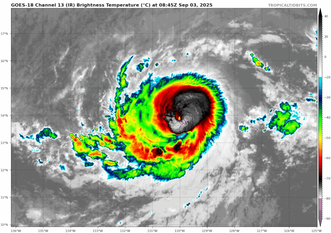
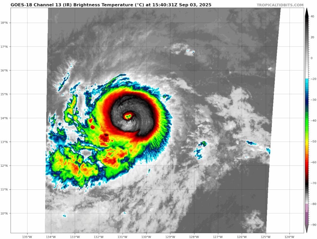
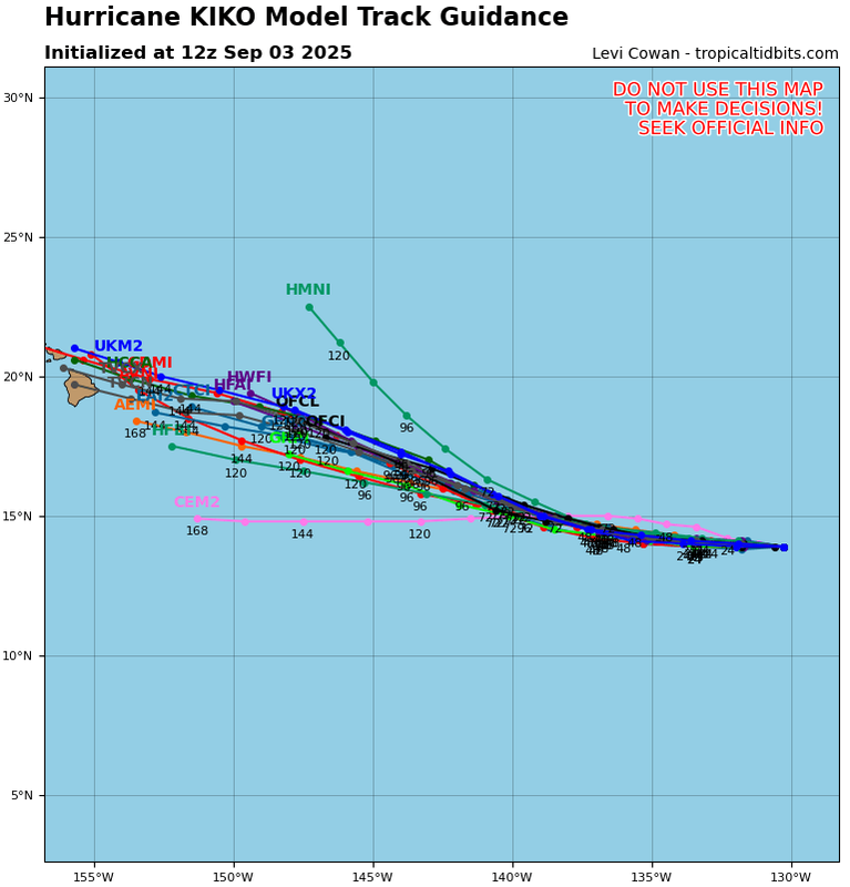
Hurricane Kiko Discussion Number 14
NWS National Hurricane Center Miami FL EP112025
Issued by the NWS Weather Prediction Center College Park MD
500 AM HST Wed Sep 03 2025
Kiko is getting better organized on satellite with an eye clearing
out over the past 6 to 12 hours with recent satellite images showing
the eye being surrounded by a ring of deep convection. The most
recent subjective Dvorak current intensity estimates from TAFB and
SAB were both 5.0/90 kt at 12Z but since that time the structure
has improved on satellite while the objective ADT estimate was 99
knots. The initial intensity has been set at 95 kt as a compromise
between these estimates.
Kiko is moving due west, or 270 degrees, at 7 kt. This general
motion is expected to continue during the next couple of days, as
the cyclone is steered by a building subtropical ridge to its north
and northwest. A turn toward the west-northwest is forecast by day
3 as an upper-level trough north of Hawaii erodes the western
portion of the subtropical ridge, with this general motion then
continuing through day 5. The track guidance this cycle was tightly
clustered through day 3. After that time, the European ensemble
shows a significant increase in spread in both the along- and
cross-track directions. The official track forecast remains close
to the HCCA and GDMI model solutions and is on the southern side
of the overall model envelope of solutions.
Kiko will remain over warm water and light vertical wind shear for
at least the next 3 days. Kiko's intensity will therefore likely
be governed by inner-core structural changes. Given its current
single eye-wall structure seen on earlier AMSR-2 microwave imagery,
Kiko appears poised to intensify more in the short term and the
latest intensity forecast shows more intensification than the
previous advisory. This intensity forecast is on the higher end of
the guidance suite closest to the HAFS-A and HAFS-B forecast over
the next 2 to 3 days. After that time, cooler SSTs and an increase
in southwesterly vertical wind shear should lead to gradual
weakening.
FORECAST POSITIONS AND MAX WINDS
INIT 03/1500Z 13.9N 130.6W 95 KT 110 MPH
12H 04/0000Z 13.9N 131.8W 110 KT 125 MPH
24H 04/1200Z 14.0N 133.4W 115 KT 130 MPH
36H 05/0000Z 14.2N 135.0W 115 KT 130 MPH
48H 05/1200Z 14.6N 136.9W 110 KT 125 MPH
60H 06/0000Z 14.8N 138.8W 105 KT 120 MPH
72H 06/1200Z 15.2N 140.6W 100 KT 115 MPH
96H 07/1200Z 16.8N 143.9W 90 KT 105 MPH
120H 08/1200Z 18.5N 147.7W 75 KT 85 MPH
$$
Forecaster Bann
0 likes
Visit the Caribbean-Central America Weather Thread where you can find at first post web cams,radars
and observations from Caribbean basin members Click Here
and observations from Caribbean basin members Click Here
-
Hurricane2022

- Category 5

- Posts: 1656
- Joined: Tue Aug 23, 2022 11:38 pm
- Location: Araçatuba, Brazil
Re: EPAC: KIKO - Hurricane - Discussion
The NHC should issue a update statement in the next few hours.


5 likes
Sorry for the bad English sometimes...!
For reliable and detailed information for any meteorological phenomenon, please consult the National Hurricane Center, Joint Typhoon Warning Center , or your local Meteo Center.
--------
Una cvm Christo, pro Christo, et in Christo. Sit nomen Domini benedictvm.
For reliable and detailed information for any meteorological phenomenon, please consult the National Hurricane Center, Joint Typhoon Warning Center , or your local Meteo Center.
--------
Una cvm Christo, pro Christo, et in Christo. Sit nomen Domini benedictvm.
-
StormWeather

- Category 1

- Posts: 332
- Joined: Wed Jun 05, 2024 2:34 pm
Re: EPAC: KIKO - Hurricane - Discussion
Hurricane2022 wrote:The NHC should issue a update statement in the next few hours.
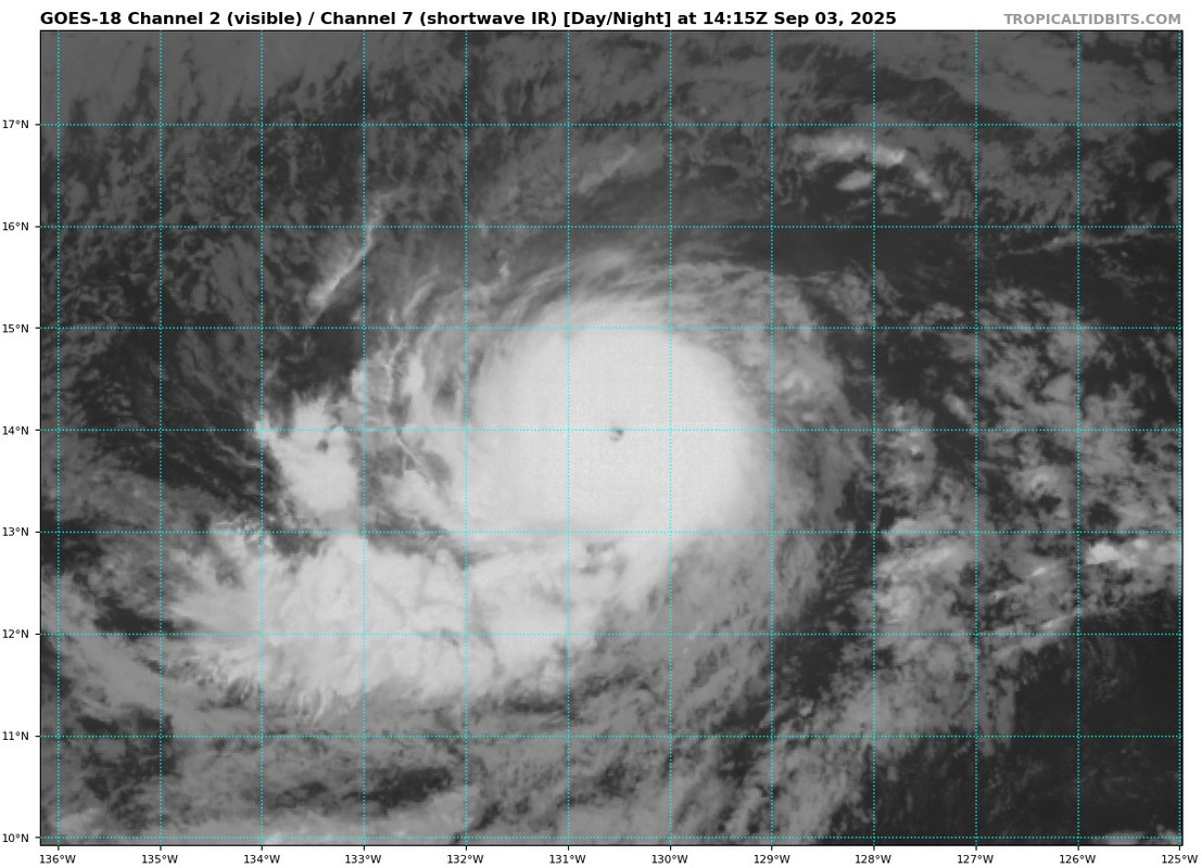
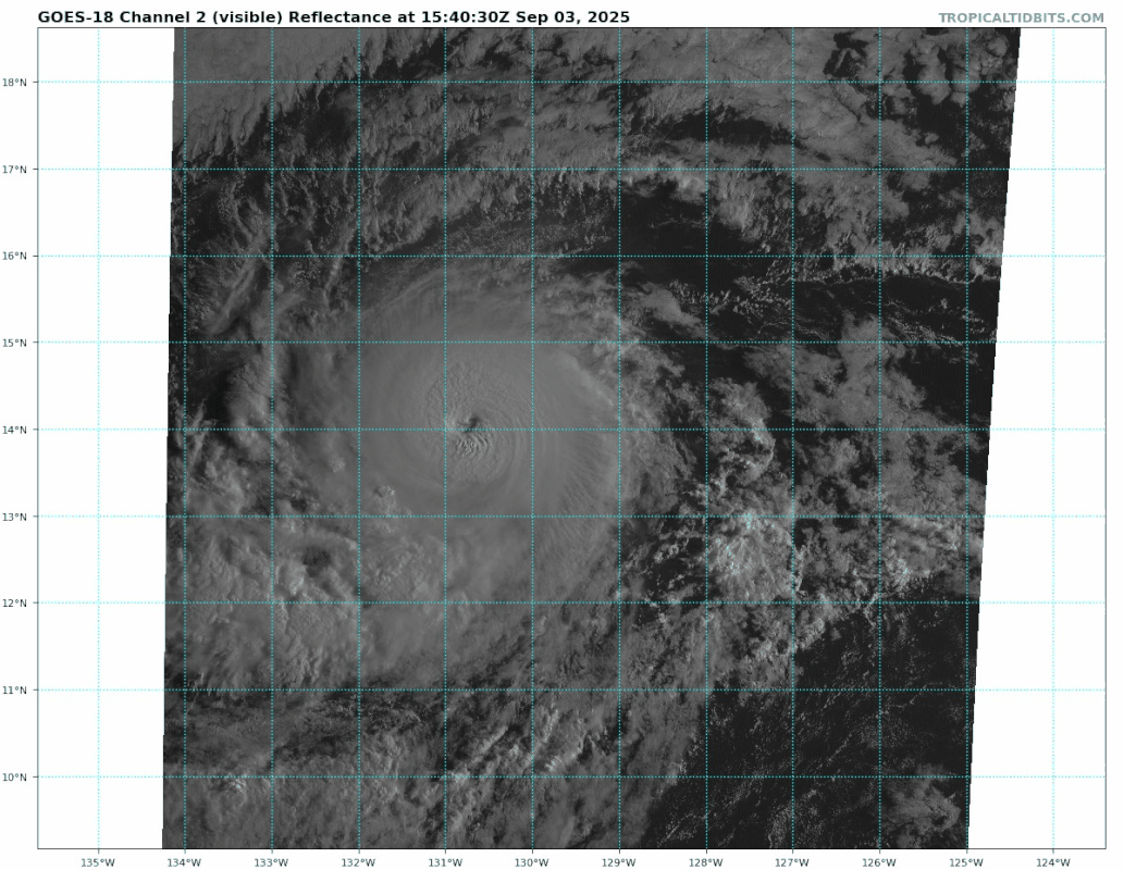
https://i.imgur.com/JsgSWwt.png https://i.imgur.com/8YarAMV.png
This thing looks like it’s knocking on the doorstep of Cat 4 already, if it isn’t a Cat 4 now.
2 likes
Just an average cyclone tracker
The posts in this forum are NOT official forecasts and should not be used as such. They are just the opinion of the poster and may or may not be backed by sound meteorological data. They are NOT endorsed by any professional institution or storm2k.org. For official information, please refer to the NHC and NWS products
The posts in this forum are NOT official forecasts and should not be used as such. They are just the opinion of the poster and may or may not be backed by sound meteorological data. They are NOT endorsed by any professional institution or storm2k.org. For official information, please refer to the NHC and NWS products
Re: EPAC: KIKO - Hurricane - Discussion

2 likes
The above post and any post by Ntxw is NOT an official forecast and should not be used as such. It is just the opinion of the poster and may or may not be backed by sound meteorological data. It is NOT endorsed by any professional institution including Storm2k. For official information, please refer to NWS products.
Help support Storm2K!
Help support Storm2K!

Re: EPAC: KIKO - Hurricane - Discussion
Never change, ADT:

Final T# Adj T# Raw T#
5.5 4.9 4.8
Center Temp : -63.0C Cloud Region Temp : -68.4C
Scene Type : UNIFORM CDO CLOUD REGION
5.5 4.9 4.8
Center Temp : -63.0C Cloud Region Temp : -68.4C
Scene Type : UNIFORM CDO CLOUD REGION
5 likes
-
Kingarabian
- S2K Supporter
- Posts: 16154
- Joined: Sat Aug 08, 2009 3:06 am
- Location: Honolulu, Hawaii
Re: EPAC: KIKO - Hurricane - Discussion
Travorum wrote:Never change, ADT:
https://i.imgur.com/8vTomiy.pngFinal T# Adj T# Raw T#
5.5 4.9 4.8
Center Temp : -63.0C Cloud Region Temp : -68.4C
Scene Type : UNIFORM CDO CLOUD REGION
Was just about to post this. Hot trash. Needs a manual adjustment.
2 likes
RIP Kobe Bryant
-
Yellow Evan

- Professional-Met

- Posts: 16178
- Age: 27
- Joined: Fri Jul 15, 2011 12:48 pm
- Location: Henderson, Nevada/Honolulu, HI
- Contact:
Re: EPAC: KIKO - Hurricane - Discussion
SAB and TAFB fixing 5.0 at 12z was odd given embedded B on IR at the time.
We probably are around 110 knots right now in reality.
We probably are around 110 knots right now in reality.
1 likes
-
Yellow Evan
- Professional-Met
- Posts: 16178
- Age: 27
- Joined: Fri Jul 15, 2011 12:48 pm
- Location: Henderson, Nevada/Honolulu, HI
- Contact:
Re: EPAC: KIKO - Hurricane - Discussion

Great CDO and rapidly warming eye. 115-125 knots inbound.
1 likes

-
StormWeather
- Category 1
- Posts: 332
- Joined: Wed Jun 05, 2024 2:34 pm
Re: EPAC: KIKO - Hurricane - Discussion
Teban54 wrote::double:
[url]https://i.postimg.cc/brN2QCBy/goes18-ir-meso1-1.gif [/url]
[url]https://i.postimg.cc/QC4KSQ2p/goes18-vis-meso1-1.gif [/url]
Best looking storm there all year since Iona and Erick.
1 likes
Just an average cyclone tracker
The posts in this forum are NOT official forecasts and should not be used as such. They are just the opinion of the poster and may or may not be backed by sound meteorological data. They are NOT endorsed by any professional institution or storm2k.org. For official information, please refer to the NHC and NWS products
The posts in this forum are NOT official forecasts and should not be used as such. They are just the opinion of the poster and may or may not be backed by sound meteorological data. They are NOT endorsed by any professional institution or storm2k.org. For official information, please refer to the NHC and NWS products
-
Kingarabian
- S2K Supporter
- Posts: 16154
- Joined: Sat Aug 08, 2009 3:06 am
- Location: Honolulu, Hawaii
Re: EPAC: KIKO - Hurricane - Discussion
Probably a special advisory at 2pm if it continues.
1 likes
RIP Kobe Bryant
-
Hurricane2022
- Category 5
- Posts: 1656
- Joined: Tue Aug 23, 2022 11:38 pm
- Location: Araçatuba, Brazil
Re: EPAC: KIKO - Hurricane - Discussion

Strong mesovortex activity in the eye.
2 likes
Sorry for the bad English sometimes...!
For reliable and detailed information for any meteorological phenomenon, please consult the National Hurricane Center, Joint Typhoon Warning Center , or your local Meteo Center.
--------
Una cvm Christo, pro Christo, et in Christo. Sit nomen Domini benedictvm.
For reliable and detailed information for any meteorological phenomenon, please consult the National Hurricane Center, Joint Typhoon Warning Center , or your local Meteo Center.
--------
Una cvm Christo, pro Christo, et in Christo. Sit nomen Domini benedictvm.
-
Kingarabian
- S2K Supporter
- Posts: 16154
- Joined: Sat Aug 08, 2009 3:06 am
- Location: Honolulu, Hawaii
-
Yellow Evan
- Professional-Met
- Posts: 16178
- Age: 27
- Joined: Fri Jul 15, 2011 12:48 pm
- Location: Henderson, Nevada/Honolulu, HI
- Contact:
Re: EPAC: KIKO - Hurricane - Discussion

Eye now positives. Most recent Dvorak frames have been DT=T6.0.
1 likes
-
Kingarabian
- S2K Supporter
- Posts: 16154
- Joined: Sat Aug 08, 2009 3:06 am
- Location: Honolulu, Hawaii
Re: EPAC: KIKO - Hurricane - Discussion
Looks like its also picking up speed.
0 likes
RIP Kobe Bryant
Return to “Active Storms/Invests - Atlantic/EastPAC/CentralPAC/MED”
Who is online
Users browsing this forum: Google [Bot], Majestic-12 [Bot] and 44 guests