
ATL: ERIN - Hurricane - Discussion
Moderators: hurricanetrack, S2k Moderators

The posts in this forum are NOT official forecasts and should not be used as such. They are just the opinion of the poster and may or may not be backed by sound meteorological data. They are NOT endorsed by any professional institution or STORM2K. For official information, please refer to products from the National Hurricane Center and National Weather Service.

-
tolakram
- Admin

- Posts: 20036
- Age: 62
- Joined: Sun Aug 27, 2006 8:23 pm
- Location: Florence, KY (name is Mark)
Re: ATL: ERIN - Hurricane - Discussion
Looks to be gaining convection again.
4 likes
M a r k
- - - - -
Join us in chat: Storm2K Chatroom Invite. Android and IOS apps also available.
The posts in this forum are NOT official forecasts and should not be used as such. Posts are NOT endorsed by any professional institution or STORM2K.org. For official information and forecasts, please refer to NHC and NWS products.
-
OuterBanker
- S2K Supporter

- Posts: 1750
- Joined: Wed Feb 26, 2003 10:53 am
- Location: Nags Head, NC
- Contact:
Re: ATL: ERIN - Hurricane - Discussion
Just hope this doesn't become another Isabel. Hurricane winds extended 185 miles from the center, tropical storm winds 555 from center.
4 likes

Re: ATL: ERIN - Hurricane - Discussion
mitchell wrote:Jr0d wrote:Here is the current GFS wave height predict. Keep in mind both the EURO and ICON are forecasting an even stronger storm as it approaches.
https://i.ibb.co/YHS3hY5/Screenshot-20250818-182607-Chrome.jpg
I won't be surprised if we get a few new inlets in the Outer Banks.
I would be very surprised if Erin creates the amount of storm surge into the sounds, and the rapid drainage that creates new inlets. To be sure there will be lots of wave runup, overwash, and sand deposition onto lots and roads and a real pounding. But unless the eye actually passes so close that hurricane force onshore winds are followed by a relatively rapid switch offshore with high enough surge level in the sounds to drain back across the barrier island and cut inlet channels on the ebb tide, I doubt inlet formation will happen. It takes a pretty specific set of conditions for real inlet formation.
Inlet may not be the right word, a cut through the barrier island to the sound is what I meant. It happens up there from time to time and they get filled in. Isabel in '03 did carve some inlets however that were filled.
I am basing this on the ICON model. If Erin goes further east and weaker then yes no inlets or passes will be carved out.
We shall see. Where the storm is already has winds and swell pointed towards the south OBX. As the storm moves north it will create a pseudo fetch that may add to the wave height potential which will cause more erosion.
I love the OBX and hope I am wrong. Much rather doomcast and be wrong than see another severe erosion and surge event up there. Sometimes I feel like when I post about bad scenarios they are less likely to happen...
Regardless the OBX have a dangerous, life and property weather event that is likely to unfold in this week.
1 likes

-
HurricaneRyan
- Category 3

- Posts: 819
- Age: 31
- Joined: Sun Dec 05, 2010 3:05 pm
Re: ATL: ERIN - Hurricane - Discussion
Erin is basically middle fingering all the models
0 likes
Kay '22 Hilary '23
-
NC George

- Category 2

- Posts: 635
- Age: 55
- Joined: Sun Sep 14, 2003 11:44 am
- Location: Washington, NC, USA
Re: ATL: ERIN - Hurricane - Discussion
72Packer wrote:
There are no homes on the North end of Ocracoke Island, facing south. Much of the island has eroded away. If this photo represents traffic leaving Ocracoke (or already crossed) to cross Hatteras Inlet, the line is about ten miles long on Ocracoke. This could be traffic being lined up on Hatteras Island to meter traffic through 50 miles of two lane road.
It's from the ferry dock on the N end of Ocracoke Island. You can go to Google Maps and see the exactly the same picture (just from the lower vantage point of a car,) but you can clearly see the flagpole and the red and green signs behind it farther down the road. The 'houses' you think you are seeing are just clumps of vegetation on the dunes.
1 likes
Bertha '96, Fran '96, Bonnie '98, Dennis '99, Floyd '99  , Isabel '03, Irene '11, Matthew '16, Isaias '20, PTC16????
Avatar is heading into Florence 2018, moving friend's boat, only land between us and Hurricane Florence is Ocracoke Island!
Avatar is heading into Florence 2018, moving friend's boat, only land between us and Hurricane Florence is Ocracoke Island!

Re: ATL: ERIN - Hurricane - Discussion
Just as a point of history: the highest tide in Buxton (Cape Hatteras) NC, history (at least until that pt. in time) 10.3 ft, came from the NW out of Pamlico Sound as Hurricane Emily, 1993, passed just offshore.
https://www.youtube.com/watch?v=rkrTHo8PcEk&t=6s
https://www.youtube.com/watch?v=rkrTHo8PcEk&t=6s
Last edited by canebeard on Tue Aug 19, 2025 3:56 am, edited 8 times in total.
0 likes
List of 79 tropical cyclones intercepted by Richard Horodner:
http://www.canebeard.com/page/page/572246.htm
former storm2k screenname Beoumont 2009+
http://www.canebeard.com/page/page/572246.htm
former storm2k screenname Beoumont 2009+
Re: ATL: ERIN - Hurricane - Discussion
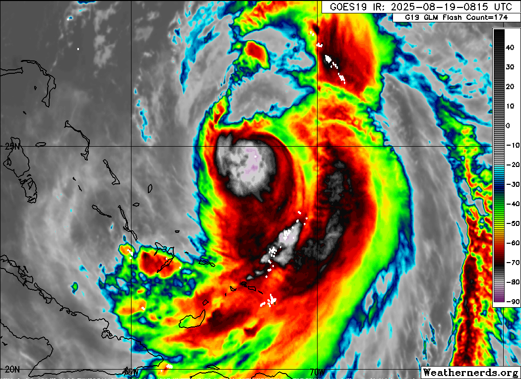
6Z Best Track:
Barely a Cat3. Will likely be down to a Cat2 in the next advisory, due shortly.
AL, 05, 2025081906, , BEST, 0, 245N, 718W, 100, 955, HU...
Barely a Cat3. Will likely be down to a Cat2 in the next advisory, due shortly.
1 likes


Re: ATL: ERIN - Hurricane - Discussion
Pressures way up in the 950's dry shear from the north must be undercutting the circulation.
How weak can she get before getting pulled back more WNW, she looks like she is going stationary?
How weak can she get before getting pulled back more WNW, she looks like she is going stationary?
1 likes

Re: ATL: ERIN - Hurricane - Discussion
Anti-cyclone south of Cuba is the main culprit for the shear Erin is feeling.
1 likes
Re: ATL: ERIN - Hurricane - Discussion
GCANE wrote:Anti-cyclone south of Cuba is the main culprit for the shear Erin is feeling.
Also, anti-cyclone is strengthening.
Erin is moving towards a large 355K PV streamer.
Not looking good for the future of Erin.
Great news for the east coast and Bermuda.
3 likes
Re: ATL: ERIN - Hurricane - Discussion
Rough looking on satellite this morning, especially on the north and west sides. Shear and upwelling are having an impact, it probably won't be tomorrow afternoon/evening until it has a shot at strengthening again. It it were moving faster you'd probably be seeing the naked swirl effect today.
0 likes

Re: ATL: ERIN - Hurricane - Discussion
Glad to see that shear really clobbered it overnight. She's moving just a hair west of due north according to the 5AM advisory (325 deg) pretty much as expected.
NHC has the closest west at 74deg W at this point, then hooking NE
NHC has the closest west at 74deg W at this point, then hooking NE
0 likes
I'm not a meteorologist, I'm an electronics engineer. While I can probably fix your toaster oven, you're not going to learn about storms from me!
New Mexico had no hurricanes. Then I moved to NC right before Fran.....
New Mexico had no hurricanes. Then I moved to NC right before Fran.....
-
jconsor
- Professional-Met

- Posts: 557
- Joined: Mon Jun 30, 2008 9:31 pm
- Location: Jerusalem, Israel
- Contact:
Re: ATL: ERIN - Hurricane - Discussion
Hurricane Erin, despite weakening significantly in the past 24 hours, may have one more round of strengthening in its arsenal.
With a fetch of tropical storm force winds extending out hundreds of miles into the ocean piling up water over three days of high tide cycles, water levels from NC to SE Virginia could rival levels during Dorian and Irene. The Delmarva Peninsula to southern NJ could see a top 5 water level on record as well!
https://hurricanehacker.substack.com/p/ ... or-comfort
4 likes
-
wxman57

- Moderator-Pro Met

- Posts: 23016
- Age: 67
- Joined: Sat Jun 21, 2003 8:06 pm
- Location: Houston, TX (southwest)
Re: ATL: ERIN - Hurricane - Discussion
It appears that the plane did not find any hurricane force wind in the southwest quadrant. Erin may be borderline Cat 1-2 now. It's wind field will be expanding significantly over the coming days. Windy along the East U.S. coast but heavy squalls should pass offshore. Not much rain along the coast.
2 likes
Re: ATL: ERIN - Hurricane - Discussion
wxman57 wrote:It appears that the plane did not find any hurricane force wind in the southwest quadrant. Erin may be borderline Cat 1-2 now. It's wind field will be expanding significantly over the coming days. Windy along the East U.S. coast but heavy squalls should pass offshore. Not much rain along the coast.
Do you think it will restrengthen as some models like the Euro show?
0 likes
Personal Forecast Disclaimer:
The posts in this forum are NOT official forecasts and should not be used as such. They are just the opinion of the poster and may or may not be backed by sound meteorological data. They are NOT endorsed by any professional institution or storm2k.org. For official information, please refer to the NHC and NWS products.
The posts in this forum are NOT official forecasts and should not be used as such. They are just the opinion of the poster and may or may not be backed by sound meteorological data. They are NOT endorsed by any professional institution or storm2k.org. For official information, please refer to the NHC and NWS products.
Re: ATL: ERIN - Hurricane - Discussion
The dry air seems to be doing the job as well. One thing, looking at the steering layers weaker is definitely more west
0 likes
-
invest man
- Tropical Storm

- Posts: 208
- Joined: Sun Aug 17, 2008 8:12 pm
Re: ATL: ERIN - Hurricane - Discussion
xironman wrote:The dry air seems to be doing the job as well. One thing, looking at the steering layers weaker is definitely more west
I was about to ask about that. So how much further west? West enough for a landfall in the TS watch area of ENC. I remember Irene “2011” deteriorating almost in this same area and causing chaos in ENC. Any ideas?
0 likes


Re: ATL: ERIN - Hurricane - Discussion
jconsor, thanks very much for the Substack article and the tidal flooding warning. We do NOT want another replay of Floyd or Isabel in the Hampton Roads area.
1 likes
Return to “Active Storms/Invests - Atlantic/EastPAC/CentralPAC/MED”
Who is online
Users browsing this forum: No registered users and 80 guests