
EPAC: LORENA - Tropical Storm - Discussion
Moderators: hurricanetrack, S2k Moderators

The posts in this forum are NOT official forecasts and should not be used as such. They are just the opinion of the poster and may or may not be backed by sound meteorological data. They are NOT endorsed by any professional institution or STORM2K. For official information, please refer to products from the National Hurricane Center and National Weather Service.

-
Sciencerocks
- Category 5

- Posts: 9361
- Age: 39
- Joined: Thu Jul 06, 2017 1:51 am
-
TomballEd
- Category 3

- Posts: 882
- Age: 61
- Joined: Wed Aug 16, 2023 4:52 pm
- Location: Spring/Klein area, not Tomball
Re: EPAC: LORENA - Tropical Storm - Discussion
Over a month early and likely not a strong Cat 2 like Hurricane Rosa, but the modeled path, a storm stripped of its LL circulation crossing the mountains but having an MLC with tropical moisture above the surface, rain threat for CONUS?
0 likes
-
vbhoutex

- Storm2k Executive

- Posts: 29117
- Age: 74
- Joined: Wed Oct 09, 2002 11:31 pm
- Location: Cypress, TX
- Contact:
Re: EPAC: LORENA - Tropical Storm - Discussion
TomballEd wrote:Over a month early and likely not a strong Cat 2 like Hurricane Rosa, but the modeled path, a storm stripped of its LL circulation crossing the mountains but having an MLC with tropical moisture above the surface, rain threat for CONUS?
I presume you've seen our local ocm and others in thee state are suggesting we will have a problem in Texas. I would expect it is a strong possibility.
1 likes
Skywarn, C.E.R.T.
Please click below to donate to STORM2K to help with the expenses of keeping the site going:

Please click below to donate to STORM2K to help with the expenses of keeping the site going:
-
cycloneye

- Admin
- Posts: 146429
- Age: 69
- Joined: Thu Oct 10, 2002 10:54 am
- Location: San Juan, Puerto Rico
Re: EPAC: LORENA - Tropical Storm - Discussion
EP, 12, 2025090218, , BEST, 0, 189N, 1083W, 45, 1002, TS
0 likes
Visit the Caribbean-Central America Weather Thread where you can find at first post web cams,radars
and observations from Caribbean basin members Click Here
and observations from Caribbean basin members Click Here
-
Kingarabian

- S2K Supporter

- Posts: 16146
- Joined: Sat Aug 08, 2009 3:06 am
- Location: Honolulu, Hawaii
Re: EPAC: LORENA - Tropical Storm - Discussion
vbhoutex wrote:TomballEd wrote:Over a month early and likely not a strong Cat 2 like Hurricane Rosa, but the modeled path, a storm stripped of its LL circulation crossing the mountains but having an MLC with tropical moisture above the surface, rain threat for CONUS?
I presume you've seen our local ocm and others in thee state are suggesting we will have a problem in Texas. I would expect it is a strong possibility.
This thing is massive. GFS has the remnants of Lorena moving slowly over Texas with an abundant amount of moisture.
0 likes
RIP Kobe Bryant
-
Kingarabian
- S2K Supporter
- Posts: 16146
- Joined: Sat Aug 08, 2009 3:06 am
- Location: Honolulu, Hawaii
-
cycloneye
- Admin
- Posts: 146429
- Age: 69
- Joined: Thu Oct 10, 2002 10:54 am
- Location: San Juan, Puerto Rico
Re: EPAC: LORENA - Tropical Storm - Discussion
BULLETIN
Tropical Storm Lorena Advisory Number 4
NWS National Hurricane Center Miami FL EP122025
Issued by the NWS Weather Prediction Center College Park MD
200 PM MST Tue Sep 02 2025
...TROPICAL STORM LORENA STRENGTHENING AND FORECAST TO BECOME A
HURRICANE TOMORROW...
...TROPICAL STORM WATCHES ISSUES FOR WESTERN PORTION OF BAJA
CALIFORNIA SUR...
SUMMARY OF 200 PM MST...2100 UTC...INFORMATION
----------------------------------------------
LOCATION...19.4N 109.0W
ABOUT 310 MI...495 KM W OF MANZANILLO MEXICO
ABOUT 250 MI...400 KM SSE OF CABO SAN LUCAS MEXICO
MAXIMUM SUSTAINED WINDS...50 MPH...85 KM/H
PRESENT MOVEMENT...NW OR 310 DEGREES AT 15 MPH...24 KM/H
MINIMUM CENTRAL PRESSURE...1002 MB...29.59 INCHES
Tropical Storm Lorena Discussion Number 4
NWS National Hurricane Center Miami FL EP122025
Issued by the NWS Weather Prediction Center College Park MD
200 PM MST Tue Sep 02 2025
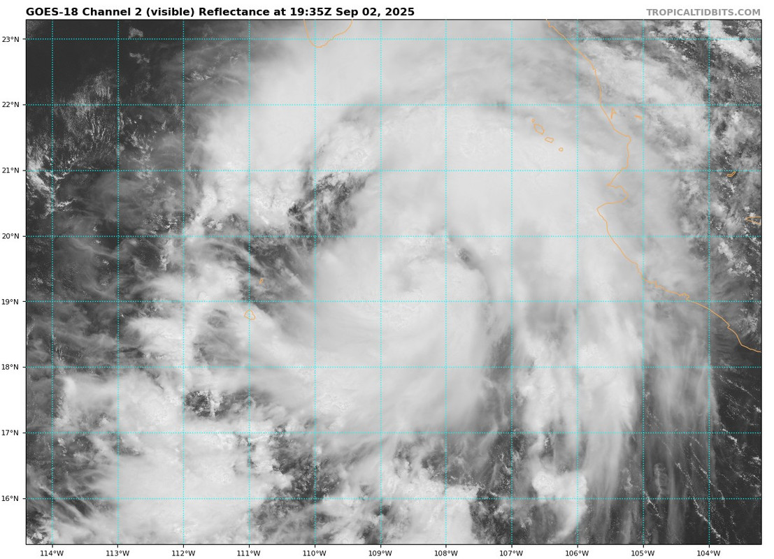
A 1548z METOP-B ASCAT pass provided solid coverage of Lorena's
overall wind field with also resulted in a northward adjustment to
the initial position. Since the ASCAT pass, GOES-East visible
imagery continues to show improving overall organization within an
ideal environment for further strengthening. Symmetric banding
features support Dvorak DT numbers of 3.0 and 3.5 from TAFB and SAB,
respectively. The recent inner core convection bursting with cloud
tops below -80C further suggest a strengthening trend, even without
recent microwave imagery to analyze its inner core structure. The
initial intensity is set at 45 kt, as a blend of the two operational
Dvorak estimates, along with other objective intensity estimates.
Since the prior advisory, Lorena is moving a bit faster at 13 kt to
the northwest as its being steered by the southwestern periphery of
the larger scale mid-level ridge. With the small northward
readjustment of position, the northwestward track will continue
through the next 48 hours, but this brings the center and wind field
closer to Baja California compared to the prior track forecast. As
such, the overall forecast track is a bit faster and shifted north
and east relative to prior forecast, following trends in the latest
track guidance. Due to the uncertainty that Tropical Storm force
winds may affect areas along the southwestern coasts of Baja
California Sur, the Government of Mexico has issued Tropical Storm
Watches from Cabo San Lucas northward to Cabo San Lazaro. Any
further deviations north and/or eastward may result in further
expansion of watches and/or warning conditions over the next 24 to
48 hours. Deep layer vertical shear and overall decaying
sea-surface environment will slow the forward speed, with slow
recurvature expected after 48 hours west of Baja California Sur.
The shear results in an expanding track forecast suite, though will
continue to prior trends and overall means recurving the cyclone
toward the central Baja California with initial landfall forecast
after 72 hours. What remains of the circulation will cross the
Peninsula tracking northeast with a second landfall along coastal
Sonora towards the end of the forecast period.
Lorena is expected to remain fairly small inner core, though with
ample moisture and warm sea-surface temperatures for the next 24 to
36 h, forecasts are for steady intensification toward hurricane
status by Wednesday. There is some potential that Lorena may rapidly
intensify in the short term given its structure and favorable
environment. As Lorena crosses the 26 C isotherm in 2-3 days,
vertical wind shear will also increase and the overall intensity
should start to weaken by late in the week. As the cyclone turns
northeastward, slow weakening is expected with eventual dissipation
over Sonora by Saturday. The intensity forecast is on the higher
end of the guidance envelope.
Key Messages:
1. Heavy rainfall associated with Tropical Storm Lorena will begin
to affect Baja California Sur on Wednesday, and southwestern Sonora
by Thursday. This will increase the risk of life-threatening flash
floods and mudslides, especially in areas of higher terrain.
2. Lorena is forecast to approach the Baja California peninsula
later this week. Due to the uncertainty that Tropical Storm force
winds may affect areas along the southwestern coasts of Baja
California Sur, the Government of Mexico has issued Tropical Storm
Watches from Cabo San Lucas northward to Cabo San Lazaro. Residents
should closely monitor the latest forecast updates and ensure that
they have their preparedness plan in place.
FORECAST POSITIONS AND MAX WINDS
INIT 02/2100Z 19.4N 109.0W 45 KT 50 MPH
12H 03/0600Z 20.6N 110.4W 55 KT 65 MPH
24H 03/1800Z 21.8N 112.0W 65 KT 75 MPH
36H 04/0600Z 22.9N 113.1W 75 KT 85 MPH
48H 04/1800Z 24.1N 113.8W 70 KT 80 MPH
60H 05/0600Z 25.1N 113.8W 55 KT 65 MPH
72H 05/1800Z 26.2N 113.3W 45 KT 50 MPH
96H 06/1800Z 28.4N 111.8W 35 KT 40 MPH
120H 07/1800Z 29.9N 110.3W 25 KT 30 MPH...POST-TROP/REMNT LOW
$$
Forecaster Gallina/Papin
Tropical Storm Lorena Advisory Number 4
NWS National Hurricane Center Miami FL EP122025
Issued by the NWS Weather Prediction Center College Park MD
200 PM MST Tue Sep 02 2025
...TROPICAL STORM LORENA STRENGTHENING AND FORECAST TO BECOME A
HURRICANE TOMORROW...
...TROPICAL STORM WATCHES ISSUES FOR WESTERN PORTION OF BAJA
CALIFORNIA SUR...
SUMMARY OF 200 PM MST...2100 UTC...INFORMATION
----------------------------------------------
LOCATION...19.4N 109.0W
ABOUT 310 MI...495 KM W OF MANZANILLO MEXICO
ABOUT 250 MI...400 KM SSE OF CABO SAN LUCAS MEXICO
MAXIMUM SUSTAINED WINDS...50 MPH...85 KM/H
PRESENT MOVEMENT...NW OR 310 DEGREES AT 15 MPH...24 KM/H
MINIMUM CENTRAL PRESSURE...1002 MB...29.59 INCHES
Tropical Storm Lorena Discussion Number 4
NWS National Hurricane Center Miami FL EP122025
Issued by the NWS Weather Prediction Center College Park MD
200 PM MST Tue Sep 02 2025
A 1548z METOP-B ASCAT pass provided solid coverage of Lorena's
overall wind field with also resulted in a northward adjustment to
the initial position. Since the ASCAT pass, GOES-East visible
imagery continues to show improving overall organization within an
ideal environment for further strengthening. Symmetric banding
features support Dvorak DT numbers of 3.0 and 3.5 from TAFB and SAB,
respectively. The recent inner core convection bursting with cloud
tops below -80C further suggest a strengthening trend, even without
recent microwave imagery to analyze its inner core structure. The
initial intensity is set at 45 kt, as a blend of the two operational
Dvorak estimates, along with other objective intensity estimates.
Since the prior advisory, Lorena is moving a bit faster at 13 kt to
the northwest as its being steered by the southwestern periphery of
the larger scale mid-level ridge. With the small northward
readjustment of position, the northwestward track will continue
through the next 48 hours, but this brings the center and wind field
closer to Baja California compared to the prior track forecast. As
such, the overall forecast track is a bit faster and shifted north
and east relative to prior forecast, following trends in the latest
track guidance. Due to the uncertainty that Tropical Storm force
winds may affect areas along the southwestern coasts of Baja
California Sur, the Government of Mexico has issued Tropical Storm
Watches from Cabo San Lucas northward to Cabo San Lazaro. Any
further deviations north and/or eastward may result in further
expansion of watches and/or warning conditions over the next 24 to
48 hours. Deep layer vertical shear and overall decaying
sea-surface environment will slow the forward speed, with slow
recurvature expected after 48 hours west of Baja California Sur.
The shear results in an expanding track forecast suite, though will
continue to prior trends and overall means recurving the cyclone
toward the central Baja California with initial landfall forecast
after 72 hours. What remains of the circulation will cross the
Peninsula tracking northeast with a second landfall along coastal
Sonora towards the end of the forecast period.
Lorena is expected to remain fairly small inner core, though with
ample moisture and warm sea-surface temperatures for the next 24 to
36 h, forecasts are for steady intensification toward hurricane
status by Wednesday. There is some potential that Lorena may rapidly
intensify in the short term given its structure and favorable
environment. As Lorena crosses the 26 C isotherm in 2-3 days,
vertical wind shear will also increase and the overall intensity
should start to weaken by late in the week. As the cyclone turns
northeastward, slow weakening is expected with eventual dissipation
over Sonora by Saturday. The intensity forecast is on the higher
end of the guidance envelope.
Key Messages:
1. Heavy rainfall associated with Tropical Storm Lorena will begin
to affect Baja California Sur on Wednesday, and southwestern Sonora
by Thursday. This will increase the risk of life-threatening flash
floods and mudslides, especially in areas of higher terrain.
2. Lorena is forecast to approach the Baja California peninsula
later this week. Due to the uncertainty that Tropical Storm force
winds may affect areas along the southwestern coasts of Baja
California Sur, the Government of Mexico has issued Tropical Storm
Watches from Cabo San Lucas northward to Cabo San Lazaro. Residents
should closely monitor the latest forecast updates and ensure that
they have their preparedness plan in place.
FORECAST POSITIONS AND MAX WINDS
INIT 02/2100Z 19.4N 109.0W 45 KT 50 MPH
12H 03/0600Z 20.6N 110.4W 55 KT 65 MPH
24H 03/1800Z 21.8N 112.0W 65 KT 75 MPH
36H 04/0600Z 22.9N 113.1W 75 KT 85 MPH
48H 04/1800Z 24.1N 113.8W 70 KT 80 MPH
60H 05/0600Z 25.1N 113.8W 55 KT 65 MPH
72H 05/1800Z 26.2N 113.3W 45 KT 50 MPH
96H 06/1800Z 28.4N 111.8W 35 KT 40 MPH
120H 07/1800Z 29.9N 110.3W 25 KT 30 MPH...POST-TROP/REMNT LOW
$$
Forecaster Gallina/Papin
0 likes
Visit the Caribbean-Central America Weather Thread where you can find at first post web cams,radars
and observations from Caribbean basin members Click Here
and observations from Caribbean basin members Click Here
-
Sciencerocks
- Category 5
- Posts: 9361
- Age: 39
- Joined: Thu Jul 06, 2017 1:51 am

Return to “Active Storms/Invests - Atlantic/EastPAC/CentralPAC/MED”
Who is online
Users browsing this forum: No registered users and 63 guests