NATL: MELISSA - Models
Moderators: hurricanetrack, S2k Moderators

The posts in this forum are NOT official forecasts and should not be used as such. They are just the opinion of the poster and may or may not be backed by sound meteorological data. They are NOT endorsed by any professional institution or STORM2K. For official information, please refer to products from the National Hurricane Center and National Weather Service.


Re: NATL: INVEST 98L - Models
Is it just me, or is it weird that the GFS looks like it’s developing a large eyed hurricane with Hispañola in the middle of it. The center is fully on land, but the pressure is going down.
0 likes


Re: NATL: INVEST 98L - Models
1 likes
-
SFLcane

- S2K Supporter

- Posts: 10275
- Age: 47
- Joined: Sat Jun 05, 2010 1:44 pm
- Location: Lake Worth Florida
Re: NATL: INVEST 98L - Models
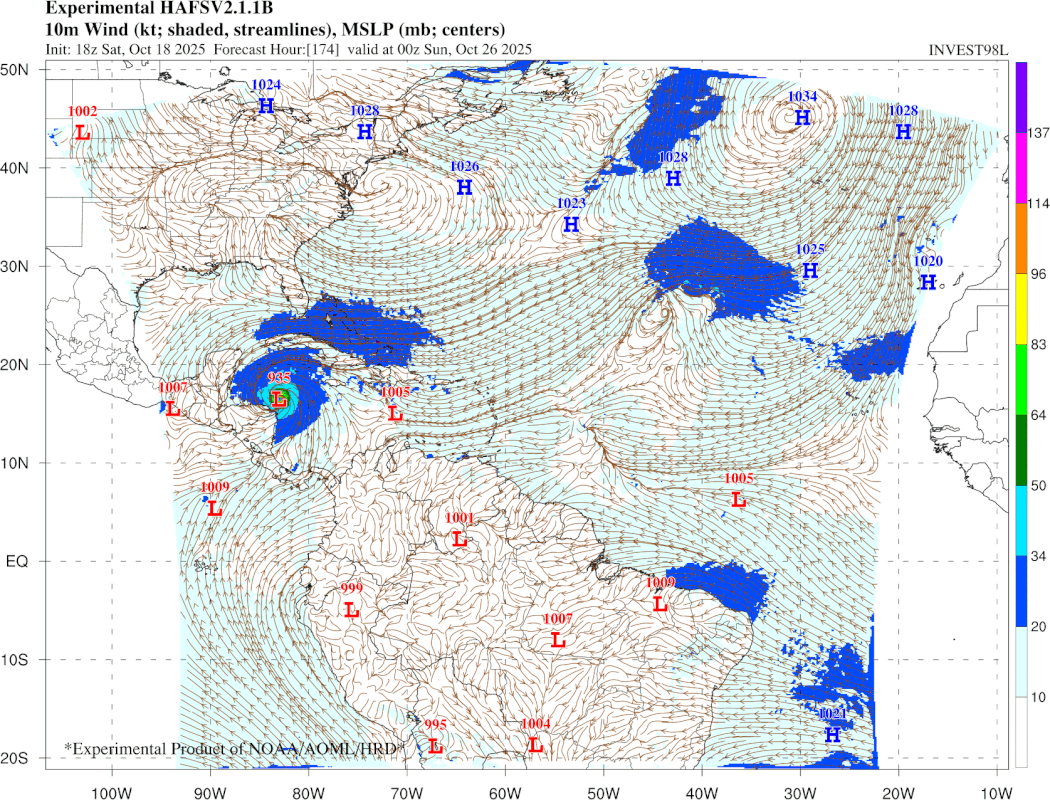
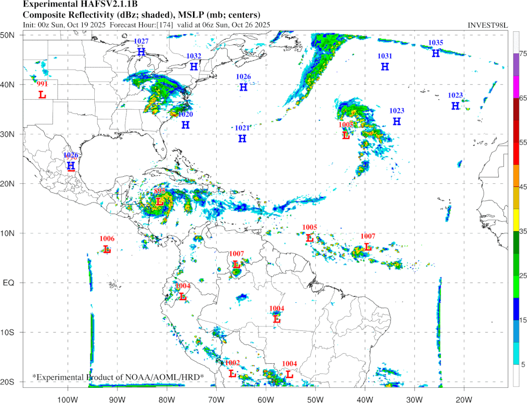
This is correct its ready to wilma there. Also posted Experimental HAFS-B likely a C5 there in the NW caribbean.
https://storm.aoml.noaa.gov/basin/anima ... casthr=000
2 likes
Re: NATL: INVEST 98L - Models
Midnight euro sends a strong cat 4 into Cuba and then what looks like a double whammy punch to the northeast.
Not to mention, looking at nearly 1-2 feet of rain for nearly the entirety of the northeast.
No thank you.
Not to mention, looking at nearly 1-2 feet of rain for nearly the entirety of the northeast.
No thank you.
1 likes
-
cycloneye

- Admin

- Posts: 147899
- Age: 69
- Joined: Thu Oct 10, 2002 10:54 am
- Location: San Juan, Puerto Rico
Re: NATL: INVEST 98L - Models
06z GFS with the same scenario crawling over Hispaniola.
The 00z Euro ensembles are in Western Caribbean with many members very strong.
Google Deep Mind at 00z had a west shift, but still are divided with many over Haiti, DR and the rest in Western Caribbean.

The 00z Euro ensembles are in Western Caribbean with many members very strong.
Google Deep Mind at 00z had a west shift, but still are divided with many over Haiti, DR and the rest in Western Caribbean.
1 likes
Visit the Caribbean-Central America Weather Thread where you can find at first post web cams,radars
and observations from Caribbean basin members Click Here
and observations from Caribbean basin members Click Here
Re: NATL: INVEST 98L - Models
cycloneye wrote:06z GFS with the same scenario crawling over Hispaniola.
The 00z Euro ensembles are in Western Caribbean with many members very strong.
Google Deep Mind at 00z had a west shift, but still are divided with many over Haiti, DR and the rest in Western Caribbean.
https://i.imgur.com/ucu3vhX.jpeg
It also seems like a good number of the euro ensembles tries to take a major into the northeast.
0 likes
-
SFLcane
- S2K Supporter
- Posts: 10275
- Age: 47
- Joined: Sat Jun 05, 2010 1:44 pm
- Location: Lake Worth Florida
Re: NATL: INVEST 98L - Models
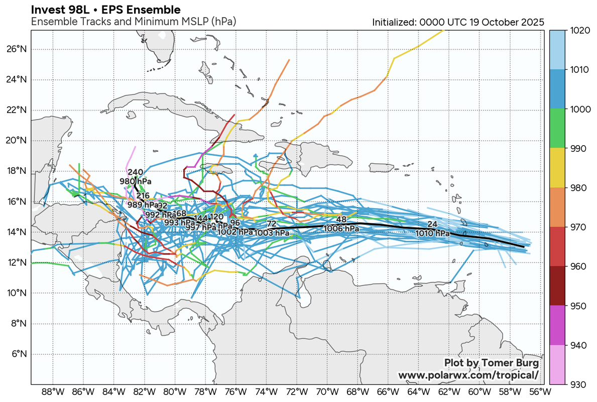
00z halfs still showing a monster cane in the NW carib sea heading NW at the end of its run.
3 likes
-
jlauderdal
- S2K Supporter
- Posts: 7229
- Joined: Wed May 19, 2004 5:46 am
- Location: NE Fort Lauderdale
- Contact:
Re: RE: Re: NATL: INVEST 98L - Models
Good old October delivering againSFLcane wrote:00z halfs still showing a monster cane in the NW carib sea heading NW at the end of its run.
1 likes
Re: NATL: INVEST 98L - Models
SFLcane wrote:00z halfs still showing a monster cane in the NW carib sea heading NW at the end of its run.
https://i.postimg.cc/5tC8TPx7/vvvv.gif
Yeah, that’s a monster cane all right. The sheer level of both potential and uncertainty with this storm is going to make the next week a massive headache.
1 likes
Re: NATL: INVEST 98L - Models
The 0Z UKMET once again has just a rather weak low (not even a TC on the textual output; it has yet to show TCG in the Caribbean on this output though it awhile back had several runs with TCG east of the Lesser Antilles) and again into Nicaragua. The last 5 runs have shown a weak low either hitting Nicaragua (0Z 10/19, 12Z 10/18), barely E of Nic. but heading into it (0Z 10/18, 12Z 10/17), or still 200 miles E of Nic. but likely headed into it (0Z 10/17).
Looking at the H5 vorticity, it appears that as the AOI on the TWO comes into the E Car that a portion of it turns sharply right like the GFS but unlike that model it never develops. Then what looks like a split from this, possibly incorporating additional vorticity coming off northern S America, causes the weak low to move into the SW Caribbean, and then into Nicaragua.
So, the UKMET remains a SW outlier. I should add that yesterday’s 12Z JMA is similar and it has been similar all of the way back to the 12Z 10/15 run. So, the JMA has had 4 12Z runs in a row with just a weak low into Nicaragua or just offshore headed there.
Thus the UKMET and JMA have a good chance to both either fail badly or end up doing the best of the major operationals with this.
Last edited by LarryWx on Sun Oct 19, 2025 8:02 am, edited 2 times in total.
0 likes
Personal Forecast Disclaimer:
The posts in this forum are NOT official forecasts and should not be used as such. They are just the opinion of the poster and may or may not be backed by sound meteorological data. They are NOT endorsed by any professional institution or storm2k.org. For official information, please refer to the NHC and NWS products.
The posts in this forum are NOT official forecasts and should not be used as such. They are just the opinion of the poster and may or may not be backed by sound meteorological data. They are NOT endorsed by any professional institution or storm2k.org. For official information, please refer to the NHC and NWS products.
-
jconsor
- Professional-Met

- Posts: 563
- Joined: Mon Jun 30, 2008 9:31 pm
- Location: Jerusalem, Israel
- Contact:
Re: NATL: INVEST 98L - Models
AIFS seems off showing too much of a hole in the W Atl ridging N/NW of 98L. The other ML models don't support its scenario of 98L curving sharply NE toward Hispaniola.
https://x.com/yconsor/status/1979887548240650357
https://x.com/yconsor/status/1979887548240650357
3 likes
-
jlauderdal
- S2K Supporter
- Posts: 7229
- Joined: Wed May 19, 2004 5:46 am
- Location: NE Fort Lauderdale
- Contact:
Re: NATL: INVEST 98L - Models
Fancy1002 wrote:It looks like the hurricane models aren’t going to be very helpful for the next couple days.
Global ensembles for now, this is far from settled and you can see the real danger for Cycloneyes area on the way in and the way out if it ejects their way.
0 likes
-
Blown Away

- S2K Supporter
- Posts: 10216
- Joined: Wed May 26, 2004 6:17 am
Re: NATL: INVEST 98L - Models
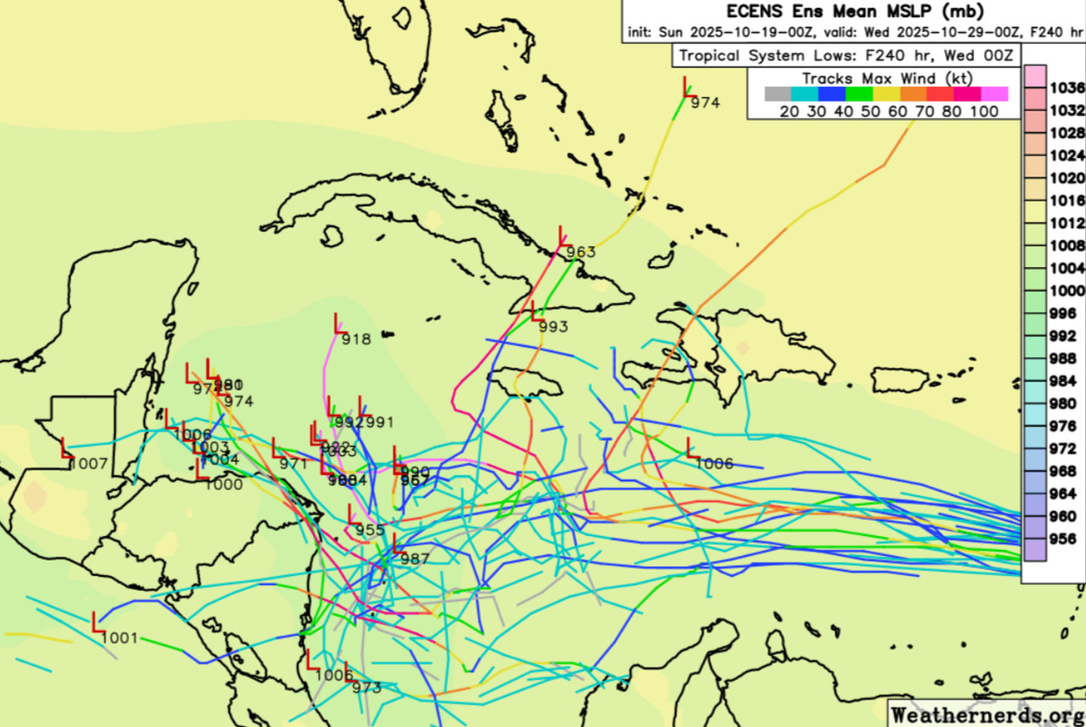
00z ECENS
1 likes
Hurricane Eye Experience: David 79, Irene 99, Frances 04, Jeanne 04, Wilma 05… Hurricane Brush Experience: Andrew 92, Erin 95, Floyd 99, Matthew 16, Irma 17, Ian 22, Nicole 22…
-
wzrgirl1

- S2K Supporter
- Posts: 1359
- Joined: Sat Sep 04, 2004 6:44 am
- Location: Pembroke Pines, Florida
Re: NATL: INVEST 98L - Models
Of course I’m concerned for everybody, but I live in South Florida. Are there any models showing a direct hit on us right now from what I can see there were one or two outliers but I just wanted to get some of your opinions.
0 likes


-
Hurricane2022

- Category 5

- Posts: 1760
- Joined: Tue Aug 23, 2022 11:38 pm
- Location: Araçatuba, Brazil
Re: NATL: INVEST 98L - Models


1 likes
Sorry for the bad English sometimes...!
For reliable and detailed information for any meteorological phenomenon, please consult the National Hurricane Center, Joint Typhoon Warning Center , or your local Meteo Center.
--------
Una cvm Christo, pro Christo, et in Christo. Sit nomen Domini benedictvm.
For reliable and detailed information for any meteorological phenomenon, please consult the National Hurricane Center, Joint Typhoon Warning Center , or your local Meteo Center.
--------
Una cvm Christo, pro Christo, et in Christo. Sit nomen Domini benedictvm.
Return to “Active Storms/Invests - Atlantic/EastPAC/CentralPAC/MED”
Who is online
Users browsing this forum: Category5Kaiju, Deshaunrob17, pepecool20 and 85 guests