ATL: ERIN - Tropical Storm - Discussion

Current storms and invests:

Moderators: hurricanetrack, S2k Moderators


The posts in this forum are NOT official forecasts and should not be used as such. They are just the opinion of the poster and may or may not be backed by sound meteorological data. They are NOT endorsed by any professional institution or STORM2K. For official information, please refer to products from the National Hurricane Center and National Weather Service.

Help Support Storm2K
Message
Author
MEANINGLESS_NUMBERS
Category 1
Category 1
Posts: 345
Joined: Mon Nov 02, 2020 1:43 pm

Re: ATL: ERIN - Tropical Storm - Discussion

#241 Postby MEANINGLESS_NUMBERS » Wed Aug 13, 2025 7:11 am

cycloneye wrote:11 PM advisorie has two M's at the end of forecast period at graphic. Still southern side of cone is over some of the northern leeward islands, BVI and U.SVI.

https://i.imgur.com/GUbaXkc.png


Although some of the islands are in the cone, the model consensus at that point is fairly tight and spares them. So perhaps lower risk than you might typically feel at the edge of the cone.
0 likes   
Emily '87, Felix '95, Gert '99, Fabian '03, Humberto '19, Paulette '20, Teddy '20, Fiona '22, Lee '23, Ernesto '24

User avatar
NDG
S2K Supporter
S2K Supporter
Posts: 15456
Joined: Sun Jul 09, 2006 10:14 pm
Location: Orlando, FL

Re: ATL: ERIN - Tropical Storm - Discussion

#242 Postby NDG » Wed Aug 13, 2025 7:24 am

The SE US is very lucky the -NAO is going negative just in time.

 https://x.com/NDGMETCHEF/status/1955605196937003487

0 likes   

User avatar
cycloneye
Admin
Admin
Posts: 145922
Age: 69
Joined: Thu Oct 10, 2002 10:54 am
Location: San Juan, Puerto Rico

Re: ATL: ERIN - Tropical Storm - Discussion

#243 Postby cycloneye » Wed Aug 13, 2025 7:54 am

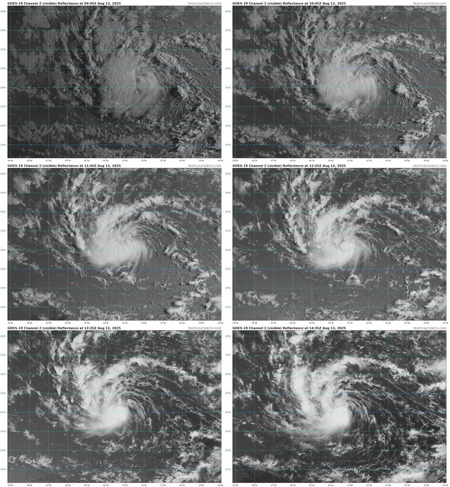
A new burst of deep convection over the circulation.

Image
0 likes   
Visit the Caribbean-Central America Weather Thread where you can find at first post web cams,radars
and observations from Caribbean basin members Click Here

jlauderdal
S2K Supporter
S2K Supporter
Posts: 7189
Joined: Wed May 19, 2004 5:46 am
Location: NE Fort Lauderdale
Contact:

Re: ATL: ERIN - Tropical Storm - Discussion

#244 Postby jlauderdal » Wed Aug 13, 2025 8:02 am

Nimbus wrote:Erin looks pretty weak this morning she is drying out between convective bursts but will be over warmer SST's as she crosses -45W and still has a closed circulation center. Weakness dropping down over Bermuda overnight still too far north for a weak system to feel. Small chance Erin ends up too far south and doesn't get picked up in time like Irma.

The post count on the globals thread might outpace this thread in the next few days. :D
0 likes   

MEANINGLESS_NUMBERS
Category 1
Category 1
Posts: 345
Joined: Mon Nov 02, 2020 1:43 pm

Re: ATL: ERIN - Tropical Storm - Discussion

#245 Postby MEANINGLESS_NUMBERS » Wed Aug 13, 2025 8:22 am

cycloneye wrote:A new burst of deep convection over the circulation.

https://i.imgur.com/4pl8RRK.png


She is started to get "that look"
0 likes   
Emily '87, Felix '95, Gert '99, Fabian '03, Humberto '19, Paulette '20, Teddy '20, Fiona '22, Lee '23, Ernesto '24

User avatar
wxman57
Moderator-Pro Met
Moderator-Pro Met
Posts: 22997
Age: 67
Joined: Sat Jun 21, 2003 8:06 pm
Location: Houston, TX (southwest)

Re: ATL: ERIN - Tropical Storm - Discussion

#246 Postby wxman57 » Wed Aug 13, 2025 8:30 am

MEANINGLESS_NUMBERS wrote:
cycloneye wrote:11 PM advisorie has two M's at the end of forecast period at graphic. Still southern side of cone is over some of the northern leeward islands, BVI and U.SVI.

https://i.imgur.com/GUbaXkc.png


Although some of the islands are in the cone, the model consensus at that point is fairly tight and spares them. So perhaps lower risk than you might typically feel at the edge of the cone.


As a reminder the cone is meaningless as far as potential impacts. It has nothing to do with forecast confidence for this storm, and it does not have anything to do with Erin's projected wind field or squalls. All the cone represents is a 5-year average track error. It says that 66.7% of the time over the past five seasons, the center of the storm tracked somewhere within that cone. Do NOT use the cone for planning purposes or to assess potential storm impacts.
6 likes   

User avatar
Bizzles
Category 1
Category 1
Posts: 473
Age: 39
Joined: Wed Oct 27, 2010 10:22 am
Location: Columbus, NJ

Re: ATL: ERIN - Tropical Storm - Discussion

#247 Postby Bizzles » Wed Aug 13, 2025 8:38 am

wxman57 wrote:
MEANINGLESS_NUMBERS wrote:
cycloneye wrote:11 PM advisorie has two M's at the end of forecast period at graphic. Still southern side of cone is over some of the northern leeward islands, BVI and U.SVI.

https://i.imgur.com/GUbaXkc.png


Although some of the islands are in the cone, the model consensus at that point is fairly tight and spares them. So perhaps lower risk than you might typically feel at the edge of the cone.


As a reminder the cone is meaningless as far as potential impacts. It has nothing to do with forecast confidence for this storm, and it does not have anything to do with Erin's projected wind field or squalls. All the cone represents is a 5-year average track error. It says that 66.7% of the time over the past five seasons, the center of the storm tracked somewhere within that cone. Do NOT use the cone for planning purposes or to assess potential storm impacts.

Great point Wxman57! Would you share what products you would keep an eye on as we get closer to better understand what potential impacts (surge, wind, etc) could be?
0 likes   
Andrew '92 Opal '95 Blizzard '96 Izzy '03 Irene '11 Sandy '12

The following post is NOT an official forecast and should not be used as such. It is just the opinion is not be backed by sound meteorological data. It is NOT endorsed by any professional institution including storm2k.org For Official Information please refer to the NHC and NWS products.

MEANINGLESS_NUMBERS
Category 1
Category 1
Posts: 345
Joined: Mon Nov 02, 2020 1:43 pm

Re: ATL: ERIN - Tropical Storm - Discussion

#248 Postby MEANINGLESS_NUMBERS » Wed Aug 13, 2025 9:00 am

wxman57 wrote:
MEANINGLESS_NUMBERS wrote:
cycloneye wrote:11 PM advisorie has two M's at the end of forecast period at graphic. Still southern side of cone is over some of the northern leeward islands, BVI and U.SVI.

https://i.imgur.com/GUbaXkc.png


Although some of the islands are in the cone, the model consensus at that point is fairly tight and spares them. So perhaps lower risk than you might typically feel at the edge of the cone.


As a reminder the cone is meaningless as far as potential impacts. It has nothing to do with forecast confidence for this storm, and it does not have anything to do with Erin's projected wind field or squalls. All the cone represents is a 5-year average track error. It says that 66.7% of the time over the past five seasons, the center of the storm tracked somewhere within that cone. Do NOT use the cone for planning purposes or to assess potential storm impacts.


That's my point - it is based on historical average error which may be more or less applicable to any given storm. This storm, there appears to be higher-than-average consensus through 5 days, so the center is more likely to stay within the cone. And as you say, wind field may extend well beyond the center, etc. The northern leeward islands will likely feel some impacts but hopefully will be spared the worst of it.
0 likes   
Emily '87, Felix '95, Gert '99, Fabian '03, Humberto '19, Paulette '20, Teddy '20, Fiona '22, Lee '23, Ernesto '24

User avatar
wxman57
Moderator-Pro Met
Moderator-Pro Met
Posts: 22997
Age: 67
Joined: Sat Jun 21, 2003 8:06 pm
Location: Houston, TX (southwest)

Re: ATL: ERIN - Tropical Storm - Discussion

#249 Postby wxman57 » Wed Aug 13, 2025 9:18 am

Bizzles wrote:
wxman57 wrote:
MEANINGLESS_NUMBERS wrote:
Although some of the islands are in the cone, the model consensus at that point is fairly tight and spares them. So perhaps lower risk than you might typically feel at the edge of the cone.


As a reminder the cone is meaningless as far as potential impacts. It has nothing to do with forecast confidence for this storm, and it does not have anything to do with Erin's projected wind field or squalls. All the cone represents is a 5-year average track error. It says that 66.7% of the time over the past five seasons, the center of the storm tracked somewhere within that cone. Do NOT use the cone for planning purposes or to assess potential storm impacts.

Great point Wxman57! Would you share what products you would keep an eye on as we get closer to better understand what potential impacts (surge, wind, etc) could be?


Unless you have access to your own meteorologist, then it's best to pay attention to the latest official information from the NHC and your local NWS office. I always read the forecast discussions to get an idea what the forecaster was thinking. For you in NJ, surf's up come next Thursday/Friday! Erin should be a very large and powerful hurricane next Wednesday as it passes by Bermuda. Lots of big waves into the coast as it passes.
4 likes   

Cachondo23
Tropical Depression
Tropical Depression
Posts: 88
Joined: Wed May 25, 2022 5:56 am

Re: ATL: ERIN - Tropical Storm - Discussion

#250 Postby Cachondo23 » Wed Aug 13, 2025 9:50 am

Currently at 16.4N, how low will it go?
0 likes   

User avatar
Teban54
Category 5
Category 5
Posts: 3210
Joined: Sat May 19, 2018 1:19 pm

Re: ATL: ERIN - Tropical Storm - Discussion

#251 Postby Teban54 » Wed Aug 13, 2025 9:50 am

Image
0 likes   


Return to “Active Storms/Invests - Atlantic/EastPAC/CentralPAC/MED”

Who is online

Users browsing this forum: No registered users and 70 guests