
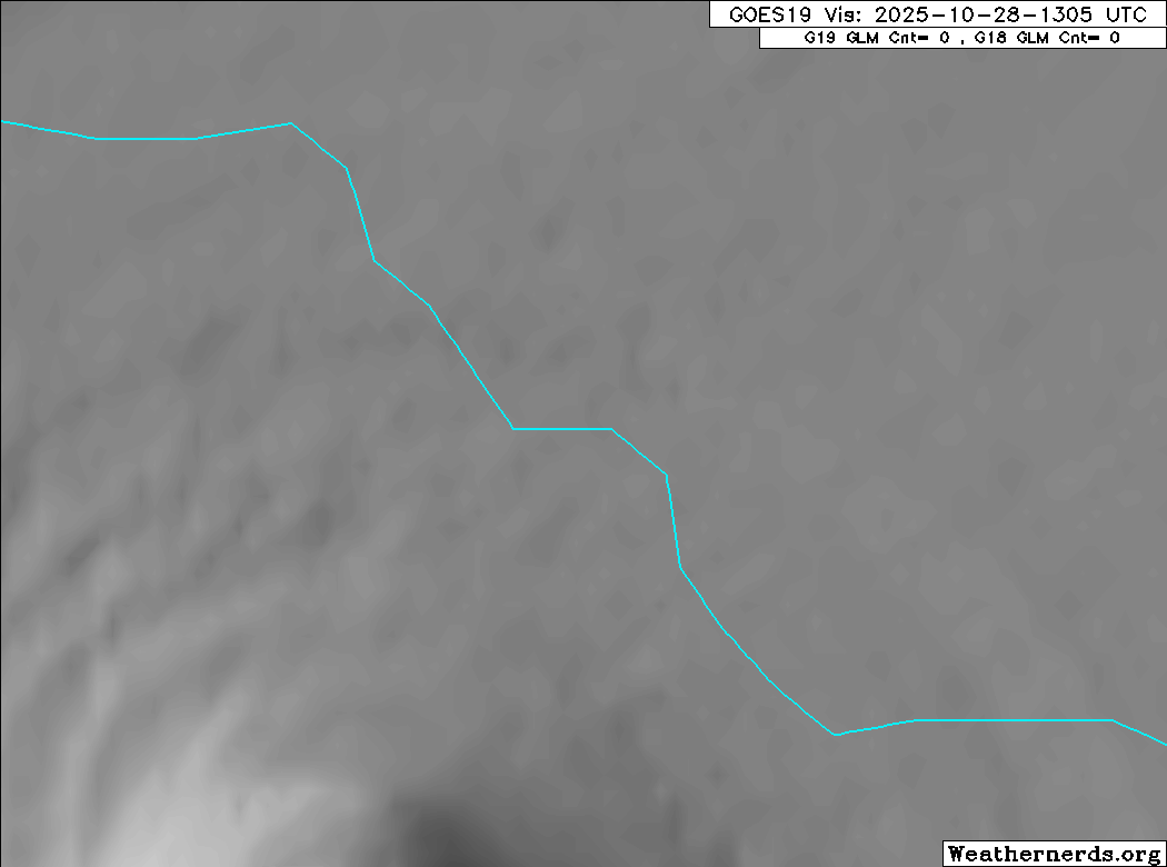
https://x.com/Jeff_Piotrowski/status/1983210346249699346
NATL: MELISSA - Hurricane - Discussion
Moderators: hurricanetrack, S2k Moderators

The posts in this forum are NOT official forecasts and should not be used as such. They are just the opinion of the poster and may or may not be backed by sound meteorological data. They are NOT endorsed by any professional institution or STORM2K. For official information, please refer to products from the National Hurricane Center and National Weather Service.

-
Blown Away

- S2K Supporter

- Posts: 10252
- Joined: Wed May 26, 2004 6:17 am
Re: NATL: MELISSA - Hurricane - Discussion: Update= 185mph/892mb at 12 PM
Getting close!
5 likes
Hurricane Eye Experience: David 79, Irene 99, Frances 04, Jeanne 04, Wilma 05… Hurricane Brush Experience: Andrew 92, Erin 95, Floyd 99, Matthew 16, Irma 17, Ian 22, Nicole 22…
-
FLpanhandle91

- Category 5

- Posts: 1038
- Age: 34
- Joined: Mon Sep 13, 2010 3:50 pm
- Location: Fort Walton Beach, FL

Re: NATL: MELISSA - Hurricane - Discussion: Update= 185mph/892mb at 12 PM
aspen wrote:That persistent westward wobble is really bad for Josh. Getting walloped by the worst eyewall and won’t be able to capture the lowest pressure of the storm. Hopefully he makes it through okay.
Not good for Montego Bay either but there are some 1000 foot hills just to the east that will reduce the wind velocity. Hillside flooding is what it is probably historic and people should have moved away from known locations where runoff typically floods.
Power station on SW side of city at 35 ft but these winds are going to take down the lines at the least.
1 likes
Re: NATL: MELISSA - Hurricane - Discussion: Update= 185mph/892mb at 12 PM
FLpanhandle91 wrote:Josh's exactly location is here:
https://maps.app.goo.gl/kmxtc3yNiMSBAMro8
https://www.booking.com/hotel/jm/the-hi ... wford.html
I think he may be parked closer to 18.0438
0 likes
-
Blown Away
- S2K Supporter
- Posts: 10252
- Joined: Wed May 26, 2004 6:17 am
Re: NATL: MELISSA - Hurricane - Discussion: Update= 185mph/892mb at 12 PM
FLpanhandle91 wrote:Josh's exactly location is here:
https://maps.app.goo.gl/kmxtc3yNiMSBAMro8
https://www.booking.com/hotel/jm/the-hi ... wford.html
He probably caught the very edge on the east side of the eye.
1 likes
Hurricane Eye Experience: David 79, Irene 99, Frances 04, Jeanne 04, Wilma 05… Hurricane Brush Experience: Andrew 92, Erin 95, Floyd 99, Matthew 16, Irma 17, Ian 22, Nicole 22…
-
MarioProtVI
- Category 5
- Posts: 1019
- Age: 24
- Joined: Sun Sep 29, 2019 7:33 pm
- Location: New Jersey
Re: NATL: MELISSA - Hurricane - Discussion: Update= 185mph/892mb at 12 PM
To be fair, I wasn’t really expecting Melissa to eclipse Milton from last year. Man I was wrong. But Milton’s EI episode, tracking that and the first sub-900 peak in 20 years was still something. But Melissa reaching the exact intensity of Labor Day ‘35, then proceeding to be Jamaica’s incarnation of it…I have no words.
8 likes

Re: NATL: MELISSA - Hurricane - Discussion: Update= 185mph/892mb at 12 PM
Nimbus wrote:aspen wrote:That persistent westward wobble is really bad for Josh. Getting walloped by the worst eyewall and won’t be able to capture the lowest pressure of the storm. Hopefully he makes it through okay.
Not good for Montego Bay either but there are some 1000 foot hills just to the east that will reduce the wind velocity. Hillside flooding is what it is probably historic and people should have moved away from known locations where runoff typically floods.
Power station on SW side of city at 35 ft but these winds are going to take down the lines at the least.
the hills will help at first but as it moves away from Jamaica they may get the western eyewall and that's all offshore wind, plus surge is going to pile up in the bay.
1 likes
-
mrbagyo

- Category 5
- Posts: 3875
- Age: 33
- Joined: Thu Apr 12, 2012 9:18 am
- Location: 14.13N 120.98E
- Contact:
Re: NATL: MELISSA - Hurricane - Discussion: Update= 185mph/892mb at 12 PM
maybe its only me but looks to be veering a bit NNE
0 likes
The posts in this forum are NOT official forecast and should not be used as such. They are just the opinion of the poster and may or may not be backed by sound meteorological data. They are NOT endorsed by any professional institution or storm2k.org. For official information, please refer to RSMC, NHC and NWS products.
-
MEANINGLESS_NUMBERS
- Category 1

- Posts: 490
- Joined: Mon Nov 02, 2020 1:43 pm
Re: NATL: MELISSA - Hurricane - Discussion: Update= 185mph/892mb at 12 PM
Highlight of Josh's career I expect - the most intense landfall in the Atlantic basin.
6 likes
Emily '87, Felix '95, Gert '99, Fabian '03, Humberto '19, Paulette '20, Teddy '20, Fiona '22, Lee '23, Ernesto '24, Humberto/Imelda '25
-
Blown Away
- S2K Supporter
- Posts: 10252
- Joined: Wed May 26, 2004 6:17 am
Re: NATL: MELISSA - Hurricane - Discussion: Update= 185mph/892mb at 12 PM

Belmont or Bluefields...
Last edited by Blown Away on Tue Oct 28, 2025 11:53 am, edited 1 time in total.
5 likes
Hurricane Eye Experience: David 79, Irene 99, Frances 04, Jeanne 04, Wilma 05… Hurricane Brush Experience: Andrew 92, Erin 95, Floyd 99, Matthew 16, Irma 17, Ian 22, Nicole 22…
-
MEANINGLESS_NUMBERS
- Category 1
- Posts: 490
- Joined: Mon Nov 02, 2020 1:43 pm
Re: NATL: MELISSA - Hurricane - Discussion: Update= 185mph/892mb at 12 PM
Blown Away wrote:https://i.postimg.cc/jjWFBqWp/27753202-1.gif
Wow that north wobble was big!
0 likes
Emily '87, Felix '95, Gert '99, Fabian '03, Humberto '19, Paulette '20, Teddy '20, Fiona '22, Lee '23, Ernesto '24, Humberto/Imelda '25

Re: NATL: MELISSA - Hurricane - Discussion: Update= 185mph/892mb at 12 PM
Looks like we have landfall between Luana Point and Whitehouse. I'd expect the NHC to call it soon.
1 likes
-
mrbagyo
- Category 5
- Posts: 3875
- Age: 33
- Joined: Thu Apr 12, 2012 9:18 am
- Location: 14.13N 120.98E
- Contact:
Re: NATL: MELISSA - Hurricane - Discussion: Update= 185mph/892mb at 12 PM
yeah, really looks its having some east component, Josh might still get inside it
0 likes
The posts in this forum are NOT official forecast and should not be used as such. They are just the opinion of the poster and may or may not be backed by sound meteorological data. They are NOT endorsed by any professional institution or storm2k.org. For official information, please refer to RSMC, NHC and NWS products.

Re: NATL: MELISSA - Hurricane - Discussion: Update= 185mph/892mb at 12 PM
Yeah next position update in about 5 mins I imagine they'll call landfall
2 likes
-
WaveBreaking

- Category 2

- Posts: 698
- Joined: Sun Jun 30, 2024 11:33 am
- Location: US
Re: NATL: MELISSA - Hurricane - Discussion: Update= 185mph/892mb at 12 PM
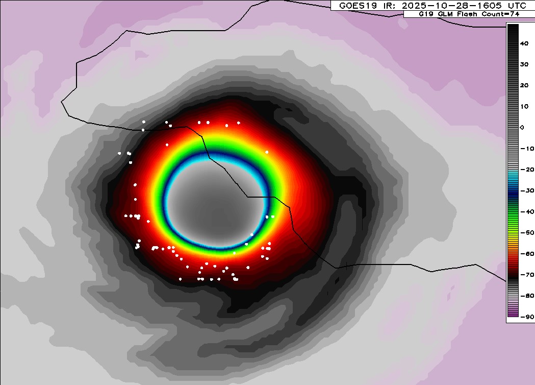
Almost there. I can see some brown in the eye. Maybe it’s from discolored seawater since it doesn’t match up w Jamaica’s coastline.

5 likes
I am NOT a professional meteorologist, so take all of my posts with a grain of salt. My opinions are mine and mine alone.

Re: NATL: MELISSA - Hurricane - Discussion: Update= 185mph/892mb at 12 PM
Historic landfall message, last time such an intense landfall happened in the Atlantic there weren't even computers to write such a message on.
Hurricane Melissa Tropical Cyclone Update
NWS National Hurricane Center Miami FL AL132025
100 PM EDT Tue Oct 28 2025
...CATEGORY 5 MELISSA MAKES LANDFALL IN JAMAICA...
...ONE OF THE MOST POWERFUL HURRICANE LANDFALLS ON RECORD IN THE
ATLANTIC BASIN...
Melissa has made landfall in southwestern Jamaica near New Hope with
estimated maximum sustained winds of 185 mph (295 km/h) and an
estimated minimum central pressure of 892 mb (26.34 inches).
THIS IS AN EXTREMELY DANGEROUS AND LIFE-THREATENING SITUATION! Do
not leave your shelter as the eye passes over, as winds will
quickly, and rapidly increase on the other side of the eye.
Residents should remain in place through the passage of these
life-threatening conditions. To protect yourself from wind, the
best thing you can do is put as many walls as possible between you
and the outside. An interior room without windows, ideally one where
you can also avoid falling trees, is the safest place you can be in
a building. You can cover yourself with a mattress and wear a
helmet for added protection.
The next position update will be provided with the intermediate
advisory at 200 PM EDT (1800 UTC).
SUMMARY OF 100 PM EDT...1700 UTC...INFORMATION
-----------------------------------------------
LOCATION...18.1N 78.0W
ABOUT 25 MI...40 KM SE OF NEGRIL JAMAICA
ABOUT 145 MI...235 KM S OF GUANTANAMO CUBA
MAXIMUM SUSTAINED WINDS...185 MPH...295 KM/H
PRESENT MOVEMENT...NNE OR 25 DEGREES AT 9 MPH...15 KM/H
MINIMUM CENTRAL PRESSURE...892 MB...26.34 INCHES
9 likes
Return to “Active Storms/Invests - Atlantic/EastPAC/CentralPAC/MED”
Who is online
Users browsing this forum: No registered users and 118 guests