https://x.com/AndyHazelton/status/1956132234642981360
The first TDR of the 2025 season is in for #Erin. There is some vertical tilt. The mid-level center seems a lot stronger than the low-level one at this point, which is interesting. I wonder if the 700-hPa jet from the SAL surge is projecting onto the circulation here?
ATL: ERIN - Hurricane - Discussion
Moderators: hurricanetrack, S2k Moderators

The posts in this forum are NOT official forecasts and should not be used as such. They are just the opinion of the poster and may or may not be backed by sound meteorological data. They are NOT endorsed by any professional institution or STORM2K. For official information, please refer to products from the National Hurricane Center and National Weather Service.

-
ConvergenceZone
.gif)
- Category 5

- Posts: 5197
- Joined: Fri Jul 29, 2005 1:40 am
- Location: Northern California
Re: ATL: ERIN - Tropical Storm - Discussion: TS Watch issued for Northern Leewards
So glad this system won't have a lot of time in the gulf. I can't imagine how the situation would have been completely different if it had a lot of time to get its act together. Hopefully the rain won't be too horrible and it will move out quick.
1 likes
-
SpaceCowboy
- Tropical Wave

- Posts: 3
- Joined: Sun Oct 06, 2024 10:31 am
Re: ATL: ERIN - Tropical Storm - Discussion: TS Watch issued for Northern Leewards
Am I the only person that feels like none of the models (not the actual data being collected but the forecast models and trajectories) are completely out of wack?
I am no meteorologist like half of you, and have even less formal education or study than all of you lol… but from 31 years experience of hurricanes, this one is really shaping out weird. And for some reason I can’t fight the gut feeling that provided the data collected today, either something isn’t being said (or projected), and this thing might smack right into somewhere on the east coast somewhere north of Broward or up in NC near MB.
I am no meteorologist like half of you, and have even less formal education or study than all of you lol… but from 31 years experience of hurricanes, this one is really shaping out weird. And for some reason I can’t fight the gut feeling that provided the data collected today, either something isn’t being said (or projected), and this thing might smack right into somewhere on the east coast somewhere north of Broward or up in NC near MB.
2 likes
-
StormWeather

- Category 1

- Posts: 285
- Joined: Wed Jun 05, 2024 2:34 pm
Re: ATL: ERIN - Tropical Storm - Discussion: TS Watch issued for Northern Leewards
ConvergenceZone wrote:So glad this system won't have a lot of time in the gulf. I can't imagine how the situation would have been completely different if it had a lot of time to get its act together. Hopefully the rain won't be too horrible and it will move out quick.
I think you meant to post this in the 98L thread.
3 likes
Just an average cyclone tracker
The posts in this forum are NOT official forecasts and should not be used as such. They are just the opinion of the poster and may or may not be backed by sound meteorological data. They are NOT endorsed by any professional institution or storm2k.org. For official information, please refer to the NHC and NWS products
The posts in this forum are NOT official forecasts and should not be used as such. They are just the opinion of the poster and may or may not be backed by sound meteorological data. They are NOT endorsed by any professional institution or storm2k.org. For official information, please refer to the NHC and NWS products
-
galaxy401

- Category 5
- Posts: 2422
- Age: 30
- Joined: Sat Aug 25, 2012 9:04 pm
- Location: Casa Grande, Arizona
Re: ATL: ERIN - Tropical Storm - Discussion
Almost the first hurricane of the season.
BULLETIN
Tropical Storm Erin Intermediate Advisory Number 14A
NWS National Hurricane Center Miami FL AL052025
800 PM AST Thu Aug 14 2025
...NOAA AIRCRAFT DATA INDICATES THAT ERIN IS NEAR HURRICANE
STRENGTH...
SUMMARY OF 800 PM AST...0000 UTC...INFORMATION
----------------------------------------------
LOCATION...16.9N 51.9W
ABOUT 745 MI...1195 KM E OF THE NORTHERN LEEWARD ISLANDS
MAXIMUM SUSTAINED WINDS...70 MPH...110 KM/H
PRESENT MOVEMENT...W OR 280 DEGREES AT 17 MPH...28 KM/H
MINIMUM CENTRAL PRESSURE...999 MB...29.50 INCHES
5 likes
Got my eyes on moving right into Hurricane Alley: Florida.


Re: ATL: ERIN - Tropical Storm - Discussion
https://x.com/cyclonicwx/status/1956141089930248199
This pass #Erin's 700mb winds corresponded quite a bit more with the pressure minimum. Either getting less tilted, or the center is elongated (reforming), and they passed an axis of it
Would mean reforming towards where the MLC is, so more like WSW. Hard to say if that's exactly what's happening though
1 likes


Re: ATL: ERIN - Tropical Storm - Discussion
Subjective and objective satellite estimates for Erin are now at or above T4.0. Between that and the observed FL winds (& the possibility that they could be undersampled), it's possible this will be Hurricane Erin on the next full advisory (3z). Even if the NHC doesn't make that call, it would take a dramatic halt to the current strengthening trend for this not to outpace the 24h forecast point from earlier this evening.
3 likes
-
cheezyWXguy

- Category 5
- Posts: 6117
- Joined: Mon Feb 13, 2006 12:29 am
- Location: Dallas, TX
Re: ATL: ERIN - Tropical Storm - Discussion: TS Watch issued for Northern Leewards
BobHarlem wrote: https://x.com/AndyHazelton/status/1956132234642981360
The first TDR of the 2025 season is in for #Erin. There is some vertical tilt. The mid-level center seems a lot stronger than the low-level one at this point, which is interesting. I wonder if the 700-hPa jet from the SAL surge is projecting onto the circulation here?
I was just thinking about what erin would look like under the hood on radar before I saw this, as satellite still gives the impression that it’s fighting some mid-level shear from the northeast. Whether erin officially makes it to hurricane status in the near term or not, I expect some structural changes over the next day or so as the shear gradually relaxes and vertical alignment occurs. Probably won’t strengthen a lot until that process completes, but regardless erin seems to be on schedule toward eventually becoming a very formidable hurricane.
1 likes
-
CrazyC83
- Professional-Met

- Posts: 34043
- Joined: Tue Mar 07, 2006 11:57 pm
- Location: Deep South, for the first time!
Re: ATL: ERIN - Tropical Storm - Discussion
The center seems to be farther north than first anticipated - around 17.2N. Could that have been a reformation that could have issues farther down the line?
0 likes
-
Sciencerocks
- Category 5
- Posts: 9256
- Age: 39
- Joined: Thu Jul 06, 2017 1:51 am

-
StormWeather
- Category 1
- Posts: 285
- Joined: Wed Jun 05, 2024 2:34 pm
Re: ATL: ERIN - Tropical Storm - Discussion
New forecast calls for 115 kts (A category 4)
2 likes
Just an average cyclone tracker
The posts in this forum are NOT official forecasts and should not be used as such. They are just the opinion of the poster and may or may not be backed by sound meteorological data. They are NOT endorsed by any professional institution or storm2k.org. For official information, please refer to the NHC and NWS products
The posts in this forum are NOT official forecasts and should not be used as such. They are just the opinion of the poster and may or may not be backed by sound meteorological data. They are NOT endorsed by any professional institution or storm2k.org. For official information, please refer to the NHC and NWS products

Re: ATL: ERIN - Tropical Storm - Discussion
CrazyC83 wrote:The center seems to be farther north than first anticipated - around 17.2N. Could that have been a reformation that could have issues farther down the line?
That's interesting and seems to match up with what looked to me like a bit of a northwestward "stair-step". So, firstly... this is one really tiny but also vigorous core. This leads me to draw a couple takeaways. I think that such a small core system such as Erin when over significantly warm SST water, and small anticyclone overhead could fuel RI well surpassing present NHC forecasts. Erin being quite the small envelope also leads me to think she'll be all the quicker to react to subtle steering changes (whatever that may translate into). I think she'll display a range of pulsating intensity within relative short spans of time, dependant on upper level conditions and short bouts of intense convection that may temporarily mitigate light to moderate shear.
I am pondering the notion of that forecast upper high to develop North of Hispanola having some influence in the mid term steering (assuming a robust and vertically developed system were in position to partially respond to a 300-400mb steering influence).
0 likes
Andy D
(For official information, please refer to the NHC and NWS products.)
(For official information, please refer to the NHC and NWS products.)
Re: ATL: ERIN - Tropical Storm - Discussion
StormWeather wrote:New forecast calls for 115 kts (A category 4)
Ha ha ha, naturally that had to update before I could hit the send button minutes ago
1 likes
Andy D
(For official information, please refer to the NHC and NWS products.)
(For official information, please refer to the NHC and NWS products.)

Re: ATL: ERIN - Tropical Storm - Discussion
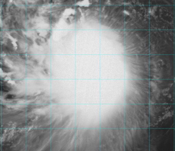
Just based on this beautiful spiked outflow in the east and southern quadrants--- this thing is kicking butt.
2 likes
List of 79 tropical cyclones intercepted by Richard Horodner:
http://www.canebeard.com/page/page/572246.htm
former storm2k screenname Beoumont 2009+
http://www.canebeard.com/page/page/572246.htm
former storm2k screenname Beoumont 2009+
-
Kingarabian

- S2K Supporter

- Posts: 16063
- Joined: Sat Aug 08, 2009 3:06 am
- Location: Honolulu, Hawaii
Re: ATL: ERIN - Tropical Storm - Discussion
canebeard wrote:Just based on this beautiful spiked outflow in the east and southern quadrants--- this thing is kicking butt.
[url]https://i.postimg.cc/T18kzX81/Screenshot-2025-08-14-10-46-32-PM.png [/url]
Thats actually a cold cast cover. Meaning it has alignment issues at the mid and lower levels and is affected by shear. Typically means that intensity will taper off until this scene type is gone.
3 likes
RIP Kobe Bryant
-
cycloneye

- Admin

- Posts: 146058
- Age: 69
- Joined: Thu Oct 10, 2002 10:54 am
- Location: San Juan, Puerto Rico
Re: ATL: ERIN - Tropical Storm - Discussion
Kingarabian wrote:canebeard wrote:Just based on this beautiful spiked outflow in the east and southern quadrants--- this thing is kicking butt.
[url]https://i.postimg.cc/T18kzX81/Screenshot-2025-08-14-10-46-32-PM.png [/url]
Thats actually a cold cast cover. Meaning it has alignment issues at the mid and lower levels and is affected by shear. Typically means that intensity will taper off until this scene type is gone.
We will know much more about the structure of Erin in the overnight hours as the Air Force plane does the mission.
0 likes
Visit the Caribbean-Central America Weather Thread where you can find at first post web cams,radars
and observations from Caribbean basin members Click Here
and observations from Caribbean basin members Click Here
Re: ATL: ERIN - Tropical Storm - Discussion
canebeard wrote:Just based on this beautiful spiked outflow in the east and southern quadrants--- this thing is kicking butt.
[url]https://i.postimg.cc/T18kzX81/Screenshot-2025-08-14-10-46-32-PM.png [/url]
That's clearly being sheared, the outflow is constrained on the east side.
1 likes
-
cheezyWXguy
- Category 5
- Posts: 6117
- Joined: Mon Feb 13, 2006 12:29 am
- Location: Dallas, TX
Re: ATL: ERIN - Tropical Storm - Discussion
zzzh wrote:canebeard wrote:Just based on this beautiful spiked outflow in the east and southern quadrants--- this thing is kicking butt.
[url]https://i.postimg.cc/T18kzX81/Screenshot-2025-08-14-10-46-32-PM.png [/url]
That's clearly being sheared, the outflow is constrained on the east side.
Yep, the upper level outflow looks nice but you can tell from the lack of banding features on the eastern side and the small cloud filaments streaming westward that it’s still being undercut by some mid level shear. This isn’t unexpected though, faster intensification doesn’t really look to start until tomorrow night and beyond. Anything earlier than that would be faster than anticipated from what I can tell.
0 likes
Re: ATL: ERIN - Tropical Storm - Discussion
The CCC seems to be dissipating now. Once it's gone we should see some hot towers rotating.
1 likes
Return to “Active Storms/Invests - Atlantic/EastPAC/CentralPAC/MED”
Who is online
Users browsing this forum: Google Adsense [Bot] and 74 guests