EPAC: KIKO - Hurricane - Discussion

Current storms and invests:

Moderators: hurricanetrack, S2k Moderators


The posts in this forum are NOT official forecasts and should not be used as such. They are just the opinion of the poster and may or may not be backed by sound meteorological data. They are NOT endorsed by any professional institution or STORM2K. For official information, please refer to products from the National Hurricane Center and National Weather Service.

Help Support Storm2K
Message
Author
TomballEd
Category 3
Category 3
Posts: 882
Age: 61
Joined: Wed Aug 16, 2023 4:52 pm
Location: Spring/Klein area, not Tomball

Re: EPAC: KIKO - Tropical Storm - Discussion

#41 Postby TomballEd » Sun Aug 31, 2025 2:50 pm

Kingarabian wrote:12z Euro with very noticeable SW dip. Could see a significant system out of this.

https://i.postimg.cc/y8m0qrYC/ec-fast-mslpa-Norm-cpac-fh48-240.gif

Pay no attention to the Euro/CMC/ICON initial intensities for Kiko as it nears 140W. Models struggle with intensity in this area.


The Big Island is the Pacific version of Hispaniola, it shreds storms that hit the island and even weakens near miss storms. It seems to happen every time a TC gets close to Hawaii, and is after the storm has passed the coolest SSTs and water temps have started to rise again.
1 likes   

User avatar
Kingarabian
S2K Supporter
S2K Supporter
Posts: 16146
Joined: Sat Aug 08, 2009 3:06 am
Location: Honolulu, Hawaii

Re: EPAC: KIKO - Tropical Storm - Discussion

#42 Postby Kingarabian » Sun Aug 31, 2025 2:52 pm

TomballEd wrote:
Kingarabian wrote:12z Euro with very noticeable SW dip. Could see a significant system out of this.

https://i.postimg.cc/y8m0qrYC/ec-fast-mslpa-Norm-cpac-fh48-240.gif

Pay no attention to the Euro/CMC/ICON initial intensities for Kiko as it nears 140W. Models struggle with intensity in this area.


The Big Island is the Pacific version of Hispaniola, it shreds storms that hit the island and even weakens near miss storms. It seems to happen every time a TC gets close to Hawaii, and is after the storm has passed the coolest SSTs and water temps have started to rise again.


Models do a lot of weird stuff when they have a solution that shows some type of TC interaction with the Big Island.
0 likes   
RIP Kobe Bryant

User avatar
Kingarabian
S2K Supporter
S2K Supporter
Posts: 16146
Joined: Sat Aug 08, 2009 3:06 am
Location: Honolulu, Hawaii

Re: EPAC: KIKO - Tropical Storm - Discussion

#43 Postby Kingarabian » Sun Aug 31, 2025 2:52 pm

Dual outflow channels on visible.

Image
2 likes   
RIP Kobe Bryant

User avatar
Kingarabian
S2K Supporter
S2K Supporter
Posts: 16146
Joined: Sat Aug 08, 2009 3:06 am
Location: Honolulu, Hawaii

Re: EPAC: KIKO - Tropical Storm - Discussion

#44 Postby Kingarabian » Sun Aug 31, 2025 2:55 pm

12z Euro ensembles have some strong members.

Image
1 likes   
RIP Kobe Bryant

User avatar
cycloneye
Admin
Admin
Posts: 146429
Age: 69
Joined: Thu Oct 10, 2002 10:54 am
Location: San Juan, Puerto Rico

Re: EPAC: KIKO - Tropical Storm - Discussion

#45 Postby cycloneye » Sun Aug 31, 2025 3:50 pm

BULLETIN
Tropical Storm Kiko Advisory Number 3
NWS National Hurricane Center Miami FL EP112025
1100 AM HST Sun Aug 31 2025

...KIKO MOVING WESTWARD WITH LITTLE CHANGE IN STRENGTH...


SUMMARY OF 1100 AM HST...2100 UTC...INFORMATION
-----------------------------------------------
LOCATION...14.4N 124.0W
ABOUT 1090 MI...1760 KM WSW OF THE SOUTHERN TIP OF BAJA CALIFORNIA
MAXIMUM SUSTAINED WINDS...40 MPH...65 KM/H
PRESENT MOVEMENT...W OR 270 DEGREES AT 9 MPH...15 KM/H
MINIMUM CENTRAL PRESSURE...1006 MB...29.71 INCHES


Tropical Storm Kiko Discussion Number 3
NWS National Hurricane Center Miami FL EP112025
1100 AM HST Sun Aug 31 2025

Kiko has changed little in organization during the past few hours,
with a broad curved convective band wrapping around the western
side of the cyclone. Recent ASCAT overpasses did not show
tropical-storm force winds. However, there may be sampling issues
at work since the central core of Kiko is small. Satellite
intensity estimates are in the 35-45 kt range, and the initial
intensity is held at 35 kt in deference to the scatterometer data.
The scatterometer data and conventional imagery suggest the
circulation center is elongated east-west with multiple cloud
swirls present.

The initial motion remains 270/8 kt. Kiko is on the south side of
a deep-layer ridge that covers the tropical Pacific between
120W-155W, and this feature is expected to persist for the next
several days. This should cause Kiko to move westward or just south
of westward through the forecast period. While the track guidance
generally agrees on the direction of motion, there is a
considerable spread in forward speed with the faster UKMET/ECMWF
being several hundred miles west of the slower GFS by 120 h. The
new forecast track splits this speed difference, and it lies just
north of the consensus models. The new forecast is a bit south
of and slower than the previous forecast.

Kiko is expected to encounter generally light vertical shear while
it moves over sea surface temperatures that are around 27C. After
72 h, the cyclone is likely to move into a drier air mass that
could inhibit strengthening despite the other favorable conditions.
Based on this, the intensity forecast shows 72 h of strengthening
followed by little change in strength at 96 and 120 h. There are
two uncertainties in this forecast. First, the rapid
intensification indices of the SHIPS model are notably above their
climatological norms, and that combined with Kiko's small core
suggests that a period of rapid intensification could occur during
the next 72 h. Second, as mentioned earlier any deviation of the
track slightly to the right of the forecast path could place the
system over cooler waters that would slow or stop strengthening. The
new intensity forecast is a little stronger than the previous
forecast, and it lies near the intensity consensus.


FORECAST POSITIONS AND MAX WINDS

INIT 31/2100Z 14.4N 124.0W 35 KT 40 MPH
12H 01/0600Z 14.3N 125.2W 40 KT 45 MPH
24H 01/1800Z 14.2N 126.9W 50 KT 60 MPH
36H 02/0600Z 14.1N 128.5W 60 KT 70 MPH
48H 02/1800Z 14.1N 130.2W 70 KT 80 MPH
60H 03/0600Z 14.0N 131.9W 75 KT 85 MPH
72H 03/1800Z 14.0N 133.7W 80 KT 90 MPH
96H 04/1800Z 14.0N 137.6W 80 KT 90 MPH
120H 05/1800Z 14.1N 141.3W 80 KT 90 MPH

$$
Forecaster Beven
0 likes   
Visit the Caribbean-Central America Weather Thread where you can find at first post web cams,radars
and observations from Caribbean basin members Click Here

User avatar
cycloneye
Admin
Admin
Posts: 146429
Age: 69
Joined: Thu Oct 10, 2002 10:54 am
Location: San Juan, Puerto Rico

Re: EPAC: KIKO - Tropical Storm - Discussion

#46 Postby cycloneye » Sun Aug 31, 2025 4:50 pm

That convective burst should give it a boost to begin to intensify.

Image
4 likes   
Visit the Caribbean-Central America Weather Thread where you can find at first post web cams,radars
and observations from Caribbean basin members Click Here

User avatar
cycloneye
Admin
Admin
Posts: 146429
Age: 69
Joined: Thu Oct 10, 2002 10:54 am
Location: San Juan, Puerto Rico

Re: EPAC: KIKO - Tropical Storm - Discussion

#47 Postby cycloneye » Sun Aug 31, 2025 8:09 pm

EP, 11, 2025090100, , BEST, 0, 145N, 1242W, 40, 1004, TS


Image

Image
0 likes   
Visit the Caribbean-Central America Weather Thread where you can find at first post web cams,radars
and observations from Caribbean basin members Click Here

User avatar
cycloneye
Admin
Admin
Posts: 146429
Age: 69
Joined: Thu Oct 10, 2002 10:54 am
Location: San Juan, Puerto Rico

Re: EPAC: KIKO - Tropical Storm - Discussion

#48 Postby cycloneye » Sun Aug 31, 2025 9:36 pm

BULLETIN
Tropical Storm Kiko Advisory Number 4
NWS National Hurricane Center Miami FL EP112025
500 PM HST Sun Aug 31 2025

...KIKO EXPECTED TO STEADILY STRENGTHEN DURING THE NEXT FEW DAYS...


SUMMARY OF 500 PM HST...0300 UTC...INFORMATION
----------------------------------------------
LOCATION...14.5N 124.6W
ABOUT 1120 MI...1805 KM WSW OF THE SOUTHERN TIP OF BAJA CALIFORNIA
MAXIMUM SUSTAINED WINDS...45 MPH...75 KM/H
PRESENT MOVEMENT...W OR 270 DEGREES AT 9 MPH...15 KM/H
MINIMUM CENTRAL PRESSURE...1004 MB...29.65 INCHES


Tropical Storm Kiko Discussion Number 4
NWS National Hurricane Center Miami FL EP112025
500 PM HST Sun Aug 31 2025

Kiko is gradually organizing. The tropical storm is producing bands
of deep convection near the center and on its south side. The
latest satellite intensity estimates are generally between 40 and
45 kt, and based on that data, the initial wind speed is nudged
upward to 40 kt.

Kiko is moving westward at 8 kt. An expansive mid-level ridge
situated across the subtropical eastern and central Pacific should
keep Kiko on a westward, or perhaps even a little south of due west,
path throughout the week. The models agree on the overall synoptic
pattern, but there are notable differences in their predicted
forward speeds. The NHC track forecast lies near the faster end of
the model guidance, in best agreement with the HCCA and EMXI models.
Kiko is likely to cross into the central Pacific basin in 4 to 5
days.

While the wind shear around Kiko is expected to be relatively low
over the next several days, the surrounding moisture and SSTs along
its forecast track are just marginally favorable for the storm.
There are significant differences in the intensity model solutions
that vary from Kiko remaining a tropical storm to becoming a major
hurricane. Since Kiko appears to be developing an inner core, it
seems likely that the storm should strengthen steadily over the next
few days. The NHC intensity forecast is a little higher than the
previous one and roughly near the middle of the guidance envelope.

Kiko is currently a compact system. Although it is forecast to get
larger, the model guidance suggests that it will likely be on the
smaller side through the week.


FORECAST POSITIONS AND MAX WINDS

INIT 01/0300Z 14.5N 124.6W 40 KT 45 MPH
12H 01/1200Z 14.4N 125.8W 50 KT 60 MPH
24H 02/0000Z 14.3N 127.4W 60 KT 70 MPH
36H 02/1200Z 14.2N 129.0W 70 KT 80 MPH
48H 03/0000Z 14.1N 130.6W 75 KT 85 MPH
60H 03/1200Z 14.1N 132.4W 80 KT 90 MPH
72H 04/0000Z 14.1N 134.2W 85 KT 100 MPH
96H 05/0000Z 14.1N 138.1W 85 KT 100 MPH
120H 06/0000Z 14.5N 141.8W 85 KT 100 MPH

$$
Forecaster Cangialosi
0 likes   
Visit the Caribbean-Central America Weather Thread where you can find at first post web cams,radars
and observations from Caribbean basin members Click Here

User avatar
cycloneye
Admin
Admin
Posts: 146429
Age: 69
Joined: Thu Oct 10, 2002 10:54 am
Location: San Juan, Puerto Rico

Re: EPAC: KIKO - Tropical Storm - Discussion

#49 Postby cycloneye » Mon Sep 01, 2025 4:52 am

BULLETIN
Tropical Storm Kiko Advisory Number 5
NWS National Hurricane Center Miami FL EP112025
1100 PM HST Sun Aug 31 2025

...KIKO HOLDING STEADY AS IT CONTINUES WESTWARD...


SUMMARY OF 1100 PM HST...0900 UTC...INFORMATION
-----------------------------------------------
LOCATION...14.1N 125.5W
ABOUT 1185 MI...1910 KM WSW OF THE SOUTHERN TIP OF BAJA CALIFORNIA
MAXIMUM SUSTAINED WINDS...45 MPH...75 KM/H
PRESENT MOVEMENT...W OR 265 DEGREES AT 8 MPH...13 KM/H
MINIMUM CENTRAL PRESSURE...1004 MB...29.65 INCHES


Tropical Storm Kiko Discussion Number 5
NWS National Hurricane Center Miami FL EP112025
1100 PM HST Sun Aug 31 2025

Kiko remains a compact tropical cyclone. Satellite imagery shows
deep convection developing over the center with cloud top
temperatures around -80 C and curved bands wrapping into the
circulation. Subjective Dvorak current intensity estimates from TAFB
and SAB remain at 3.0/45 kt, while objective estimates range from 35
to 45 kt. A 0536 UTC ASCAT-B pass indicated peak winds near 34 kt on
the northern side of the storm. Based on a blend of these data, the
initial intensity is held at 40 kt for this advisory.

Kiko is now moving just south of due west, or 265/7 kt, steered by a
mid-level subtropical ridge located to the north. This general
motion is expected to continue for the next 36 hours, followed by a
more westward track through about 96 hours. Thereafter, the cyclone
should gradually turn toward the west-northwest as it crosses into
the central Pacific basin between days 4 and 5 due to a potential
weakness in the subtropical ridge far north of the Hawaiian Islands.
While the overall synoptic pattern is consistent, there remains
considerable spread in the along-track speed among the models. The
NHC track forecast is nearly identical to the previous one and leans
heavily on a blend of the HCCA and EMXI aids, which lie on the
faster side of the guidance envelope.

Light vertical wind shear and modest mid-level moisture should
support strengthening during the next few days, although Kiko’s
forecast track keeps it near the 26 C isotherm and into a somewhat
drier environment after midweek. Based on the latest SHIPS guidance
and the cyclone’s small, compact core, a period of more rapid
intensification cannot be ruled out through midweek. Kiko is
forecast to become a hurricane within 36 hours and peak at 85 kt in
72 hours, which is near the higher end of the guidance envelope.
Beyond that time, any increase in latitude would likely bring the
storm over cooler waters, inhibiting any additional significant
strengthening.


FORECAST POSITIONS AND MAX WINDS

INIT 01/0900Z 14.1N 125.5W 40 KT 45 MPH
12H 01/1800Z 13.9N 126.7W 50 KT 60 MPH
24H 02/0600Z 13.7N 128.2W 60 KT 70 MPH
36H 02/1800Z 13.5N 129.6W 70 KT 80 MPH
48H 03/0600Z 13.5N 131.2W 75 KT 85 MPH
60H 03/1800Z 13.5N 132.9W 80 KT 90 MPH
72H 04/0600Z 13.6N 134.7W 85 KT 100 MPH
96H 05/0600Z 13.9N 138.3W 85 KT 100 MPH
120H 06/0600Z 14.4N 141.8W 85 KT 100 MPH

$$
Forecaster Gibbs (CPHC)
0 likes   
Visit the Caribbean-Central America Weather Thread where you can find at first post web cams,radars
and observations from Caribbean basin members Click Here

User avatar
cycloneye
Admin
Admin
Posts: 146429
Age: 69
Joined: Thu Oct 10, 2002 10:54 am
Location: San Juan, Puerto Rico

Re: EPAC: KIKO - Tropical Storm - Discussion

#50 Postby cycloneye » Mon Sep 01, 2025 7:55 am

A. 11E (KIKO)

B. 01/1200Z

C. 14.0N

D. 125.9W

E. THREE/GOES-W

F. T4.0/4.0

G. IR/EIR/PRXY/GMI

H. REMARKS...11/10 BANDING RESULTS IN A DT OF 4.0. THE MET AND PT ARE
4.0. THE FT IS BASED ON THE DT.

I. ADDL POSITIONS

01/1014Z 14.0N 125.7W GMI


...MONAGHAN
0 likes   
Visit the Caribbean-Central America Weather Thread where you can find at first post web cams,radars
and observations from Caribbean basin members Click Here

User avatar
cycloneye
Admin
Admin
Posts: 146429
Age: 69
Joined: Thu Oct 10, 2002 10:54 am
Location: San Juan, Puerto Rico

Re: EPAC: KIKO - Tropical Storm - Discussion

#51 Postby cycloneye » Mon Sep 01, 2025 7:58 am

0 likes   
Visit the Caribbean-Central America Weather Thread where you can find at first post web cams,radars
and observations from Caribbean basin members Click Here

User avatar
cycloneye
Admin
Admin
Posts: 146429
Age: 69
Joined: Thu Oct 10, 2002 10:54 am
Location: San Juan, Puerto Rico

Re: EPAC: KIKO - Tropical Storm - Discussion

#52 Postby cycloneye » Mon Sep 01, 2025 8:01 am

Doing RI.

Image
0 likes   
Visit the Caribbean-Central America Weather Thread where you can find at first post web cams,radars
and observations from Caribbean basin members Click Here

User avatar
Kingarabian
S2K Supporter
S2K Supporter
Posts: 16146
Joined: Sat Aug 08, 2009 3:06 am
Location: Honolulu, Hawaii

Re: EPAC: KIKO - Tropical Storm - Discussion

#53 Postby Kingarabian » Mon Sep 01, 2025 8:38 am

Cyan ring present on a 2 hour old AMSR2 pass.

Image
Image
4 likes   
RIP Kobe Bryant

User avatar
Kingarabian
S2K Supporter
S2K Supporter
Posts: 16146
Joined: Sat Aug 08, 2009 3:06 am
Location: Honolulu, Hawaii

Re: EPAC: KIKO - Tropical Storm - Discussion

#54 Postby Kingarabian » Mon Sep 01, 2025 8:39 am

Likely a hurricane now. Would bump it to 60kts at least.
0 likes   
RIP Kobe Bryant

User avatar
cycloneye
Admin
Admin
Posts: 146429
Age: 69
Joined: Thu Oct 10, 2002 10:54 am
Location: San Juan, Puerto Rico

Re: EPAC: KIKO - Tropical Storm - Discussion

#55 Postby cycloneye » Mon Sep 01, 2025 9:41 am

They went with 50kt.

BULLETIN
Tropical Storm Kiko Advisory Number 6
NWS National Hurricane Center Miami FL EP112025
500 AM HST Mon Sep 01 2025

...KIKO FORECAST TO RAPIDLY STRENGTHEN INTO A HURRICANE BY
TUESDAY...


SUMMARY OF 500 AM HST...1500 UTC...INFORMATION
----------------------------------------------
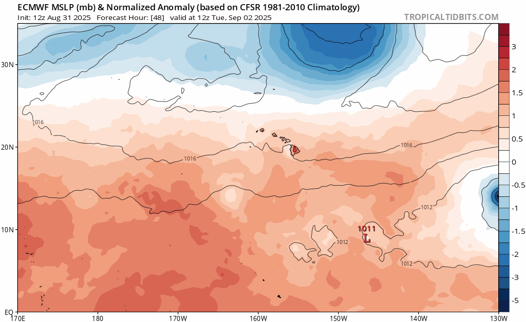
LOCATION...14.0N 126.3W
ABOUT 1235 MI...1990 KM WSW OF THE SOUTHERN TIP OF BAJA CALIFORNIA
MAXIMUM SUSTAINED WINDS...60 MPH...95 KM/H
PRESENT MOVEMENT...W OR 265 DEGREES AT 8 MPH...13 KM/H
MINIMUM CENTRAL PRESSURE...998 MB...29.47 INCHES


Tropical Storm Kiko Discussion Number 6
NWS National Hurricane Center Miami FL EP112025
500 AM HST Mon Sep 01 2025

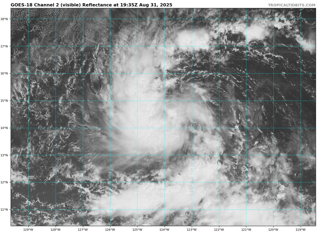
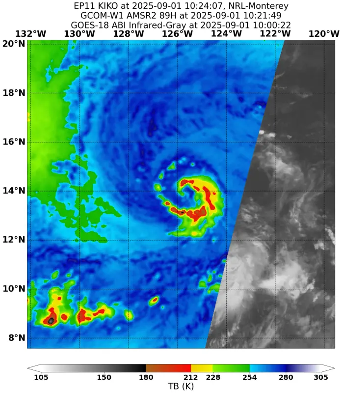
Kiko has intensified overnight and remains a compact storm. A timely
GMI microwave pass revealed a closed cyan ring around the center in
the 37-GHz image. The system’s compact size and improving core
structure suggest that the inner core is consolidating, which often
precedes rapid intensification. Subjective Dvorak intensity
estimates from TAFB are 3.0/45 kt and from SAB are 4.0/64 kt, while
objective estimates have increased into the 40–50 kt range. Given
this range of data and the improving satellite presentation, the
initial intensity is set at 50 kt for this advisory.

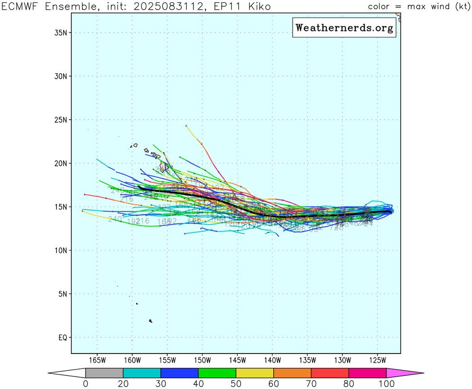
Kiko is moving just south of due west, or 265/7 kt, steered by a
mid-level subtropical ridge to the north. This general motion is
expected to continue for the next 36 hours, followed by a more
westward track through about 72 hours. Thereafter, the cyclone
should gradually begin to turn toward the west-northwest as it
crosses into the central Pacific basin between days 4 and 5 due to a
potential weakness in the subtropical ridge far north of the
Hawaiian Islands. While the overall synoptic pattern is consistent,
there remains considerable spread in along-track speed among the
models. The NHC forecast is nearly identical to the previous one and
continues to lean heavily on a blend of the HCCA and EMXI aids,
which are near the faster side of the guidance envelope.

Despite somewhat drier mid-level conditions along its forecast
track, the combination of light vertical wind shear, warm sea
surface temperatures, and Kiko’s small compact core should allow for
strengthening in the short term. Rapid intensification probabilities
from the SHIPS guidance have increased over the past 24 hours, with
around a 30–40 percent chance of a 30-kt increase in the next 24
hours. As a result, the official forecast reflects the potential for
this during the first 24 hours, placing the intensity near the upper
end of the guidance envelope during that period. Kiko’s intensity is
forecast to peak near 85 kt in about 48 hours and then hold steady
through day 5, which is near the middle to upper end of the guidance
envelope.


FORECAST POSITIONS AND MAX WINDS

INIT 01/1500Z 14.0N 126.3W 50 KT 60 MPH
12H 02/0000Z 13.8N 127.4W 60 KT 70 MPH
24H 02/1200Z 13.6N 128.8W 75 KT 85 MPH
36H 03/0000Z 13.5N 130.1W 80 KT 90 MPH
48H 03/1200Z 13.5N 131.7W 85 KT 100 MPH
60H 04/0000Z 13.6N 133.3W 85 KT 100 MPH
72H 04/1200Z 13.7N 135.0W 85 KT 100 MPH
96H 05/1200Z 14.0N 138.3W 85 KT 100 MPH
120H 06/1200Z 14.8N 141.7W 85 KT 100 MPH

$$
Forecaster Gibbs (CPHC)
0 likes   
Visit the Caribbean-Central America Weather Thread where you can find at first post web cams,radars
and observations from Caribbean basin members Click Here

User avatar
Yellow Evan
Professional-Met
Professional-Met
Posts: 16174
Age: 27
Joined: Fri Jul 15, 2011 12:48 pm
Location: Henderson, Nevada/Honolulu, HI
Contact:

Re: EPAC: KIKO - Tropical Storm - Discussion

#56 Postby Yellow Evan » Mon Sep 01, 2025 1:18 pm

Significant long tracked hurricane likely given high SSTs and low to moderate easterly shear as suggested by the past few days of hurricane model runs. Not sure why forecast intensity is only 85 knots after tau 48.
0 likes   

TomballEd
Category 3
Category 3
Posts: 882
Age: 61
Joined: Wed Aug 16, 2023 4:52 pm
Location: Spring/Klein area, not Tomball

Re: EPAC: KIKO - Tropical Storm - Discussion

#57 Postby TomballEd » Mon Sep 01, 2025 1:31 pm

It obviously weakens as it approaches Hawaii on almost most of the members but I'd suspect even a TS with the topography of Hawaii would support some very heavy rains. Surfers should see nice waves well ahead of the storm.

I've only been to Oahu (Pearl Harbor many times) but even that island has some terrain.

Image
1 likes   

User avatar
cycloneye
Admin
Admin
Posts: 146429
Age: 69
Joined: Thu Oct 10, 2002 10:54 am
Location: San Juan, Puerto Rico

Re: EPAC: KIKO - Tropical Storm - Discussion

#58 Postby cycloneye » Mon Sep 01, 2025 1:44 pm

A. 11E (KIKO)

B. 01/1800Z

C. 13.8N

D. 126.4W

E. THREE/GOES-W

F. T4.0/4.0

G. IR/EIR/VIS/SSMIS

H. REMARKS...10.5/10 BANDING RESULTS IN A DT OF 4.0. THE MET AND PT
ARE 4.0. THE FT IS BASED ON THE DT.

I. ADDL POSITIONS

01/1451Z 13.8N 126.2W SSMIS


...MONAGHAN
0 likes   
Visit the Caribbean-Central America Weather Thread where you can find at first post web cams,radars
and observations from Caribbean basin members Click Here

User avatar
Kingarabian
S2K Supporter
S2K Supporter
Posts: 16146
Joined: Sat Aug 08, 2009 3:06 am
Location: Honolulu, Hawaii

Re: EPAC: KIKO - Tropical Storm - Discussion

#59 Postby Kingarabian » Mon Sep 01, 2025 1:48 pm

TomballEd wrote:It obviously weakens as it approaches Hawaii on almost most of the members but I'd suspect even a TS with the topography of Hawaii would support some very heavy rains. Surfers should see nice waves well ahead of the storm.

I've only been to Oahu (Pearl Harbor many times) but even that island has some terrain.

https://i.imgur.com/nd0jkeJ.png


Angle of approach will dictate intensity. Also how strong it gets between now and before it reaches cooler waters will be key.
1 likes   
RIP Kobe Bryant

User avatar
cycloneye
Admin
Admin
Posts: 146429
Age: 69
Joined: Thu Oct 10, 2002 10:54 am
Location: San Juan, Puerto Rico

Re: EPAC: KIKO - Tropical Storm - Discussion

#60 Postby cycloneye » Mon Sep 01, 2025 3:41 pm

BULLETIN
Tropical Storm Kiko Advisory Number 7
NWS National Hurricane Center Miami FL EP112025
1100 AM HST Mon Sep 01 2025

...KIKO CONTINUES TO STRENGTHEN...


SUMMARY OF 1100 AM HST...2100 UTC...INFORMATION
-----------------------------------------------
LOCATION...13.8N 126.7W
ABOUT 1265 MI...2035 KM WSW OF THE SOUTHERN TIP OF BAJA CALIFORNIA
MAXIMUM SUSTAINED WINDS...65 MPH...100 KM/H
PRESENT MOVEMENT...WSW OR 255 DEGREES AT 7 MPH...11 KM/H
MINIMUM CENTRAL PRESSURE...999 MB...29.50 INCHES


Tropical Storm Kiko Discussion Number 7
NWS National Hurricane Center Miami FL EP112025
1100 AM HST Mon Sep 01 2025

Kiko continues to gradually become better organized on conventional
satellite imagery with increasingly impressive curved banding noted
in 1-minute GOES-18 imagery. The latest subjective Dvorak estimates
range from 55-65 kt while objective intensity estimates from
UW-CIMSS continue to be in the 45-50 kt range. Based on a blend of
the data and improving appearance on satellite imagery over the last
few hours, the initial intensity is increased to 55 kt for this
advisory.

Kiko has been moving toward the west-southwest at a slightly slower
speed, with an estimated motion of 255/6 kt. A strengthening
subtropical ridge to Kiko's north should cause this general motion
to continue for the next day or so. After that time, Kiko should
turn back toward the west due to its position due south of the
strongest part of the ridge. By the end of the forecast period, a
west-northwestward motion is likely as Kiko starts to reach the
southwestern portion of the ridge's influence. There is very large
along-track spread in the guidance, meaning that there is high
uncertainty in Kiko's forward speed. The latest guidance has
trended slower. The NHC forecast is slower and a bit to the north
of the previous forecast, but not as slow as most of the latest
consensus models. This latest track forecast is fairly close to the
12Z ECMWF model.

Relatively warm ocean temperatures and light wind shear should allow
Kiko to steadily strengthen over the next couple of days. If Kiko
were to move south of the NHC forecast track, it could encounter
stronger shear in 1-2 days, as the models show stronger upper level
winds south of about 13N latitude. The other factor that
complicates the intensity forecast is the possibility that some dry
air tries to entrain into the circulation. The peak forecast
intensity has been increased a bit to show a peak of 95 kt in 60-72
hours. This is closer to the latest HCCA and high resolution
hurricane models, some of which bring Kiko to major hurricane
intensity. Late in the forecast period, some slight weakening is
possible due to slightly cooler ocean temperatures and the potential
for slightly drier and more stable air. The intensity forecast lies
near the upper end of the guidance envelope.


FORECAST POSITIONS AND MAX WINDS

INIT 01/2100Z 13.8N 126.7W 55 KT 65 MPH
12H 02/0600Z 13.7N 127.7W 65 KT 75 MPH
24H 02/1800Z 13.6N 128.9W 75 KT 85 MPH
36H 03/0600Z 13.6N 130.3W 85 KT 100 MPH
48H 03/1800Z 13.6N 131.7W 90 KT 105 MPH
60H 04/0600Z 13.8N 133.2W 95 KT 110 MPH
72H 04/1800Z 13.9N 134.8W 95 KT 110 MPH
96H 05/1800Z 14.3N 138.1W 85 KT 100 MPH
120H 06/1800Z 15.2N 141.6W 85 KT 100 MPH

$$
Forecaster Hagen
0 likes   
Visit the Caribbean-Central America Weather Thread where you can find at first post web cams,radars
and observations from Caribbean basin members Click Here


Return to “Active Storms/Invests - Atlantic/EastPAC/CentralPAC/MED”

Who is online

Users browsing this forum: No registered users and 63 guests