BULLETIN
Hurricane Lorena Advisory Number 9
NWS National Hurricane Center Miami FL EP122025
800 PM MST Wed Sep 03 2025
...LORENA A LITTLE STRONGER BUT EXPECTED TO WEAKEN QUICKLY ON
THURSDAY AND FRIDAY...
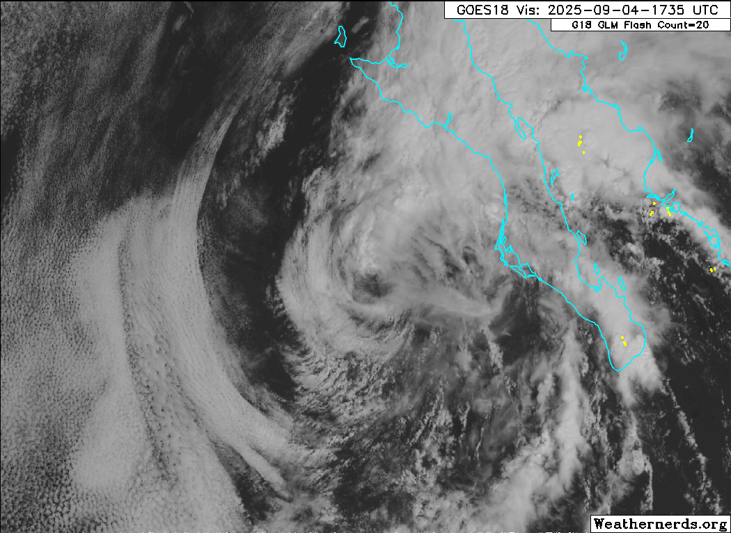
...RISK OF LIFE-THREATENING FLASH FLOODING CONTINUES FOR BAJA
CALIFORNIA SUR AND SOUTHWESTERN SONORA...
SUMMARY OF 800 PM MST...0300 UTC...INFORMATION
----------------------------------------------
LOCATION...23.4N 113.2W
ABOUT 110 MI...180 KM SSW OF CABO SAN LAZARO MEXICO
ABOUT 210 MI...340 KM W OF CABO SAN LUCAS MEXICO
MAXIMUM SUSTAINED WINDS...85 MPH...140 KM/H
PRESENT MOVEMENT...NW OR 310 DEGREES AT 12 MPH...19 KM/H
MINIMUM CENTRAL PRESSURE...981 MB...28.97 INCHES
Hurricane Lorena Discussion Number 9
NWS National Hurricane Center Miami FL EP122025
800 PM MST Wed Sep 03 2025
Objective satellite intensity estimates from UW-CIMSS (ADT,
AiDT, and SATCON) have increased by 5 to 10 kt since the Air Force
Reserve reconnaissance mission into Lorena earlier this afternoon.
Since the plane's data suggested an intensity of 70 kt at that
time, the current intensity is estimated to be about 75 kt. That
said, Lorena is probably at its peak intensity. There are already
signs in conventional and microwave satellite imagery that vertical
shear is beginning to strengthen, with a sharpening of the southern
side of the upper-level cloud pattern and some tilt of the
circulation with height. The shear is forecast to gradually
increase over the next couple of days, and Lorena will also be
moving over waters colder than 26 degrees Celsius in about 6 to 12
hours. Therefore, quick weakening is shown in the official
forecast.
Lorena continues to move toward the northwest, or 310 degrees, but
at a slightly slower 10 kt. As the cyclone moves farther into a
break in the subtropical ridge, it is expected to turn northward
and slow down further by Thursday evening, and then move only
slowly north-northeastward into the weekend. The 18z GFS run is
finally playing the same tune as much of the other guidance,
showing Lorena quickly decoupling as the shear removes its deep
convection and leaving the low-level center drifting toward the
west coast of Baja California Sur. Now that there is
near-unanimous agreement that Lorena is unlikely to move quickly
as a deep system toward northwestern Mexico, the NHC track forecast
has been slowed down significantly, blending the previous forecast
with the most recent HCCA and TVCE consensus aids. This new
forecast brings Lorena's center to the west coast of Baja
California Sur in about 48 hours as a weakening tropical cyclone,
with the system reaching the east coast of the peninsula as a
remnant low in about 60 hours. However, based on the latest GFS-
and ECMWF-based simulated satellite imagery, the transition to a
remnant low could occur earlier than that.
Even if Lorena weakens and becomes a remnant low earlier than
previously predicted, abundant moisture will continue to stream
northeastward away from the cyclone. Because of that, there is
still a significant risk of heavy rainfall and flash flooding across
portions of Baja California Sur, Sonora, and southern Arizona and
New Mexico.
Key Messages:
1. Heavy rainfall associated with Lorena will continue to impact
Baja California Sur and shift into southwestern Sonora Thursday.
This will increase the risk of life-threatening flash floods and
mudslides across northwest Mexico.
2. Moisture from Lorena will contribute to heavy rainfall concerns
across Arizona and southwest New Mexico through Saturday. Isolated
to scattered instances of flash flooding are possible across Arizona
into Saturday.
3. The center of Lorena is forecast to move parallel to, but
offshore of, the southwest coast of the Baja California Peninsula
through Thursday, and then move closer to the west-central coast of
the peninsula Thursday night and Friday. Regardless of the exact
track, tropical storm conditions are likely along portions of the
coast of Baja California Sur where a Tropical Storm Warning is in
effect. Tropical storm conditions are also possible late Friday
along the east coast of the Baja California peninsula, where a
Tropical Storm Watch is in effect.
4. Life-threatening surf and rip current conditions will affect
portions of the southern and western coasts of Baja California Sur
during the next couple of days.
FORECAST POSITIONS AND MAX WINDS
INIT 04/0300Z 23.4N 113.2W 75 KT 85 MPH
12H 04/1200Z 24.1N 113.9W 65 KT 75 MPH
24H 05/0000Z 25.0N 114.1W 55 KT 65 MPH
36H 05/1200Z 26.0N 113.8W 45 KT 50 MPH
48H 06/0000Z 27.0N 113.4W 35 KT 40 MPH
60H 06/1200Z 28.0N 113.0W 30 KT 35 MPH...POST-TROP/REMNT LOW
72H 07/0000Z 28.8N 112.9W 25 KT 30 MPH...POST-TROP/REMNT LOW
96H 08/0000Z...DISSIPATED
$$
Forecaster Berg
Visit the Caribbean-Central America Weather Thread where you can find at first post web cams,radars
and observations from Caribbean basin members
Click Here