Agree with Andy.
https://x.com/AndyHazelton/status/1963785118478225558
ATL: Ex INVEST 91L - Discussion (0/0)
Moderators: hurricanetrack, S2k Moderators

The posts in this forum are NOT official forecasts and should not be used as such. They are just the opinion of the poster and may or may not be backed by sound meteorological data. They are NOT endorsed by any professional institution or STORM2K. For official information, please refer to products from the National Hurricane Center and National Weather Service.

-
cycloneye

- Admin

- Posts: 146550
- Age: 69
- Joined: Thu Oct 10, 2002 10:54 am
- Location: San Juan, Puerto Rico
Re: ATL: INVEST 91L - Discussion (60/90)
3 likes
Visit the Caribbean-Central America Weather Thread where you can find at first post web cams,radars
and observations from Caribbean basin members Click Here
and observations from Caribbean basin members Click Here
-
AJC3

- Admin
- Posts: 4043
- Age: 61
- Joined: Tue Aug 31, 2004 7:04 pm
- Location: Ballston Spa, New York
- Contact:
Re: ATL: INVEST 91L - Discussion (60/90)
chaser1 wrote:cycloneye wrote:More south.AL, 91, 2025090500, , BEST, 0, 117N, 346W, 20, 1011, DB
https://i.imgur.com/VW0f3rB.png
Ummm, I must be living in some alternate Universe then. There is not any convection at those coordinates but there sure appears to be some random CDO exhibiting rotation and banding between 2-3 degrees north of there. So NHC believes that a potential MLC is going to relocate approx 100 miles to the SSW in alignment with the broader LLC? I seriously would like to understand their thinking.
chaser1 wrote:Albeit slowly, 91L appears to already be moving west of any near term upper level shear (whether it be at 11.5 N or 14.0 N). Point being, the MLC is dominant and it's 2 degrees north of Best Track. My eyes are having a hard time unseeing that.
Here's why that 00Z BT point isn't as egregious as you seem to think it is...
The 23:59 UTC METOP-C ASCAT pass supports a BT center closer to 12N 34W, rather than up were the convective mass is.

7 likes

Re: ATL: INVEST 91L - Discussion (60/90)
Very elongated look, but a convectively active one none the less. GFS believes it will be convectively anemic overnight into tomorrow afternoon, so a short-term trend to watch into tomorrow.


0 likes


Re: ATL: INVEST 91L - Discussion (60/90)
Excerpt from 2 AM TWO:
[Tropical Atlantic (AL91):
A broad area of low pressure over the eastern tropical Atlantic,
associated with a tropical wave, is producing a concentrated but
disorganized area of showers and thunderstorms mainly to the north
of the center. Environmental conditions are favorable for
development of this system, and a tropical depression is likely to
form by this weekend as it moves slowly westward at 5 to 10 mph
across the central tropical Atlantic. This system is likely to be
near the Lesser Antilles by the middle to latter part of next week,
and interests there should monitor its progress.
* Formation chance through 48 hours...medium...60 percent.
* Formation chance through 7 days...high...90 percent.
0 likes

Re: ATL: INVEST 91L - Discussion (60/90)
AJC3 wrote:chaser1 wrote:cycloneye wrote:More south.AL, 91, 2025090500, , BEST, 0, 117N, 346W, 20, 1011, DB
https://i.imgur.com/VW0f3rB.png
chaser1 wrote:Albeit slowly, 91L appears to already be moving west of any near term upper level shear (whether it be at 11.5 N or 14.0 N). Point being, the MLC is dominant and it's 2 degrees north of Best Track. My eyes are having a hard time unseeing that.
Here's why that 00Z BT point isn't as egregious as you seem to think it is...
The 23:59 UTC METOP-C ASCAT pass supports a BT center closer to 12N 34W, rather than up were the convective mass is.
https://i.imgur.com/dFdm1ga.png
I appreciate that and am aware that broad LLC exists as the ASCAT verified. On visible satellite one can see the broad circulation. I guess what I am asking is how others see this scenario play out? 91L will have a very difficult time developing its own vertical integrity as long as it's mid-level twin continues ro move west in tandem with it. As I see it, until this more vigorous mid level feature begins to seperate then it will likely severely retard the low level feature from developing.
0 likes
Andy D
(For official information, please refer to the NHC and NWS products.)
(For official information, please refer to the NHC and NWS products.)
Re: ATL: INVEST 91L - Discussion (60/90)
6Z Best Track:
AL, 91, 2025090506, , BEST, 0, 119N, 349W, 20, 1011, DB...
0 likes

ATL: INVEST 91L - Models
I have a feeling this is running thru the Carib, going thru the Yucatan Channel, and straight into the GOM. I think this will be the storm of the year.
0 likes
Re: ATL: INVEST 91L - Discussion (60/90)
Looks like there will be a TUTT to the north of this as it approaches the islands.
This will keep it weak and westbound as shear will impinge upon it from the TUTT.
So, this will make the course due west straight into the Carib.
Once this gets on the SW side of the TUTT outflow will be enhanced and will be over the warmest water in the Atlantic.
A deadly combination.
This will keep it weak and westbound as shear will impinge upon it from the TUTT.
So, this will make the course due west straight into the Carib.
Once this gets on the SW side of the TUTT outflow will be enhanced and will be over the warmest water in the Atlantic.
A deadly combination.
0 likes
-
cycloneye
- Admin
- Posts: 146550
- Age: 69
- Joined: Thu Oct 10, 2002 10:54 am
- Location: San Juan, Puerto Rico
Re: ATL: INVEST 91L - Models
GCANE wrote:I have a feeling this is running thru the Carib, going thru the Yucatan Channel, and straight into the GOM. I think this will be the storm of the year.
Why it would be the storm of the year?
0 likes
Visit the Caribbean-Central America Weather Thread where you can find at first post web cams,radars
and observations from Caribbean basin members Click Here
and observations from Caribbean basin members Click Here
-
cycloneye
- Admin
- Posts: 146550
- Age: 69
- Joined: Thu Oct 10, 2002 10:54 am
- Location: San Juan, Puerto Rico
Re: ATL: INVEST 91L - Discussion (60/90)
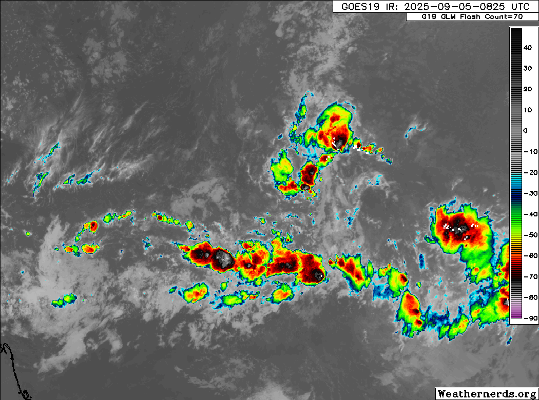
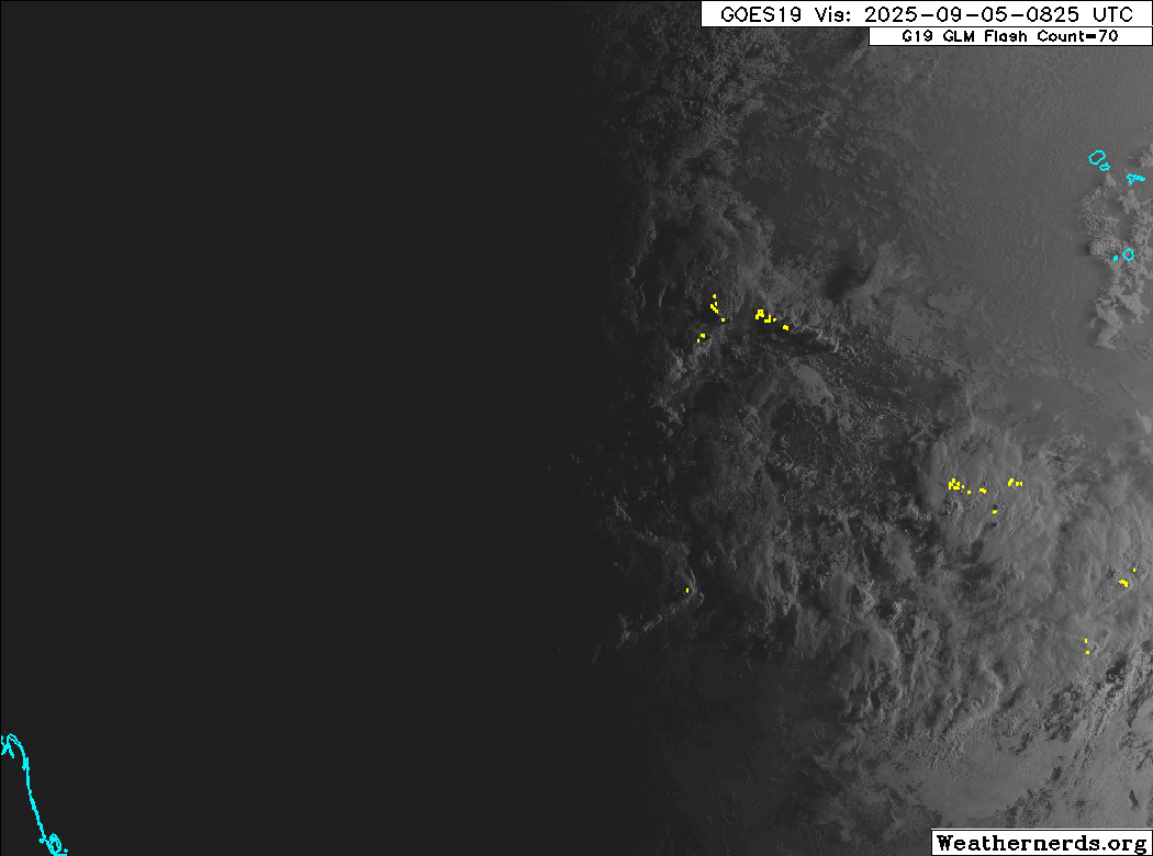
More convection around 12N, where the low level circulation is. The MLC is north of that.

0 likes
Visit the Caribbean-Central America Weather Thread where you can find at first post web cams,radars
and observations from Caribbean basin members Click Here
and observations from Caribbean basin members Click Here
Re: ATL: INVEST 91L - Models
cycloneye wrote:GCANE wrote:I have a feeling this is running thru the Carib, going thru the Yucatan Channel, and straight into the GOM. I think this will be the storm of the year.
Why it would be the storm of the year?
If it runs thru the Carib (over the highest OHC water in the Atlantic) and gets on the SW side of the TUTT which supports outflow, then this would be a very strong storm. Cat 5 would not be out of the question. I have seen it time and again where such a scenario leads to a track over the Yucatan channel straight into the GOM. CAPE is insane in the GOM. Need I say more?
2 likes
-
cycloneye
- Admin
- Posts: 146550
- Age: 69
- Joined: Thu Oct 10, 2002 10:54 am
- Location: San Juan, Puerto Rico
Re: ATL: INVEST 91L - Discussion (60/90)
Tropical Weather Outlook
NWS National Hurricane Center Miami FL
800 AM EDT Fri Sep 5 2025
For the North Atlantic...Caribbean Sea and the Gulf of America:
Tropical Atlantic (AL91):
A broad area of low pressure over the eastern tropical Atlantic,
associated with a tropical wave, is producing a disorganized area of
showers and thunderstorms. Environmental conditions are favorable
for development of this system, and a tropical depression is likely
to form over the weekend or early next week as it moves slowly
westward at 5 to 10 mph across the central tropical Atlantic. This
system is likely to be near the Lesser Antilles by the middle to
latter part of next week, and interests there should monitor its
progress.
* Formation chance through 48 hours...medium...60 percent.
* Formation chance through 7 days...high...90 percent.
$$
Forecaster Hagen
0 likes
Visit the Caribbean-Central America Weather Thread where you can find at first post web cams,radars
and observations from Caribbean basin members Click Here
and observations from Caribbean basin members Click Here

Re: ATL: INVEST 91L - Discussion (60/90)
I'm really having a hard time figuring out how this consolidates any time soon -- too elongated and that SW area has to get lost before allowing it to really gel at all the levels--, NHC changed their wording from this weekend to "this weekend or early next week." I bet that gets extended further as we go. One level of the atmosphere may look decent, but the another won't, it's been sort of a theme this season with invest areas. (99L recently and 93L from mid July for example) I'm kinda leaning toward the it goes poof idea right now because of that, watching to see if the conditions later change it or not. It'll be a while before recon could even reach it.
2 likes
-
WeatherBoy2000
- Category 1

- Posts: 417
- Joined: Mon Apr 10, 2023 9:29 am
Re: ATL: INVEST 91L - Discussion (60/90)
BobHarlem wrote:I'm really having a hard time figuring out how this consolidates any time soon -- too elongated and that SW area has to get lost before allowing it to really gel at all the levels--, NHC changed their wording from this weekend to "this weekend or early next week." I bet that gets extended further as we go. One level of the atmosphere may look decent, but the another won't, it's been sort of a theme this season with invest areas. (99L recently and 93L from mid July for example) I'm kinda leaning toward the it goes poof idea right now because of that, watching to see if the conditions later change it or not. It'll be a while before recon could even reach it.
https://i.postimg.cc/MTkYpyBx/74385151.gif
https://i.postimg.cc/m2RBFJ41/74385151-1.gif
Tbh 99l/93l were never really supported that much by the models. 93l only had the icon really, and 99l had weak support pretty much throughout its entire lifespan. This would be a much bigger bust given that models across the board had been hyping this up for several days.
0 likes
Re: ATL: INVEST 91L - Discussion (60/90)
Well, at least now we're beginning to see some actual signs of development close to the further south LLC point of 91L which has been consistently tracked by NHC. The problem however is the "double-yoked" asymmetry which I don't see changing in the short term. If nothing else though, it surely does mean that those in the Lesser Antilles will certainly need keep their heads on a swivel until the wave-T.D-T.S.-Major Hurricane moves through or passes to their north. Nothing like a plate of indecision with your morning coffee eh 

0 likes
Andy D
(For official information, please refer to the NHC and NWS products.)
(For official information, please refer to the NHC and NWS products.)
Re: ATL: INVEST 91L - Discussion (60/90)
Very classic protected pouch which in fact doesn't need a lot of protection.
LLC is in a low shear environment while convection to the north is firing from a shear gradient.
Very little SAL around this.
I am waiting to see how this looks when the LLC gets to 50W.
That is usually when waves start entraining high-TPW air from the Amazon.
It should stay weak and move due west until then.
2 likes
-
cycloneye
- Admin
- Posts: 146550
- Age: 69
- Joined: Thu Oct 10, 2002 10:54 am
- Location: San Juan, Puerto Rico
Re: ATL: INVEST 91L - Discussion (60/90)
AL, 91, 2025090512, , BEST, 0, 118N, 357W, 20, 1011, DB

0 likes
Visit the Caribbean-Central America Weather Thread where you can find at first post web cams,radars
and observations from Caribbean basin members Click Here
and observations from Caribbean basin members Click Here
Re: ATL: INVEST 91L - Discussion (60/90)
Thing to watch is this Upper-Level Low (TUTT) currently very weak at 25N 40W.
It will move west in conjucntion with 91L,
When 91L gets to the islands, the TUTT will be much stronger according to GFS.
This will keep 91L weak when it enters the west Carib.
We will see what happens then in the west Carib.
May be a different ball game then.
It will move west in conjucntion with 91L,
When 91L gets to the islands, the TUTT will be much stronger according to GFS.
This will keep 91L weak when it enters the west Carib.
We will see what happens then in the west Carib.
May be a different ball game then.
0 likes
-
MarioProtVI
- Category 4

- Posts: 959
- Age: 24
- Joined: Sun Sep 29, 2019 7:33 pm
- Location: New Jersey
Re: ATL: INVEST 91L - Discussion (60/90)
Models have drastically dropped off with 91L this morning. Don’t think this will form at all now which is going to seriously hurt the season and raises a lot of questions of what is causing the Atlantic to remain this anemic even into peak season.
0 likes

Re: ATL: INVEST 91L - Discussion (60/90)
MarioProtVI wrote:Models have drastically dropped off with 91L this morning. Don’t think this will form at all now which is going to seriously hurt the season and raises a lot of questions of what is causing the Atlantic to remain this anemic even into peak season.
Even setting aside the question of whether 91L will form (which nobody knows for sure)...
The last time someone asked identical questions was in 2024 at a similar time of the year, when pre-Francine failed to form east of the Lesser Antilles as modeled (but eventually formed in the Gulf).
Helene and Milton came after that, as well as two other MHs.
2 likes
Return to “Active Storms/Invests - Atlantic/EastPAC/CentralPAC/MED”
Who is online
Users browsing this forum: No registered users and 68 guests