NATL: MELISSA - Models

Current storms and invests:

Moderators: hurricanetrack, S2k Moderators


The posts in this forum are NOT official forecasts and should not be used as such. They are just the opinion of the poster and may or may not be backed by sound meteorological data. They are NOT endorsed by any professional institution or STORM2K. For official information, please refer to products from the National Hurricane Center and National Weather Service.

Help Support Storm2K
Message
Author
User avatar
sasha_B
Tropical Storm
Tropical Storm
Posts: 203
Age: 24
Joined: Sun Jun 30, 2024 4:32 pm
Location: Charleston, SC

Re: NATL: INVEST 98L - Models

#41 Postby sasha_B » Sun Oct 19, 2025 10:12 am

zzzh wrote:https://i.imgur.com/NajP9Cy.png
One FVN3 member has 182kt/878mb :lol:


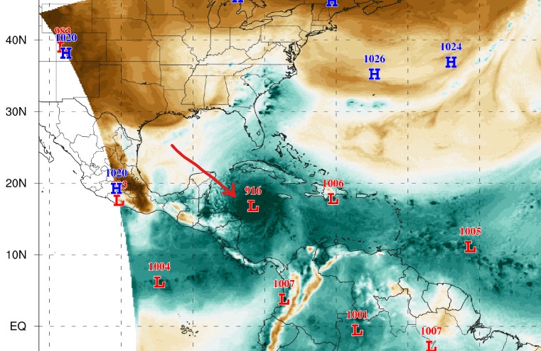
Always neat to see 'crazy model runs' like this, even if it's only a single ensemble member this time (...worth noting the number of non-record-breaking Cat 5 members on that run, though). Infinitessimally unlikely for such a thing to happen, but probably not thermodynamically impossible: 878 / 182 exceeds Wilma and Allen's records for the Atlantic (the latter by a wide margin) but would fall within the observed bounds of October western-hemisphere TC intensity.

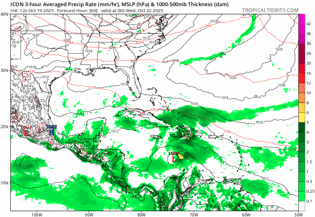
On the other hand, most of the guidance for now shows 98L becoming a TC of low-to-moderate intensity (if it develops at all, which isn't a given). I think the more realistic concern should it approach land would be rainfall & slow forward motion, like we saw with Sara last year. ERI requires everything to go right/wrong.
2 likes   

User avatar
SouthFLTropics
Category 5
Category 5
Posts: 4252
Age: 50
Joined: Thu Aug 14, 2003 8:04 am
Location: Port St. Lucie, Florida

Re: NATL: INVEST 98L - Models

#42 Postby SouthFLTropics » Sun Oct 19, 2025 10:55 am

12z ICON with a 954mb hurricane SW of Jamaica and moving slowly west at hour 180.
0 likes   
Fourth Generation Florida Native

Personal Storm History: David 79, Andrew 92, Erin 95, Floyd 99, Irene 99, Frances 04, Jeanne 04, Wilma 05, Matthew 16, Irma 17, Ian 22, Nicole 22, Milton 24

User avatar
kevin
Category 5
Category 5
Posts: 2770
Age: 27
Joined: Wed Aug 28, 2019 4:35 am

Re: NATL: INVEST 98L - Models

#43 Postby kevin » Sun Oct 19, 2025 10:57 am

We're still in the very early stage of this invest, but if the c5 runs of 98L become reality this would be the only season besides 2005 on record to feature 3 or more cat 5 hurricanes (2005 had 4).

Even if it'd 'just' become a MH, the season would be at 13/5/4 which is still quite a unique season total. Many of the similar seasons like 1894 (7/5/4) 1909 (12/6/4) & 1964 (13/7/5) are from before the satellite era when these high MH/TS and MH/H ratios were more common due to missed storms. The only kinda similar 'recent' season is 1988 with 12/5/3.
4 likes   

User avatar
SFLcane
S2K Supporter
S2K Supporter
Posts: 10275
Age: 47
Joined: Sat Jun 05, 2010 1:44 pm
Location: Lake Worth Florida

Re: NATL: INVEST 98L - Models

#44 Postby SFLcane » Sun Oct 19, 2025 11:08 am

SouthFLTropics wrote:12z ICON with a 954mb hurricane SW of Jamaica and moving slowly west at hour 180.


Indeed!

Image
4 likes   

User avatar
SFLcane
S2K Supporter
S2K Supporter
Posts: 10275
Age: 47
Joined: Sat Jun 05, 2010 1:44 pm
Location: Lake Worth Florida

Re: NATL: INVEST 98L - Models

#45 Postby SFLcane » Sun Oct 19, 2025 11:11 am

SouthFLTropics wrote:12z ICON with a 954mb hurricane SW of Jamaica and moving slowly west at hour 180.


Andys model again 06z run has another C5 heading into the NW carib. :eek:

https://storm.aoml.noaa.gov/basin/anima ... casthr=000

Image
4 likes   

User avatar
Blown Away
S2K Supporter
S2K Supporter
Posts: 10216
Joined: Wed May 26, 2004 6:17 am

Re: NATL: INVEST 98L - Models

#46 Postby Blown Away » Sun Oct 19, 2025 11:47 am

Image

Yikes for DR/PR if the GFS is right! :double:
2 likes   
Hurricane Eye Experience: David 79, Irene 99, Frances 04, Jeanne 04, Wilma 05… Hurricane Brush Experience: Andrew 92, Erin 95, Floyd 99, Matthew 16, Irma 17, Ian 22, Nicole 22…

User avatar
NDG
S2K Supporter
S2K Supporter
Posts: 15493
Joined: Sun Jul 09, 2006 10:14 pm
Location: Orlando, FL

Re: NATL: INVEST 98L - Models

#47 Postby NDG » Sun Oct 19, 2025 11:51 am

Don't put too much stock on the GFS.

 https://x.com/NDGMETCHEF/status/1979948650596880611

7 likes   

Pelicane
Tropical Storm
Tropical Storm
Posts: 179
Joined: Tue Sep 13, 2022 1:52 pm
Location: Lafayette, Louisiana

Re: NATL: INVEST 98L - Models

#48 Postby Pelicane » Sun Oct 19, 2025 12:21 pm

NDG wrote:Don't put too much stock on the GFS.

 https://x.com/NDGMETCHEF/status/1979948650596880611


GEFS trended notably westward FWIW
1 likes   

IsabelaWeather
Category 1
Category 1
Posts: 309
Age: 36
Joined: Tue Jul 07, 2020 7:29 am
Location: Isabela, Puerto Rico

Re: NATL: INVEST 98L - Models

#49 Postby IsabelaWeather » Sun Oct 19, 2025 12:31 pm

Pelicane wrote:
NDG wrote:Don't put too much stock on the GFS.

 https://x.com/NDGMETCHEF/status/1979948650596880611


GEFS trended notably westward FWIW


I'm not sure, looks like more members are east at 12z than 6z
0 likes   

User avatar
Ubuntwo
Category 5
Category 5
Posts: 1441
Age: 31
Joined: Thu Oct 05, 2017 10:41 pm

Re: NATL: INVEST 98L - Models

#50 Postby Ubuntwo » Sun Oct 19, 2025 12:35 pm

IsabelaWeather wrote:
Pelicane wrote:
NDG wrote:Don't put too much stock on the GFS.

 https://x.com/NDGMETCHEF/status/1979948650596880611


GEFS trended notably westward FWIW


I'm not sure, looks like more members are east at 12z than 6z

Fewer members doing a quick curve through Hispaniola (the western group is larger), but that west group is not as far west. Fewer members drifting around. Looks like the mean clusters through eastern Cuba.
2 likes   
Kendall -> SLO -> PBC

Memorable Storms: Katrina (for its Florida landfall...) Wilma Matthew Irma

MEANINGLESS_NUMBERS
Category 1
Category 1
Posts: 445
Joined: Mon Nov 02, 2020 1:43 pm

Re: NATL: INVEST 98L - Models

#51 Postby MEANINGLESS_NUMBERS » Sun Oct 19, 2025 12:51 pm

No development on the Euro. Minimal TS on the Canadian. Yes, some models show Cat 5 but even a hurricane is not a sure-thing.
1 likes   
Emily '87, Felix '95, Gert '99, Fabian '03, Humberto '19, Paulette '20, Teddy '20, Fiona '22, Lee '23, Ernesto '24, Humberto/Imelda '25

User avatar
Ubuntwo
Category 5
Category 5
Posts: 1441
Age: 31
Joined: Thu Oct 05, 2017 10:41 pm

Re: NATL: INVEST 98L - Models

#52 Postby Ubuntwo » Sun Oct 19, 2025 1:07 pm

MEANINGLESS_NUMBERS wrote:No development on the Euro. Minimal TS on the Canadian. Yes, some models show Cat 5 but even a hurricane is not a sure-thing.

12z Euro has a 983mb hurricane into eastern Cuba, passing through the Bahamas and peaking in the 960s.
2 likes   
Kendall -> SLO -> PBC

Memorable Storms: Katrina (for its Florida landfall...) Wilma Matthew Irma

User avatar
cycloneye
Admin
Admin
Posts: 147899
Age: 69
Joined: Thu Oct 10, 2002 10:54 am
Location: San Juan, Puerto Rico

Re: NATL: INVEST 98L - Models

#53 Postby cycloneye » Sun Oct 19, 2025 1:09 pm

12z EURO develops and tracks NE thru Cuba.

Image
2 likes   
Visit the Caribbean-Central America Weather Thread where you can find at first post web cams,radars
and observations from Caribbean basin members Click Here

IsabelaWeather
Category 1
Category 1
Posts: 309
Age: 36
Joined: Tue Jul 07, 2020 7:29 am
Location: Isabela, Puerto Rico

Re: NATL: INVEST 98L - Models

#54 Postby IsabelaWeather » Sun Oct 19, 2025 1:16 pm

cycloneye wrote:12z EURO develops and tracks NE thru Cuba.

https://i.imgur.com/VYAu2R8.gif


Caving to the GFS?
0 likes   

User avatar
Ubuntwo
Category 5
Category 5
Posts: 1441
Age: 31
Joined: Thu Oct 05, 2017 10:41 pm

Re: NATL: INVEST 98L - Models

#55 Postby Ubuntwo » Sun Oct 19, 2025 1:49 pm

IsabelaWeather wrote:
cycloneye wrote:12z EURO develops and tracks NE thru Cuba.

https://i.imgur.com/VYAu2R8.gif


Caving to the GFS?

GFS develops very quickly (in about three days) and turns almost immediately into Hispaniola. The Euro takes far longer to develop - about a whole week. This timing difference hasn't tightened up much unfortunately. The Euro is most similar to the western camp of the GEFS in that slower development and track a bit further west.
2 likes   
Kendall -> SLO -> PBC

Memorable Storms: Katrina (for its Florida landfall...) Wilma Matthew Irma

User avatar
Ubuntwo
Category 5
Category 5
Posts: 1441
Age: 31
Joined: Thu Oct 05, 2017 10:41 pm

Re: NATL: INVEST 98L - Models

#56 Postby Ubuntwo » Sun Oct 19, 2025 1:50 pm

12z FNV3 is back to favoring the GFS solution:
Image
0 likes   
Kendall -> SLO -> PBC

Memorable Storms: Katrina (for its Florida landfall...) Wilma Matthew Irma

User avatar
Blown Away
S2K Supporter
S2K Supporter
Posts: 10216
Joined: Wed May 26, 2004 6:17 am

Re: NATL: INVEST 98L - Models

#57 Postby Blown Away » Sun Oct 19, 2025 2:15 pm

IsabelaWeather wrote:
cycloneye wrote:12z EURO develops and tracks NE thru Cuba.

https://i.imgur.com/VYAu2R8.gif


Caving to the GFS?


I don’t think so, just closing in on time and accuracy. GFS has slowly moved W away from PR towards EURO.
0 likes   
Hurricane Eye Experience: David 79, Irene 99, Frances 04, Jeanne 04, Wilma 05… Hurricane Brush Experience: Andrew 92, Erin 95, Floyd 99, Matthew 16, Irma 17, Ian 22, Nicole 22…

User avatar
cycloneye
Admin
Admin
Posts: 147899
Age: 69
Joined: Thu Oct 10, 2002 10:54 am
Location: San Juan, Puerto Rico

Re: NATL: INVEST 98L - Models

#58 Postby cycloneye » Sun Oct 19, 2025 2:23 pm

Image

Image
1 likes   
Visit the Caribbean-Central America Weather Thread where you can find at first post web cams,radars
and observations from Caribbean basin members Click Here

User avatar
Blown Away
S2K Supporter
S2K Supporter
Posts: 10216
Joined: Wed May 26, 2004 6:17 am

Re: NATL: INVEST 98L - Models

#59 Postby Blown Away » Sun Oct 19, 2025 2:26 pm

Image

12z GEFS… Wide W swing now with stronger members…
8 likes   
Hurricane Eye Experience: David 79, Irene 99, Frances 04, Jeanne 04, Wilma 05… Hurricane Brush Experience: Andrew 92, Erin 95, Floyd 99, Matthew 16, Irma 17, Ian 22, Nicole 22…

IsabelaWeather
Category 1
Category 1
Posts: 309
Age: 36
Joined: Tue Jul 07, 2020 7:29 am
Location: Isabela, Puerto Rico

Re: NATL: INVEST 98L - Models

#60 Postby IsabelaWeather » Sun Oct 19, 2025 3:55 pm

Blown Away wrote:
IsabelaWeather wrote:
cycloneye wrote:12z EURO develops and tracks NE thru Cuba.

https://i.imgur.com/VYAu2R8.gif


Caving to the GFS?


I don’t think so, just closing in on time and accuracy. GFS has slowly moved W away from PR towards EURO.


I wouldnt say that, I didnt mean a track to PR, the gfs hasnt shown that in like 4 or 5 runs, i mean a track into Hispaniola and the NE movement. Focusing on the NE movement as opposed to N over W cuba
1 likes   


Return to “Active Storms/Invests - Atlantic/EastPAC/CentralPAC/MED”

Who is online

Users browsing this forum: Category5Kaiju, Deshaunrob17, pepecool20 and 85 guests