ATL: ERIN - Models

Moderator: S2k Moderators

Message
Author
User avatar
Hurricaneman
Category 5
Category 5
Posts: 7396
Age: 45
Joined: Tue Aug 31, 2004 3:24 pm
Location: central florida

Re: ATL: ERIN - Models

#401 Postby Hurricaneman » Wed Aug 13, 2025 11:23 pm

convergencezone2 wrote:interesting trends with some of the models today / tonight. It will also interesteing to see how much this affects wave action along the east coast if it gets a bit closer.

With the model trends I can’t even dismiss a North Carolina Landfall
5 likes   

Keldeo1997
Category 2
Category 2
Posts: 655
Joined: Fri Oct 11, 2019 11:35 pm

Re: ATL: ERIN - Models

#402 Postby Keldeo1997 » Wed Aug 13, 2025 11:26 pm

1 likes   

zzzh
Category 3
Category 3
Posts: 886
Joined: Thu Sep 02, 2021 1:13 pm

Re: ATL: ERIN - Models

#403 Postby zzzh » Wed Aug 13, 2025 11:30 pm

4 likes   

User avatar
Hurricaneman
Category 5
Category 5
Posts: 7396
Age: 45
Joined: Tue Aug 31, 2004 3:24 pm
Location: central florida

Re: ATL: ERIN - Models

#404 Postby Hurricaneman » Wed Aug 13, 2025 11:38 pm

Also if that ridge builds back in faster than modeled areas south and west of North Carolina may have to keep tabs on this as this is so close to getting trapped by the rebuilding ridge, the only real hope is if the trough is a little slower in leaving
3 likes   

User avatar
Hurricaneman
Category 5
Category 5
Posts: 7396
Age: 45
Joined: Tue Aug 31, 2004 3:24 pm
Location: central florida

Re: ATL: ERIN - Models

#405 Postby Hurricaneman » Wed Aug 13, 2025 11:40 pm

The 0zGFS is showing a recurve about .8 degree west of 18z so the trend is not our friend
3 likes   

User avatar
Hybridstorm_November2001
S2K Supporter
S2K Supporter
Posts: 2813
Joined: Sat Aug 21, 2004 2:50 pm
Location: SW New Brunswick, Canada
Contact:

Re: ATL: ERIN - Models

#406 Postby Hybridstorm_November2001 » Wed Aug 13, 2025 11:45 pm

Hurricaneman wrote:Also if that ridge builds back in faster than modeled areas south and west of North Carolina may have to keep tabs on this as this is so close to getting trapped by the rebuilding ridge, the only real hope is if the trough is a little slower in leaving


I would not be surprised if this were to happen. The current cold front that is coming through the Northeast was supposed to arrive early today, until 48 hours ago now it will push through early on Thursday, fully off the coast instead. If something similar happens with the ridge in the longer range, a mistiming in the wrong direction, it would potentially be catastrophic. So, timing is everything here.
1 likes   

LarryWx
S2K Supporter
S2K Supporter
Posts: 6509
Joined: Sun Sep 07, 2003 2:04 pm
Location: GA

Re: ATL: ERIN - Models

#407 Postby LarryWx » Thu Aug 14, 2025 12:47 am

0Z Euro: 200 miles E of 12Z/recurves near 72.5W vs 75W of 12Z and yesterday’s 0Z recurving near 70W.
2 likes   
Personal Forecast Disclaimer:
The posts in this forum are NOT official forecasts and should not be used as such. They are just the opinion of the poster and may or may not be backed by sound meteorological data. They are NOT endorsed by any professional institution or storm2k.org. For official information, please refer to the NHC and NWS products.

jlauderdal
S2K Supporter
S2K Supporter
Posts: 7210
Joined: Wed May 19, 2004 5:46 am
Location: NE Fort Lauderdale
Contact:

Re: ATL: ERIN - Models

#408 Postby jlauderdal » Thu Aug 14, 2025 4:51 am

Hurricaneman wrote:The 0zGFS is showing a recurve about .8 degree west of 18z so the trend is not our friend

You can relax, the break in the ridge isn't going anywhere.
1 likes   

Cachondo23
Tropical Storm
Tropical Storm
Posts: 104
Joined: Wed May 25, 2022 5:56 am

Re: ATL: ERIN - Models

#409 Postby Cachondo23 » Thu Aug 14, 2025 5:13 am

06z GFS a bit closer to NE Leeward Islands while ICON now further east, confusing situation.
0 likes   

BobHarlem
Category 5
Category 5
Posts: 2362
Joined: Thu Oct 20, 2005 6:11 pm

Re: ATL: ERIN - Models

#410 Postby BobHarlem » Thu Aug 14, 2025 5:58 am

Interesting left shift on the 6z GFS ensembles this morning (One interesting change is that there is nothing over or east of Bermuda out to 162 hours), recon is sorely needed.

Last 3 runs trend
Image
3 likes   

User avatar
GCANE
S2K Supporter
S2K Supporter
Posts: 11640
Joined: Mon Oct 22, 2007 8:03 am

ATL: ERIN - Tropical Storm - Discussion

#411 Postby GCANE » Thu Aug 14, 2025 6:08 am

Run to run ICON has slowed this down a bit but intensified it by 17mb
1 likes   

User avatar
GCANE
S2K Supporter
S2K Supporter
Posts: 11640
Joined: Mon Oct 22, 2007 8:03 am

Re: ATL: ERIN - Models

#412 Postby GCANE » Thu Aug 14, 2025 6:23 am

EAGLE has the farthest west distribution

Image
1 likes   

User avatar
kevin
Category 5
Category 5
Posts: 2658
Age: 26
Joined: Wed Aug 28, 2019 4:35 am

Re: ATL: ERIN - Models

#413 Postby kevin » Thu Aug 14, 2025 7:06 am

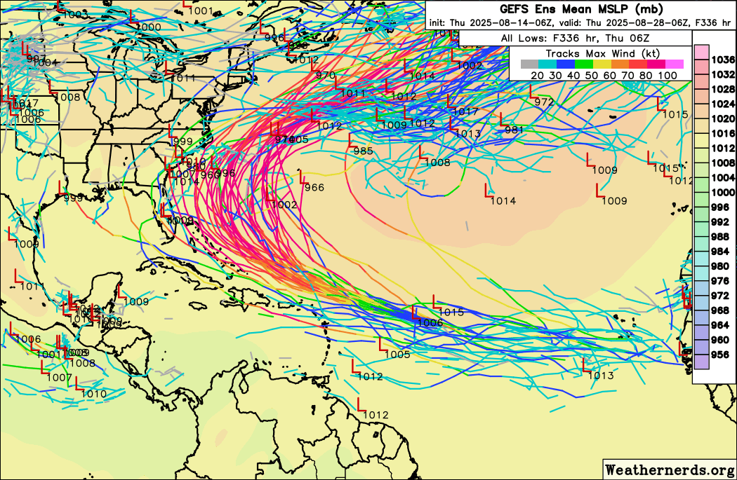
06z GEFS shifts west and it looks like at least three members will make landfall in the US. All members are now west of Bermuda.

Image
0 likes   

OuterBanker
S2K Supporter
S2K Supporter
Posts: 1750
Joined: Wed Feb 26, 2003 10:53 am
Location: Nags Head, NC
Contact:

Re: ATL: ERIN - Models

#414 Postby OuterBanker » Thu Aug 14, 2025 7:08 am

[quote="BobHarlem"]Interesting left shift on the 6z GFS ensembles this morning (One interesting change is that there is nothing over or east of Bermuda out to 162 hours), recon is sorely needed.

Last 3 runs trend
https://i.imgur.com/hadCU8F.gif[/quotI understand that the G4 is scheduled from Barbados today.
0 likes   

User avatar
cycloneye
Admin
Admin
Posts: 146358
Age: 69
Joined: Thu Oct 10, 2002 10:54 am
Location: San Juan, Puerto Rico

Re: ATL: ERIN - Models

#415 Postby cycloneye » Thu Aug 14, 2025 7:14 am

0 likes   
Visit the Caribbean-Central America Weather Thread where you can find at first post web cams,radars
and observations from Caribbean basin members Click Here

User avatar
cycloneye
Admin
Admin
Posts: 146358
Age: 69
Joined: Thu Oct 10, 2002 10:54 am
Location: San Juan, Puerto Rico

Re: ATL: ERIN - Models

#416 Postby cycloneye » Thu Aug 14, 2025 7:54 am

12z SHIP run. Still moving west at 270 degress.

Image
1 likes   
Visit the Caribbean-Central America Weather Thread where you can find at first post web cams,radars
and observations from Caribbean basin members Click Here

User avatar
Teban54
Category 5
Category 5
Posts: 3269
Joined: Sat May 19, 2018 1:19 pm

Re: ATL: ERIN - Models

#417 Postby Teban54 » Thu Aug 14, 2025 8:43 am

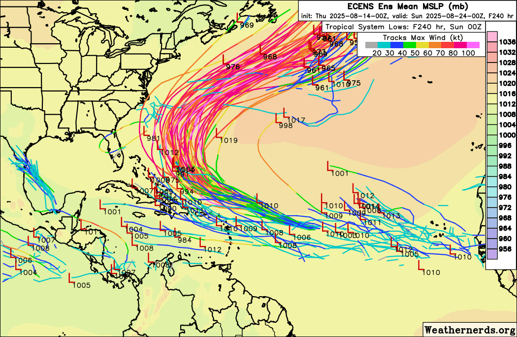
Interestingly, 6z GEFS is now further west than 0z Euro ensembles, even though their operational runs had been the other way round.

Image
Image
3 likes   

User avatar
mitchell
Category 1
Category 1
Posts: 419
Joined: Wed Mar 19, 2003 8:22 am
Location: Delaware
Contact:

Re: ATL: ERIN - Models

#418 Postby mitchell » Thu Aug 14, 2025 9:23 am

Hurricaneman wrote:
convergencezone2 wrote:interesting trends with some of the models today / tonight. It will also interesteing to see how much this affects wave action along the east coast if it gets a bit closer.

With the model trends I can’t even dismiss a North Carolina Landfall


Wave heights and periods based on the 06z GFS model showing 12 foot waves at 16 second periods (significant wave height) Outerbanks. That would easily translate into 10-15 foot breaking waves. Obviously some of the tracks and models yesterday evening were showing bigger wave heights than this.

Image
0 likes   

User avatar
Kingarabian
S2K Supporter
S2K Supporter
Posts: 16108
Joined: Sat Aug 08, 2009 3:06 am
Location: Honolulu, Hawaii

Re: ATL: ERIN - Models

#419 Postby Kingarabian » Thu Aug 14, 2025 10:08 am

12z ICON rolling.
0 likes   
RIP Kobe Bryant

User avatar
Kingarabian
S2K Supporter
S2K Supporter
Posts: 16108
Joined: Sat Aug 08, 2009 3:06 am
Location: Honolulu, Hawaii

Re: ATL: ERIN - Models

#420 Postby Kingarabian » Thu Aug 14, 2025 10:14 am

12z ICON similar to the most recent 00z run. Further south through hour 48.
0 likes   
RIP Kobe Bryant


Return to “2025”

Who is online

Users browsing this forum: No registered users and 34 guests