ATL: ERIN - Models
Moderator: S2k Moderators
-
DunedinDave
- Category 1

- Posts: 254
- Joined: Fri Aug 25, 2023 10:31 am
Re: ATL: ERIN - Models
You can see on ICON 12z through that high eroding and the pathway opening up for a north turn. Question is going to be how sharp will turn be come next week? A gradual NW turn is seeming more plausible compared to a sharp N to NE turn like originally thought.
Getting Hugo vibes here. Or Floyd vibes.
Getting Hugo vibes here. Or Floyd vibes.
0 likes
-
TampaWxLurker
- Tropical Storm

- Posts: 157
- Joined: Thu Aug 01, 2024 8:20 am
Re: ATL: ERIN - Models
The trend is definitely no bueno, especially for the BVI, Turks and Caicos and Bahamas.
Its still possible, but in my opinion a "clean" out to sea route is started to close up. Someone's going to get SOMETHING out of Erin, unfortunately, I think.
Its still possible, but in my opinion a "clean" out to sea route is started to close up. Someone's going to get SOMETHING out of Erin, unfortunately, I think.
0 likes
- Fishing
- S2K Supporter

- Posts: 69
- Age: 66
- Joined: Thu Sep 03, 2015 11:53 am
- Location: Mount Pleasant, SC
Re: ATL: ERIN - Models
DunedinDave wrote:You can see on ICON 12z through that high eroding and the pathway opening up for a north turn. Question is going to be how sharp will turn be come next week? A gradual NW turn is seeming more plausible compared to a sharp N to NE turn like originally thought.
Getting Hugo vibes here. Or Floyd vibes.
Bite your tongue!! I'm feeling some Hugo vibes as well, but if I were to put money on it (Somewhere NC) .
Sent from my iPhone using Tapatalk
0 likes
-
AutoPenalti
- Category 5

- Posts: 4060
- Age: 29
- Joined: Mon Aug 17, 2015 4:16 pm
- Location: Ft. Lauderdale, Florida
Re: ATL: ERIN - Models
It's definitely a shift left from the 06z but right of the 0z. Basically in the middle of both runs.
0 likes
The posts in this forum are NOT official forecasts and should not be used as such. They are just the opinion of the poster and may or may not be backed by sound meteorological data. They are NOT endorsed by any professional institution or STORM2K. For official information, please refer to products from the NHC and NWS.
Model Runs Cheat Sheet:
GFS (5:30 AM/PM, 11:30 AM/PM)
HWRF, GFDL, UKMET, NAVGEM (6:30-8:00 AM/PM, 12:30-2:00 AM/PM)
ECMWF (1:45 AM/PM)
TCVN is a weighted averaged
-
DunedinDave
- Category 1

- Posts: 254
- Joined: Fri Aug 25, 2023 10:31 am
Re: ATL: ERIN - Models
Well 5 days ago I said if I had $100, I’d put $70 on out to sea, $20 on scraping NC/NE and 10 on Fla.
Now I’d say 50 out to sea. 35 on a NC or SC scraping. 10 on a Matthew-like Florida scraping. And 5 getting into the Gulf.
That said, I am horrible at betting.
Now I’d say 50 out to sea. 35 on a NC or SC scraping. 10 on a Matthew-like Florida scraping. And 5 getting into the Gulf.
That said, I am horrible at betting.
3 likes
- Kingarabian
- S2K Supporter

- Posts: 16108
- Joined: Sat Aug 08, 2009 3:06 am
- Location: Honolulu, Hawaii
Re: ATL: ERIN - Models
12z Icon closest approach to Outer Banks. Earlier on it's left of the 06z, but here it's roughly the same place as the 0z.


0 likes
- Kingarabian
- S2K Supporter

- Posts: 16108
- Joined: Sat Aug 08, 2009 3:06 am
- Location: Honolulu, Hawaii
- Kingarabian
- S2K Supporter

- Posts: 16108
- Joined: Sat Aug 08, 2009 3:06 am
- Location: Honolulu, Hawaii
-
AutoPenalti
- Category 5

- Posts: 4060
- Age: 29
- Joined: Mon Aug 17, 2015 4:16 pm
- Location: Ft. Lauderdale, Florida
Re: ATL: ERIN - Models
I would wager it's more a of speed up than a shift left. The synoptic set up seems about the same so far.
0 likes
The posts in this forum are NOT official forecasts and should not be used as such. They are just the opinion of the poster and may or may not be backed by sound meteorological data. They are NOT endorsed by any professional institution or STORM2K. For official information, please refer to products from the NHC and NWS.
Model Runs Cheat Sheet:
GFS (5:30 AM/PM, 11:30 AM/PM)
HWRF, GFDL, UKMET, NAVGEM (6:30-8:00 AM/PM, 12:30-2:00 AM/PM)
ECMWF (1:45 AM/PM)
TCVN is a weighted averaged
-
AutoPenalti
- Category 5

- Posts: 4060
- Age: 29
- Joined: Mon Aug 17, 2015 4:16 pm
- Location: Ft. Lauderdale, Florida
Re: ATL: ERIN - Models
If the GFS solution verifies, Erin should be crossing over 18N by tomorrow night.
Last edited by AutoPenalti on Thu Aug 14, 2025 11:03 am, edited 1 time in total.
1 likes
The posts in this forum are NOT official forecasts and should not be used as such. They are just the opinion of the poster and may or may not be backed by sound meteorological data. They are NOT endorsed by any professional institution or STORM2K. For official information, please refer to products from the NHC and NWS.
Model Runs Cheat Sheet:
GFS (5:30 AM/PM, 11:30 AM/PM)
HWRF, GFDL, UKMET, NAVGEM (6:30-8:00 AM/PM, 12:30-2:00 AM/PM)
ECMWF (1:45 AM/PM)
TCVN is a weighted averaged
- Kingarabian
- S2K Supporter

- Posts: 16108
- Joined: Sat Aug 08, 2009 3:06 am
- Location: Honolulu, Hawaii
Re: ATL: ERIN - Models
AutoPenalti wrote:I would wager it's more a of speed up than a shift left. The synoptic set up seems about the same so far.
A faster forward speed could mean a stronger ridge though
0 likes
RIP Kobe Bryant
- Kingarabian
- S2K Supporter

- Posts: 16108
- Joined: Sat Aug 08, 2009 3:06 am
- Location: Honolulu, Hawaii
-
AutoPenalti
- Category 5

- Posts: 4060
- Age: 29
- Joined: Mon Aug 17, 2015 4:16 pm
- Location: Ft. Lauderdale, Florida
Re: ATL: ERIN - Models
Kingarabian wrote:AutoPenalti wrote:I would wager it's more a of speed up than a shift left. The synoptic set up seems about the same so far.
A faster forward speed could mean a stronger ridge though
If the trough lifts out quicker, then yeah, could be a problem.
0 likes
The posts in this forum are NOT official forecasts and should not be used as such. They are just the opinion of the poster and may or may not be backed by sound meteorological data. They are NOT endorsed by any professional institution or STORM2K. For official information, please refer to products from the NHC and NWS.
Model Runs Cheat Sheet:
GFS (5:30 AM/PM, 11:30 AM/PM)
HWRF, GFDL, UKMET, NAVGEM (6:30-8:00 AM/PM, 12:30-2:00 AM/PM)
ECMWF (1:45 AM/PM)
TCVN is a weighted averaged
Re: ATL: ERIN - Models
12Z UKMET: similar to last two with recurve at 71.9W:
TROPICAL STORM ERIN ANALYSED POSITION : 16.6N 49.1W
ATCF IDENTIFIER : AL052025
LEAD CENTRAL MAXIMUM WIND
VERIFYING TIME TIME POSITION PRESSURE (MB) SPEED (KNOTS)
-------------- ---- -------- ------------- -------------
1200UTC 14.08.2025 0 16.6N 49.1W 1005 33
0000UTC 15.08.2025 12 17.5N 51.8W 1006 33
1200UTC 15.08.2025 24 18.5N 55.5W 1004 34
0000UTC 16.08.2025 36 19.2N 58.9W 1003 35
1200UTC 16.08.2025 48 19.7N 62.3W 999 36
0000UTC 17.08.2025 60 20.1N 65.0W 996 37
1200UTC 17.08.2025 72 20.8N 67.3W 993 41
0000UTC 18.08.2025 84 22.0N 68.9W 990 44
1200UTC 18.08.2025 96 23.8N 70.3W 988 49
0000UTC 19.08.2025 108 26.0N 71.2W 985 50
1200UTC 19.08.2025 120 28.3N 71.7W 981 52
0000UTC 20.08.2025 132 30.5N 71.9W 979 52
1200UTC 20.08.2025 144 32.6N 71.0W 976 59
0000UTC 21.08.2025 156 34.6N 68.7W 970 66
1200UTC 21.08.2025 168 36.4N 65.0W 969 63
0 likes
Personal Forecast Disclaimer:
The posts in this forum are NOT official forecasts and should not be used as such. They are just the opinion of the poster and may or may not be backed by sound meteorological data. They are NOT endorsed by any professional institution or storm2k.org. For official information, please refer to the NHC and NWS products.
The posts in this forum are NOT official forecasts and should not be used as such. They are just the opinion of the poster and may or may not be backed by sound meteorological data. They are NOT endorsed by any professional institution or storm2k.org. For official information, please refer to the NHC and NWS products.
-
WeatherBoy2000
- Category 1

- Posts: 407
- Joined: Mon Apr 10, 2023 9:29 am
- Kingarabian
- S2K Supporter

- Posts: 16108
- Joined: Sat Aug 08, 2009 3:06 am
- Location: Honolulu, Hawaii
Re: ATL: ERIN - Models
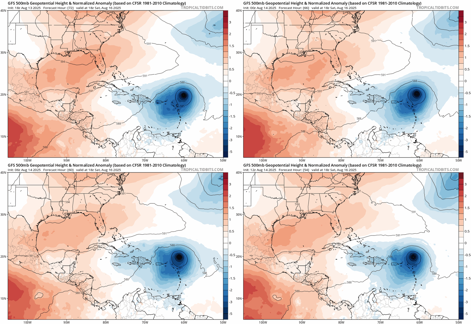
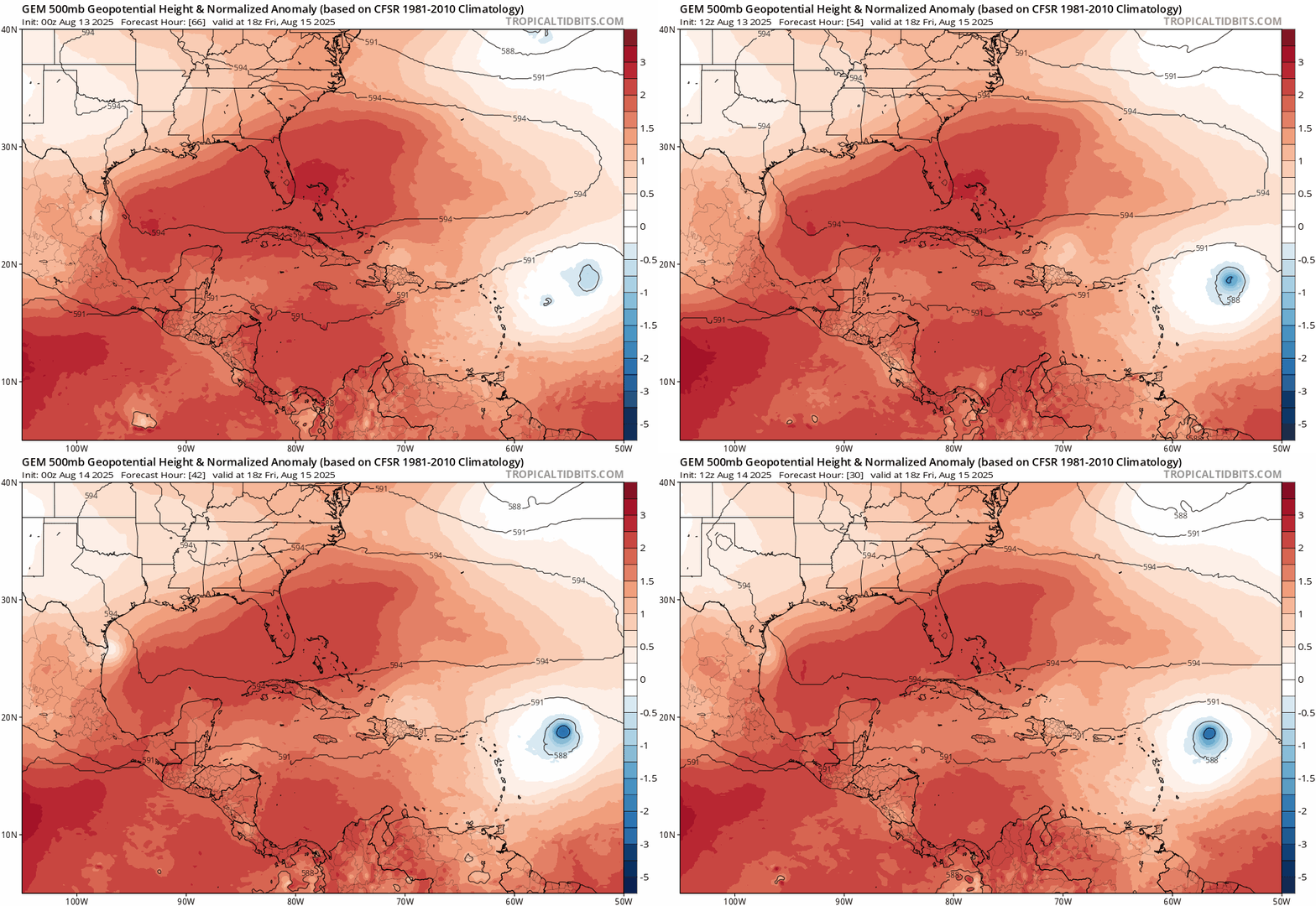
12z GFS and CMC with west shifts as well but should be clean recurves.
Ensembles could be interesting
Ensembles could be interesting
0 likes
RIP Kobe Bryant
Re: ATL: ERIN - Models
Erin's positions and intensity a week from now from the last four GFS model runs. Pretty small variation for a week+ out.


0 likes
-
HurricaneIrma
- Tropical Low

- Posts: 43
- Age: 44
- Joined: Mon Sep 03, 2018 9:37 am
- Location: Wilmington NC
-
TampaWxLurker
- Tropical Storm

- Posts: 157
- Joined: Thu Aug 01, 2024 8:20 am
Re: ATL: ERIN - Models
On the 12z GFS, eastern Newfoundland/St John's gets clipped pretty good by Erin as it transitions into being extratropical.
1 likes
Who is online
Users browsing this forum: hipshot and 28 guests


