
ATL: ERIN - Hurricane - Discussion
Moderators: hurricanetrack, S2k Moderators

The posts in this forum are NOT official forecasts and should not be used as such. They are just the opinion of the poster and may or may not be backed by sound meteorological data. They are NOT endorsed by any professional institution or STORM2K. For official information, please refer to products from the National Hurricane Center and National Weather Service.

-
Sciencerocks
- Category 5

- Posts: 9256
- Age: 39
- Joined: Thu Jul 06, 2017 1:51 am
-
CrazyC83
- Professional-Met

- Posts: 34043
- Joined: Tue Mar 07, 2006 11:57 pm
- Location: Deep South, for the first time!
Re: ATL: ERIN - Hurricane - Discussion
That most recent Recon pass supports 80 kt. I'd want to see a bit higher before going up more though, as 92 kt FL = 83 kt at the surface but the SFMR is lower (even if that should get less weight due to reliability questions).
0 likes

Re: ATL: ERIN - Hurricane - Discussion
Agree.coming together nicely. Nothing like lower sheer and warmer SSTs. For now the heading looking closer to 265 than 280. That weakness will be there just don’t want to see too much of a slowdown.
0 likes
-
Hurricane2022

- Category 5
- Posts: 1610
- Joined: Tue Aug 23, 2022 11:38 pm
- Location: Araçatuba, Brazil
Re: ATL: ERIN - Hurricane - Discussion
https://x.com/cyclonicwx/status/1956549110019854346
....I mean, if this trend continues, we may see a 130-140 kt MH in about 24 hours.
....I mean, if this trend continues, we may see a 130-140 kt MH in about 24 hours.
4 likes
Sorry for the bad English sometimes...!
For reliable and detailed information for any meteorological phenomenon, please consult the National Hurricane Center, Joint Typhoon Warning Center , or your local Meteo Center.
--------
Una cvm Christo, pro Christo, et in Christo. Sit nomen Domini benedictvm.
For reliable and detailed information for any meteorological phenomenon, please consult the National Hurricane Center, Joint Typhoon Warning Center , or your local Meteo Center.
--------
Una cvm Christo, pro Christo, et in Christo. Sit nomen Domini benedictvm.
-
Hurricane2022
- Category 5
- Posts: 1610
- Joined: Tue Aug 23, 2022 11:38 pm
- Location: Araçatuba, Brazil
Re: ATL: ERIN - Hurricane - Discussion
ESTIMATED MINIMUM CENTRAL PRESSURE 979 MB
EYE DIAMETER 15 NM
MAX SUSTAINED WINDS 85 KT WITH GUSTS TO 105 KT.
64 KT....... 25NE 15SE 10SW 20NW.
50 KT....... 40NE 30SE 15SW 40NW.
34 KT.......110NE 50SE 30SW 100NW.
4 M SEAS....210NE 120SE 75SW 180NW.
EYE DIAMETER 15 NM
MAX SUSTAINED WINDS 85 KT WITH GUSTS TO 105 KT.
64 KT....... 25NE 15SE 10SW 20NW.
50 KT....... 40NE 30SE 15SW 40NW.
34 KT.......110NE 50SE 30SW 100NW.
4 M SEAS....210NE 120SE 75SW 180NW.
0 likes
Sorry for the bad English sometimes...!
For reliable and detailed information for any meteorological phenomenon, please consult the National Hurricane Center, Joint Typhoon Warning Center , or your local Meteo Center.
--------
Una cvm Christo, pro Christo, et in Christo. Sit nomen Domini benedictvm.
For reliable and detailed information for any meteorological phenomenon, please consult the National Hurricane Center, Joint Typhoon Warning Center , or your local Meteo Center.
--------
Una cvm Christo, pro Christo, et in Christo. Sit nomen Domini benedictvm.
-
CrazyC83
- Professional-Met
- Posts: 34043
- Joined: Tue Mar 07, 2006 11:57 pm
- Location: Deep South, for the first time!
Re: ATL: ERIN - Hurricane - Discussion
It looks like it's all systems to go now.
An earlier peak looks possible now, as shear looks to increase next week. Given the eyewall dynamics, that could mean a sprawling, lumbering storm with a poor inner core. Maybe something like a category 2 with a pressure of 940 mb.
An earlier peak looks possible now, as shear looks to increase next week. Given the eyewall dynamics, that could mean a sprawling, lumbering storm with a poor inner core. Maybe something like a category 2 with a pressure of 940 mb.
5 likes
-
Hurricane2022
- Category 5
- Posts: 1610
- Joined: Tue Aug 23, 2022 11:38 pm
- Location: Araçatuba, Brazil
Re: ATL: ERIN - Hurricane - Discussion

2 likes
Sorry for the bad English sometimes...!
For reliable and detailed information for any meteorological phenomenon, please consult the National Hurricane Center, Joint Typhoon Warning Center , or your local Meteo Center.
--------
Una cvm Christo, pro Christo, et in Christo. Sit nomen Domini benedictvm.
For reliable and detailed information for any meteorological phenomenon, please consult the National Hurricane Center, Joint Typhoon Warning Center , or your local Meteo Center.
--------
Una cvm Christo, pro Christo, et in Christo. Sit nomen Domini benedictvm.


Re: ATL: ERIN - Hurricane - Discussion
FYI, it’s incredibly quiet and still in St Maarten right now.
4 likes
Too many hurricanes to remember
-
Category5Kaiju

- Category 5
- Posts: 4138
- Joined: Thu Dec 24, 2020 12:45 pm
- Location: Seattle
Re: ATL: ERIN - Hurricane - Discussion
By just eyeballing this storm, I'm fairly certain that we'll be looking at a major hurricane by tomorrow.
4 likes
Unless explicitly stated, all info in my posts is based on my own opinions and observations. Tropical storms and hurricanes can be extremely dangerous. Do not think you can beat Mother Nature. Refer to an accredited weather research agency or meteorologist if you need to make serious decisions regarding an approaching storm.
-
emeraldislenc
- Category 2

- Posts: 564
- Joined: Fri Aug 24, 2012 4:49 pm
- Location: Emerald Isle NC
Re: ATL: ERIN - Hurricane - Discussion
It is looking good for the east coast of US. think we can all be feeling much better. Let's hope it misses Bermuda too. Feeling very thankful!
3 likes
Re: ATL: ERIN - Hurricane - Discussion
Although I don't want to get into wobble watching mode this soon, I still wonder how much longer the due west motion is going to continue here.
2 likes
-
AxaltaRacing24
- Category 5
- Posts: 1763
- Age: 25
- Joined: Wed Jul 27, 2016 11:14 am
- Location: Jupiter, FL
Re: ATL: ERIN - Hurricane - Discussion
Category5Kaiju wrote:By just eyeballing this storm, I'm fairly certain that we'll be looking at a major hurricane by tomorrow.
I think we might already be very close to that right now to be honest.
5 likes
-
cheezyWXguy

- Category 5
- Posts: 6117
- Joined: Mon Feb 13, 2006 12:29 am
- Location: Dallas, TX
Re: ATL: ERIN - Hurricane - Discussion
Back after a few hours out, man what a change from this afternoon. Erin is wasting no time.
0 likes

Re: ATL: ERIN - Hurricane - Discussion
Weird how the NHC upgraded it to Cat 2 without recon flights finding any Cat 2 winds.
88 knots at flight level and 80 knots at surface.
88 knots at flight level and 80 knots at surface.
0 likes
-
cheezyWXguy
- Category 5
- Posts: 6117
- Joined: Mon Feb 13, 2006 12:29 am
- Location: Dallas, TX
Re: ATL: ERIN - Hurricane - Discussion
Cloud tops in the eye look to be up into the -20s now, shouldn’t be long before they’re positive at this rate. I wonder if we’ll have a major by the 5am advisory, seems like it’ll be close.
0 likes

Re: ATL: ERIN - Hurricane - Discussion
NDG wrote:Weird how the NHC upgraded it to Cat 2 without recon flights finding any Cat 2 winds.
88 knots at flight level and 80 knots at surface.
They found FL92 earlier
0 likes
-
weeniepatrol

- Category 5
- Posts: 1288
- Joined: Sat Aug 22, 2020 5:30 pm
- Location: WA State
Re: ATL: ERIN - Hurricane - Discussion
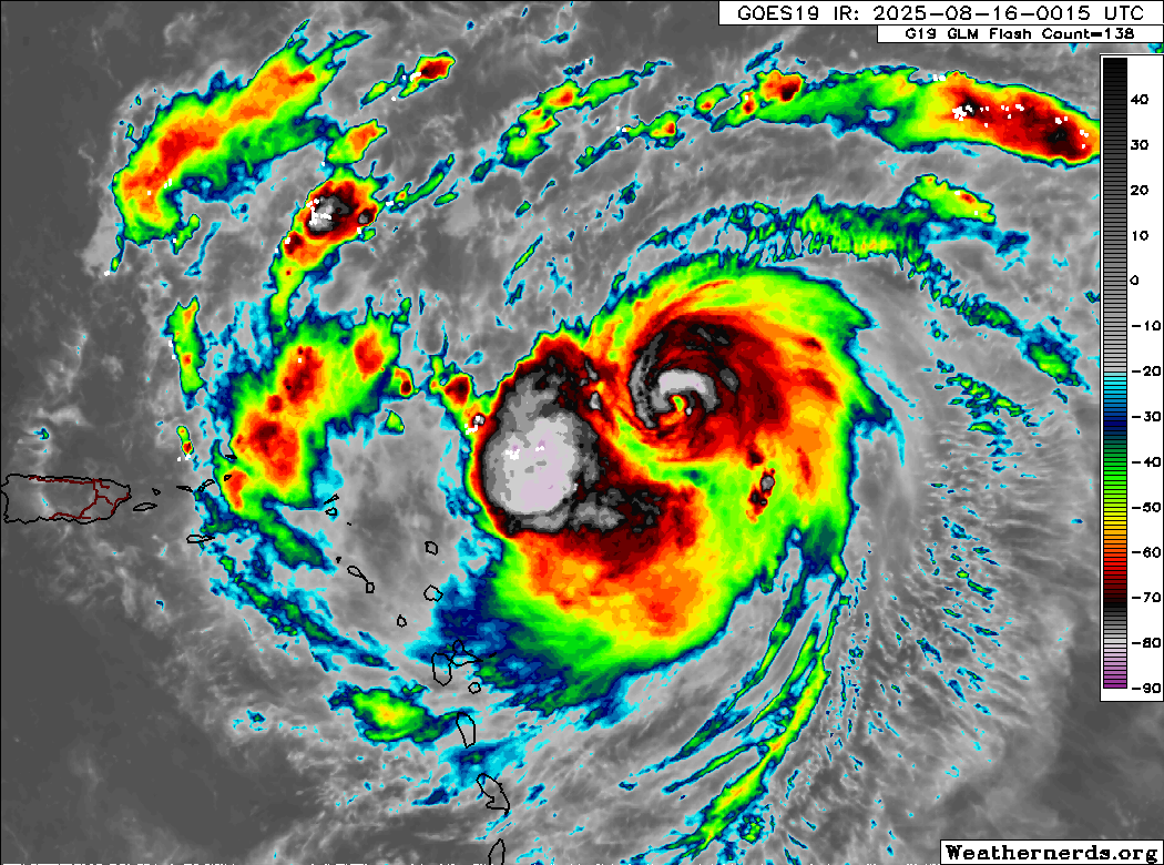
The symmetrization of the wind field today is beautiful.

The upper-level anticyclone is mesmerizing. Will become a textbook major hurricane soon
The upper-level anticyclone is mesmerizing. Will become a textbook major hurricane soon
Last edited by weeniepatrol on Sat Aug 16, 2025 12:20 am, edited 2 times in total.
0 likes
-
CrazyC83
- Professional-Met
- Posts: 34043
- Joined: Tue Mar 07, 2006 11:57 pm
- Location: Deep South, for the first time!
Re: ATL: ERIN - Hurricane - Discussion
Pressure down to 971 mb. It's really taking off now.
000
URNT12 KNHC 160511
VORTEX DATA MESSAGE AL052025
A. 16/04:51:30Z
B. 19.50 deg N 060.15 deg W
C. 700 mb 2882 m
D. 972 mb
E. 110 deg 11 kt
F. CLOSED
G. E36/13/9
H. 74 kt
I. 144 deg 12 nm 04:47:30Z
J. 227 deg 74 kt
K. 144 deg 5 nm 04:49:30Z
L. 81 kt
M. 309 deg 12 nm 04:54:30Z
N. 047 deg 88 kt
O. 308 deg 10 nm 04:54:00Z
P. 10 C / 3041 m
Q. 13 C / 3049 m
R. 8 C / NA
S. 12345 / 7
T. 0.02 / 1 nm
U. AF308 0705A ERIN OB 29
MAX FL WIND 88 KT 308 / 10 NM 04:54:00Z
;
1 likes


Re: ATL: ERIN - Hurricane - Discussion
msbee wrote:FYI, it’s incredibly quiet and still in St Maarten right now.
When 150 mph Hurricane Michael's eye was 30 mies S.of Panama City, FL, in 2018, the wind in PC was 15-20 mph. And yes, that seemed eerily and incredibly quiet. In many typhoons, almost all the wind is concentrated in the wall cloud and inner central core; I have been told by the expert, JL.
Note: in Erin's 11 pm forecast advisory, the extent of 34 kt winds was ony 30 miles in the SW quadrant
MAX SUSTAINED WINDS 85 KT WITH GUSTS TO 105 KT.
64 KT....... 25NE 15SE 10SW 20NW.
50 KT....... 40NE 30SE 15SW 40NW.
34 KT.......110NE 50SE 30SW 100NW.
0 likes
List of 79 tropical cyclones intercepted by Richard Horodner:
http://www.canebeard.com/page/page/572246.htm
former storm2k screenname Beoumont 2009+
http://www.canebeard.com/page/page/572246.htm
former storm2k screenname Beoumont 2009+

Re: ATL: ERIN - Hurricane - Discussion
I suspect Erin is probably right on the cusp of being a major hurricane now
0 likes
Return to “Active Storms/Invests - Atlantic/EastPAC/CentralPAC/MED”
Who is online
Users browsing this forum: Google Adsense [Bot] and 73 guests