https://x.com/AdrianLinares28/status/1956689751945183573
https://x.com/ryanhallyall/status/1956689555597172934
ATL: ERIN - Hurricane - Discussion
Moderators: hurricanetrack, S2k Moderators

The posts in this forum are NOT official forecasts and should not be used as such. They are just the opinion of the poster and may or may not be backed by sound meteorological data. They are NOT endorsed by any professional institution or STORM2K. For official information, please refer to products from the National Hurricane Center and National Weather Service.

-
Hurricane2022

- Category 5

- Posts: 1634
- Joined: Tue Aug 23, 2022 11:38 pm
- Location: Araçatuba, Brazil
Re: ATL: ERIN - Hurricane - Discussion
0 likes
Sorry for the bad English sometimes...!
For reliable and detailed information for any meteorological phenomenon, please consult the National Hurricane Center, Joint Typhoon Warning Center , or your local Meteo Center.
--------
Una cvm Christo, pro Christo, et in Christo. Sit nomen Domini benedictvm.
For reliable and detailed information for any meteorological phenomenon, please consult the National Hurricane Center, Joint Typhoon Warning Center , or your local Meteo Center.
--------
Una cvm Christo, pro Christo, et in Christo. Sit nomen Domini benedictvm.

Re: ATL: ERIN - Hurricane - Discussion
Is EWRC the only thing that can stop Erin from hitting Cat 5 today?
0 likes
-
WaveBreaking

- Category 2

- Posts: 602
- Joined: Sun Jun 30, 2024 11:33 am
- Location: US
Re: ATL: ERIN - Hurricane - Discussion
Teban54 wrote:Is EWRC the only thing that can stop Erin from hitting Cat 5 today?
Either that or surprise mid-level shear a la Lee
0 likes
I am NOT a professional meteorologist, so take all of my posts with a grain of salt. My opinions are mine and mine alone.


Re: ATL: ERIN - Hurricane - Discussion
Erin has been moving almost due west in the past 12 hours.
https://x.com/ndgmetchef/status/1956700104745746454
https://x.com/ndgmetchef/status/1956700104745746454
0 likes
-
WeatherBoy2000
- Category 1

- Posts: 389
- Joined: Mon Apr 10, 2023 9:29 am
Re: ATL: ERIN - Hurricane - Discussion
Best track has this now at 130kts. This marks the 11th year in a row of a season producing a hurricane of at least that intensity.
3 likes
-
mrbagyo

- Category 5
- Posts: 3739
- Age: 33
- Joined: Thu Apr 12, 2012 9:18 am
- Location: 14.13N 120.98E
- Contact:
Re: ATL: ERIN - Hurricane - Discussion
The eye is perfectly clear
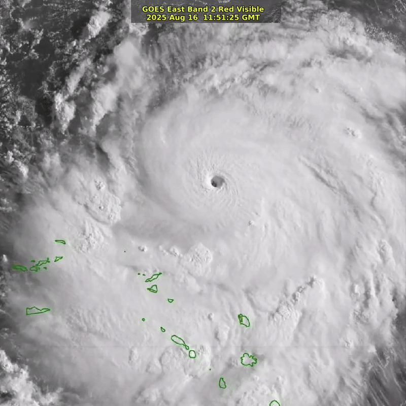
8 likes
The posts in this forum are NOT official forecast and should not be used as such. They are just the opinion of the poster and may or may not be backed by sound meteorological data. They are NOT endorsed by any professional institution or storm2k.org. For official information, please refer to RSMC, NHC and NWS products.
Re: ATL: ERIN - Hurricane - Discussion
San Juan radar loop as the first signs of erin's eye enter the extreme radar range:
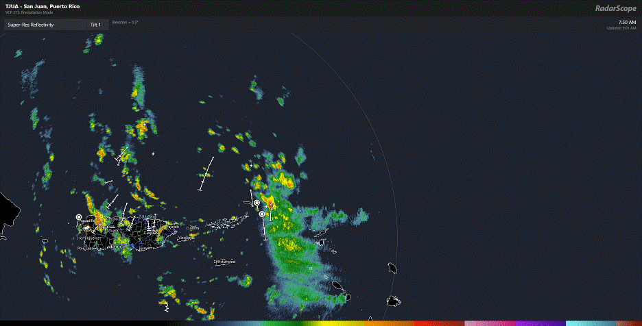
1 likes

Re: ATL: ERIN - Hurricane - Discussion
Looks like lightning getting worse in the eyewall.
Recon about to make a run into the NE Quad.
Recon about to make a run into the NE Quad.
0 likes

Re: ATL: ERIN - Hurricane - Discussion
AF308 should make another pass through Erin in the next half hour. I would not be surprised if it finds a Cat 5. The pressure has probably dropped into the upper 920s by now.
1 likes
Irene '11 Sandy '12 Hermine '16 5/15/2018 Derecho Fay '20 Isaias '20 Elsa '21 Henri '21 Ida '21
I am only a meteorology enthusiast who knows a decent amount about tropical cyclones. Look to the professional mets, the NHC, or your local weather office for the best information.
I am only a meteorology enthusiast who knows a decent amount about tropical cyclones. Look to the professional mets, the NHC, or your local weather office for the best information.

Re: ATL: ERIN - Hurricane - Discussion
A beast awakens

7 likes
Igor 2010, Sandy 2012, Fay 2014, Gonzalo 2014, Joaquin 2015, Nicole 2016, Humberto 2019
I am only a tropical weather enthusiast. My predictions are not official and may or may not be backed by sound meteorological data. For official information, please refer to the NHC and NWS products.
I am only a tropical weather enthusiast. My predictions are not official and may or may not be backed by sound meteorological data. For official information, please refer to the NHC and NWS products.

Re: ATL: ERIN - Hurricane - Discussion
TheDreamTraveler wrote:
I thought she was moving WNW. That looks like a steady due West movement. Not even wobbling or stair stepping. I'm assuming the WNW movement should resume but that's a bit concerning the farther west and south this stays the more likely there may be slight impacts from the outside edges of Erin in the Outer Banks
Perhaps the western jog is due to its strong outflow pumping the ridge to its east. I expect Erin to resume its WNW track in earnest at some point today, though.
Last edited by abajan on Sat Aug 16, 2025 8:21 am, edited 1 time in total.
1 likes
-
weeniepatrol

- Category 5
- Posts: 1296
- Joined: Sat Aug 22, 2020 5:30 pm
- Location: WA State
-
WaveBreaking
- Category 2
- Posts: 602
- Joined: Sun Jun 30, 2024 11:33 am
- Location: US
Re: ATL: ERIN - Hurricane - Discussion
Sunrise


9 likes
I am NOT a professional meteorologist, so take all of my posts with a grain of salt. My opinions are mine and mine alone.
Re: ATL: ERIN - Hurricane - Discussion
abajan wrote:TheDreamTraveler wrote:
I thought she was moving WNW. That looks like a steady due West movement. Not even wobbling or stair stepping. I'm assuming the WNW movement should resume but that's a bit concerning the farther west and south this stays the more likely there may be slight impacts from the outside edges of Erin in the Outer Banks
Perhaps western jog is due to its strong outflow pumping the ridge to its east. I expect Erin to resume its WNW track in earnest at some point today, though.
Steering currents about 12hrs ago showed the forcing to be due west influenced by a ridge over FL.
If this is true, then Erin maybe be moving more into the Bahamas than currently forecast.
1 likes
Re: ATL: ERIN - Hurricane - Discussion
WeatherBoy2000 wrote:Best track has this now at 130kts. This marks the 11th year in a row of a season producing a hurricane of at least that intensity.
Yep:
AL, 05, 2025081612, , BEST, 0, 196N, 621W, 130, 934, HU
Earlier this morning, I considered the possibility of Erin hitting Cat5 by sometime this afternoon. Now, that intensity being reached in time for the next advisory later this morning seems within the realm of possibility. Heck, at this rate of intensification it even seems likely.
3 likes
Re: ATL: ERIN - Hurricane - Discussion
Forecast yesterday afternoon (8/15 5pm ET): 90 kts at 18z, 5 hours from now
Now: 125 kts official advisory, 130 kts best track
Now: 125 kts official advisory, 130 kts best track
1 likes

Re: ATL: ERIN - Hurricane - Discussion
AF308, 925.0 mb extrapolated with 28 kt nearby -> 922/923 mb.
145 kt FL and 160 SFMR. The FL wind would translate to 130 kt. Combined with the SFMR I'd say 135 kt, but I'm pretty such Erin is a cat 5 or very very close to one. It's just a matter of finding the pocket of peak FL winds somewhere in the core. Either way, if AF308 performs 1 or 2 more passes I'm confident those winds will be found.
145 kt FL and 160 SFMR. The FL wind would translate to 130 kt. Combined with the SFMR I'd say 135 kt, but I'm pretty such Erin is a cat 5 or very very close to one. It's just a matter of finding the pocket of peak FL winds somewhere in the core. Either way, if AF308 performs 1 or 2 more passes I'm confident those winds will be found.
3 likes
-
Hurricane2022
- Category 5
- Posts: 1634
- Joined: Tue Aug 23, 2022 11:38 pm
- Location: Araçatuba, Brazil
Re: ATL: ERIN - Hurricane - Discussion
925.0 extrap 
2 likes
Sorry for the bad English sometimes...!
For reliable and detailed information for any meteorological phenomenon, please consult the National Hurricane Center, Joint Typhoon Warning Center , or your local Meteo Center.
--------
Una cvm Christo, pro Christo, et in Christo. Sit nomen Domini benedictvm.
For reliable and detailed information for any meteorological phenomenon, please consult the National Hurricane Center, Joint Typhoon Warning Center , or your local Meteo Center.
--------
Una cvm Christo, pro Christo, et in Christo. Sit nomen Domini benedictvm.
Re: ATL: ERIN - Hurricane - Discussion
The two recon planes about to cross the eye at the same time.
A wing wave would be nice.
A wing wave would be nice.
2 likes
Return to “Active Storms/Invests - Atlantic/EastPAC/CentralPAC/MED”
Who is online
Users browsing this forum: No registered users and 124 guests