
ATL: ERIN - Hurricane - Discussion
Moderators: hurricanetrack, S2k Moderators

The posts in this forum are NOT official forecasts and should not be used as such. They are just the opinion of the poster and may or may not be backed by sound meteorological data. They are NOT endorsed by any professional institution or STORM2K. For official information, please refer to products from the National Hurricane Center and National Weather Service.

-
Hurricane2022

- Category 5

- Posts: 1631
- Joined: Tue Aug 23, 2022 11:38 pm
- Location: Araçatuba, Brazil
Re: ATL: ERIN - Hurricane - Discussion
Of course the hurricane is going to "explode" again just after recon leaves it
4 likes
Sorry for the bad English sometimes...!
For reliable and detailed information for any meteorological phenomenon, please consult the National Hurricane Center, Joint Typhoon Warning Center , or your local Meteo Center.
--------
Una cvm Christo, pro Christo, et in Christo. Sit nomen Domini benedictvm.
For reliable and detailed information for any meteorological phenomenon, please consult the National Hurricane Center, Joint Typhoon Warning Center , or your local Meteo Center.
--------
Una cvm Christo, pro Christo, et in Christo. Sit nomen Domini benedictvm.
-
cheezyWXguy

- Category 5
- Posts: 6127
- Joined: Mon Feb 13, 2006 12:29 am
- Location: Dallas, TX
Re: ATL: ERIN - Hurricane - Discussion
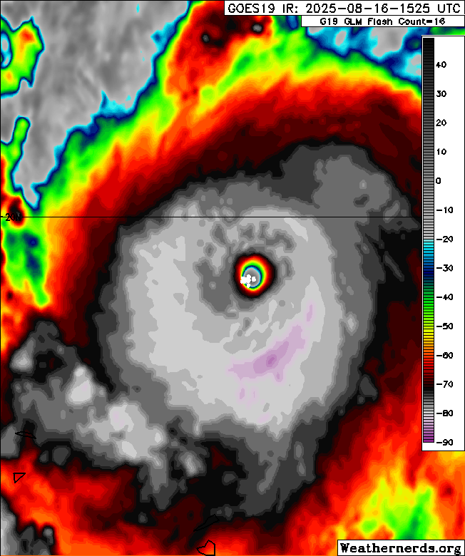
Cdo cloud tops continuing to cool while the eye remains stable…for now. Erin may be able to eek out a bit more intensification before fully leveling off.
4 likes

Re: ATL: ERIN - Hurricane - Discussion
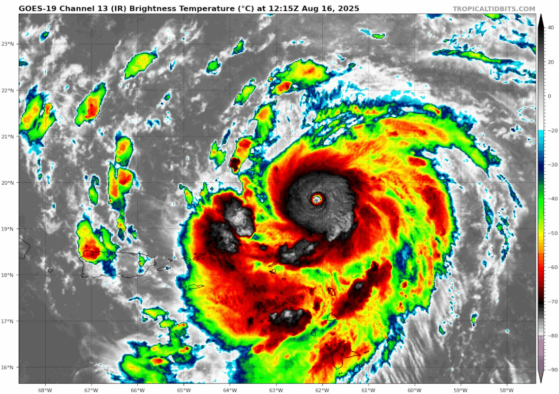
Looks like the CDO has become less symmetric in the last hour or so. Is there a slight uptick in shear, or is this only due to Erin's motion and/or possible EWRC attempts?
1 likes
-
Cachondo23
- Tropical Depression

- Posts: 96
- Joined: Wed May 25, 2022 5:56 am
Re: ATL: ERIN - Hurricane - Discussion
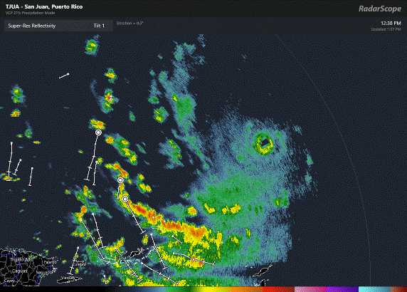
Erin seems to be wobbling a bit back west on the radar, the eye may be shrinking also. Not the best on this long range since the radar is seeing so high in the air, but WNW overall still.
0 likes

Re: ATL: ERIN - Hurricane - Discussion
Teban54 wrote:Looks like the CDO has become less symmetric in the last hour or so. Is there a slight uptick in shear, or is this only due to Erin's motion and/or possible EWRC attempts?
https://i.postimg.cc/5NjRD2fS/goes19-ir-05-L-202508161215.gif
I suspect it could be due to the upcoming EWRC and the outer eyewall getting established. I recall many other upper-echelon Atlantic systems have shown a similar structural change ahead of an EWRC.
0 likes
Irene '11 Sandy '12 Hermine '16 5/15/2018 Derecho Fay '20 Isaias '20 Elsa '21 Henri '21 Ida '21
I am only a meteorology enthusiast who knows a decent amount about tropical cyclones. Look to the professional mets, the NHC, or your local weather office for the best information.
I am only a meteorology enthusiast who knows a decent amount about tropical cyclones. Look to the professional mets, the NHC, or your local weather office for the best information.
-
bob rulz
- Category 5
- Posts: 1705
- Age: 35
- Joined: Sat Jan 28, 2006 7:30 pm
- Location: Salt Lake City, Utah
Re: ATL: ERIN - Hurricane - Discussion
Can't keep your eyes off of a hurricane even overnight these days....I saw it had just made hurricane status last time I checked yesterday, then when I was checking the news I saw "Hurricane Erin reaches category 5 intensity" and I literally yelled "excuse me, what?" out loud to myself.
I'm glad this one seems like it will have minimal land impacts.
I'm glad this one seems like it will have minimal land impacts.
3 likes
-
Craters
- Category 1

- Posts: 424
- Joined: Sat Aug 24, 2013 2:34 pm
- Location: Alvin, TX (south of Houston)
Re: ATL: ERIN - Hurricane - Discussion
weeniepatrol wrote:https://imgur.com/bqXXTrc
That sure is an uncomfortable reminder of the head fake to the north that Ike threw at roughly the same longitude before it headed toward the Gulf...
https://www.nhc.noaa.gov/archive/2008/graphics/al09/loop_5W.shtml
1 likes
Nothing that I post here should ever be treated as a forecast or anything resembling one. Please check with your local NWS office or the NHC for forecasts, watches, and warnings.
-
Craters
- Category 1
- Posts: 424
- Joined: Sat Aug 24, 2013 2:34 pm
- Location: Alvin, TX (south of Houston)
Re: ATL: ERIN - Hurricane - Discussion
GCANE wrote:The two recon planes about to cross the eye at the same time.
A wing wave would be nice.
Just keeping the wings attached would be even nicer...
4 likes
Nothing that I post here should ever be treated as a forecast or anything resembling one. Please check with your local NWS office or the NHC for forecasts, watches, and warnings.
-
AxaltaRacing24
- Category 5
- Posts: 1764
- Age: 25
- Joined: Wed Jul 27, 2016 11:14 am
- Location: Jupiter, FL
Re: ATL: ERIN - Hurricane - Discussion
Craters wrote:weeniepatrol wrote:https://imgur.com/bqXXTrc
That sure is an uncomfortable reminder of the head fake to the north that Ike threw at roughly the same longitude before it headed toward the Gulf...
https://www.nhc.noaa.gov/archive/2008/graphics/al09/loop_5W.shtml
Forecasting has come a LONG way since then
3 likes
-
cycloneye

- Admin

- Posts: 146098
- Age: 69
- Joined: Thu Oct 10, 2002 10:54 am
- Location: San Juan, Puerto Rico
Re: ATL: ERIN - Hurricane - Discussion
0 likes
Visit the Caribbean-Central America Weather Thread where you can find at first post web cams,radars
and observations from Caribbean basin members Click Here
and observations from Caribbean basin members Click Here
Re: ATL: ERIN - Hurricane - Discussion
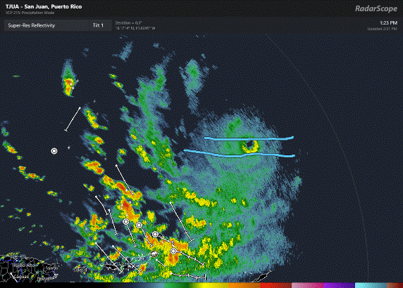
Another radar loop, this time with poorly drawn parallel lines to assist the wobble watchers.
1 likes
-
Craters
- Category 1
- Posts: 424
- Joined: Sat Aug 24, 2013 2:34 pm
- Location: Alvin, TX (south of Houston)
Re: ATL: ERIN - Hurricane - Discussion
Food for thought?
Just for the heck of it, I submitted this request to Microsoft Copilot: "Provide a plot of average hurricane intensity on the Saffir-Simpson scale as a function of the solar Ap-index (independent variable) over the past 50 years." Here's what it came up with:

That came after I remembered GCANE's posts last year regarding solar activity and hurricane intensification. The solar Ap-index is only one variable of about a zillion and a half, but it's still kind of interesting. The color gradient supposedly represents the year of observation, but it didn't provide a scale.
For what it's worth, anyway...
Just for the heck of it, I submitted this request to Microsoft Copilot: "Provide a plot of average hurricane intensity on the Saffir-Simpson scale as a function of the solar Ap-index (independent variable) over the past 50 years." Here's what it came up with:
That came after I remembered GCANE's posts last year regarding solar activity and hurricane intensification. The solar Ap-index is only one variable of about a zillion and a half, but it's still kind of interesting. The color gradient supposedly represents the year of observation, but it didn't provide a scale.
For what it's worth, anyway...
0 likes
Nothing that I post here should ever be treated as a forecast or anything resembling one. Please check with your local NWS office or the NHC for forecasts, watches, and warnings.
-
tropicwatch

- Category 5
- Posts: 3399
- Age: 61
- Joined: Sat Jun 02, 2007 10:01 am
- Location: Panama City Florida
- Contact:
Re: ATL: ERIN - Hurricane - Discussion
Looks like Erin will come relatively close to buoy 41043 which is currently reporting close to 18ft seas. It will be fun to watch the readings out of it as the day progresses. 
https://www.ndbc.noaa.gov/station_page.php?station=41043
https://www.ndbc.noaa.gov/station_page.php?station=41043
0 likes
Tropicwatch
Agnes 72', Eloise 75, Elena 85', Kate 85', Charley 86', Florence 88', Beryl 94', Dean 95', Erin 95', Opal 95', Earl 98', Georges 98', Ivan 2004', Arlene 2005', Dennis 2005', Ida 2009' Debby 2012' Irma 2017' Michael 2018'
Agnes 72', Eloise 75, Elena 85', Kate 85', Charley 86', Florence 88', Beryl 94', Dean 95', Erin 95', Opal 95', Earl 98', Georges 98', Ivan 2004', Arlene 2005', Dennis 2005', Ida 2009' Debby 2012' Irma 2017' Michael 2018'
-
cycloneye
- Admin
- Posts: 146098
- Age: 69
- Joined: Thu Oct 10, 2002 10:54 am
- Location: San Juan, Puerto Rico
Re: ATL: ERIN - Hurricane - Discussion
AL, 05, 2025081618, , BEST, 0, 198N, 634W, 140, 915, HU

4 likes
Visit the Caribbean-Central America Weather Thread where you can find at first post web cams,radars
and observations from Caribbean basin members Click Here
and observations from Caribbean basin members Click Here
-
Iceresistance

- Category 5
- Posts: 9296
- Age: 21
- Joined: Sat Oct 10, 2020 9:45 am
- Location: Tecumseh, OK/Norman, OK
Re: ATL: ERIN - Hurricane - Discussion
3 likes
Bill 2015 & Beta 2020
Winter 2020-2021
All observations are in Tecumseh, OK unless otherwise noted.
Winter posts are focused mainly for Oklahoma & Texas.
Take any of my forecasts with a grain of salt, refer to the NWS, SPC, and NHC for official information
Never say Never with weather! Because ANYTHING is possible!
Winter 2020-2021
All observations are in Tecumseh, OK unless otherwise noted.
Winter posts are focused mainly for Oklahoma & Texas.
Take any of my forecasts with a grain of salt, refer to the NWS, SPC, and NHC for official information
Never say Never with weather! Because ANYTHING is possible!
-
HurricaneIrma
- Tropical Low

- Posts: 41
- Age: 44
- Joined: Mon Sep 03, 2018 9:37 am
- Location: Wilmington NC
Re: ATL: ERIN - Hurricane - Discussion
BobHarlem wrote:Erin seems to be wobbling a bit back west on the radar, the eye may be shrinking also. Not the best on this long range since the radar is seeing so high in the air, but WNW overall still.
https://i.postimg.cc/wTjwcyMw/Radar-Scope-Export-20250816-133721.gif
The NHC is now saying westward now
1 likes


Re: ATL: ERIN - Hurricane - Discussion
like yeah...i know it is going to turn, every model says it is going to turn but if i was in Puerto Rico right now...i'd be having my doubts right now
like if it was this close to cocoa beach, i would bepooping myself in East Orlando rn lol
like if it was this close to cocoa beach, i would be
0 likes
Just like Jon Snow..."I know nothing" except what I know, and most of what I know is gathered by the fine people of the NHC
-
FrontRunner
- Tropical Depression
- Posts: 66
- Age: 41
- Joined: Wed Aug 23, 2006 9:01 pm
- Location: Westchester, NY
Re: ATL: ERIN - Hurricane - Discussion
CDO looking healthier after a brief hiccup. Anyone got an ETA on the next center fix?
1 likes
Re: ATL: ERIN - Hurricane - Discussion
Iceresistance wrote:Erin has been moving more west in the past several frames
https://s14.gifyu.com/images/bN014.gif
https://s14.gifyu.com/images/bN014.gif
CDO has improved too, maybe the EWRC isn’t as imminent as I thought. Hopefully it keeps this up for the next center fix in a few hours.
Based on the last fix and its slightly better appearance, I think 145/913 could be a good estimate.
2 likes
Irene '11 Sandy '12 Hermine '16 5/15/2018 Derecho Fay '20 Isaias '20 Elsa '21 Henri '21 Ida '21
I am only a meteorology enthusiast who knows a decent amount about tropical cyclones. Look to the professional mets, the NHC, or your local weather office for the best information.
I am only a meteorology enthusiast who knows a decent amount about tropical cyclones. Look to the professional mets, the NHC, or your local weather office for the best information.
Return to “Active Storms/Invests - Atlantic/EastPAC/CentralPAC/MED”
Who is online
Users browsing this forum: 'CaneFreak and 79 guests