

ATL: ERIN - Hurricane - Discussion
Moderators: hurricanetrack, S2k Moderators

The posts in this forum are NOT official forecasts and should not be used as such. They are just the opinion of the poster and may or may not be backed by sound meteorological data. They are NOT endorsed by any professional institution or STORM2K. For official information, please refer to products from the National Hurricane Center and National Weather Service.

Re: ATL: ERIN - Hurricane - Discussion
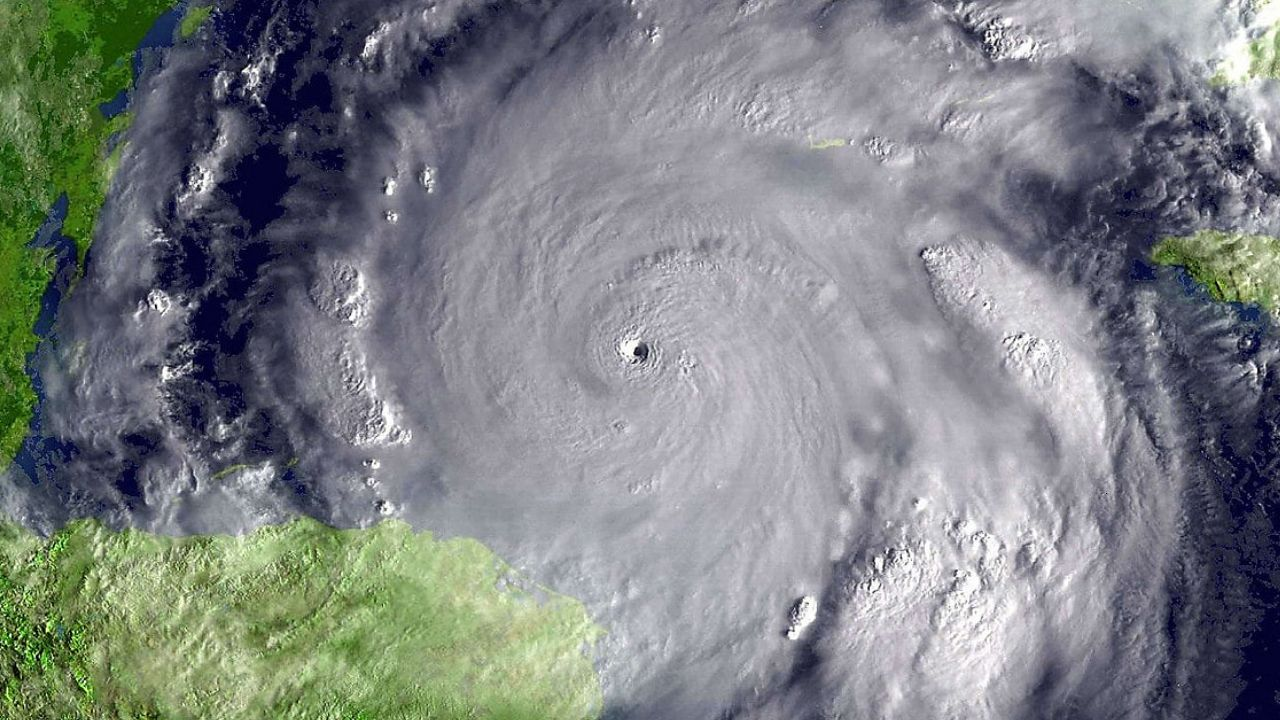
How small did Erin's eye get?? Looked on vis satellite almost as small as Wilma when she was 2 miles.
Last edited by canebeard on Sat Aug 16, 2025 4:37 pm, edited 1 time in total.
3 likes
List of 79 tropical cyclones intercepted by Richard Horodner:
http://www.canebeard.com/page/page/572246.htm
former storm2k screenname Beoumont 2009+
http://www.canebeard.com/page/page/572246.htm
former storm2k screenname Beoumont 2009+


Re: ATL: ERIN - Hurricane - Discussion
Watching radar closely.
Inner eyewall maybe opening up.
Inner eyewall maybe opening up.
1 likes
-
Hurricane2022

- Category 5

- Posts: 1634
- Joined: Tue Aug 23, 2022 11:38 pm
- Location: Araçatuba, Brazil
Re: ATL: ERIN - Hurricane - Discussion
Eyewall may be opening up on Radar
1 likes
Sorry for the bad English sometimes...!
For reliable and detailed information for any meteorological phenomenon, please consult the National Hurricane Center, Joint Typhoon Warning Center , or your local Meteo Center.
--------
Una cvm Christo, pro Christo, et in Christo. Sit nomen Domini benedictvm.
For reliable and detailed information for any meteorological phenomenon, please consult the National Hurricane Center, Joint Typhoon Warning Center , or your local Meteo Center.
--------
Una cvm Christo, pro Christo, et in Christo. Sit nomen Domini benedictvm.
Re: ATL: ERIN - Hurricane - Discussion
San Juan is going to get whacked by that feeder band in a couple hours
0 likes
-
Hurricane2022
- Category 5
- Posts: 1634
- Joined: Tue Aug 23, 2022 11:38 pm
- Location: Araçatuba, Brazil
Re: ATL: ERIN - Hurricane - Discussion
6 likes
Sorry for the bad English sometimes...!
For reliable and detailed information for any meteorological phenomenon, please consult the National Hurricane Center, Joint Typhoon Warning Center , or your local Meteo Center.
--------
Una cvm Christo, pro Christo, et in Christo. Sit nomen Domini benedictvm.
For reliable and detailed information for any meteorological phenomenon, please consult the National Hurricane Center, Joint Typhoon Warning Center , or your local Meteo Center.
--------
Una cvm Christo, pro Christo, et in Christo. Sit nomen Domini benedictvm.
Re: ATL: ERIN - Hurricane - Discussion
Wish We could’ve gotten an official size of that eye right now
0 likes
Re: ATL: ERIN - Hurricane - Discussion
Looks like the eye is closing back up.
Must have been a bad taco.
Must have been a bad taco.
2 likes
-
cheezyWXguy

- Category 5
- Posts: 6127
- Joined: Mon Feb 13, 2006 12:29 am
- Location: Dallas, TX
Re: ATL: ERIN - Hurricane - Discussion
GCANE wrote:Looks like the eye is closing back up.
Must have been a bad taco.
Lol. Yeah at that distance and height attenuation is probably occurring. Still looks intact to me, but that outer eyewall is showing up now. Looks to be about 25nm across.
2 likes
Re: ATL: ERIN - Hurricane - Discussion
cheezyWXguy wrote:GCANE wrote:Looks like the eye is closing back up.
Must have been a bad taco.
Lol. Yeah at that distance and height attenuation is probably occurring. Still looks intact to me, but that outer eyewall is showing up now. Looks to be about 25nm across.
CDO is contacting too.
0 likes
-
Sciencerocks
- Category 5
- Posts: 9289
- Age: 39
- Joined: Thu Jul 06, 2017 1:51 am


Re: ATL: ERIN - Hurricane - Discussion
cheezyWXguy wrote:GCANE wrote:Looks like the eye is closing back up.
Must have been a bad taco.
Lol. Yeah at that distance and height attenuation is probably occurring. Still looks intact to me, but that outer eyewall is showing up now. Looks to be about 25nm across.
If an EWRC began around 20~21z, as the NHC's discussion suggested, I doubt the inner eyewall would have fully collapsed after only an hour or two. Weakening may have already started if the eyewall is no longer closed; if it's still intact - which is possible - pressure could be around the same as it was at the time of the previous flight's final center fix, or even lower. But we're at an uncertain point in the storm's "life cycle". If the forecast is to be believed, conditions remain favourable enough for some recovery from the current EWRC. Hurricanes have bounced back from worse.
1 likes
-
Hurricane2022
- Category 5
- Posts: 1634
- Joined: Tue Aug 23, 2022 11:38 pm
- Location: Araçatuba, Brazil
Re: ATL: ERIN - Hurricane - Discussion
1 likes
Sorry for the bad English sometimes...!
For reliable and detailed information for any meteorological phenomenon, please consult the National Hurricane Center, Joint Typhoon Warning Center , or your local Meteo Center.
--------
Una cvm Christo, pro Christo, et in Christo. Sit nomen Domini benedictvm.
For reliable and detailed information for any meteorological phenomenon, please consult the National Hurricane Center, Joint Typhoon Warning Center , or your local Meteo Center.
--------
Una cvm Christo, pro Christo, et in Christo. Sit nomen Domini benedictvm.
-
Hurricane2022
- Category 5
- Posts: 1634
- Joined: Tue Aug 23, 2022 11:38 pm
- Location: Araçatuba, Brazil
Re: ATL: ERIN - Hurricane - Discussion
0 likes
Sorry for the bad English sometimes...!
For reliable and detailed information for any meteorological phenomenon, please consult the National Hurricane Center, Joint Typhoon Warning Center , or your local Meteo Center.
--------
Una cvm Christo, pro Christo, et in Christo. Sit nomen Domini benedictvm.
For reliable and detailed information for any meteorological phenomenon, please consult the National Hurricane Center, Joint Typhoon Warning Center , or your local Meteo Center.
--------
Una cvm Christo, pro Christo, et in Christo. Sit nomen Domini benedictvm.
-
TomballEd
- Category 3

- Posts: 807
- Age: 61
- Joined: Wed Aug 16, 2023 4:52 pm
- Location: Spring/Klein area, not Tomball
Re: ATL: ERIN - Hurricane - Discussion
I don't see the clear double wind max but I think this is approaching peak. They eye has gotten very small and I think last few frames it might be getting obscured.
0 likes
Re: ATL: ERIN - Hurricane - Discussion
I know I keep saying this, but it’s really disappointing that we never know the true size of the eye before collapse
1 likes
Return to “Active Storms/Invests - Atlantic/EastPAC/CentralPAC/MED”
Who is online
Users browsing this forum: No registered users and 143 guests