
ATL: Ex INVEST 91L - Discussion (0/0)
Moderators: hurricanetrack, S2k Moderators

The posts in this forum are NOT official forecasts and should not be used as such. They are just the opinion of the poster and may or may not be backed by sound meteorological data. They are NOT endorsed by any professional institution or STORM2K. For official information, please refer to products from the National Hurricane Center and National Weather Service.

-
cycloneye

- Admin

- Posts: 146550
- Age: 69
- Joined: Thu Oct 10, 2002 10:54 am
- Location: San Juan, Puerto Rico
Re: ATL: INVEST 91L - Discussion (30/60)
Maybe a small increase of convection but not too much.
0 likes
Visit the Caribbean-Central America Weather Thread where you can find at first post web cams,radars
and observations from Caribbean basin members Click Here
and observations from Caribbean basin members Click Here
-
wzrgirl1

- S2K Supporter

- Posts: 1338
- Joined: Sat Sep 04, 2004 6:44 am
- Location: Pembroke Pines, Florida
Re: ATL: INVEST 91L - Discussion (30/60)
I still think it’s going to come back and form middle of next week. It’s not over till it’s over.
1 likes
-
emeraldislenc
- Category 2

- Posts: 578
- Joined: Fri Aug 24, 2012 4:49 pm
- Location: Emerald Isle NC
Re: ATL: INVEST 91L - Discussion (30/60)
I agree still have to watch it. Too many people are saying "next." But I think we should keep a watchful eye.
0 likes

Re: ATL: INVEST 91L - Discussion (30/60)
It's taken a step backward in development over the past 12 hours. The vorticity signature looks worse and the dry air infront is clearly hindering convection. Maybe it gets it's act together later in the Subtropics? A lot would need to happen quickly for this to threaten the islands now.


0 likes

Re: ATL: INVEST 91L - Discussion (30/60)
The long-awaited convection at 12N finally appeared, except that to my untrained eye, they seem offset to the west of the low-level features.
0 likes
-
AutoPenalti
- Category 5

- Posts: 4072
- Age: 29
- Joined: Mon Aug 17, 2015 4:16 pm
- Location: Ft. Lauderdale, Florida
Re: ATL: INVEST 91L - Discussion (30/60)
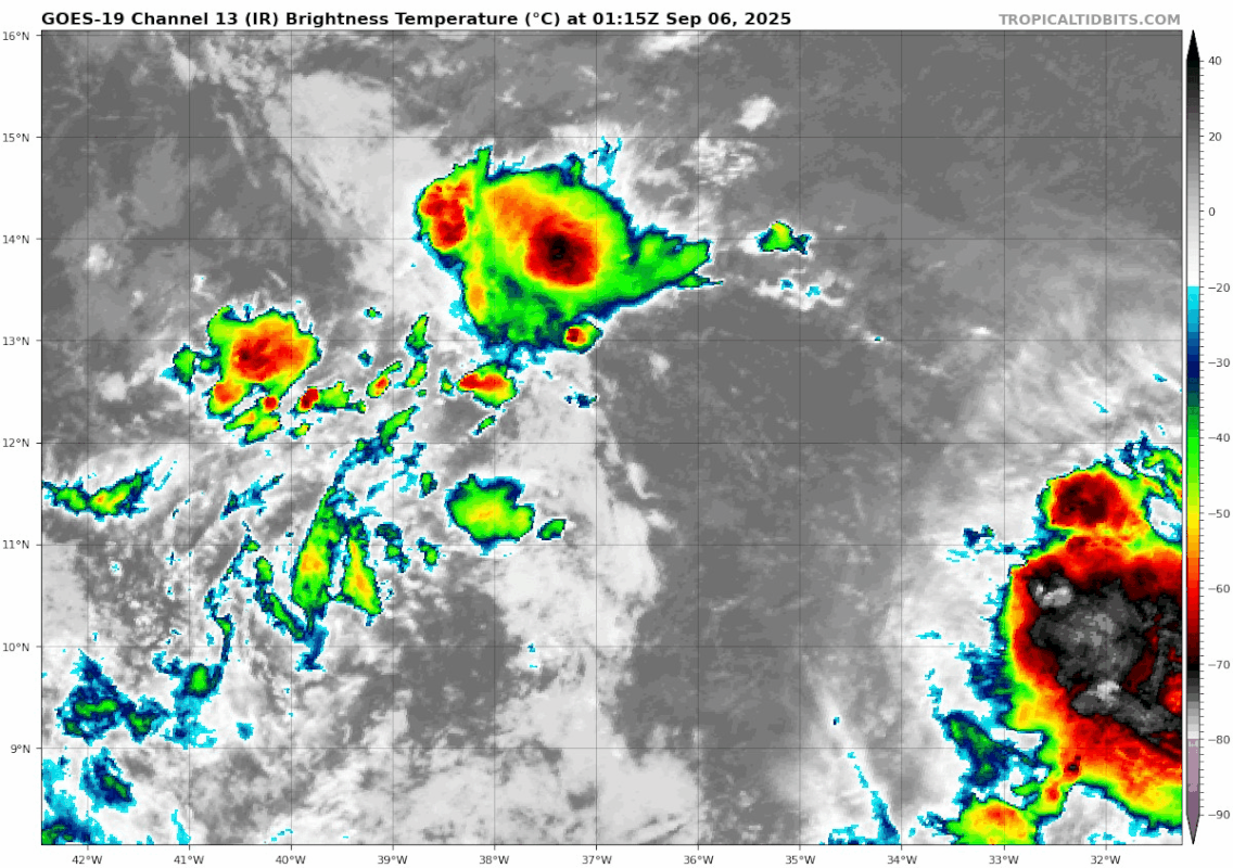
Teban54 wrote:The long-awaited convection at 12N finally appeared, except that to my untrained eye, they seem offset to the west of the low-level features.
https://i.postimg.cc/L5G0qV1y/goes19-ir-91-L-202509060115.gif
Entering DMIN, so have to wait and see.
0 likes
The posts in this forum are NOT official forecasts and should not be used as such. They are just the opinion of the poster and may or may not be backed by sound meteorological data. They are NOT endorsed by any professional institution or STORM2K. For official information, please refer to products from the NHC and NWS.
Model Runs Cheat Sheet:
GFS (5:30 AM/PM, 11:30 AM/PM)
HWRF, GFDL, UKMET, NAVGEM (6:30-8:00 AM/PM, 12:30-2:00 AM/PM)
ECMWF (1:45 AM/PM)
TCVN is a weighted averaged

Re: ATL: INVEST 91L - Discussion (30/60)
ASCAT shows a day without convection has significantly degraded whatever circulation 91L was attempting to develop:

Convection does seem to be increasing over the past few hours as DMIN approaches but it is still displaced northwest of the broad low level circulation. 91L's not quite dead yet but its heading that way if it can't maintain convection near its broad LLC, which most models show it failing to do over the next few days.
Convection does seem to be increasing over the past few hours as DMIN approaches but it is still displaced northwest of the broad low level circulation. 91L's not quite dead yet but its heading that way if it can't maintain convection near its broad LLC, which most models show it failing to do over the next few days.
0 likes
-
ouragans

- Category 1

- Posts: 498
- Age: 53
- Joined: Sun Jun 12, 2011 12:09 pm
- Location: Abymes, Guadeloupe F.W.I
- Contact:
Re: ATL: INVEST 91L - Discussion (30/60)
Tropical Atlantic (AL91):
Shower and thunderstorm activity remains limited in association with
a tropical wave over the central tropical Atlantic. A drier air mass
is limiting the potential for development over the next couple of
days, and environmental conditions will remain only marginally
favorable thereafter. A tropical depression could form during the
early to middle part of next week as the system moves westward at
around 10 mph across the central tropical Atlantic. This system is
likely to be near the Lesser Antilles by the middle to latter part
of next week, and interests there should monitor its progress.
* Formation chance through 48 hours...low...30 percent.
* Formation chance through 7 days...medium...60 percent.
0 likes
Personal forecast disclaimer
This post is a personal point of view, not an information. Please refer to official statements for life-threatening decisions.
David '79, Frederic '79, Hugo '89, Iris, Luis & Marilyn '95, Georges '98, Lenny '99, Dean '07, Irma '17, Maria '17, Fiona '22, Philippe '23, Tammy '23
16°13'33.3,"6N -61°36'39.5"W

-
jlauderdal
- S2K Supporter
- Posts: 7217
- Joined: Wed May 19, 2004 5:46 am
- Location: NE Fort Lauderdale
- Contact:
Re: ATL: INVEST 91L - Discussion (30/60)
Or a false start, 5 yard penalty. ACE is down and so is post count on this board
1 likes

Re: ATL: INVEST 91L - Discussion (30/60)
Oceansat is showing a nice closed circulation.
This is sitting in a low-shear environment, so convection at this point will be limited.
Waiting to see if it taps into the high moist air from the Amazon which will be around 50W.
Going to be a couple days.
Models hate it, but they have a bad record on development.
This is sitting in a low-shear environment, so convection at this point will be limited.
Waiting to see if it taps into the high moist air from the Amazon which will be around 50W.
Going to be a couple days.
Models hate it, but they have a bad record on development.
0 likes
Re: ATL: INVEST 91L - Discussion (30/60)
Has convection firing along a dryline.
Very typical of a pouch moving thru the MDR at this point.
Very typical of a pouch moving thru the MDR at this point.
0 likes
-
cycloneye
- Admin
- Posts: 146550
- Age: 69
- Joined: Thu Oct 10, 2002 10:54 am
- Location: San Juan, Puerto Rico
Re: ATL: INVEST 91L - Discussion (30/30)
Chances are decreasing for a TD to form.
Tropical Weather Outlook
NWS National Hurricane Center Miami FL
800 AM EDT Sat Sep 6 2025
For the North Atlantic...Caribbean Sea and the Gulf of America:
Tropical Atlantic (AL91):
A tropical wave over the central tropical Atlantic is producing a
small area of disorganized showers and thunderstorms. Environmental
conditions are only marginally conducive for development, and the
chances of this system becoming a tropical depression are
decreasing. The wave is expected to move generally westward at 10
to 15 mph, and will likely be near the Lesser Antilles by the middle
part of next week. Interests there should monitor its progress.
* Formation chance through 48 hours...low...30 percent.
* Formation chance through 7 days...low...30 percent.
$$
Forecaster Roberts/Pasch
0 likes
Visit the Caribbean-Central America Weather Thread where you can find at first post web cams,radars
and observations from Caribbean basin members Click Here
and observations from Caribbean basin members Click Here
-
cycloneye
- Admin
- Posts: 146550
- Age: 69
- Joined: Thu Oct 10, 2002 10:54 am
- Location: San Juan, Puerto Rico
Re: ATL: INVEST 91L - Discussion (20/20)
Tropical Weather Outlook
NWS National Hurricane Center Miami FL
200 PM EDT Sat Sep 6 2025
For the North Atlantic...Caribbean Sea and the Gulf of America:
Tropical Atlantic (AL91):
A tropical wave over the central tropical Atlantic is producing a
small area of shower activity. Environmental conditions are only
marginally conducive for development, and the chances of this
system becoming a tropical depression continue to diminish. The
wave is expected to move generally westward at 10 to 15 mph, and
will likely be near the Lesser Antilles by the middle part of next
week. Interests there should monitor its progress.
* Formation chance through 48 hours...low...20 percent.
* Formation chance through 7 days...low...20 percent.
$$
Forecaster Roberts
0 likes
Visit the Caribbean-Central America Weather Thread where you can find at first post web cams,radars
and observations from Caribbean basin members Click Here
and observations from Caribbean basin members Click Here
-
Hypercane_Kyle

- Category 5
- Posts: 3389
- Joined: Sat Mar 07, 2015 7:58 pm
- Location: Cape Canaveral, FL
Re: ATL: INVEST 91L - Discussion (20/20)
Pretty spectacular model fail across the board on this one. Total ghost storm.
1 likes
My posts are my own personal opinion, defer to the National Hurricane Center (NHC) and other NOAA products for decision making during hurricane season.
-
galaxy401

- Category 5
- Posts: 2426
- Age: 30
- Joined: Sat Aug 25, 2012 9:04 pm
- Location: Casa Grande, Arizona
Re: ATL: INVEST 91L - Discussion (20/20)
Not a good look for the Atlantic to have a disturbance in the MDR region in early September and have unfavorable conditions.
Power of the unfavorable MJO.
Power of the unfavorable MJO.
0 likes
Got my eyes on moving right into Hurricane Alley: Florida.
Re: ATL: INVEST 91L - Discussion (20/20)
galaxy401 wrote:Not a good look for the Atlantic to have a disturbance in the MDR region in early September and have unfavorable conditions.
Power of the unfavorable MJO.
Interestingly, the MJO isn’t unfavorable. It’s currently in phase 2 and has been since Sep 2.
http://www.bom.gov.au/climate/mjo/#tabs=Monitoring
2 likes
Personal Forecast Disclaimer:
The posts in this forum are NOT official forecasts and should not be used as such. They are just the opinion of the poster and may or may not be backed by sound meteorological data. They are NOT endorsed by any professional institution or storm2k.org. For official information, please refer to the NHC and NWS products.
The posts in this forum are NOT official forecasts and should not be used as such. They are just the opinion of the poster and may or may not be backed by sound meteorological data. They are NOT endorsed by any professional institution or storm2k.org. For official information, please refer to the NHC and NWS products.
-
MEANINGLESS_NUMBERS
- Category 1
- Posts: 367
- Joined: Mon Nov 02, 2020 1:43 pm
Re: ATL: INVEST 91L - Discussion (20/20)
Hypercane_Kyle wrote:Pretty spectacular model fail across the board on this one. Total ghost storm.
One of the biggest busts in recent memory. And since all models failed I assume it has to be a data input issue?
0 likes
Emily '87, Felix '95, Gert '99, Fabian '03, Humberto '19, Paulette '20, Teddy '20, Fiona '22, Lee '23, Ernesto '24

Re: ATL: INVEST 91L - Discussion (20/20)
It's throwing arc clouds.
1 likes
Andy D
(For official information, please refer to the NHC and NWS products.)
(For official information, please refer to the NHC and NWS products.)
Return to “Active Storms/Invests - Atlantic/EastPAC/CentralPAC/MED”
Who is online
Users browsing this forum: No registered users and 68 guests