NATL: MELISSA - Models
Moderators: hurricanetrack, S2k Moderators

The posts in this forum are NOT official forecasts and should not be used as such. They are just the opinion of the poster and may or may not be backed by sound meteorological data. They are NOT endorsed by any professional institution or STORM2K. For official information, please refer to products from the National Hurricane Center and National Weather Service.

Re: NATL: INVEST 98L - Models
12Z UKMET: again a run with no TCG. I’ll look at the maps when they come out to see what the track of the weak low is as well as other features.
0 likes
Personal Forecast Disclaimer:
The posts in this forum are NOT official forecasts and should not be used as such. They are just the opinion of the poster and may or may not be backed by sound meteorological data. They are NOT endorsed by any professional institution or storm2k.org. For official information, please refer to the NHC and NWS products.
The posts in this forum are NOT official forecasts and should not be used as such. They are just the opinion of the poster and may or may not be backed by sound meteorological data. They are NOT endorsed by any professional institution or storm2k.org. For official information, please refer to the NHC and NWS products.
Re: NATL: INVEST 98L - Models
12z Canadian keeps it weak and meandering in the Central Caribbean around Honduras/Nicaragua until Sunday and then it starts to ramp up and moves north and then northeast across Central Cuba next Wednesday passing about 200 miles east from South Florida
1 likes
-
AutoPenalti
- Category 5

- Posts: 4085
- Age: 29
- Joined: Mon Aug 17, 2015 4:16 pm
- Location: Ft. Lauderdale, Florida
Re: NATL: INVEST 98L - Models
I'm not too overly concerned for SFL impacts right now. However Satellite imagery does indicate a weak circulation further south and west than what models currently have it at.
4 likes
The posts in this forum are NOT official forecasts and should not be used as such. They are just the opinion of the poster and may or may not be backed by sound meteorological data. They are NOT endorsed by any professional institution or STORM2K. For official information, please refer to products from the NHC and NWS.
Model Runs Cheat Sheet:
GFS (5:30 AM/PM, 11:30 AM/PM)
HWRF, GFDL, UKMET, NAVGEM (6:30-8:00 AM/PM, 12:30-2:00 AM/PM)
ECMWF (1:45 AM/PM)
TCVN is a weighted averaged
-
Cachondo23
- Tropical Storm

- Posts: 131
- Joined: Wed May 25, 2022 5:56 am
Re: NATL: INVEST 98L - Models
This could be the last battle of the season between GFS and Euro, who will win?
0 likes

-
SFLcane

- S2K Supporter

- Posts: 10271
- Age: 47
- Joined: Sat Jun 05, 2010 1:44 pm
- Location: Lake Worth Florida
Re: NATL: INVEST 98L - Models
Cachondo23 wrote:This could be the last battle of the season between GFS and Euro, who will win?
In this case i vote for Euro.
3 likes
Re: NATL: INVEST 98L - Models
12Z UKMET maps once again have the low stay in the S Car and go west into Nicaragua; low is a bit stronger with it down to 1003 at strongest
Will UK for 98L be a miserable fail, the big winner, or in between? Stay tuned!
Will UK for 98L be a miserable fail, the big winner, or in between? Stay tuned!
0 likes
Personal Forecast Disclaimer:
The posts in this forum are NOT official forecasts and should not be used as such. They are just the opinion of the poster and may or may not be backed by sound meteorological data. They are NOT endorsed by any professional institution or storm2k.org. For official information, please refer to the NHC and NWS products.
The posts in this forum are NOT official forecasts and should not be used as such. They are just the opinion of the poster and may or may not be backed by sound meteorological data. They are NOT endorsed by any professional institution or storm2k.org. For official information, please refer to the NHC and NWS products.
Re: NATL: INVEST 98L - Models
After a stall south of Jamaica starting on Sunday Euro cuts Jamaica in half on Wednesday as a MH while heading N/NE and then landfalling in Western Cuba
Last edited by caneseddy on Mon Oct 20, 2025 1:14 pm, edited 2 times in total.
0 likes
-
TomballEd
- Category 5
- Posts: 1054
- Age: 61
- Joined: Wed Aug 16, 2023 4:52 pm
- Location: Spring/Klein area, not Tomball
Re: NATL: INVEST 98L - Models
I know the models have improved this century but I remember Mitch. Guidance was the proverbially squashed spider and shear did limit Mitch until suddenly it didn't.
Might be a couple more days until the models start converging on the correct solution.
Might be a couple more days until the models start converging on the correct solution.
1 likes
-
wzrgirl1

- S2K Supporter
- Posts: 1359
- Joined: Sat Sep 04, 2004 6:44 am
- Location: Pembroke Pines, Florida
Re: NATL: INVEST 98L - Models
caneseddy wrote:Euro cuts Jamaica in half going SE to NE next Wednesday after stalling south of there on Monday and then landfalls in Western Cuba heading NE
Would you mind send a pic of that run please? I am at work and there are certain sites I can't go to. Thanks.
0 likes
-
AnnularCane

- S2K Supporter
- Posts: 2940
- Joined: Thu Jun 08, 2006 9:18 am
- Location: Wytheville, VA
Re: NATL: INVEST 98L - Models
Cachondo23 wrote:This could be the last battle of the season between GFS and Euro, who will win?
Last tropical battle maybe (and not sure about that). But those two seem to be at war year round.
0 likes
"But it never rained rain. It never snowed snow. And it never blew just wind. It rained things like soup and juice. It snowed mashed potatoes and green peas. And sometimes the wind blew in storms of hamburgers." -- Judi Barrett, Cloudy with a Chance of Meatballs

Re: NATL: INVEST 98L - Models
3 likes

Re: NATL: INVEST 98L - Models
SFLcane wrote:https://i.postimg.cc/DfPvgCj2/ccc.png
Looks like Panama and Southern Texas are in the clear
2 likes
Andy D
(For official information, please refer to the NHC and NWS products.)
(For official information, please refer to the NHC and NWS products.)
-
DESTRUCTION5

- Category 5
- Posts: 4426
- Age: 44
- Joined: Wed Sep 03, 2003 11:25 am
- Location: Stuart, FL
Re: NATL: INVEST 98L - Models
Operational is east shift though.
0 likes
GATOR NATION IS E V E R Y W H E R E !
-
TomballEd
- Category 5
- Posts: 1054
- Age: 61
- Joined: Wed Aug 16, 2023 4:52 pm
- Location: Spring/Klein area, not Tomball
Re: NATL: INVEST 98L - Models
chaser1 wrote:SFLcane wrote:https://i.postimg.cc/DfPvgCj2/ccc.png
Looks like Panama and Southern Texas are in the clear
Historically, Texas has been in the clear since October 16 (anniversary of Hurricane Jerry) but mid and upper flow has been from the N or W since mid-September. I think the only part of CONUS at risk is the Keys and far S Florida and that looks like a low probability occurrence.
1 likes
Re: NATL: INVEST 98L - Models
TomballEd wrote:chaser1 wrote:SFLcane wrote:https://i.postimg.cc/DfPvgCj2/ccc.png
Looks like Panama and Southern Texas are in the clear
Historically, Texas has been in the clear since October 16 (anniversary of Hurricane Jerry) but mid and upper flow has been from the N or W since mid-September. I think the only part of CONUS at risk is the Keys and far S Florida and that looks like a low probability occurrence.
I wouldn't state that at 216 hours out. 7 day track error is some 300 miles.
1 likes
Re: NATL: INVEST 98L - Models
12Z JMA (goes to 192): has a cat 1 hurricane headed due west to just offshore the Nicaragua/Honduras border. The prior 12Z was much faster and already almost to Belize at 192
0 likes
Personal Forecast Disclaimer:
The posts in this forum are NOT official forecasts and should not be used as such. They are just the opinion of the poster and may or may not be backed by sound meteorological data. They are NOT endorsed by any professional institution or storm2k.org. For official information, please refer to the NHC and NWS products.
The posts in this forum are NOT official forecasts and should not be used as such. They are just the opinion of the poster and may or may not be backed by sound meteorological data. They are NOT endorsed by any professional institution or storm2k.org. For official information, please refer to the NHC and NWS products.

Re: NATL: INVEST 98L - Models
Most aggressive I have seen for this run.

5 likes
The following post is NOT an official forecast and should not be used as such. It is just the opinion of the poster and may or may not be backed by sound meteorological data. It is NOT endorsed by any professional institution including storm2k.org For Official Information please refer to the NHC and NWS products.

Re: NATL: INVEST 98L - Models
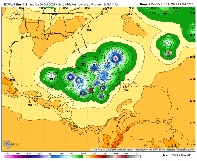
No sub-900 hPa ensemble members on the latest GDM-FNV run as far as I could tell (there have been one or two on many of the recent ones) but there are at least two that go below 910 & plenty more in the 920s and 930s. As one might expect, it's the member lows that track further west and slow or stall in the western Caribbean that tend to have the really low pressures, although there's a not-insignificant number that turn north sooner and still reach or approach MH intensity.
1 likes
Return to “Active Storms/Invests - Atlantic/EastPAC/CentralPAC/MED”
Who is online
Users browsing this forum: Majestic-12 [Bot] and 103 guests